Bridge Statistics for Saratoga Springs, New York (NY)
Condition, Traffic, Stress, Structural Evaluation, Project Costs
- National Bridge Inventory (NBI) Statistics
- 31Number of bridges
- 226ft / 69.4mTotal length
- $52,465,000Total costs
- 283,098Total average daily traffic
- 12,871Total average daily truck traffic
- National Bridge Inventory (NBI) Registered Bridges for Saratoga Springs
- No street view available for this location
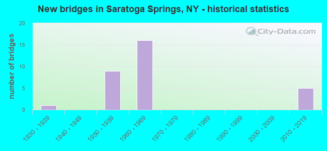
- New bridges - historical statistics
- 11930-1939
- 91950-1959
- 161960-1969
- 52010-2019
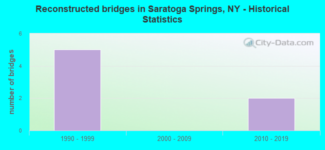
- Reconstructed bridges - Historical Statistics
- 51990-1999
- 02000-2009
- 22010-2019
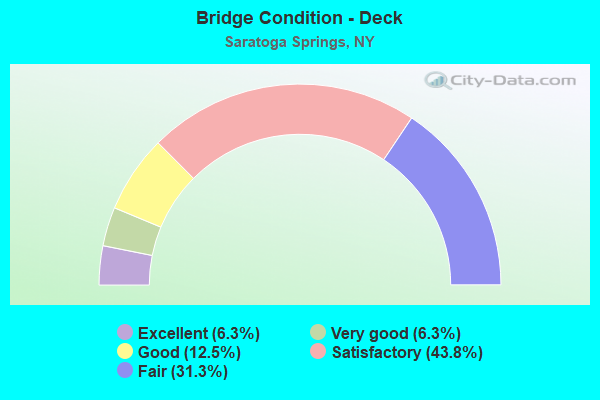
- Bridge Condition - Deck
- 6.3%Excellent
- 6.3%Very good
- 12.5%Good
- 43.8%Satisfactory
- 31.3%Fair
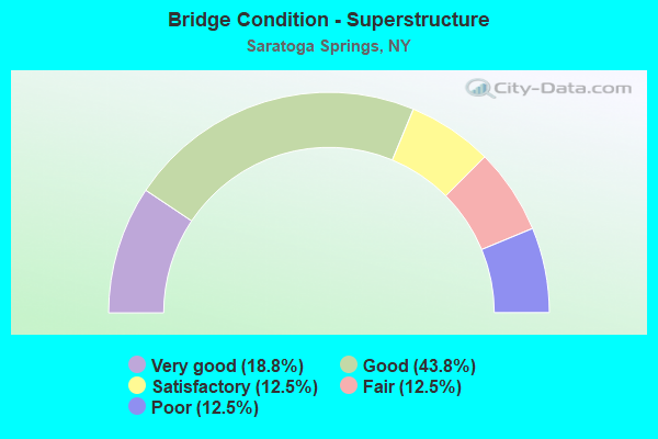
- Bridge Condition - Superstructure
- 18.8%Very good
- 43.8%Good
- 12.5%Satisfactory
- 12.5%Fair
- 12.5%Poor
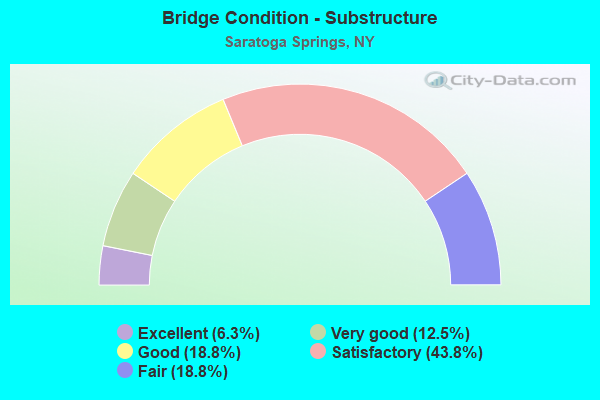
- Bridge Condition - Substructure
- 6.3%Excellent
- 12.5%Very good
- 18.8%Good
- 43.8%Satisfactory
- 18.8%Fair
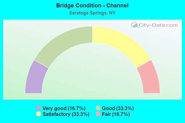
- Bridge Condition - Channel
- 16.7%Very good
- 33.3%Good
- 33.3%Satisfactory
- 16.7%Fair
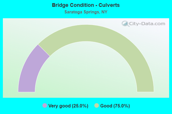
- Bridge Condition - Culverts
- 25.0%Very good
- 75.0%Good
Find on map >> Show street view
Structure Number: 100666, Location: 1.3 MI W JCT RTS 9 & 9N (Lat: 43.085542, Lng: -73.809964), Route carried "on" structure: State highway 9N, Year Built: 1959, Status: Open, Structure Length: 1.86m (6.10ft), Average Daily Traffic: 10,683 (year 2018), Truck Traffic: 5%, Average Future Daily Traffic: 12,977 (year 2040), Features Intersected: D&H RR (MP 37.27)
Minimum Vertical Clearance: 30+ m (98+ ft), Kilometerpoint: 2.060, Lanes on structure: 2, Base Highway Network: Yes, Owner: State Highway Agency, Approaching Roadway Width: 10.4m (34.1ft), Material/Design: Steel, Design/Construction: Stringer/Multi-beam, Number Of Spans In Main Unit: 1, Length of Maximum Span: 17.3m (56.8ft), Curb or Sidewalk Widths: Left: 1.2m (3.9ft), Right: 1.2m (3.9ft), Curb-To-Curb Width: 11.0m (36.1ft), Out-to-Out Width: 14.1m (46.3ft)
Condition: Deck: Satisfactory, Superstructure: Fair, Substructure: Satisfactory, Operating Rating: 66.4 metric tons, Method Used To Determine Operating Rating: Load and Resistance Factor Rating (LRFR) rating reported by rating factor(RF) method using HL-93 loadings, Inventory Rating: 51.2 metric tons, Method Used To Determine Inventory Rating: Load and Resistance Factor Rating (LRFR) rating reported by rating factor(RF) method using HL-93 loadings, Structural Evaluation: Somewhat better than minimum adequacy, Deck Geometry: Meets minimum limits, Underclear: Meets minimum limits, Approach Roadway Alignment: Equal to present desirable criteria, Length Of Structure Improvement: 1.85m (6.07ft), Designated Inspection Frequency: Every 24 months, Inspection Date: July 2020, Bridge Improvement Cost: $1,496,000, Roadway Improvement Cost: $876,000, Total Project Cost: $2,371,000 ( Estimate for 2021), Deck Structure Type: Concrete Cast-file-Place, Wearing Surface/Protective System: Wearing Surface: Bituminous
Find on map >> Show street view
Structure Number: 1007069, Location: JCT RTE 9P & I87 (Lat: 43.071325, Lng: -73.751167), Route carried "on" structure: State highway 9P, Year Built: 2012, Status: Open, Structure Length: 8.78m (28.81ft), Average Daily Traffic: 8,586 (year 2020), Truck Traffic: 9%, Average Future Daily Traffic: 10,430 (year 2040), Design Load: HL 93, Features Intersected: 87I 87I15091205 NB, RTE
Minimum Vertical Clearance: 30+ m (98+ ft), Kilometerpoint: 16.315, Lanes on structure: 4, Lanes under structure: 7, Base Highway Network: Yes, Owner: State Highway Agency, Approaching Roadway Width: 22.9m (75.1ft), Material/Design: Steel continuous, Design/Construction: Stringer/Multi-beam, Number Of Spans In Main Unit: 2, Length of Maximum Span: 43.0m (141.1ft), Curb-To-Curb Width: 22.8m (74.8ft), Out-to-Out Width: 24.0m (78.7ft)
Condition: Deck: Good, Superstructure: Very good, Substructure: Very good, Operating Rating: 68.4 metric tons, Method Used To Determine Operating Rating: Load and Resistance Factor Rating (LRFR) rating reported by rating factor(RF) method using HL-93 loadings, Inventory Rating: 52.5 metric tons, Method Used To Determine Inventory Rating: Load and Resistance Factor Rating (LRFR) rating reported by rating factor(RF) method using HL-93 loadings, Structural Evaluation: Equal to present desirable criteria, Deck Geometry: Superior to present desirable criteria, Underclear: High priority of corrective action, Approach Roadway Alignment: Equal to present desirable criteria, Length Of Structure Improvement: 8.77m (28.77ft), Designated Inspection Frequency: Every 24 months, Inspection Date: May 2020, Bridge Improvement Cost: $5,142,000, Roadway Improvement Cost: $3,011,000, Total Project Cost: $8,153,000 ( Estimate for 2021), Deck Structure Type: Concrete Cast-file-Place, Wearing Surface/Protective System: Wearing Surface: Integral Concrete, Deck Protection: Epoxy Coated Reinforcing
Find on map >> Show street view
Structure Number: 102064, Location: 2.2 MI W JCT RTS 9 & 29 (Lat: 43.077153, Lng: -73.826531), Route carried "on" structure: State highway 29, Year Built: 1957, Status: Open, Structure Length: 0.73m (2.40ft), Average Daily Traffic: 7,186 (year 2017), Truck Traffic: 6%, Average Future Daily Traffic: 7,219 (year 2040), Features Intersected: SLADE CREEK
Minimum Vertical Clearance: 30+ m (98+ ft), Kilometerpoint: 25.004, Lanes on structure: 2, Base Highway Network: Yes, Owner: State Highway Agency, Approaching Roadway Width: 9.1m (29.9ft), Skew: 3 degrees, Material/Design: Steel, Design/Construction: Culvert, Number Of Spans In Main Unit: 1, Length of Maximum Span: 7.0m (23.0ft)
Condition: Channel: Satisfactory, Culverts: Good, Operating Rating: 77.6 metric tons, Method Used To Determine Operating Rating: Field evaluation and documented engineering judgment, Inventory Rating: 32.7 metric tons, Method Used To Determine Inventory Rating: Field evaluation and documented engineering judgment, Structural Evaluation: Better than present minimum criteria, Waterway Adequacy: Superior to present desirable criteria, Approach Roadway Alignment: Equal to present desirable criteria, Length Of Structure Improvement: 0.73m (2.40ft), Designated Inspection Frequency: Every 24 months, Inspection Date: September 2020, Bridge Improvement Cost: $163,000, Roadway Improvement Cost: $96,000, Total Project Cost: $259,000 ( Estimate for 2021)
Find on map >> Show street view
Structure Number: 102065, Location: 1.4 MI W JCT US 9 & SH 29 (Lat: 43.078772, Lng: -73.811144), Route carried "on" structure: State highway 29, Year Built: 1959, Status: Open, Structure Length: 1.89m (6.20ft), Average Daily Traffic: 7,186 (year 2017), Truck Traffic: 6%, Average Future Daily Traffic: 7,219 (year 2040), Design Load: HS 20, Features Intersected: DELAWARE & HUDSON
Minimum Vertical Clearance: 30+ m (98+ ft), Kilometerpoint: 26.259, Lanes on structure: 2, Base Highway Network: Yes, Owner: State Highway Agency, Approaching Roadway Width: 11.0m (36.1ft), Skew: 1 degrees, Material/Design: Steel, Design/Construction: Stringer/Multi-beam, Number Of Spans In Main Unit: 1, Length of Maximum Span: 17.6m (57.7ft), Curb-To-Curb Width: 11.0m (36.1ft), Out-to-Out Width: 14.2m (46.6ft)
Condition: Deck: Fair, Superstructure: Good, Substructure: Fair, Operating Rating: 73.5 metric tons, Method Used To Determine Operating Rating: Load Factor (LF), Inventory Rating: 43.5 metric tons, Method Used To Determine Inventory Rating: Load Factor (LF), Structural Evaluation: Somewhat better than minimum adequacy, Deck Geometry: Meets minimum limits, Underclear: Meets minimum limits, Approach Roadway Alignment: Equal to present desirable criteria, Length Of Structure Improvement: 1.88m (6.17ft), Designated Inspection Frequency: Every 24 months, Inspection Date: September 2021, Bridge Improvement Cost: $4,192,000, Roadway Improvement Cost: $2,455,000, Total Project Cost: $6,647,000 ( Estimate for 2021), Deck Structure Type: Concrete Cast-file-Place, Wearing Surface/Protective System: Wearing Surface: Bituminous
Find on map >> Show street view
Structure Number: 1020661, Location: IN SARATOGA SPRINGS (Lat: 43.084339, Lng: -73.748914), Route carried "on" structure: Interstate 87, Year Built: 1962, Status: Open, Structure Length: 3.44m (11.29ft), Average Daily Traffic: 23,781 (year 2006), Truck Traffic: 9%, Average Future Daily Traffic: 33,293 (year 2026), Design Load: H 20, Features Intersected: RTE 29
Minimum Vertical Clearance: 30+ m (98+ ft), Kilometerpoint: 34.368, Lanes on structure: 3, Lanes under structure: 2, Base Highway Network: Yes, Owner: State Highway Agency, Approaching Roadway Width: 12.8m (42.0ft), Material/Design: Steel, Design/Construction: Stringer/Multi-beam, Number Of Spans In Main Unit: 1, Length of Maximum Span: 32.9m (107.9ft), Curb or Sidewalk Widths: Left: 0.5m (1.6ft), Right: 0.5m (1.6ft), Curb-To-Curb Width: 12.3m (40.4ft), Out-to-Out Width: 14.0m (45.9ft)
Condition: Deck: Satisfactory, Superstructure: Good, Substructure: Satisfactory, Operating Rating: 80.7 metric tons, Method Used To Determine Operating Rating: Load Factor (LF), Inventory Rating: 48.1 metric tons, Method Used To Determine Inventory Rating: Load Factor (LF), Structural Evaluation: Equal to present minimum criteria, Deck Geometry: High priority of replacement, Underclear: Somewhat better than minimum adequacy, Approach Roadway Alignment: Equal to present desirable criteria, Length Of Structure Improvement: 3.44m (11.29ft), Designated Inspection Frequency: Every 24 months, Inspection Date: May 2020, Bridge Improvement Cost: $1,145,000, Roadway Improvement Cost: $671,000, Total Project Cost: $1,816,000 ( Estimate for 2021), Deck Structure Type: Concrete Cast-file-Place, Wearing Surface/Protective System: Wearing Surface: Bituminous
Find on map >> Show street view
Structure Number: 1020662, Location: IN SARATOGA SPRINGS (Lat: 43.084378, Lng: -73.748344), Route carried "on" structure: Interstate 87, Year Built: 1962, Status: Open, Structure Length: 3.44m (11.29ft), Average Daily Traffic: 19,311 (year 2016), Truck Traffic: 18%, Average Future Daily Traffic: 30,601 (year 2040), Design Load: H 20, Features Intersected: RTE 29
Minimum Vertical Clearance: 30+ m (98+ ft), Kilometerpoint: 34.352, Lanes on structure: 3, Lanes under structure: 2, Base Highway Network: Yes, Owner: State Highway Agency, Approaching Roadway Width: 13.2m (43.3ft), Material/Design: Steel, Design/Construction: Stringer/Multi-beam, Number Of Spans In Main Unit: 1, Length of Maximum Span: 32.9m (107.9ft), Curb or Sidewalk Widths: Left: 0.5m (1.6ft), Right: 0.5m (1.6ft), Curb-To-Curb Width: 12.3m (40.4ft), Out-to-Out Width: 14.0m (45.9ft)
Condition: Deck: Fair, Superstructure: Satisfactory, Substructure: Satisfactory, Operating Rating: 80.7 metric tons, Method Used To Determine Operating Rating: Load Factor (LF), Inventory Rating: 48.1 metric tons, Method Used To Determine Inventory Rating: Load Factor (LF), Structural Evaluation: Equal to present minimum criteria, Deck Geometry: High priority of replacement, Underclear: Meets minimum limits, Approach Roadway Alignment: Equal to present desirable criteria, Length Of Structure Improvement: 3.44m (11.29ft), Designated Inspection Frequency: Every 24 months, Inspection Date: June 2021, Bridge Improvement Cost: $1,145,000, Roadway Improvement Cost: $671,000, Total Project Cost: $1,816,000 ( Estimate for 2021), Deck Structure Type: Concrete Cast-file-Place, Wearing Surface/Protective System: Wearing Surface: Bituminous
Find on map >> Show street view
Structure Number: 102636, Location: JCT SH 50 & D&H RAILWAY (Lat: 43.042775, Lng: -73.818392), Route carried "on" structure: State highway 50, Year Built: 1959, Year Reconstructed: 1995, Status: Open, Structure Length: 6.83m (22.41ft), Average Daily Traffic: 8,738 (year 2017), Truck Traffic: 7%, Average Future Daily Traffic: 8,779 (year 2040), Design Load: HS 20, Features Intersected: DELAWARE & HUDSON
Minimum Vertical Clearance: 30+ m (98+ ft), Kilometerpoint: 17.409, Lanes on structure: 4, Base Highway Network: Yes, Owner: State Highway Agency, Approaching Roadway Width: 17.1m (56.1ft), Material/Design: Steel, Design/Construction: Girder and Floorbeam System, Number Of Spans In Main Unit: 2, Length of Maximum Span: 33.2m (108.9ft), Curb-To-Curb Width: 16.7m (54.8ft), Out-to-Out Width: 18.9m (62.0ft)
Condition: Deck: Satisfactory, Superstructure: Fair, Substructure: Satisfactory, Operating Rating: 61.7 metric tons, Method Used To Determine Operating Rating: Load Factor (LF), Inventory Rating: 37.2 metric tons, Method Used To Determine Inventory Rating: Load Factor (LF), Structural Evaluation: Somewhat better than minimum adequacy, Deck Geometry: Somewhat better than minimum adequacy, Underclear: Meets minimum limits, Approach Roadway Alignment: Equal to present desirable criteria, Length Of Structure Improvement: 6.82m (22.38ft), Designated Inspection Frequency: Every 24 months, Critical Feature Inspection Frequency: Every 24 months, Inspection Date: September 2020, Critical Feature Inspection Date: September 2020, Bridge Improvement Cost: $4,200,000, Roadway Improvement Cost: $2,459,000, Total Project Cost: $6,659,000 ( Estimate for 2021), Deck Structure Type: Concrete Cast-file-Place, Wearing Surface/Protective System: Wearing Surface: Integral Concrete
Find on map >> Show street view
Structure Number: 102638, Location: JCT RTE 50 & I87 (Lat: 43.096394, Lng: -73.752739), Route carried "on" structure: State highway 50, Year Built: 1962, Year Reconstructed: 1990, Status: Open, Structure Length: 4.69m (15.39ft), Average Daily Traffic: 24,772 (year 2020), Truck Traffic: 5%, Average Future Daily Traffic: 28,705 (year 2040), Design Load: HS 20, Features Intersected: RTE I87
Minimum Vertical Clearance: 30+ m (98+ ft), Kilometerpoint: 26.018, Lanes on structure: 6, Lanes under structure: 3, Base Highway Network: Yes, Owner: State Highway Agency, Approaching Roadway Width: 21.3m (69.9ft), Skew: 1 degrees, Material/Design: Steel, Design/Construction: Stringer/Multi-beam, Number Of Spans In Main Unit: 3, Length of Maximum Span: 17.3m (56.8ft), Curb or Sidewalk Widths: Left: 0.0m, Right: 3.0m (9.8ft), Curb-To-Curb Width: 21.3m (69.9ft), Out-to-Out Width: 25.3m (83.0ft)
Condition: Deck: Satisfactory, Superstructure: Good, Substructure: Good, Operating Rating: 58.1 metric tons, Method Used To Determine Operating Rating: Load Factor (LF), Inventory Rating: 34.5 metric tons, Method Used To Determine Inventory Rating: Load Factor (LF), Structural Evaluation: Better than present minimum criteria, Deck Geometry: High priority of replacement, Underclear: Meets minimum limits, Approach Roadway Alignment: Equal to present desirable criteria, Length Of Structure Improvement: 4.69m (15.39ft), Designated Inspection Frequency: Every 24 months, Inspection Date: September 2021, Bridge Improvement Cost: $2,671,000, Roadway Improvement Cost: $1,564,000, Total Project Cost: $4,235,000 ( Estimate for 2021), Deck Structure Type: Concrete Cast-file-Place, Wearing Surface/Protective System: Wearing Surface: Integral Concrete
Find on map >> Show street view
Structure Number: 103333, Location: 2.0 MI N JCT RT 9 & I87RT (Lat: 43.045653, Lng: -73.773575), Route carried "on" structure: County highway , Year Built: 1962, Year Reconstructed: 1996, Status: Open, Structure Length: 4.24m (13.91ft), Average Daily Traffic: 459 (year 2020), Truck Traffic: 7%, Average Future Daily Traffic: 567 (year 2040), Design Load: H 20, Features Intersected: RTE I87, Facility Carried by Structure: NELSON AVE EXT
Minimum Vertical Clearance: 30+ m (98+ ft), Kilometerpoint: 4.023, Lanes on structure: 2, Lanes under structure: 3, Owner: State Highway Agency, Approaching Roadway Width: 10.1m (33.1ft), Material/Design: Prestressed concrete, Design/Construction: Box Beam or Girders - Multiple, Number Of Spans In Main Unit: 3, Length of Maximum Span: 16.7m (54.8ft), Curb or Sidewalk Widths: Left: 0.5m (1.6ft), Right: 0.5m (1.6ft), Curb-To-Curb Width: 9.1m (29.9ft), Out-to-Out Width: 10.8m (35.4ft)
Condition: Deck: Fair, Superstructure: Poor, Substructure: Fair, Operating Rating: 46.3 metric tons, Method Used To Determine Operating Rating: Load Factor (LF), Inventory Rating: 27.2 metric tons, Method Used To Determine Inventory Rating: Load Factor (LF), Structural Evaluation: Meets minimum limits, Deck Geometry: Equal to present minimum criteria, Underclear: High priority of corrective action, Approach Roadway Alignment: Equal to present desirable criteria, Length Of Structure Improvement: 4.23m (13.88ft), Designated Inspection Frequency: Every 24 months, Inspection Date: July 2021, Bridge Improvement Cost: $1,279,000, Roadway Improvement Cost: $749,000, Total Project Cost: $2,028,000 ( Estimate for 2021), Wearing Surface/Protective System: Wearing Surface: Bituminous, Membrane: Other
Find on map >> Show street view
Structure Number: 103334, Location: 2.75 MI N JCT US 9 & I87 (Lat: 43.055528, Lng: -73.765625), Route carried "on" structure: County highway , Year Built: 2018, Status: Open, Structure Length: 11.00m (36.09ft), Average Daily Traffic: 2,616 (year 2019), Truck Traffic: 4%, Average Future Daily Traffic: 3,236 (year 2040), Design Load: HL 93, Features Intersected: 87I 87I15091191, RTE I87, Facility Carried by Structure: CRESCENT AVENUE
Minimum Vertical Clearance: 30+ m (98+ ft), Kilometerpoint: 1.883, Lanes on structure: 2, Lanes under structure: 6, Owner: State Highway Agency, Approaching Roadway Width: 9.8m (32.2ft), Material/Design: Steel continuous, Design/Construction: Stringer/Multi-beam, Number Of Spans In Main Unit: 3, Length of Maximum Span: 40.5m (132.9ft), Curb-To-Curb Width: 9.8m (32.2ft), Out-to-Out Width: 11.0m (36.1ft)
Condition: Deck: Excellent, Superstructure: Very good, Substructure: Excellent, Operating Rating: 53.5 metric tons, Method Used To Determine Operating Rating: Load Factor (LF), Inventory Rating: 31.8 metric tons, Method Used To Determine Inventory Rating: Load Factor (LF), Structural Evaluation: Better than present minimum criteria, Deck Geometry: Meets minimum limits, Underclear: High priority of corrective action, Approach Roadway Alignment: Equal to present desirable criteria, Length Of Structure Improvement: 11.00m (36.09ft), Designated Inspection Frequency: Every 24 months, Inspection Date: September 2020, Bridge Improvement Cost: $2,728,000, Roadway Improvement Cost: $1,598,000, Total Project Cost: $4,326,000 ( Estimate for 2021), Deck Structure Type: Concrete Cast-file-Place, Wearing Surface/Protective System: Wearing Surface: Integral Concrete, Deck Protection: Epoxy Coated Reinforcing
Find on map >> Show street view
Structure Number: 109593, Location: 1.1 MI NE JCT RTS 9 & 50 (Lat: 43.096719, Lng: -73.752047), Route carried "on" structure: State highway 50, Year Built: 1962, Year Reconstructed: 1990, Status: Open, Structure Length: 4.72m (15.49ft), Average Daily Traffic: 25,200 (year 2020), Truck Traffic: 5%, Average Future Daily Traffic: 30,612 (year 2040), Design Load: HS 20, Features Intersected: RTE I87
Minimum Vertical Clearance: 30+ m (98+ ft), Kilometerpoint: 26.098, Lanes on structure: 6, Lanes under structure: 3, Base Highway Network: Yes, Owner: State Highway Agency, Approaching Roadway Width: 21.3m (69.9ft), Skew: 1 degrees, Material/Design: Steel, Design/Construction: Stringer/Multi-beam, Number Of Spans In Main Unit: 3, Length of Maximum Span: 17.3m (56.8ft), Curb or Sidewalk Widths: Left: 0.0m, Right: 3.0m (9.8ft), Curb-To-Curb Width: 21.3m (69.9ft), Out-to-Out Width: 25.3m (83.0ft)
Condition: Deck: Satisfactory, Superstructure: Good, Substructure: Good, Operating Rating: 58.1 metric tons, Method Used To Determine Operating Rating: Load Factor (LF), Inventory Rating: 34.5 metric tons, Method Used To Determine Inventory Rating: Load Factor (LF), Structural Evaluation: Better than present minimum criteria, Deck Geometry: High priority of replacement, Underclear: Meets minimum limits, Approach Roadway Alignment: Equal to present desirable criteria, Length Of Structure Improvement: 4.72m (15.49ft), Designated Inspection Frequency: Every 24 months, Inspection Date: September 2021, Bridge Improvement Cost: $2,686,000, Roadway Improvement Cost: $1,573,000, Total Project Cost: $4,259,000 ( Estimate for 2021), Deck Structure Type: Concrete Cast-file-Place, Wearing Surface/Protective System: Wearing Surface: Integral Concrete
Find on map >> Show street view
Structure Number: 109594, Location: 2.0 MI N RT 9 & I87 LT (Lat: 43.045342, Lng: -73.772728), Route carried "on" structure: County highway , Year Built: 1962, Year Reconstructed: 1996, Status: Open, Structure Length: 4.33m (14.21ft), Average Daily Traffic: 459 (year 2020), Truck Traffic: 7%, Average Future Daily Traffic: 567 (year 2040), Design Load: H 20, Features Intersected: RTE I87, Facility Carried by Structure: NELSON AVE EXT
Minimum Vertical Clearance: 30+ m (98+ ft), Kilometerpoint: 3.958, Lanes on structure: 2, Lanes under structure: 3, Owner: State Highway Agency, Approaching Roadway Width: 10.4m (34.1ft), Material/Design: Prestressed concrete, Design/Construction: Box Beam or Girders - Multiple, Number Of Spans In Main Unit: 3, Length of Maximum Span: 16.7m (54.8ft), Curb or Sidewalk Widths: Left: 0.5m (1.6ft), Right: 0.5m (1.6ft), Curb-To-Curb Width: 9.1m (29.9ft), Out-to-Out Width: 10.8m (35.4ft)
Condition: Deck: Fair, Superstructure: Poor, Substructure: Fair, Operating Rating: 43.5 metric tons, Method Used To Determine Operating Rating: Load Factor (LF), Inventory Rating: 25.4 metric tons, Method Used To Determine Inventory Rating: Load Factor (LF), Structural Evaluation: Meets minimum limits, Deck Geometry: Equal to present minimum criteria, Underclear: High priority of corrective action, Approach Roadway Alignment: Equal to present desirable criteria, Length Of Structure Improvement: 4.32m (14.17ft), Designated Inspection Frequency: Every 24 months, Inspection Date: July 2021, Bridge Improvement Cost: $1,296,000, Roadway Improvement Cost: $759,000, Total Project Cost: $2,055,000 ( Estimate for 2021), Wearing Surface/Protective System: Wearing Surface: Bituminous, Membrane: Other
Find on map >> Show street view
Structure Number: 226003, Location: 1 MI SOUTH JCT I87&NY9P (Lat: 43.053525, Lng: -73.752978), Route carried "on" structure: Other road , Year Built: 1950, Status: Open, Structure Length: 0.88m (2.89ft), Average Daily Traffic: 2,616 (year 2019), Truck Traffic: 4%, Average Future Daily Traffic: 3,236 (year 2040), Design Load: H 20, Features Intersected: LAKE LONELY OUTLT, Facility Carried by Structure: CRESCENT AVE CR22
Minimum Vertical Clearance: 30+ m (98+ ft), Kilometerpoint: 3.025, Lanes on structure: 2, Owner: County Highway Agency, Approaching Roadway Width: 6.1m (20.0ft), Material/Design: Steel, Design/Construction: Stringer/Multi-beam, Number Of Spans In Main Unit: 1, Length of Maximum Span: 8.2m (26.9ft), Curb-To-Curb Width: 7.1m (23.3ft), Out-to-Out Width: 7.7m (25.3ft)
Condition: Deck: Good, Superstructure: Good, Substructure: Satisfactory, Channel: Good, Operating Rating: 53.1 metric tons, Method Used To Determine Operating Rating: Load and Resistance Factor Rating (LRFR) rating reported by rating factor(RF) method using HL-93 loadings, Inventory Rating: 40.8 metric tons, Method Used To Determine Inventory Rating: Load and Resistance Factor Rating (LRFR) rating reported by rating factor(RF) method using HL-93 loadings, Structural Evaluation: Equal to present minimum criteria, Deck Geometry: High priority of replacement, Waterway Adequacy: Somewhat better than minimum adequacy, Approach Roadway Alignment: Somewhat better than minimum adequacy, Length Of Structure Improvement: 0.88m (2.89ft), Designated Inspection Frequency: Every 24 months, Inspection Date: May 2020, Bridge Improvement Cost: $274,000, Roadway Improvement Cost: $160,000, Total Project Cost: $434,000 ( Estimate for 2021), Deck Structure Type: Concrete Cast-file-Place, Wearing Surface/Protective System: Wearing Surface: Bituminous
Find on map >> Show street view
Structure Number: 226005, Location: .25 MI WEST OF SARATOGA (Lat: 43.074467, Lng: -73.812533), Route carried "on" structure: Other road , Year Built: 1956, Status: Open, Structure Length: 2.19m (7.19ft), Average Daily Traffic: 3,389 (year 2020), Truck Traffic: 3%, Average Future Daily Traffic: 4,193 (year 2040), Features Intersected: DELAWARE & HUDSON, Facility Carried by Structure: GRAND AVENUE
Minimum Vertical Clearance: 30+ m (98+ ft), Kilometerpoint: 2.767, Lanes on structure: 2, Owner: City or Municipal Highway Agency, Approaching Roadway Width: 7.9m (25.9ft), Skew: 3 degrees, Material/Design: Steel, Design/Construction: Stringer/Multi-beam, Number Of Spans In Main Unit: 1, Length of Maximum Span: 20.4m (66.9ft), Curb-To-Curb Width: 7.9m (25.9ft), Out-to-Out Width: 10.1m (33.1ft)
Condition: Deck: Fair, Superstructure: Good, Substructure: Satisfactory, Operating Rating: 79.7 metric tons, Method Used To Determine Operating Rating: Load and Resistance Factor Rating (LRFR) rating reported by rating factor(RF) method using HL-93 loadings, Inventory Rating: 61.6 metric tons, Method Used To Determine Inventory Rating: Load and Resistance Factor Rating (LRFR) rating reported by rating factor(RF) method using HL-93 loadings, Structural Evaluation: Equal to present minimum criteria, Deck Geometry: High priority of corrective action, Underclear: Meets minimum limits, Approach Roadway Alignment: Better than present minimum criteria, Length Of Structure Improvement: 2.19m (7.19ft), Designated Inspection Frequency: Every 24 months, Inspection Date: August 2020, Bridge Improvement Cost: $1,233,000, Roadway Improvement Cost: $722,000, Total Project Cost: $1,954,000 ( Estimate for 2021), Deck Structure Type: Concrete Cast-file-Place, Wearing Surface/Protective System: Wearing Surface: Integral Concrete
Find on map >> Show street view
Structure Number: 227061, Location: 1 MILE SW I-87 EXIT 15 (Lat: 43.089400, Lng: -73.763344), Route carried "on" structure: Alternate City street , Year Built: 2010, Status: Open, Structure Length: 1.37m (4.49ft), Average Daily Traffic: 1,437 (year 2019), Truck Traffic: 3%, Average Future Daily Traffic: 2,012 (year 2039), Features Intersected: SPRING RUN TRAIL, Facility Carried by Structure: EXCELSIOR SPRINGS
Minimum Vertical Clearance: 30+ m (98+ ft), Kilometerpoint: 0.579, Lanes on structure: 2, Owner: City or Municipal Highway Agency, Approaching Roadway Width: 9.8m (32.2ft), Skew: 1 degrees, Material/Design: Concrete, Design/Construction: Culvert, Number Of Spans In Main Unit: 1, Length of Maximum Span: 13.1m (43.0ft), Curb or Sidewalk Widths: Left: 0.0m, Right: 1.5m (4.9ft)
Condition: Culverts: Good, Operating Rating: 81.9 metric tons, Method Used To Determine Operating Rating: Field evaluation and documented engineering judgment, Inventory Rating: 40.8 metric tons, Method Used To Determine Inventory Rating: Field evaluation and documented engineering judgment, Structural Evaluation: Better than present minimum criteria, Approach Roadway Alignment: Somewhat better than minimum adequacy, Length Of Structure Improvement: 1.37m (4.49ft), Designated Inspection Frequency: Every 24 months, Inspection Date: June 2021, Bridge Improvement Cost: $446,000, Roadway Improvement Cost: $261,000, Total Project Cost: $707,000 ( Estimate for 2021)
Find on map >> Show street view
Structure Number: 330446, Location: 1.3 MI NW OF BALLSTON SPA (Lat: 43.019036, Lng: -73.825675), Route carried "on" structure: County highway , Year Built: 1966, Year Reconstructed: 2015, Status: Open, Structure Length: 3.38m (11.09ft), Average Daily Traffic: 10,136 (year 2018), Truck Traffic: 5%, Average Future Daily Traffic: 12,313 (year 2040), Design Load: HS 20, Features Intersected: KAYADEROSSERAS CREEK, Facility Carried by Structure: CR 45, NORTH LINE
Minimum Vertical Clearance: 30+ m (98+ ft), Kilometerpoint: 24.215, Lanes on structure: 2, Owner: County Highway Agency, Approaching Roadway Width: 7.3m (24.0ft), Skew: 1 degrees, Material/Design: Steel, Design/Construction: Stringer/Multi-beam, Number Of Spans In Main Unit: 1, Length of Maximum Span: 32.6m (107.0ft), Curb-To-Curb Width: 7.3m (24.0ft), Out-to-Out Width: 8.7m (28.5ft)
Condition: Deck: Satisfactory, Superstructure: Good, Substructure: Good, Channel: Good, Operating Rating: 54.4 metric tons, Method Used To Determine Operating Rating: Load Factor (LF), Inventory Rating: 32.7 metric tons, Method Used To Determine Inventory Rating: Load Factor (LF), Structural Evaluation: Better than present minimum criteria, Deck Geometry: High priority of replacement, Waterway Adequacy: Superior to present desirable criteria, Approach Roadway Alignment: Equal to present desirable criteria, Length Of Structure Improvement: 3.38m (11.09ft), Designated Inspection Frequency: Every 24 months, Inspection Date: April 2020, Bridge Improvement Cost: $705,000, Roadway Improvement Cost: $413,000, Total Project Cost: $1,118,000 ( Estimate for 2021), Deck Structure Type: Concrete Cast-file-Place, Wearing Surface/Protective System: Wearing Surface: Bituminous
Find on map >> Show street view
Structure Number: 33642, Location: CITY OF SARATOGA SPRINGS (Lat: 43.059744, Lng: -73.818094), Route carried "on" structure: County highway , Year Built: 1956, Year Reconstructed: 2010, Status: Open, Structure Length: 2.80m (9.19ft), Average Daily Traffic: 8,941 (year 2017), Truck Traffic: 6%, Average Future Daily Traffic: 10,861 (year 2040), Design Load: HS 25 or greater, Features Intersected: D&H RR (MP35.43), Facility Carried by Structure: CR43, GEYSER RD.
Minimum Vertical Clearance: 30+ m (98+ ft), Kilometerpoint: 2.349, Lanes on structure: 2, Owner: Railroad, Approaching Roadway Width: 9.4m (30.8ft), Material/Design: Steel, Design/Construction: Stringer/Multi-beam, Number Of Spans In Main Unit: 1, Length of Maximum Span: 26.8m (87.9ft), Curb or Sidewalk Widths: Left: 1.5m (4.9ft), Right: 0.0m, Curb-To-Curb Width: 9.4m (30.8ft), Out-to-Out Width: 12.2m (40.0ft)
Condition: Deck: Very good, Superstructure: Very good, Substructure: Very good, Operating Rating: 81.6 metric tons, Method Used To Determine Operating Rating: Load Factor (LF), Inventory Rating: 47.2 metric tons, Method Used To Determine Inventory Rating: Load Factor (LF), Structural Evaluation: Equal to present desirable criteria, Deck Geometry: High priority of corrective action, Underclear: Meets minimum limits, Approach Roadway Alignment: Somewhat better than minimum adequacy, Length Of Structure Improvement: 2.80m (9.19ft), Designated Inspection Frequency: Every 24 months, Inspection Date: July 2020, Bridge Improvement Cost: $1,489,000, Roadway Improvement Cost: $872,000, Total Project Cost: $2,362,000 ( Estimate for 2021), Deck Structure Type: Other, Wearing Surface/Protective System: Wearing Surface: Bituminous
Find on map >> Show street view
Structure Number: 55242, Location: SARATOGA SPA STATE PARK (Lat: 43.044706, Lng: -73.801725), Route carried "on" structure: ServiceOther road , Year Built: 1961, Status: Open, Structure Length: 1.01m (3.31ft), Average Daily Traffic: 300 (year 2009), Average Future Daily Traffic: 420 (year 2029), Features Intersected: GEYSER BROOK, Facility Carried by Structure: EAST WEST ROAD
Minimum Vertical Clearance: 30+ m (98+ ft), Kilometerpoint: 0.000, Lanes on structure: 2, Owner: State Agenciy, Approaching Roadway Width: 6.8m (22.3ft), Material/Design: Concrete continuous, Design/Construction: Culvert, Number Of Spans In Main Unit: 2, Length of Maximum Span: 4.5m (14.8ft), Curb or Sidewalk Widths: Left: 0.7m (2.3ft), Right: 0.7m (2.3ft), Curb-To-Curb Width: 6.8m (22.3ft), Out-to-Out Width: 8.9m (29.2ft)
Condition: Channel: Fair, Culverts: Good, Operating Rating: 71.7 metric tons, Method Used To Determine Operating Rating: Load Factor (LF), Inventory Rating: 42.6 metric tons, Method Used To Determine Inventory Rating: Load Factor (LF), Structural Evaluation: Better than present minimum criteria, Deck Geometry: Meets minimum limits, Waterway Adequacy: Superior to present desirable criteria, Approach Roadway Alignment: Equal to present desirable criteria, Length Of Structure Improvement: 1.00m (3.28ft), Designated Inspection Frequency: Every 24 months, Inspection Date: August 2020, Bridge Improvement Cost: $273,000, Roadway Improvement Cost: $160,000, Total Project Cost: $433,000 ( Estimate for 2021), Wearing Surface/Protective System: Wearing Surface: Bituminous
Find on map >> Show street view
Structure Number: 552445, Location: SARATOGA SPA STATE PARK (Lat: 43.047389, Lng: -73.802942), Route carried "on" structure: ServiceOther road , Year Built: 1961, Status: Open, Structure Length: 1.01m (3.31ft), Average Daily Traffic: 300 (year 2009), Average Future Daily Traffic: 420 (year 2029), Features Intersected: GEYSER BROOK, Facility Carried by Structure: PICNIC LOOP ROAD
Minimum Vertical Clearance: 30+ m (98+ ft), Kilometerpoint: 0.000, Lanes on structure: 2, Owner: State Agenciy, Approaching Roadway Width: 6.1m (20.0ft), Skew: 1 degrees, Material/Design: Concrete continuous, Design/Construction: Culvert, Number Of Spans In Main Unit: 2, Length of Maximum Span: 4.5m (14.8ft), Curb or Sidewalk Widths: Left: 0.7m (2.3ft), Right: 0.7m (2.3ft), Curb-To-Curb Width: 6.1m (20.0ft), Out-to-Out Width: 8.2m (26.9ft)
Condition: Channel: Satisfactory, Culverts: Very good, Operating Rating: 71.7 metric tons, Method Used To Determine Operating Rating: Load Factor (LF), Inventory Rating: 42.6 metric tons, Method Used To Determine Inventory Rating: Load Factor (LF), Structural Evaluation: Equal to present desirable criteria, Deck Geometry: Meets minimum limits, Waterway Adequacy: Superior to present desirable criteria, Approach Roadway Alignment: Equal to present desirable criteria, Length Of Structure Improvement: 1.00m (3.28ft), Designated Inspection Frequency: Every 24 months, Inspection Date: August 2020, Bridge Improvement Cost: $255,000, Roadway Improvement Cost: $150,000, Total Project Cost: $405,000 ( Estimate for 2021), Wearing Surface/Protective System: Wearing Surface: Bituminous
Find on map >> Show street view
Structure Number: 552446, Location: SARATOGA SPA STATE PARK (Lat: 43.051069, Lng: -73.805239), Route carried "on" structure: ServiceOther road , Year Built: 1930, Status: Open, Structure Length: 0.85m (2.79ft), Average Daily Traffic: 300 (year 2009), Truck Traffic: 5%, Average Future Daily Traffic: 420 (year 2029), Features Intersected: GEYSER BROOK, Facility Carried by Structure: PICNIC LOOP ROAD
Minimum Vertical Clearance: 30+ m (98+ ft), Kilometerpoint: 0.000, Lanes on structure: 2, Owner: State Agenciy, Approaching Roadway Width: 6.7m (22.0ft), Skew: 1 degrees, Material/Design: Concrete, Number Of Spans In Main Unit: 1, Length of Maximum Span: 7.9m (25.9ft), Curb or Sidewalk Widths: Left: 0.8m (2.6ft), Right: 0.8m (2.6ft), Curb-To-Curb Width: 6.7m (22.0ft), Out-to-Out Width: 8.9m (29.2ft)
Condition: Deck: Satisfactory, Superstructure: Satisfactory, Substructure: Satisfactory, Channel: Very good, Operating Rating: 70.5 metric tons, Method Used To Determine Operating Rating: Field evaluation and documented engineering judgment, Inventory Rating: 30.6 metric tons, Method Used To Determine Inventory Rating: Field evaluation and documented engineering judgment, Structural Evaluation: Equal to present minimum criteria, Deck Geometry: Meets minimum limits, Waterway Adequacy: Superior to present desirable criteria, Approach Roadway Alignment: Equal to present desirable criteria, Length Of Structure Improvement: 0.85m (2.79ft), Designated Inspection Frequency: Every 24 months, Inspection Date: August 2020, Bridge Improvement Cost: $270,000, Roadway Improvement Cost: $158,000, Total Project Cost: $428,000 ( Estimate for 2021), Wearing Surface/Protective System: Wearing Surface: Bituminous
Find on map >> Show street view
Structure Number: 1007069, Location: JCT RTE 9P & I87 (Lat: 43.071325, Lng: -73.751167), Route carried "under" structure: Interstate 87, Year Built: 2012, Structure Length: 0. m, Average Daily Traffic: 24,400 (year 1979), Features Intersected: 87I 87I15091205 NB, RTE, Facility Carried by Structure: RTE 9P
Minimum Vertical Clearance: 5.69m (18.67ft), Kilometerpoint: 33.033, Lanes on structure: 4, Lanes under structure: 3, Material/Design: Steel continuous, Design/Construction: Stringer/Multi-beam, Length of Maximum Span: 43.0m (141.1ft)
Find on map >> Show street view
Structure Number: 1020661, Location: IN SARATOGA SPRINGS (Lat: 43.084339, Lng: -73.748914), Route carried "under" structure: State highway 29, Year Built: 1962, Structure Length: 0. m, Average Daily Traffic: 6,888 (year 1998), Features Intersected: RTE 29, Facility Carried by Structure: RTE I87
Minimum Vertical Clearance: 4.39m (14.40ft), Kilometerpoint: 1.786, Lanes on structure: 3, Lanes under structure: 2, Material/Design: Steel, Design/Construction: Stringer/Multi-beam, Length of Maximum Span: 32.9m (107.9ft)
Find on map >> Show street view
Structure Number: 1020662, Location: IN SARATOGA SPRINGS (Lat: 43.084378, Lng: -73.748344), Route carried "under" structure: State highway 29, Year Built: 1962, Structure Length: 0. m, Average Daily Traffic: 6,888 (year 1998), Features Intersected: RTE 29, Facility Carried by Structure: RTE I87
Minimum Vertical Clearance: 4.29m (14.07ft), Kilometerpoint: 1.786, Lanes on structure: 3, Lanes under structure: 2, Material/Design: Steel, Design/Construction: Stringer/Multi-beam, Length of Maximum Span: 32.9m (107.9ft)
Find on map >> Show street view
Structure Number: 102637, Location: JCT SH 50 & GEYSER BROOK (Lat: 43.055294, Lng: -73.809800), Route carried "under" structure: State highway 50, Year Built: 1966, Structure Length: 0. m, Average Daily Traffic: 13,100 (year 1971), Features Intersected: RTE 50, Facility Carried by Structure: SPAC PEDESTRIAN OV
Minimum Vertical Clearance: 4.82m (15.81ft), Kilometerpoint: 19.308, Lanes under structure: 6, Material/Design: Steel, Design/Construction: Stringer/Multi-beam, Length of Maximum Span: 44.1m (144.7ft)
Find on map >> Show street view
Structure Number: 102638, Location: JCT RTE 50 & I87 (Lat: 43.096394, Lng: -73.752739), Route carried "under" structure: Interstate 87, Year Built: 1962, Structure Length: 0. m, Average Daily Traffic: 11,058 (year 1998), Features Intersected: RTE I87, Facility Carried by Structure: RTE 50
Minimum Vertical Clearance: 5.26m (17.26ft), Kilometerpoint: 35.881, Lanes on structure: 6, Lanes under structure: 3, Material/Design: Steel, Design/Construction: Stringer/Multi-beam, Length of Maximum Span: 17.3m (56.8ft)
Find on map >> Show street view
Structure Number: 103333, Location: 2.0 MI N JCT RT 9 & I87RT (Lat: 43.045653, Lng: -73.773575), Route carried "under" structure: Interstate 87, Year Built: 1962, Structure Length: 0. m, Average Daily Traffic: 11,058 (year 1998), Features Intersected: RTE I87, Facility Carried by Structure: NELSON AVE EXT
Minimum Vertical Clearance: 5.02m (16.47ft), Kilometerpoint: 29.767, Lanes on structure: 2, Lanes under structure: 3, Material/Design: Prestressed concrete, Design/Construction: Box Beam or Girders - Multiple, Length of Maximum Span: 16.7m (54.8ft)
Find on map >> Show street view
Structure Number: 103334, Location: 2.75 MI N JCT US 9 & I87 (Lat: 43.055528, Lng: -73.765625), Route carried "under" structure: Interstate 87, Year Built: 2018, Structure Length: 0. m, Average Daily Traffic: 11,058 (year 1998), Features Intersected: 87I 87I15091191, RTE I87, Facility Carried by Structure: CRESCENT AVENUE
Minimum Vertical Clearance: 7.49m (24.57ft), Kilometerpoint: 30.973, Lanes on structure: 2, Lanes under structure: 3, Material/Design: Steel continuous, Design/Construction: Stringer/Multi-beam, Length of Maximum Span: 40.5m (132.9ft)
Find on map >> Show street view
Structure Number: 109593, Location: 1.1 MI NE JCT RTS 9 & 50 (Lat: 43.096719, Lng: -73.752047), Route carried "under" structure: Interstate 87, Year Built: 1962, Structure Length: 0. m, Average Daily Traffic: 11,058 (year 1998), Features Intersected: RTE I87, Facility Carried by Structure: RTE 50
Minimum Vertical Clearance: 5.41m (17.75ft), Kilometerpoint: 35.881, Lanes on structure: 6, Lanes under structure: 3, Material/Design: Steel, Design/Construction: Stringer/Multi-beam, Length of Maximum Span: 17.3m (56.8ft)
Find on map >> Show street view
Structure Number: 109594, Location: 2.0 MI N RT 9 & I87 LT (Lat: 43.045342, Lng: -73.772728), Route carried "under" structure: Interstate 87, Year Built: 1962, Structure Length: 0. m, Average Daily Traffic: 11,058 (year 1998), Features Intersected: RTE I87, Facility Carried by Structure: NELSON AVE EXT
Minimum Vertical Clearance: 5.00m (16.40ft), Kilometerpoint: 29.509, Lanes on structure: 2, Lanes under structure: 3, Material/Design: Prestressed concrete, Design/Construction: Box Beam or Girders - Multiple, Length of Maximum Span: 16.7m (54.8ft)
Find on map >> Show street view
Structure Number: 770904, Location: CITY OF SARATOGA SPRINGS (Lat: 43.093178, Lng: -73.801794), Route carried "under" structure: City street , Year Built: 1957, Structure Length: 0. m, Features Intersected: DENTON ROAD, Facility Carried by Structure: D&H RR MI PT 3795
Minimum Vertical Clearance: 4.31m (14.14ft), Kilometerpoint: 0.000, Lanes under structure: 2, Material/Design: Steel, Design/Construction: Girder and Floorbeam System, Length of Maximum Span: 23.1m (75.8ft)
Find on map >> Show street view
Structure Number: 770907, Location: 1 MI NE BALLSTON SPA (Lat: 43.022308, Lng: -73.837028), Route carried "under" structure: County highway , Year Built: 1958, Structure Length: 0. m, Average Daily Traffic: 10,136 (year 2018), Truck Traffic: 5%, Features Intersected: CR 45, Facility Carried by Structure: D&H RR MI PT 3257
Minimum Vertical Clearance: 4.34m (14.24ft), Kilometerpoint: 23.202, Lanes under structure: 2, Material/Design: Steel, Design/Construction: Girder and Floorbeam System, Length of Maximum Span: 13.1m (43.0ft)