Bridge Statistics for Savannah, Missouri (MO)
Condition, Traffic, Stress, Structural Evaluation, Project Costs
- National Bridge Inventory (NBI) Statistics
- 20Number of bridges
- 157ft / 47.7mTotal length
- $163,000Total costs
- 40,424Total average daily traffic
- 8,156Total average daily truck traffic
- National Bridge Inventory (NBI) Registered Bridges for Savannah
- No street view available for this location
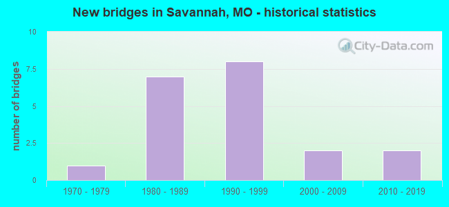
- New bridges - historical statistics
- 11970-1979
- 71980-1989
- 81990-1999
- 22000-2009
- 22010-2019


- Bridge Condition - Deck
- 7.7%Excellent
- 23.1%Very good
- 61.5%Good
- 7.7%Satisfactory

- Bridge Condition - Superstructure
- 15.4%Excellent
- 23.1%Very good
- 53.8%Good
- 7.7%Fair

- Bridge Condition - Substructure
- 30.8%Excellent
- 15.4%Very good
- 38.5%Good
- 15.4%Fair

- Bridge Condition - Channel
- 12.5%Very good
- 25.0%Good
- 25.0%Satisfactory
- 37.5%Fair
Find on map >> Show street view
Structure Number: 11776, Location: S 6 T 59 N R 35 W (Lat: 39.961711, Lng: -94.861164), Route carried "on" structure: US 71, Year Built: 1985, Status: Open, Structure Length: 4.97m (16.31ft), Average Daily Traffic: 4,498 (year 2021), Truck Traffic: 23%, Average Future Daily Traffic: 9,446 (year 2041), Design Load: HS 20+Mod, Features Intersected: US 59
Minimum Vertical Clearance: 30+ m (98+ ft), Kilometerpoint: 428.405, Lanes on structure: 2, Lanes under structure: 2, Base Highway Network: Yes, Owner: State Highway Agency, Approaching Roadway Width: 13.4m (44.0ft), Skew: 1 degrees, Material/Design: Prestressed concrete continuous, Design/Construction: Stringer/Multi-beam, Number Of Spans In Main Unit: 3, Length of Maximum Span: 26.8m (87.9ft), Curb or Sidewalk Widths: Left: 0.2m (0.7ft), Right: 0.2m (0.7ft), Curb-To-Curb Width: 13.0m (42.7ft), Out-to-Out Width: 13.9m (45.6ft)
Condition: Deck: Good, Superstructure: Good, Substructure: Excellent, Operating Rating: 59.4 metric tons, Method Used To Determine Operating Rating: Load Factor (LF), Inventory Rating: 36.9 metric tons, Method Used To Determine Inventory Rating: Load Factor (LF), Structural Evaluation: Better than present minimum criteria, Deck Geometry: Superior to present desirable criteria, Underclear: Better than present minimum criteria, Approach Roadway Alignment: Equal to present desirable criteria, Designated Inspection Frequency: Every 24 months, Inspection Date: September 2020, Deck Structure Type: Concrete Cast-file-Place, Wearing Surface/Protective System: Wearing Surface: Monolithic Concrete
Find on map >> Show street view
Structure Number: 11777, Location: S 20 T 59 N R 35 W (Lat: 39.922492, Lng: -94.860061), Route carried "on" structure: US 59, Year Built: 1985, Status: Open, Structure Length: 5.21m (17.09ft), Average Daily Traffic: 4,038 (year 2021), Truck Traffic: 30%, Average Future Daily Traffic: 8,480 (year 2041), Design Load: HS 20+Mod, Features Intersected: RT T
Minimum Vertical Clearance: 30+ m (98+ ft), Kilometerpoint: 57.581, Lanes on structure: 2, Lanes under structure: 2, Base Highway Network: Yes, Owner: State Highway Agency, Approaching Roadway Width: 13.4m (44.0ft), Skew: 1 degrees, Material/Design: Prestressed concrete continuous, Design/Construction: Stringer/Multi-beam, Number Of Spans In Main Unit: 3, Length of Maximum Span: 27.4m (89.9ft), Curb or Sidewalk Widths: Left: 0.2m (0.7ft), Right: 0.2m (0.7ft), Curb-To-Curb Width: 13.0m (42.7ft), Out-to-Out Width: 13.9m (45.6ft)
Condition: Deck: Good, Superstructure: Good, Substructure: Good, Operating Rating: 66.6 metric tons, Method Used To Determine Operating Rating: Load Factor (LF), Inventory Rating: 42.3 metric tons, Method Used To Determine Inventory Rating: Load Factor (LF), Structural Evaluation: Better than present minimum criteria, Deck Geometry: Superior to present desirable criteria, Underclear: Better than present minimum criteria, Approach Roadway Alignment: Equal to present desirable criteria, Designated Inspection Frequency: Every 24 months, Inspection Date: September 2020, Deck Structure Type: Concrete Cast-file-Place, Wearing Surface/Protective System: Wearing Surface: Monolithic Concrete, Deck Protection: Epoxy Coated Reinforcing
Find on map >> Show street view
Structure Number: 11821, Location: S 6 T 59 N R 35 W (Lat: 39.960603, Lng: -94.860858), Route carried "on" structure: US 71, Year Built: 1999, Status: Open, Structure Length: 5.09m (16.70ft), Average Daily Traffic: 4,081 (year 2021), Truck Traffic: 22%, Average Future Daily Traffic: 8,570 (year 2041), Design Load: HS 25 or greater, Features Intersected: US 59
Minimum Vertical Clearance: 30+ m (98+ ft), Kilometerpoint: 82.173, Lanes on structure: 2, Lanes under structure: 2, Base Highway Network: Yes, Owner: State Highway Agency, Approaching Roadway Width: 11.3m (37.1ft), Skew: 1 degrees, Material/Design: Prestressed concrete continuous, Design/Construction: Stringer/Multi-beam, Number Of Spans In Main Unit: 3, Length of Maximum Span: 26.9m (88.3ft), Curb or Sidewalk Widths: Left: 0.4m (1.3ft), Right: 0.4m (1.3ft), Curb-To-Curb Width: 11.4m (37.4ft), Out-to-Out Width: 12.2m (40.0ft)
Condition: Deck: Good, Superstructure: Good, Substructure: Good, Operating Rating: 84.6 metric tons, Method Used To Determine Operating Rating: Load Factor (LF), Inventory Rating: 50.4 metric tons, Method Used To Determine Inventory Rating: Load Factor (LF), Structural Evaluation: Better than present minimum criteria, Deck Geometry: Equal to present minimum criteria, Underclear: Better than present minimum criteria, Approach Roadway Alignment: Equal to present desirable criteria, Designated Inspection Frequency: Every 24 months, Inspection Date: September 2020, Deck Structure Type: Concrete Cast-file-Place, Wearing Surface/Protective System: Wearing Surface: Monolithic Concrete, Deck Protection: Epoxy Coated Reinforcing
Find on map >> Show street view
Structure Number: 11822, Location: S 20 T 59 N R 35 W (Lat: 39.922408, Lng: -94.860358), Route carried "on" structure: US 59, Year Built: 1999, Status: Open, Structure Length: 5.33m (17.49ft), Average Daily Traffic: 3,411 (year 2021), Truck Traffic: 21%, Average Future Daily Traffic: 7,163 (year 2041), Design Load: HS 20+Mod, Features Intersected: RT T
Minimum Vertical Clearance: 30+ m (98+ ft), Kilometerpoint: 114.640, Lanes on structure: 2, Lanes under structure: 2, Base Highway Network: Yes, Owner: State Highway Agency, Approaching Roadway Width: 11.3m (37.1ft), Skew: 1 degrees, Material/Design: Prestressed concrete continuous, Design/Construction: Stringer/Multi-beam, Number Of Spans In Main Unit: 3, Length of Maximum Span: 27.5m (90.2ft), Curb or Sidewalk Widths: Left: 0.4m (1.3ft), Right: 0.4m (1.3ft), Curb-To-Curb Width: 11.4m (37.4ft), Out-to-Out Width: 12.2m (40.0ft)
Condition: Deck: Very good, Superstructure: Very good, Substructure: Good, Operating Rating: 88.2 metric tons, Method Used To Determine Operating Rating: Load Factor (LF), Inventory Rating: 54.0 metric tons, Method Used To Determine Inventory Rating: Load Factor (LF), Structural Evaluation: Better than present minimum criteria, Deck Geometry: Equal to present minimum criteria, Underclear: Better than present minimum criteria, Approach Roadway Alignment: Equal to present desirable criteria, Designated Inspection Frequency: Every 24 months, Inspection Date: September 2020, Deck Structure Type: Concrete Cast-file-Place, Wearing Surface/Protective System: Wearing Surface: Monolithic Concrete, Deck Protection: Epoxy Coated Reinforcing
Find on map >> Show street view
Structure Number: 11833, Location: S 8 T 59 N R 35 W (Lat: 39.948208, Lng: -94.860319), Route carried "on" structure: US 59, Year Built: 1999, Status: Open, Structure Length: 3.57m (11.71ft), Average Daily Traffic: 3,411 (year 2021), Truck Traffic: 21%, Average Future Daily Traffic: 7,163 (year 2041), Design Load: HS 20+Mod, Features Intersected: CRD 427
Minimum Vertical Clearance: 30+ m (98+ ft), Kilometerpoint: 111.795, Lanes on structure: 2, Lanes under structure: 2, Base Highway Network: Yes, Owner: State Highway Agency, Approaching Roadway Width: 10.4m (34.1ft), Material/Design: Steel continuous, Design/Construction: Stringer/Multi-beam, Number Of Spans In Main Unit: 3, Length of Maximum Span: 14.4m (47.2ft), Curb-To-Curb Width: 11.4m (37.4ft), Out-to-Out Width: 12.2m (40.0ft)
Condition: Deck: Good, Superstructure: Very good, Substructure: Very good, Operating Rating: 83.7 metric tons, Method Used To Determine Operating Rating: Load Factor (LF), Inventory Rating: 50.4 metric tons, Method Used To Determine Inventory Rating: Load Factor (LF), Structural Evaluation: Equal to present desirable criteria, Deck Geometry: Equal to present minimum criteria, Underclear: Meets minimum limits, Approach Roadway Alignment: Equal to present desirable criteria, Designated Inspection Frequency: Every 24 months, Inspection Date: September 2020, Deck Structure Type: Concrete Cast-file-Place, Wearing Surface/Protective System: Wearing Surface: Monolithic Concrete, Deck Protection: Epoxy Coated Reinforcing
Find on map >> Show street view
Structure Number: 1857, Location: S 3 T 59 N R 35 W (Lat: 39.962200, Lng: -94.804089), Route carried "on" structure: County highway 190, Year Built: 1970, Status: Posted for load, Structure Length: 1.49m (4.89ft), Average Daily Traffic: 15 (year 2020), Truck Traffic: 10%, Average Future Daily Traffic: 17 (year 2040), Features Intersected: BR OF 102 RVR
Minimum Vertical Clearance: 30+ m (98+ ft), Kilometerpoint: 0.805, Lanes on structure: 1, Owner: County Highway Agency, Approaching Roadway Width: 3.7m (12.1ft), Material/Design: Steel, Design/Construction: Stringer/Multi-beam, Number Of Spans In Main Unit: 1, Number Of Approach Spans: 1, Length of Maximum Span: 10.4m (34.1ft), Curb-To-Curb Width: 4.6m (15.1ft), Out-to-Out Width: 5.0m (16.4ft)
Condition: Deck: Very good, Superstructure: Fair, Substructure: Fair, Channel: Fair, Operating Rating: 33.3 metric tons, Method Used To Determine Operating Rating: Allowable Stress (AS), Inventory Rating: 21.6 metric tons, Method Used To Determine Inventory Rating: Allowable Stress (AS), Structural Evaluation: Somewhat better than minimum adequacy, Deck Geometry: Better than present minimum criteria, Waterway Adequacy: Equal to present minimum criteria, Approach Roadway Alignment: High priority of corrective action, Length Of Structure Improvement: 0.22m (0.72ft), Designated Inspection Frequency: Every 24 months, Inspection Date: December 2021, Bridge Improvement Cost: $109,000, Roadway Improvement Cost: $11,000, Total Project Cost: $163,000 ( Estimate for 2022), Deck Structure Type: Wood or Timber, Wearing Surface/Protective System: Wearing Surface: Wood or Timber
Find on map >> Show street view
Structure Number: 23604, Location: S 18 T 59 N R 36 W (Lat: 39.930208, Lng: -94.868911), Route carried "on" structure: County highway 418, Year Built: 1991, Status: Open, Structure Length: 0.82m (2.69ft), Average Daily Traffic: 10 (year 2020), Truck Traffic: 10%, Average Future Daily Traffic: 12 (year 2040), Design Load: HS 20, Features Intersected: MACE CR
Minimum Vertical Clearance: 30+ m (98+ ft), Kilometerpoint: 4.023, Lanes on structure: 2, Owner: County Highway Agency, Approaching Roadway Width: 5.5m (18.0ft), Material/Design: Steel, Design/Construction: Stringer/Multi-beam, Number Of Spans In Main Unit: 1, Length of Maximum Span: 7.9m (25.9ft), Curb-To-Curb Width: 5.4m (17.7ft), Out-to-Out Width: 5.5m (18.0ft)
Condition: Deck: Good, Superstructure: Good, Substructure: Fair, Channel: Fair, Operating Rating: 89.1 metric tons, Method Used To Determine Operating Rating: Load Factor (LF), Inventory Rating: 53.1 metric tons, Method Used To Determine Inventory Rating: Load Factor (LF), Structural Evaluation: Somewhat better than minimum adequacy, Deck Geometry: High priority of corrective action, Waterway Adequacy: Superior to present desirable criteria, Approach Roadway Alignment: Equal to present desirable criteria, Designated Inspection Frequency: Every 24 months, Inspection Date: December 2021, Deck Structure Type: Concrete Cast-file-Place, Wearing Surface/Protective System: Wearing Surface: Monolithic Concrete
Find on map >> Show street view
Structure Number: 23671, Location: S 18 T 59 N R 35 W (Lat: 39.937344, Lng: -94.865100), Route carried "on" structure: County highway 423, Year Built: 1993, Status: Open, Structure Length: 0.91m (2.99ft), Average Daily Traffic: 20 (year 2020), Truck Traffic: 10%, Average Future Daily Traffic: 23 (year 2040), Design Load: HS 20, Features Intersected: BR OF MACE CR
Minimum Vertical Clearance: 30+ m (98+ ft), Kilometerpoint: 4.023, Lanes on structure: 2, Owner: County Highway Agency, Approaching Roadway Width: 5.5m (18.0ft), Material/Design: Steel, Design/Construction: Stringer/Multi-beam, Number Of Spans In Main Unit: 1, Length of Maximum Span: 8.8m (28.9ft), Curb-To-Curb Width: 5.3m (17.4ft), Out-to-Out Width: 5.5m (18.0ft)
Condition: Deck: Satisfactory, Superstructure: Good, Substructure: Good, Channel: Fair, Operating Rating: 89.1 metric tons, Method Used To Determine Operating Rating: Allowable Stress (AS), Inventory Rating: 53.1 metric tons, Method Used To Determine Inventory Rating: Allowable Stress (AS), Structural Evaluation: Better than present minimum criteria, Deck Geometry: High priority of corrective action, Waterway Adequacy: Equal to present desirable criteria, Approach Roadway Alignment: Equal to present minimum criteria, Designated Inspection Frequency: Every 24 months, Inspection Date: December 2021, Deck Structure Type: Concrete Cast-file-Place
Find on map >> Show street view
Structure Number: 2721, Location: S 8 T 59 N R 35 W (Lat: 39.948236, Lng: -94.859922), Route carried "on" structure: US 59, Year Built: 1985, Status: Open, Structure Length: 3.29m (10.79ft), Average Daily Traffic: 3,268 (year 2021), Truck Traffic: 21%, Average Future Daily Traffic: 6,863 (year 2041), Design Load: HS 20+Mod, Features Intersected: CRD 427
Minimum Vertical Clearance: 30+ m (98+ ft), Kilometerpoint: 60.444, Lanes on structure: 2, Lanes under structure: 2, Base Highway Network: Yes, Owner: State Highway Agency, Approaching Roadway Width: 13.4m (44.0ft), Material/Design: Prestressed concrete continuous, Design/Construction: Tee Beam, Number Of Spans In Main Unit: 3, Length of Maximum Span: 14.3m (46.9ft), Curb or Sidewalk Widths: Left: 0.2m (0.7ft), Right: 0.2m (0.7ft), Curb-To-Curb Width: 12.4m (40.7ft), Out-to-Out Width: 13.3m (43.6ft)
Condition: Deck: Good, Superstructure: Good, Substructure: Good, Operating Rating: 78.3 metric tons, Method Used To Determine Operating Rating: Load Factor (LF), Inventory Rating: 46.8 metric tons, Method Used To Determine Inventory Rating: Load Factor (LF), Structural Evaluation: Better than present minimum criteria, Deck Geometry: Better than present minimum criteria, Underclear: Somewhat better than minimum adequacy, Approach Roadway Alignment: Equal to present desirable criteria, Designated Inspection Frequency: Every 24 months, Inspection Date: September 2020, Deck Structure Type: Concrete Cast-file-Place, Wearing Surface/Protective System: Wearing Surface: Monolithic Concrete, Deck Protection: Epoxy Coated Reinforcing
Find on map >> Show street view
Structure Number: 2723, Location: S 29 T 59 N R 35 W (Lat: 39.906200, Lng: -94.858683), Route carried "on" structure: US 59, Year Built: 1985, Status: Open, Structure Length: 0.70m (2.30ft), Average Daily Traffic: 8,277 (year 2021), Truck Traffic: 24%, Average Future Daily Traffic: 17,382 (year 2041), Design Load: HS 20+Mod, Features Intersected: HOPKINS CR
Minimum Vertical Clearance: 30+ m (98+ ft), Kilometerpoint: 116.486, Lanes on structure: 4, Base Highway Network: Yes, Owner: State Highway Agency, Approaching Roadway Width: 24.7m (81.0ft), Material/Design: Concrete continuous, Design/Construction: Culvert, Number Of Spans In Main Unit: 2, Length of Maximum Span: 3.4m (11.2ft)
Condition: Channel: Satisfactory, Culverts: Satisfactory, Structural Evaluation: Equal to present minimum criteria, Waterway Adequacy: Superior to present desirable criteria, Approach Roadway Alignment: Equal to present desirable criteria, Designated Inspection Frequency: Every 24 months, Inspection Date: November 2020
Find on map >> Show street view
Structure Number: 2985, Location: S 12 T 59 N R 35 W (Lat: 39.942614, Lng: -94.771564), Route carried "on" structure: State highway E, Year Built: 2004, Status: Open, Structure Length: 11.09m (36.38ft), Average Daily Traffic: 2,026 (year 2021), Truck Traffic: 11%, Average Future Daily Traffic: 2,634 (year 2041), Design Load: HS 20+Mod, Features Intersected: HUNDRED & TWO RVR
Minimum Vertical Clearance: 30+ m (98+ ft), Kilometerpoint: 4.297, Lanes on structure: 2, Owner: State Highway Agency, Approaching Roadway Width: 8.5m (27.9ft), Skew: 3 degrees, Material/Design: Steel continuous, Design/Construction: Stringer/Multi-beam, Number Of Spans In Main Unit: 4, Length of Maximum Span: 39.6m (129.9ft), Curb-To-Curb Width: 12.2m (40.0ft), Out-to-Out Width: 13.0m (42.7ft)
Condition: Deck: Good, Superstructure: Excellent, Substructure: Very good, Channel: Satisfactory, Operating Rating: 65.7 metric tons, Method Used To Determine Operating Rating: Load Factor (LF), Inventory Rating: 39.6 metric tons, Method Used To Determine Inventory Rating: Load Factor (LF), Structural Evaluation: Equal to present desirable criteria, Deck Geometry: Equal to present minimum criteria, Waterway Adequacy: Superior to present desirable criteria, Approach Roadway Alignment: Equal to present desirable criteria, Designated Inspection Frequency: Every 24 months, Inspection Date: September 2020, Deck Structure Type: Concrete Cast-file-Place, Wearing Surface/Protective System: Wearing Surface: Monolithic Concrete, Deck Protection: Epoxy Coated Reinforcing
Find on map >> Show street view
Structure Number: 3176, Location: S 27 T 59 N R 35 W (Lat: 39.901133, Lng: -94.822667), Route carried "on" structure: County highway 365, Year Built: 2007, Status: Open, Structure Length: 2.38m (7.81ft), Average Daily Traffic: 5 (year 2020), Truck Traffic: 10%, Average Future Daily Traffic: 6 (year 2040), Design Load: HS 20+Mod, Features Intersected: DILLON CR
Minimum Vertical Clearance: 30+ m (98+ ft), Kilometerpoint: 0.805, Lanes on structure: 2, Owner: County Highway Agency, Approaching Roadway Width: 6.1m (20.0ft), Skew: 3 degrees, Material/Design: Steel, Design/Construction: Stringer/Multi-beam, Number Of Spans In Main Unit: 1, Length of Maximum Span: 22.9m (75.1ft), Curb-To-Curb Width: 7.3m (24.0ft), Out-to-Out Width: 8.1m (26.6ft)
Condition: Deck: Good, Superstructure: Very good, Substructure: Excellent, Channel: Good, Operating Rating: 73.8 metric tons, Method Used To Determine Operating Rating: Load Factor (LF), Inventory Rating: 44.1 metric tons, Method Used To Determine Inventory Rating: Load Factor (LF), Structural Evaluation: Equal to present desirable criteria, Deck Geometry: Equal to present minimum criteria, Waterway Adequacy: Superior to present desirable criteria, Approach Roadway Alignment: Equal to present minimum criteria, Designated Inspection Frequency: Every 24 months, Inspection Date: December 2021, Deck Structure Type: Concrete Cast-file-Place, Wearing Surface/Protective System: Wearing Surface: Monolithic Concrete
Find on map >> Show street view
Structure Number: 33548, Location: S 10 T 59 N R 35 W (Lat: 39.940181, Lng: -94.813631), Route carried "on" structure: City street 391, Year Built: 2011, Status: Open, Structure Length: 1.31m (4.30ft), Average Daily Traffic: 100 (year 2020), Truck Traffic: 10%, Average Future Daily Traffic: 120 (year 2040), Design Load: HS 20, Features Intersected: PLUCKUM CR, Facility Carried by Structure: SOUTH CEDAR ST.
Minimum Vertical Clearance: 30+ m (98+ ft), Kilometerpoint: 0.000, Lanes on structure: 2, Owner: City or Municipal Highway Agency, Approaching Roadway Width: 6.1m (20.0ft), Material/Design: Prestressed concrete, Design/Construction: Tee Beam, Number Of Spans In Main Unit: 1, Length of Maximum Span: 12.2m (40.0ft), Curb-To-Curb Width: 7.3m (24.0ft), Out-to-Out Width: 8.2m (26.9ft)
Condition: Deck: Very good, Superstructure: Good, Substructure: Excellent, Channel: Good, Operating Rating: 64.8 metric tons, Method Used To Determine Operating Rating: Load Factor (LF), Inventory Rating: 38.7 metric tons, Method Used To Determine Inventory Rating: Load Factor (LF), Structural Evaluation: Better than present minimum criteria, Deck Geometry: Equal to present minimum criteria, Waterway Adequacy: Superior to present desirable criteria, Approach Roadway Alignment: Equal to present desirable criteria, Designated Inspection Frequency: Every 24 months, Inspection Date: December 2021, Deck Structure Type: Concrete Precast Panels, Wearing Surface/Protective System: Wearing Surface: Monolithic Concrete
Find on map >> Show street view
Structure Number: 36223, Location: S 30 T 59 N R 35 W (Lat: 39.907075, Lng: -94.861550), Route carried "on" structure: County highway 368, Year Built: 2019, Status: Open, Structure Length: 1.58m (5.18ft), Average Daily Traffic: 10 (year 2020), Truck Traffic: 10%, Average Future Daily Traffic: 12 (year 2040), Design Load: HS 20, Features Intersected: HOPKINS CR
Minimum Vertical Clearance: 30+ m (98+ ft), Kilometerpoint: 0.161, Lanes on structure: 2, Owner: County Highway Agency, Approaching Roadway Width: 6.1m (20.0ft), Skew: 4 degrees, Material/Design: Concrete, Design/Construction: Box Beam or Girders - Single/Spread, Number Of Spans In Main Unit: 1, Length of Maximum Span: 13.9m (45.6ft), Curb-To-Curb Width: 7.8m (25.6ft), Out-to-Out Width: 8.7m (28.5ft)
Condition: Deck: Excellent, Superstructure: Excellent, Substructure: Excellent, Channel: Very good, Operating Rating: 54.0 metric tons, Method Used To Determine Operating Rating: Load Factor (LF), Inventory Rating: 32.4 metric tons, Method Used To Determine Inventory Rating: Load Factor (LF), Structural Evaluation: Equal to present desirable criteria, Deck Geometry: Equal to present minimum criteria, Waterway Adequacy: Superior to present desirable criteria, Approach Roadway Alignment: Equal to present desirable criteria, Designated Inspection Frequency: Every 24 months, Inspection Date: December 2021
Find on map >> Show street view
Structure Number: 11776, Location: S 6 T 59 N R 35 W (Lat: 39.961711, Lng: -94.861164), Route carried "under" structure: US 59, Year Built: 1985, Structure Length: 0. m, Average Daily Traffic: 2,141 (year 2021), Truck Traffic: 7%, Features Intersected: US 59, Facility Carried by Structure: US 71 N
Minimum Vertical Clearance: 4.85m (15.91ft), Kilometerpoint: 62.031, Lanes on structure: 2, Lanes under structure: 2, Material/Design: Prestressed concrete continuous, Design/Construction: Stringer/Multi-beam, Length of Maximum Span: 26.8m (87.9ft)
Find on map >> Show street view
Structure Number: 11777, Location: S 20 T 59 N R 35 W (Lat: 39.922492, Lng: -94.860061), Route carried "under" structure: State highway T, Year Built: 1985, Structure Length: 0. m, Average Daily Traffic: 1,907 (year 2021), Truck Traffic: 13%, Features Intersected: RT T, Facility Carried by Structure: US 59 N
Minimum Vertical Clearance: 4.98m (16.34ft), Kilometerpoint: 12.583, Lanes on structure: 2, Lanes under structure: 2, Material/Design: Prestressed concrete continuous, Design/Construction: Stringer/Multi-beam, Length of Maximum Span: 27.4m (89.9ft)
Find on map >> Show street view
Structure Number: 11821, Location: S 6 T 59 N R 35 W (Lat: 39.960603, Lng: -94.860858), Route carried "under" structure: US 59, Year Built: 1999, Structure Length: 0. m, Average Daily Traffic: 2,141 (year 2021), Truck Traffic: 7%, Features Intersected: US 59, Facility Carried by Structure: US 71 S
Minimum Vertical Clearance: 5.00m (16.40ft), Kilometerpoint: 62.056, Lanes on structure: 2, Lanes under structure: 2, Material/Design: Prestressed concrete continuous, Design/Construction: Stringer/Multi-beam, Length of Maximum Span: 26.9m (88.3ft)
Find on map >> Show street view
Structure Number: 11822, Location: S 20 T 59 N R 35 W (Lat: 39.922408, Lng: -94.860358), Route carried "under" structure: State highway T, Year Built: 1999, Structure Length: 0. m, Average Daily Traffic: 833 (year 2021), Truck Traffic: 13%, Features Intersected: RT T, Facility Carried by Structure: US 59 S
Minimum Vertical Clearance: 4.98m (16.34ft), Kilometerpoint: 12.558, Lanes on structure: 2, Lanes under structure: 2, Material/Design: Prestressed concrete continuous, Design/Construction: Stringer/Multi-beam, Length of Maximum Span: 27.5m (90.2ft)
Find on map >> Show street view
Structure Number: 11833, Location: S 8 T 59 N R 35 W (Lat: 39.948208, Lng: -94.860319), Route carried "under" structure: County highway 427, Year Built: 1999, Structure Length: 0. m, Average Daily Traffic: 116 (year 2021), Truck Traffic: 9%, Features Intersected: CRD 427, Facility Carried by Structure: US 59 S
Minimum Vertical Clearance: 4.47m (14.67ft), Kilometerpoint: 4.373, Lanes on structure: 2, Lanes under structure: 2, Material/Design: Steel continuous, Design/Construction: Stringer/Multi-beam, Length of Maximum Span: 14.4m (47.2ft)
Find on map >> Show street view
Structure Number: 2721, Location: S 8 T 59 N R 35 W (Lat: 39.948236, Lng: -94.859922), Route carried "under" structure: County highway 427, Year Built: 1985, Structure Length: 0. m, Average Daily Traffic: 116 (year 2021), Truck Traffic: 9%, Features Intersected: CRD 427, Facility Carried by Structure: US 59 N
Minimum Vertical Clearance: 4.75m (15.58ft), Kilometerpoint: 4.406, Lanes on structure: 2, Lanes under structure: 2, Material/Design: Prestressed concrete continuous, Design/Construction: Tee Beam, Length of Maximum Span: 14.3m (46.9ft)