Bridge Statistics for Scarborough, Maine (ME)
Condition, Traffic, Stress, Structural Evaluation, Project Costs
- National Bridge Inventory (NBI) Statistics
- 14Number of bridges
- 59ft / 17.5mTotal length
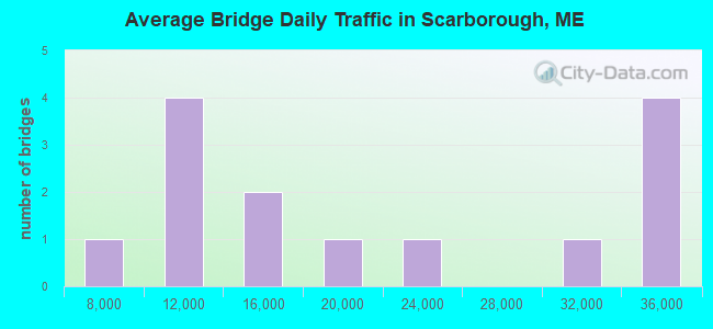
- 284,256Total average daily traffic
- 25,071Total average daily truck traffic
- National Bridge Inventory (NBI) Registered Bridges for Scarborough
- No street view available for this location
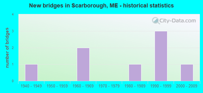
- New bridges - historical statistics
- 11940-1949
- 21960-1969
- 11980-1989
- 31990-1999
- 12000-2009
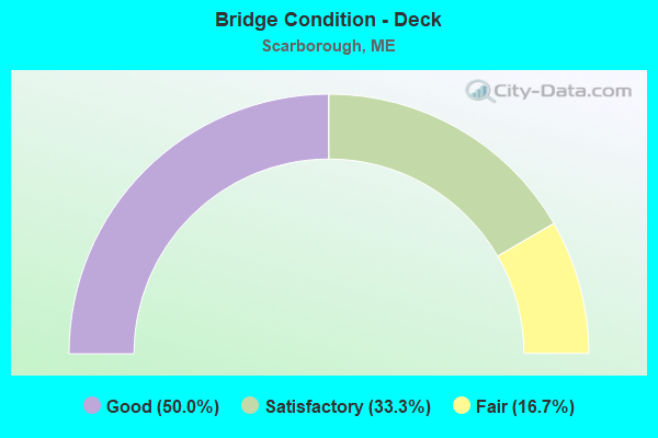
- Bridge Condition - Deck
- 50.0%Good
- 33.3%Satisfactory
- 16.7%Fair
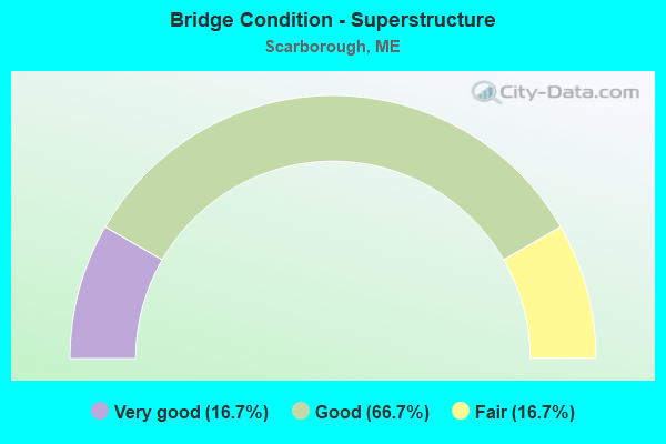
- Bridge Condition - Superstructure
- 16.7%Very good
- 66.7%Good
- 16.7%Fair
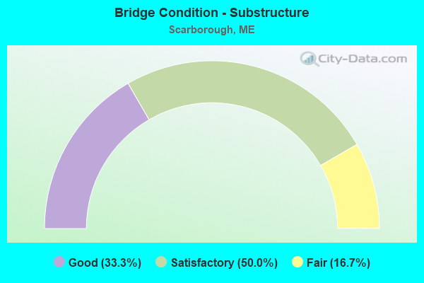
- Bridge Condition - Substructure
- 33.3%Good
- 50.0%Satisfactory
- 16.7%Fair
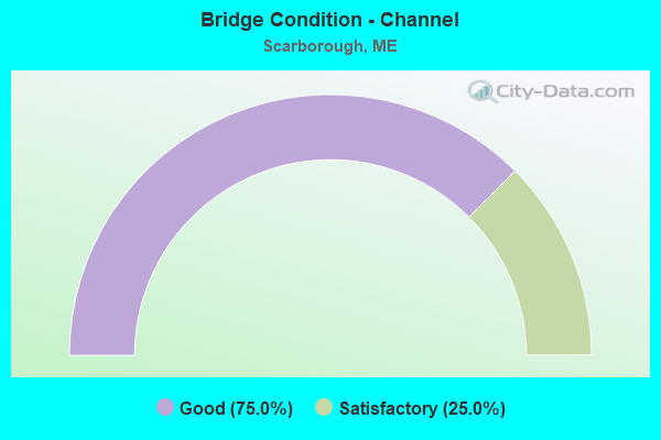
- Bridge Condition - Channel
- 75.0%Good
- 25.0%Satisfactory
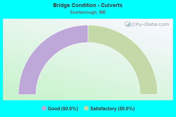
- Bridge Condition - Culverts
- 50.0%Good
- 50.0%Satisfactory
Find on map >> Show street view
Structure Number: 224, Location: 0.7 MI NE RTE 9 JCT US1 (Lat: 43.578061, Lng: -70.373900), Route carried "on" structure: State highway 1, Year Built: 2004, Status: Open, Structure Length: 1.35m (4.43ft), Average Daily Traffic: 22,357 (year 2016), Truck Traffic: 5%, Average Future Daily Traffic: 31,300 (year 2036), Design Load: HS 25 or greater, Features Intersected: DUNSTAN RIVER
Minimum Vertical Clearance: 30+ m (98+ ft), Kilometerpoint: 66.852, Lanes on structure: 4, Base Highway Network: Yes, Owner: State Highway Agency, Approaching Roadway Width: 19.1m (62.7ft), Design/Construction: Culvert, Number Of Spans In Main Unit: 4, Length of Maximum Span: 2.4m (7.9ft)
Condition: Channel: Good, Culverts: Good, Operating Rating: 97.2 metric tons, Method Used To Determine Operating Rating: Load and Resistance Factor Rating (LRFR) rating reported by rating factor(RF) method using HL-93 loadings, Inventory Rating: 97.2 metric tons, Method Used To Determine Inventory Rating: Load and Resistance Factor Rating (LRFR) rating reported by rating factor(RF) method using HL-93 loadings, Structural Evaluation: Better than present minimum criteria, Waterway Adequacy: Somewhat better than minimum adequacy, Approach Roadway Alignment: Equal to present desirable criteria, Designated Inspection Frequency: Every 24 months, Underwater Inspection Frequency: Every 60 months, Inspection Date: November 2020, Underwater Inspection Date: August 2020
Find on map >> Show street view
Structure Number: 2671, Location: .3 MI S TOWNLINE (Lat: 43.609131, Lng: -70.313581), Route carried "on" structure: State highway 1, Year Built: 1986, Status: Open, Structure Length: 0.85m (2.79ft), Average Daily Traffic: 11,598 (year 2016), Truck Traffic: 5%, Average Future Daily Traffic: 16,237 (year 2036), Design Load: HS 25 or greater, Features Intersected: NONESUCH RIVER
Minimum Vertical Clearance: 30+ m (98+ ft), Kilometerpoint: 73.145, Lanes on structure: 5, Base Highway Network: Yes, Owner: State Highway Agency, Approaching Roadway Width: 22.6m (74.1ft), Skew: 1 degrees, Material/Design: Concrete, Design/Construction: Slab, Number Of Spans In Main Unit: 1, Length of Maximum Span: 7.6m (24.9ft), Curb-To-Curb Width: 22.0m (72.2ft), Out-to-Out Width: 23.2m (76.1ft)
Condition: Deck: Good, Superstructure: Good, Substructure: Satisfactory, Channel: Good, Operating Rating: 19.8 metric tons, Method Used To Determine Operating Rating: Load and Resistance Factor Rating (LRFR) rating reported by rating factor(RF) method using HL-93 loadings, Inventory Rating: 15.2 metric tons, Method Used To Determine Inventory Rating: Load and Resistance Factor Rating (LRFR) rating reported by rating factor(RF) method using HL-93 loadings, Structural Evaluation: High priority of corrective action, Deck Geometry: Somewhat better than minimum adequacy, Waterway Adequacy: Better than present minimum criteria, Approach Roadway Alignment: Equal to present desirable criteria, Designated Inspection Frequency: Every 24 months, Inspection Date: November 2020, Deck Structure Type: Concrete Cast-file-Place, Wearing Surface/Protective System: Wearing Surface: Bituminous, Membrane: Other
Find on map >> Show street view
Structure Number: 3911, Location: 0.8 MI S JCT US 1 (Lat: 43.602911, Lng: -70.301939), Route carried "on" structure: County highway , Year Built: 1998, Status: Open, Structure Length: 2.32m (7.61ft), Average Daily Traffic: 11,580 (year 2016), Truck Traffic: 5%, Average Future Daily Traffic: 16,212 (year 2036), Design Load: HS 25 or greater, Features Intersected: BOSTON & MAINE RR, Facility Carried by Structure: PLEASANT HILL ROAD
Minimum Vertical Clearance: 30+ m (98+ ft), Kilometerpoint: 1.320, Lanes on structure: 2, Owner: State Highway Agency, Approaching Roadway Width: 10.4m (34.1ft), Skew: 2 degrees, Material/Design: Steel, Design/Construction: Stringer/Multi-beam, Number Of Spans In Main Unit: 1, Length of Maximum Span: 22.6m (74.1ft), Curb or Sidewalk Widths: Left: 0.1m (0.3ft), Right: 0.1m (0.3ft), Curb-To-Curb Width: 10.4m (34.1ft), Out-to-Out Width: 11.2m (36.7ft)
Condition: Deck: Good, Superstructure: Very good, Substructure: Good, Operating Rating: 41.8 metric tons, Method Used To Determine Operating Rating: Load and Resistance Factor Rating (LRFR) rating reported by rating factor(RF) method using HL-93 loadings, Inventory Rating: 32.4 metric tons, Method Used To Determine Inventory Rating: Load and Resistance Factor Rating (LRFR) rating reported by rating factor(RF) method using HL-93 loadings, Structural Evaluation: Better than present minimum criteria, Deck Geometry: Meets minimum limits, Underclear: Equal to present minimum criteria, Approach Roadway Alignment: Better than present minimum criteria, Designated Inspection Frequency: Every 24 months, Inspection Date: April 2021, Deck Structure Type: Concrete Cast-file-Place, Wearing Surface/Protective System: Wearing Surface: Bituminous, Membrane: Preformed Fabric
Find on map >> Show street view
Structure Number: 3944, Location: 0.4 MI SW JCT RTE 114 (Lat: 43.616139, Lng: -70.355189), Route carried "on" structure: County highway , Year Built: 1946, Status: Open, Structure Length: 0.69m (2.26ft), Average Daily Traffic: 16,250 (year 2016), Truck Traffic: 5%, Average Future Daily Traffic: 22,750 (year 2036), Design Load: H 15, Features Intersected: NONESUCH RIVER, Facility Carried by Structure: PAYNE ROAD
Minimum Vertical Clearance: 30+ m (98+ ft), Kilometerpoint: 4.088, Lanes on structure: 2, Owner: State Highway Agency, Approaching Roadway Width: 11.0m (36.1ft), Material/Design: Concrete, Design/Construction: Frame, Number Of Spans In Main Unit: 1, Length of Maximum Span: 6.1m (20.0ft), Curb-To-Curb Width: 7.3m (24.0ft), Out-to-Out Width: 8.4m (27.6ft)
Condition: Deck: Fair, Superstructure: Fair, Substructure: Fair, Channel: Satisfactory, Operating Rating: 34.3 metric tons, Method Used To Determine Operating Rating: Load and Resistance Factor Rating (LRFR) rating reported by rating factor(RF) method using HL-93 loadings, Inventory Rating: 26.6 metric tons, Method Used To Determine Inventory Rating: Load and Resistance Factor Rating (LRFR) rating reported by rating factor(RF) method using HL-93 loadings, Structural Evaluation: Somewhat better than minimum adequacy, Deck Geometry: High priority of replacement, Waterway Adequacy: Equal to present minimum criteria, Approach Roadway Alignment: Equal to present desirable criteria, Designated Inspection Frequency: Every 24 months, Inspection Date: December 2021, Deck Structure Type: Concrete Cast-file-Place, Wearing Surface/Protective System: Wearing Surface: Bituminous
Find on map >> Show street view
Structure Number: 5293, Location: 1.2 MI S JCT US1 & 9 (Lat: 43.578039, Lng: -70.322600), Route carried "on" structure: County highway 207, Year Built: 1996, Status: Open, Structure Length: 1.62m (5.31ft), Average Daily Traffic: 14,080 (year 2016), Truck Traffic: 5%, Average Future Daily Traffic: 19,712 (year 2036), Design Load: HS 25 or greater, Features Intersected: BOSTON AND MAINE RR
Minimum Vertical Clearance: 30+ m (98+ ft), Kilometerpoint: 1.867, Lanes on structure: 3, Owner: Railroad, Maintenance Responsibility: State Highway Agency, Approaching Roadway Width: 10.4m (34.1ft), Skew: 1 degrees, Material/Design: Prestressed concrete, Design/Construction: Box Beam or Girders - Multiple, Number Of Spans In Main Unit: 1, Length of Maximum Span: 15.2m (49.9ft), Curb or Sidewalk Widths: Left: 0.4m (1.3ft), Right: 0.4m (1.3ft), Curb-To-Curb Width: 10.2m (33.5ft), Out-to-Out Width: 10.9m (35.8ft)
Condition: Deck: Good, Superstructure: Good, Substructure: Good, Operating Rating: 43.7 metric tons, Method Used To Determine Operating Rating: Load and Resistance Factor Rating (LRFR) rating reported by rating factor(RF) method using HL-93 loadings, Inventory Rating: 33.7 metric tons, Method Used To Determine Inventory Rating: Load and Resistance Factor Rating (LRFR) rating reported by rating factor(RF) method using HL-93 loadings, Structural Evaluation: Better than present minimum criteria, Deck Geometry: High priority of replacement, Underclear: Somewhat better than minimum adequacy, Approach Roadway Alignment: Equal to present desirable criteria, Designated Inspection Frequency: Every 24 months, Inspection Date: April 2021, Deck Structure Type: Concrete Cast-file-Place, Wearing Surface/Protective System: Wearing Surface: Bituminous, Membrane: Built-up
Find on map >> Show street view
Structure Number: 6201, Location: 0.5 MI N US 1 (Lat: 43.611711, Lng: -70.320500), Route carried "on" structure: State highway 701, Year Built: 1968, Status: Open, Structure Length: 0.70m (2.30ft), Average Daily Traffic: 9,410 (year 2016), Truck Traffic: 7%, Average Future Daily Traffic: 13,174 (year 2036), Design Load: HS 20+Mod, Features Intersected: NONESUCH RIVER, Facility Carried by Structure: RTE 1 CONNECTOR
Minimum Vertical Clearance: 30+ m (98+ ft), Kilometerpoint: 1.078, Lanes on structure: 4, Base Highway Network: Yes, Owner: State Highway Agency, Approaching Roadway Width: 11.6m (38.1ft), Skew: 20 degrees, Material/Design: Concrete, Design/Construction: Culvert, Number Of Spans In Main Unit: 1, Length of Maximum Span: 6.1m (20.0ft)
Condition: Channel: Good, Culverts: Satisfactory, Operating Rating: 42.1 metric tons, Method Used To Determine Operating Rating: Assigned ratings based on Load and Resistance Factor Design (LRFD) reported by rating factor (RF) using HL93 loadings, Inventory Rating: 32.4 metric tons, Method Used To Determine Inventory Rating: Assigned ratings based on Load and Resistance Factor Design (LRFD) reported by rating factor (RF) using HL93 loadings, Structural Evaluation: Equal to present minimum criteria, Waterway Adequacy: Equal to present desirable criteria, Approach Roadway Alignment: Equal to present desirable criteria, Designated Inspection Frequency: Every 24 months, Underwater Inspection Frequency: Every 60 months, Inspection Date: September 2021, Underwater Inspection Date: September 2021
Find on map >> Show street view
Structure Number: 6202, Location: 0.25 MI NE US 1 SPLITS (Lat: 43.603931, Lng: -70.318381), Route carried "on" structure: State highway 701, Year Built: 1968, Status: Open, Structure Length: 3.60m (11.81ft), Average Daily Traffic: 9,410 (year 2016), Truck Traffic: 7%, Average Future Daily Traffic: 13,174 (year 2036), Design Load: HS 20+Mod, Features Intersected: US 1 SOUTHBOUND, Facility Carried by Structure: NB ROUTE 1 CONNEC
Minimum Vertical Clearance: 30+ m (98+ ft), Kilometerpoint: 0.193, Lanes on structure: 2, Lanes under structure: 1, Base Highway Network: Yes, Owner: State Highway Agency, Approaching Roadway Width: 12.2m (40.0ft), Skew: 4 degrees, Material/Design: Steel, Design/Construction: Stringer/Multi-beam, Number Of Spans In Main Unit: 1, Length of Maximum Span: 35.1m (115.2ft), Curb or Sidewalk Widths: Left: 0.2m (0.7ft), Right: 0.2m (0.7ft), Curb-To-Curb Width: 12.0m (39.4ft), Out-to-Out Width: 13.1m (43.0ft)
Condition: Deck: Satisfactory, Superstructure: Good, Substructure: Satisfactory, Operating Rating: 49.2 metric tons, Method Used To Determine Operating Rating: Load and Resistance Factor Rating (LRFR) rating reported by rating factor(RF) method using HL-93 loadings, Inventory Rating: 37.9 metric tons, Method Used To Determine Inventory Rating: Load and Resistance Factor Rating (LRFR) rating reported by rating factor(RF) method using HL-93 loadings, Structural Evaluation: Equal to present minimum criteria, Deck Geometry: Equal to present minimum criteria, Underclear: Meets minimum limits, Approach Roadway Alignment: Better than present minimum criteria, Designated Inspection Frequency: Every 24 months, Inspection Date: July 2021, Deck Structure Type: Concrete Cast-file-Place, Wearing Surface/Protective System: Wearing Surface: Bituminous, Membrane: Preformed Fabric
Find on map >> Show street view
Structure Number: 6357, Location: 0.333 mi NW of Payne Rd (Lat: 43.605069, Lng: -70.372439), Route carried "on" structure: Ramp Other road , Year Built: 1992, Status: Open, Structure Length: 6.40m (21.00ft), Average Daily Traffic: 6,660 (year 2016), Truck Traffic: 10%, Average Future Daily Traffic: 9,324 (year 2036), Design Load: HL 93, Features Intersected: I-95, Facility Carried by Structure: SCARBOROUGH INTER
Minimum Vertical Clearance: 30+ m (98+ ft), Kilometerpoint: 0.354, Lanes on structure: 2, Lanes under structure: 7, Toll: On Interstate toll segment, Owner: State Toll Authority, Approaching Roadway Width: 12.2m (40.0ft), Skew: 31 degrees, Material/Design: Steel continuous, Design/Construction: Stringer/Multi-beam, Number Of Spans In Main Unit: 2, Length of Maximum Span: 35.1m (115.2ft), Curb or Sidewalk Widths: Left: 0.2m (0.7ft), Right: 0.2m (0.7ft), Curb-To-Curb Width: 12.2m (40.0ft), Out-to-Out Width: 13.9m (45.6ft)
Condition: Deck: Satisfactory, Superstructure: Good, Substructure: Satisfactory, Operating Rating: 41.1 metric tons, Method Used To Determine Operating Rating: Load and Resistance Factor Rating (LRFR) rating reported by rating factor(RF) method using HL-93 loadings, Inventory Rating: 31.8 metric tons, Method Used To Determine Inventory Rating: Load and Resistance Factor Rating (LRFR) rating reported by rating factor(RF) method using HL-93 loadings, Structural Evaluation: Equal to present minimum criteria, Deck Geometry: Superior to present desirable criteria, Underclear: Equal to present minimum criteria, Approach Roadway Alignment: Better than present minimum criteria, Designated Inspection Frequency: Every 24 months, Inspection Date: April 2021, Deck Structure Type: Concrete Cast-file-Place, Wearing Surface/Protective System: Wearing Surface: Bituminous, Membrane: Preformed Fabric, Deck Protection: Epoxy Coated Reinforcing
Find on map >> Show street view
Location: 0.495 mi W of Payne Rd (Lat: 43.591300, Lng: -70.385253), Route carried "under" structure: Business US 92110, Structure Length: 0. m, Average Daily Traffic: 34,920 (year 2014), Truck Traffic: 11%, Features Intersected: BEECH RIDGE ROAD, Facility Carried by Structure: I-95
Minimum Vertical Clearance: 5.03m (16.50ft), Kilometerpoint: 65.532, Lanes on structure: 6, Toll: On Interstate toll segment, Length of Maximum Span: 0.0m
Find on map >> Show street view
Location: 0.441 mi W of Payne RD (Lat: 43.599400, Lng: -70.377989), Route carried "under" structure: Ramp US 2110, Structure Length: 0. m, Average Daily Traffic: 34,920 (year 2014), Truck Traffic: 11%, Features Intersected: TWO ROD ROAD, Facility Carried by Structure: I-95
Minimum Vertical Clearance: 5.03m (16.50ft), Kilometerpoint: 66.659, Lanes on structure: 6, Toll: On Interstate toll segment, Length of Maximum Span: 0.0m
Find on map >> Show street view
Location: 0.287 mi NW of Payne Rd (Lat: 43.610308, Lng: -70.366947), Route carried "under" structure: Ramp US 12110, Structure Length: 0. m, Average Daily Traffic: 33,970 (year 2014), Truck Traffic: 11%, Features Intersected: HOLMES ROAD, Facility Carried by Structure: I-95
Minimum Vertical Clearance: 5.03m (16.50ft), Kilometerpoint: 68.301, Lanes on structure: 6, Toll: On Interstate toll segment, Length of Maximum Span: 0.0m
Find on map >> Show street view
Location: 0.297 mi NW of Payne Rd (Lat: 43.622244, Lng: -70.356414), Route carried "under" structure: State highway 12310, Structure Length: 0. m, Average Daily Traffic: 13,651 (year 2014), Truck Traffic: 5%, Features Intersected: GORHAM RD/RTE 114, Facility Carried by Structure: (OVER) I-295 SB RA
Minimum Vertical Clearance: 6.04m (19.82ft), Kilometerpoint: 4.313, Lanes on structure: 2, Length of Maximum Span: 0.0m
Find on map >> Show street view
Location: 0.207 mi NW of Payne Rd (Lat: 43.621992, Lng: -70.354597), Route carried "under" structure: State highway 22110, Structure Length: 0. m, Average Daily Traffic: 33,970 (year 2014), Truck Traffic: 11%, Features Intersected: GORHAM RD/RTE 114, Facility Carried by Structure: I-95
Minimum Vertical Clearance: 4.93m (16.17ft), Kilometerpoint: 69.813, Lanes on structure: 5, Toll: On Interstate toll segment, Length of Maximum Span: 0.0m
Find on map >> Show street view
Location: 0.333 mi NW of Payne Rd (Lat: 43.605064, Lng: -70.372436), Route carried "under" structure: State highway 72110, Structure Length: 0. m, Average Daily Traffic: 31,480 (year 2014), Truck Traffic: 11%, Features Intersected: SCARBOROUGH INTER, Facility Carried by Structure: I-95
Minimum Vertical Clearance: 5.03m (16.50ft), Kilometerpoint: 67.544, Lanes on structure: 5, Toll: On Interstate toll segment, Length of Maximum Span: 0.0m