Bridge Statistics for Scarsdale, New York (NY)
Condition, Traffic, Stress, Structural Evaluation, Project Costs
- National Bridge Inventory (NBI) Statistics
- 22Number of bridges
- 112ft / 34.1mTotal length
- $53,513,000Total costs
- 231,265Total average daily traffic
- 1,921Total average daily truck traffic
- National Bridge Inventory (NBI) Registered Bridges for Scarsdale
- No street view available for this location
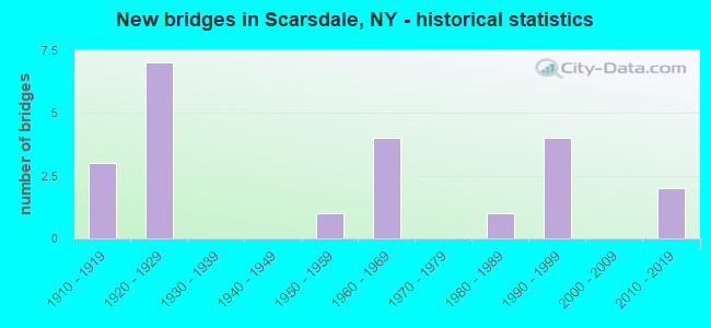
- New bridges - historical statistics
- 31910-1919
- 71920-1929
- 11950-1959
- 41960-1969
- 11980-1989
- 41990-1999
- 22010-2019
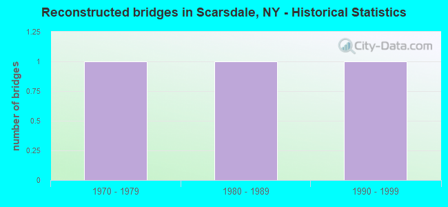
- Reconstructed bridges - Historical Statistics
- 11970-1979
- 11980-1989
- 11990-1999
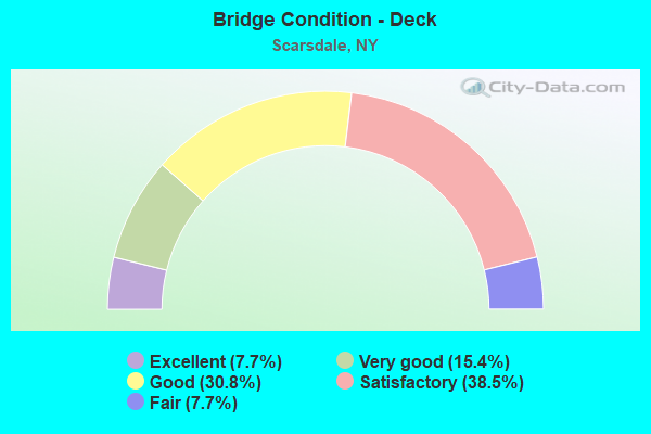
- Bridge Condition - Deck
- 7.7%Excellent
- 15.4%Very good
- 30.8%Good
- 38.5%Satisfactory
- 7.7%Fair
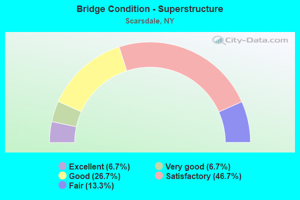
- Bridge Condition - Superstructure
- 6.7%Excellent
- 6.7%Very good
- 26.7%Good
- 46.7%Satisfactory
- 13.3%Fair
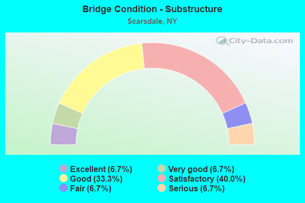
- Bridge Condition - Substructure
- 6.7%Excellent
- 6.7%Very good
- 33.3%Good
- 40.0%Satisfactory
- 6.7%Fair
- 6.7%Serious
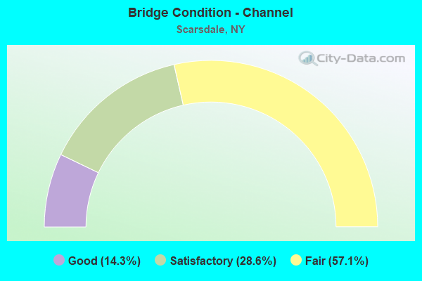
- Bridge Condition - Channel
- 14.3%Good
- 28.6%Satisfactory
- 57.1%Fair
Find on map >> Show street view
Structure Number: 22623, Location: 1.4 MI NW OF MAMARONECK (Lat: 40.957156, Lng: -73.759683), Route carried "on" structure: Other road , Year Built: 1920, Status: Open, Structure Length: 0.76m (2.49ft), Average Daily Traffic: 5,806 (year 2018), Truck Traffic: 4%, Average Future Daily Traffic: 7,183 (year 2040), Features Intersected: WINDING BROOK, Facility Carried by Structure: FENIMORE ROAD
Minimum Vertical Clearance: 30+ m (98+ ft), Kilometerpoint: 1.255, Lanes on structure: 2, Owner: Town or Township Highway Agency, Approaching Roadway Width: 8.5m (27.9ft), Skew: 2 degrees, Material/Design: Steel, Design/Construction: Stringer/Multi-beam, Number Of Spans In Main Unit: 1, Length of Maximum Span: 6.4m (21.0ft), Curb-To-Curb Width: 9.1m (29.9ft), Out-to-Out Width: 10.4m (34.1ft)
Condition: Deck: Good, Superstructure: Satisfactory, Substructure: Good, Channel: Fair, Operating Rating: 96.9 metric tons, Method Used To Determine Operating Rating: Load and Resistance Factor Rating (LRFR) rating reported by rating factor(RF) method using HL-93 loadings, Inventory Rating: 74.8 metric tons, Method Used To Determine Inventory Rating: Load and Resistance Factor Rating (LRFR) rating reported by rating factor(RF) method using HL-93 loadings, Structural Evaluation: Equal to present minimum criteria, Deck Geometry: High priority of corrective action, Waterway Adequacy: Meets minimum limits, Approach Roadway Alignment: Equal to present desirable criteria, Length Of Structure Improvement: 0.76m (2.49ft), Designated Inspection Frequency: Every 24 months, Inspection Date: May 2021, Bridge Improvement Cost: $1,909,000, Roadway Improvement Cost: $1,118,000, Total Project Cost: $3,026,000 ( Estimate for 2021), Deck Structure Type: Concrete Cast-file-Place, Wearing Surface/Protective System: Wearing Surface: Bituminous
Find on map >> Show street view
Structure Number: 22653, Location: 3.1 MI NE OF TUCKAHOE (Lat: 40.985069, Lng: -73.775428), Route carried "on" structure: City street , Year Built: 1910, Year Reconstructed: 1991, Status: Posted for load, Structure Length: 4.48m (14.70ft), Average Daily Traffic: 7,821 (year 2018), Truck Traffic: 2%, Average Future Daily Traffic: 7,857 (year 2040), Design Load: HS 20, Features Intersected: HEATHCOTE BYPASS, Facility Carried by Structure: HEATHCOTE ROAD
Minimum Vertical Clearance: 30+ m (98+ ft), Kilometerpoint: 2.172, Lanes on structure: 3, Lanes under structure: 2, Owner: Town or Township Highway Agency, Approaching Roadway Width: 11.9m (39.0ft), Skew: 4 degrees, Material/Design: Steel continuous, Design/Construction: Stringer/Multi-beam, Number Of Spans In Main Unit: 3, Length of Maximum Span: 18.2m (59.7ft), Curb or Sidewalk Widths: Left: 2.1m (6.9ft), Right: 2.1m (6.9ft), Curb-To-Curb Width: 11.8m (38.7ft), Out-to-Out Width: 16.8m (55.1ft)
Condition: Deck: Satisfactory, Superstructure: Fair, Substructure: Serious, Operating Rating: 58.1 metric tons, Method Used To Determine Operating Rating: Load Factor (LF), Inventory Rating: 34.5 metric tons, Method Used To Determine Inventory Rating: Load Factor (LF), Structural Evaluation: High priority of corrective action, Deck Geometry: High priority of corrective action, Underclear: Meets minimum limits, Approach Roadway Alignment: Equal to present desirable criteria, Bridge Posting: Required (Relationship of Operating Rating to Maximum Legal Load: > 39.9% below), Length Of Structure Improvement: 4.48m (14.70ft), Designated Inspection Frequency: Every 12 months, Critical Feature Inspection Frequency: Every 12 months, Inspection Date: May 2021, Critical Feature Inspection Date: May 2021, Bridge Improvement Cost: $5,158,000, Roadway Improvement Cost: $3,020,000, Total Project Cost: $8,178,000 ( Estimate for 2021), Deck Structure Type: Concrete Cast-file-Place, Wearing Surface/Protective System: Wearing Surface: Monolithic Concrete, Deck Protection: Epoxy Coated Reinforcing
Find on map >> Show street view
Structure Number: 226531, Location: 3.5 NE OF TUCKAHOE (Lat: 40.990658, Lng: -73.769742), Route carried "on" structure: Other road , Year Built: 1992, Status: Open, Structure Length: 3.60m (11.81ft), Average Daily Traffic: 6,535 (year 2018), Truck Traffic: 3%, Average Future Daily Traffic: 7,938 (year 2040), Design Load: HS 20, Features Intersected: HEATHCOTE BYPASS, Facility Carried by Structure: MAMARONECK ROAD
Minimum Vertical Clearance: 30+ m (98+ ft), Kilometerpoint: 2.204, Lanes on structure: 2, Lanes under structure: 2, Owner: Town or Township Highway Agency, Approaching Roadway Width: 8.5m (27.9ft), Skew: 3 degrees, Material/Design: Steel, Design/Construction: Stringer/Multi-beam, Number Of Spans In Main Unit: 1, Length of Maximum Span: 35.0m (114.8ft), Curb or Sidewalk Widths: Left: 1.5m (4.9ft), Right: 0.0m, Curb-To-Curb Width: 8.5m (27.9ft), Out-to-Out Width: 10.8m (35.4ft)
Condition: Deck: Very good, Superstructure: Good, Substructure: Good, Operating Rating: 58.0 metric tons, Method Used To Determine Operating Rating: Load and Resistance Factor Rating (LRFR) rating reported by rating factor(RF) method using HL-93 loadings, Inventory Rating: 44.7 metric tons, Method Used To Determine Inventory Rating: Load and Resistance Factor Rating (LRFR) rating reported by rating factor(RF) method using HL-93 loadings, Structural Evaluation: Better than present minimum criteria, Deck Geometry: High priority of replacement, Underclear: Meets minimum limits, Approach Roadway Alignment: Equal to present desirable criteria, Length Of Structure Improvement: 3.59m (11.78ft), Designated Inspection Frequency: Every 24 months, Inspection Date: April 2021, Bridge Improvement Cost: $1,833,000, Roadway Improvement Cost: $1,074,000, Total Project Cost: $2,907,000 ( Estimate for 2021), Deck Structure Type: Concrete Cast-file-Place, Wearing Surface/Protective System: Wearing Surface: Integral Concrete, Deck Protection: Epoxy Coated Reinforcing
Find on map >> Show street view
Structure Number: 226534, Location: 2.5 MILES N OF TUCKAHOE (Lat: 40.988772, Lng: -73.808675), Route carried "on" structure: County highway , Year Built: 2012, Status: Open, Structure Length: 2.06m (6.76ft), Average Daily Traffic: 10,059 (year 2018), Truck Traffic: 2%, Average Future Daily Traffic: 10,106 (year 2040), Design Load: HS 25 or greater, Features Intersected: MNRR HA LINE, Facility Carried by Structure: POPHAM ROAD
Minimum Vertical Clearance: 30+ m (98+ ft), Kilometerpoint: 0.080, Lanes on structure: 5, Owner: Railroad, Approaching Roadway Width: 17.4m (57.1ft), Skew: 30 degrees, Material/Design: Steel, Design/Construction: Stringer/Multi-beam, Number Of Spans In Main Unit: 1, Length of Maximum Span: 19.8m (65.0ft), Curb or Sidewalk Widths: Left: 3.0m (9.8ft), Right: 3.0m (9.8ft), Curb-To-Curb Width: 17.4m (57.1ft), Out-to-Out Width: 25.0m (82.0ft)
Condition: Deck: Good, Superstructure: Very good, Substructure: Very good, Operating Rating: 88.0 metric tons, Method Used To Determine Operating Rating: Allowable Stress (AS), Inventory Rating: 48.1 metric tons, Method Used To Determine Inventory Rating: Allowable Stress (AS), Structural Evaluation: Equal to present desirable criteria, Deck Geometry: High priority of replacement, Underclear: High priority of corrective action, Approach Roadway Alignment: Meets minimum limits, Length Of Structure Improvement: 2.06m (6.76ft), Designated Inspection Frequency: Every 24 months, Inspection Date: September 2020, Bridge Improvement Cost: $4,081,000, Roadway Improvement Cost: $2,390,000, Total Project Cost: $6,471,000 ( Estimate for 2021), Deck Structure Type: Concrete Cast-file-Place, Wearing Surface/Protective System: Wearing Surface: Integral Concrete
Find on map >> Show street view
Structure Number: 226712, Location: 1.2 MI SW OF WHITE PLAINS (Lat: 40.984206, Lng: -73.775878), Route carried "on" structure: Other road , Year Built: 1993, Status: Open, Structure Length: 2.87m (9.42ft), Truck Traffic: 4%, Design Load: HS 20, Features Intersected: HEATHCOTE BYPASS, Facility Carried by Structure: WILMONT ROAD
Minimum Vertical Clearance: 30+ m (98+ ft), Kilometerpoint: 0.064, Lanes on structure: 3, Lanes under structure: 2, Owner: Town or Township Highway Agency, Approaching Roadway Width: 10.4m (34.1ft), Skew: 4 degrees, Material/Design: Prestressed concrete, Design/Construction: Box Beam or Girders - Multiple, Number Of Spans In Main Unit: 1, Length of Maximum Span: 26.5m (86.9ft), Curb or Sidewalk Widths: Left: 1.5m (4.9ft), Right: 1.5m (4.9ft), Curb-To-Curb Width: 10.4m (34.1ft), Out-to-Out Width: 14.0m (45.9ft)
Condition: Deck: Satisfactory, Superstructure: Good, Substructure: Good, Operating Rating: 55.3 metric tons, Method Used To Determine Operating Rating: Allowable Stress (AS), Inventory Rating: 32.7 metric tons, Method Used To Determine Inventory Rating: Allowable Stress (AS), Structural Evaluation: Better than present minimum criteria, Deck Geometry: High priority of replacement, Underclear: Meets minimum limits, Approach Roadway Alignment: Equal to present desirable criteria, Length Of Structure Improvement: 2.86m (9.38ft), Designated Inspection Frequency: Every 24 months, Inspection Date: May 2021, Bridge Improvement Cost: $1,986,000, Roadway Improvement Cost: $1,163,000, Total Project Cost: $3,148,000 ( Estimate for 2021), Deck Structure Type: Concrete Cast-file-Place, Wearing Surface/Protective System: Wearing Surface: Integral Concrete, Deck Protection: Epoxy Coated Reinforcing
Find on map >> Show street view
Structure Number: 334828, Location: IN SCARSDALE (Lat: 40.988875, Lng: -73.810167), Route carried "on" structure: County highway , Year Built: 1924, Status: Open, Structure Length: 1.28m (4.20ft), Average Daily Traffic: 9,212 (year 2010), Truck Traffic: 6%, Average Future Daily Traffic: 9,255 (year 2040), Features Intersected: BRONX RIVER, Facility Carried by Structure: ARDSLEY ROAD
Minimum Vertical Clearance: 30+ m (98+ ft), Kilometerpoint: 0.016, Lanes on structure: 3, Owner: County Highway Agency, Approaching Roadway Width: 9.1m (29.9ft), Material/Design: Concrete, Design/Construction: Arch - Deck, Number Of Spans In Main Unit: 1, Length of Maximum Span: 10.9m (35.8ft), Curb or Sidewalk Widths: Left: 0.3m (1.0ft), Right: 1.8m (5.9ft), Curb-To-Curb Width: 10.5m (34.4ft), Out-to-Out Width: 14.0m (45.9ft)
Condition: Superstructure: Fair, Substructure: Satisfactory, Channel: Satisfactory, Operating Rating: 42.2 metric tons, Method Used To Determine Operating Rating: Field evaluation and documented engineering judgment, Inventory Rating: 11.8 metric tons, Method Used To Determine Inventory Rating: Field evaluation and documented engineering judgment, Structural Evaluation: High priority of corrective action, Deck Geometry: High priority of replacement, Waterway Adequacy: Somewhat better than minimum adequacy, Approach Roadway Alignment: Better than present minimum criteria, Length Of Structure Improvement: 1.28m (4.20ft), Designated Inspection Frequency: Every 24 months, Inspection Date: May 2021, Bridge Improvement Cost: $1,198,000, Roadway Improvement Cost: $701,000, Total Project Cost: $1,899,000 ( Estimate for 2021)
Find on map >> Show street view
Structure Number: 33487, Location: 2.0 MI S JCT RTS BRP+287 (Lat: 41.018928, Lng: -73.787725), Route carried "on" structure: Other road 907G, Year Built: 1923, Status: Open, Structure Length: 1.89m (6.20ft), Average Daily Traffic: 23,973 (year 2020), Average Future Daily Traffic: 33,818 (year 2040), Features Intersected: BRONX RIVER, PEDESTRIAN
Minimum Vertical Clearance: 30+ m (98+ ft), Kilometerpoint: 15.125, Lanes on structure: 4, Owner: County Highway Agency, Approaching Roadway Width: 12.2m (40.0ft), Skew: 32 degrees, Material/Design: Concrete, Design/Construction: Arch - Deck, Number Of Spans In Main Unit: 1, Length of Maximum Span: 16.1m (52.8ft), Curb-To-Curb Width: 12.3m (40.4ft), Out-to-Out Width: 13.6m (44.6ft)
Condition: Deck: Satisfactory, Superstructure: Satisfactory, Substructure: Satisfactory, Channel: Fair, Operating Rating: 41.5 metric tons, Method Used To Determine Operating Rating: Field evaluation and documented engineering judgment, Inventory Rating: 17.1 metric tons, Method Used To Determine Inventory Rating: Field evaluation and documented engineering judgment, Structural Evaluation: Meets minimum limits, Deck Geometry: High priority of replacement, Waterway Adequacy: Meets minimum limits, Approach Roadway Alignment: Better than present minimum criteria, Length Of Structure Improvement: 1.88m (6.17ft), Designated Inspection Frequency: Every 24 months, Inspection Date: May 2021, Bridge Improvement Cost: $2,532,000, Roadway Improvement Cost: $1,483,000, Total Project Cost: $4,015,000 ( Estimate for 2021)
Find on map >> Show street view
Structure Number: 3348719, Location: 2.5 MI S JCT RTS BRP<287 (Lat: 41.013069, Lng: -73.793214), Route carried "on" structure: Other road 907G, Year Built: 1920, Year Reconstructed: 1975, Status: Open, Structure Length: 1.62m (5.31ft), Average Daily Traffic: 23,973 (year 2020), Average Future Daily Traffic: 33,818 (year 2040), Features Intersected: BRONX RIVER
Minimum Vertical Clearance: 30+ m (98+ ft), Kilometerpoint: 14.352, Lanes on structure: 4, Owner: County Highway Agency, Approaching Roadway Width: 14.6m (47.9ft), Skew: 35 degrees, Material/Design: Steel, Design/Construction: Stringer/Multi-beam, Number Of Spans In Main Unit: 1, Length of Maximum Span: 14.0m (45.9ft), Curb or Sidewalk Widths: Left: 2.4m (7.9ft), Right: 2.4m (7.9ft), Curb-To-Curb Width: 14.6m (47.9ft), Out-to-Out Width: 23.2m (76.1ft)
Condition: Deck: Fair, Superstructure: Satisfactory, Substructure: Fair, Channel: Fair, Operating Rating: 42.2 metric tons, Method Used To Determine Operating Rating: Field evaluation and documented engineering judgment, Inventory Rating: 17.8 metric tons, Method Used To Determine Inventory Rating: Field evaluation and documented engineering judgment, Structural Evaluation: Meets minimum limits, Deck Geometry: High priority of replacement, Waterway Adequacy: Meets minimum limits, Approach Roadway Alignment: Equal to present desirable criteria, Length Of Structure Improvement: 1.61m (5.28ft), Designated Inspection Frequency: Every 24 months, Inspection Date: April 2021, Bridge Improvement Cost: $2,793,000, Roadway Improvement Cost: $1,635,000, Total Project Cost: $4,428,000 ( Estimate for 2021), Deck Structure Type: Concrete Cast-file-Place, Wearing Surface/Protective System: Wearing Surface: Bituminous
Find on map >> Show street view
Structure Number: 334872, Location: 2.6 MI S JCT RTS BRP<287 (Lat: 41.011119, Lng: -73.794453), Route carried "on" structure: Other road , Year Built: 1967, Year Reconstructed: 2003, Status: Open, Structure Length: 2.32m (7.61ft), Truck Traffic: 4%, Design Load: HS 20, Features Intersected: 907GX SB, RTE 907G, Facility Carried by Structure: GREENACRES AVE
Minimum Vertical Clearance: 30+ m (98+ ft), Kilometerpoint: 0.000, Lanes on structure: 2, Lanes under structure: 4, Owner: County Highway Agency, Approaching Roadway Width: 7.3m (24.0ft), Material/Design: Steel, Design/Construction: Stringer/Multi-beam, Number Of Spans In Main Unit: 1, Length of Maximum Span: 21.6m (70.9ft), Curb or Sidewalk Widths: Left: 2.3m (7.5ft), Right: 0.0m, Curb-To-Curb Width: 7.2m (23.6ft), Out-to-Out Width: 10.5m (34.4ft)
Condition: Deck: Good, Superstructure: Satisfactory, Substructure: Satisfactory, Operating Rating: 65.1 metric tons, Method Used To Determine Operating Rating: Load and Resistance Factor Rating (LRFR) rating reported by rating factor(RF) method using HL-93 loadings, Inventory Rating: 50.2 metric tons, Method Used To Determine Inventory Rating: Load and Resistance Factor Rating (LRFR) rating reported by rating factor(RF) method using HL-93 loadings, Structural Evaluation: Equal to present minimum criteria, Deck Geometry: Somewhat better than minimum adequacy, Underclear: High priority of corrective action, Approach Roadway Alignment: Equal to present minimum criteria, Length Of Structure Improvement: 2.31m (7.58ft), Designated Inspection Frequency: Every 24 months, Inspection Date: May 2021, Bridge Improvement Cost: $1,725,000, Roadway Improvement Cost: $1,010,000, Total Project Cost: $2,735,000 ( Estimate for 2021), Deck Structure Type: Concrete Cast-file-Place, Wearing Surface/Protective System: Wearing Surface: Bituminous
Find on map >> Show street view
Structure Number: 334874, Location: 2.7 MI S JCT RTS BRP+287 (Lat: 41.009553, Lng: -73.795578), Route carried "on" structure: Other road , Year Built: 1969, Status: Open, Structure Length: 2.56m (8.40ft), Average Daily Traffic: 9,975 (year 2017), Truck Traffic: 2%, Average Future Daily Traffic: 12,117 (year 2040), Design Load: HS 20, Features Intersected: 907G 907G00001310 SB,, Facility Carried by Structure: FENIMORE ROAD
Minimum Vertical Clearance: 30+ m (98+ ft), Kilometerpoint: 1.062, Lanes on structure: 3, Lanes under structure: 4, Owner: County Highway Agency, Approaching Roadway Width: 12.5m (41.0ft), Skew: 2 degrees, Material/Design: Steel, Design/Construction: Stringer/Multi-beam, Number Of Spans In Main Unit: 1, Length of Maximum Span: 24.6m (80.7ft), Curb or Sidewalk Widths: Left: 1.5m (4.9ft), Right: 0.5m (1.6ft), Curb-To-Curb Width: 12.4m (40.7ft), Out-to-Out Width: 15.0m (49.2ft)
Condition: Deck: Good, Superstructure: Satisfactory, Substructure: Satisfactory, Operating Rating: 70.6 metric tons, Method Used To Determine Operating Rating: Load and Resistance Factor Rating (LRFR) rating reported by rating factor(RF) method using HL-93 loadings, Inventory Rating: 54.4 metric tons, Method Used To Determine Inventory Rating: Load and Resistance Factor Rating (LRFR) rating reported by rating factor(RF) method using HL-93 loadings, Structural Evaluation: Equal to present minimum criteria, Deck Geometry: Meets minimum limits, Underclear: High priority of corrective action, Approach Roadway Alignment: Better than present minimum criteria, Length Of Structure Improvement: 2.56m (8.40ft), Designated Inspection Frequency: Every 24 months, Inspection Date: May 2021, Bridge Improvement Cost: $2,615,000, Roadway Improvement Cost: $1,532,000, Total Project Cost: $4,147,000 ( Estimate for 2021), Deck Structure Type: Concrete Cast-file-Place, Wearing Surface/Protective System: Wearing Surface: Bituminous
Find on map >> Show street view
Structure Number: 334875, Location: 2.3 MI E OF ARDSLEY (Lat: 41.010114, Lng: -73.795789), Route carried "on" structure: Ramp Other road , Year Built: 1927, Status: Open, Structure Length: 1.16m (3.81ft), Average Future Daily Traffic: 11,557 (year 2016), Features Intersected: BRONX RIVER, Facility Carried by Structure: FENIMORE TO RRSTA
Minimum Vertical Clearance: 30+ m (98+ ft), Kilometerpoint: 0.000, Lanes on structure: 1, Owner: County Highway Agency, Approaching Roadway Width: 5.5m (18.0ft), Skew: 1 degrees, Material/Design: Concrete, Design/Construction: Arch - Deck, Number Of Spans In Main Unit: 1, Length of Maximum Span: 10.3m (33.8ft), Curb or Sidewalk Widths: Left: 0.4m (1.3ft), Right: 0.4m (1.3ft), Curb-To-Curb Width: 5.3m (17.4ft), Out-to-Out Width: 7.2m (23.6ft)
Condition: Deck: Satisfactory, Superstructure: Good, Substructure: Satisfactory, Channel: Satisfactory, Operating Rating: 47.2 metric tons, Method Used To Determine Operating Rating: Load Factor (LF), Inventory Rating: 31.8 metric tons, Method Used To Determine Inventory Rating: Load Factor (LF), Structural Evaluation: Equal to present minimum criteria, Deck Geometry: High priority of corrective action, Waterway Adequacy: Meets minimum limits, Approach Roadway Alignment: Better than present minimum criteria, Length Of Structure Improvement: 1.15m (3.77ft), Designated Inspection Frequency: Every 24 months, Inspection Date: May 2021, Bridge Improvement Cost: $347,000, Roadway Improvement Cost: $203,000, Total Project Cost: $550,000 ( Estimate for 2021)
Find on map >> Show street view
Structure Number: 334876, Location: 2.3 MI E OF ARDSLEY (Lat: 41.010042, Lng: -73.795969), Route carried "on" structure: Other road , Year Built: 1912, Status: Open, Structure Length: 1.07m (3.51ft), Average Daily Traffic: 9,975 (year 2017), Truck Traffic: 2%, Average Future Daily Traffic: 12,117 (year 2040), Features Intersected: BRONX RIVER, Facility Carried by Structure: FENIMORE ROAD
Minimum Vertical Clearance: 30+ m (98+ ft), Kilometerpoint: 1.094, Lanes on structure: 2, Owner: County Highway Agency, Approaching Roadway Width: 9.4m (30.8ft), Material/Design: Concrete, Design/Construction: Arch - Deck, Number Of Spans In Main Unit: 1, Length of Maximum Span: 10.0m (32.8ft), Curb or Sidewalk Widths: Left: 1.8m (5.9ft), Right: 0.0m, Curb-To-Curb Width: 9.1m (29.9ft), Out-to-Out Width: 16.3m (53.5ft)
Condition: Superstructure: Satisfactory, Substructure: Good, Channel: Fair, Operating Rating: 46.3 metric tons, Method Used To Determine Operating Rating: Field evaluation and documented engineering judgment, Inventory Rating: 20.6 metric tons, Method Used To Determine Inventory Rating: Field evaluation and documented engineering judgment, Structural Evaluation: Somewhat better than minimum adequacy, Deck Geometry: High priority of corrective action, Waterway Adequacy: Meets minimum limits, Approach Roadway Alignment: Equal to present desirable criteria, Length Of Structure Improvement: 1.06m (3.48ft), Designated Inspection Frequency: Every 24 months, Inspection Date: May 2021, Bridge Improvement Cost: $597,000, Roadway Improvement Cost: $350,000, Total Project Cost: $947,000 ( Estimate for 2021)
Find on map >> Show street view
Structure Number: 3348789, Location: 4.1 MI N JCT BRP & SBSP (Lat: 40.991531, Lng: -73.808064), Route carried "on" structure: Other road 907G, Year Built: 2015, Status: Open, Structure Length: 3.11m (10.20ft), Average Daily Traffic: 23,973 (year 2020), Average Future Daily Traffic: 33,818 (year 2040), Design Load: HL 93, Features Intersected: MNRR HA LINE
Minimum Vertical Clearance: 30+ m (98+ ft), Kilometerpoint: 11.633, Lanes on structure: 4, Base Highway Network: Yes, Owner: Railroad, Maintenance Responsibility: County Highway Agency, Approaching Roadway Width: 20.7m (67.9ft), Skew: 24 degrees, Material/Design: Prestressed concrete, Design/Construction: Box Beam or Girders - Multiple, Number Of Spans In Main Unit: 1, Length of Maximum Span: 29.0m (95.1ft), Curb or Sidewalk Widths: Left: 0.0m, Right: 1.5m (4.9ft), Curb-To-Curb Width: 20.7m (67.9ft), Out-to-Out Width: 23.3m (76.4ft)
Condition: Deck: Excellent, Superstructure: Excellent, Substructure: Excellent, Inventory Rating: 68.0 metric tons, Method Used To Determine Inventory Rating: Load Factor (LF), Structural Evaluation: Superior to present desirable criteria, Deck Geometry: Equal to present minimum criteria, Underclear: High priority of corrective action, Approach Roadway Alignment: Equal to present minimum criteria, Length Of Structure Improvement: 3.10m (10.17ft), Designated Inspection Frequency: Every 24 months, Inspection Date: August 2021, Bridge Improvement Cost: $3,399,000, Roadway Improvement Cost: $1,991,000, Total Project Cost: $5,390,000 ( Estimate for 2021), Deck Structure Type: Concrete Cast-file-Place, Wearing Surface/Protective System: Wearing Surface: Bituminous, Membrane: Other, Deck Protection: Galvanized Reinforcing
Find on map >> Show street view
Structure Number: 55002, Location: 3.8 MI NE JCT RTS HRP(Lat: 40.976914, Lng: -73.758581), Route carried "on" structure: Other road , Year Built: 1927, Status: Open, Structure Length: 2.32m (7.61ft), Average Daily Traffic: 9,345 (year 2020), Truck Traffic: 2%, Average Future Daily Traffic: 11,352 (year 2040), Design Load: H 20, Features Intersected: 907W907W87023012, RTE 90, Facility Carried by Structure: MAMARONECK ROAD
Minimum Vertical Clearance: 32.69m (107.25ft), Kilometerpoint: 4.119, Lanes on structure: 2, Lanes under structure: 4, Owner: State Highway Agency, Approaching Roadway Width: 7.6m (24.9ft), Skew: 3 degrees, Material/Design: Concrete, Design/Construction: Frame, Number Of Spans In Main Unit: 1, Length of Maximum Span: 20.7m (67.9ft), Curb or Sidewalk Widths: Left: 3.0m (9.8ft), Right: 3.0m (9.8ft), Curb-To-Curb Width: 8.7m (28.5ft), Out-to-Out Width: 15.5m (50.9ft)
Condition: Deck: Satisfactory, Superstructure: Satisfactory, Substructure: Satisfactory, Operating Rating: 59.4 metric tons, Method Used To Determine Operating Rating: Field evaluation and documented engineering judgment, Inventory Rating: 23.2 metric tons, Method Used To Determine Inventory Rating: Field evaluation and documented engineering judgment, Structural Evaluation: Somewhat better than minimum adequacy, Deck Geometry: High priority of replacement, Underclear: High priority of corrective action, Approach Roadway Alignment: Equal to present desirable criteria, Length Of Structure Improvement: 2.31m (7.58ft), Designated Inspection Frequency: Every 24 months, Inspection Date: March 2021, Bridge Improvement Cost: $2,438,000, Roadway Improvement Cost: $1,428,000, Total Project Cost: $3,865,000 ( Estimate for 2021), Wearing Surface/Protective System: Wearing Surface: Bituminous
Structure Number: 55002, Location: 3.8 MI NE JCT RTS HRP
Minimum Vertical Clearance: 32.69m (107.25ft), Kilometerpoint: 4.119, Lanes on structure: 2, Lanes under structure: 4, Owner: State Highway Agency, Approaching Roadway Width: 7.6m (24.9ft), Skew: 3 degrees, Material/Design: Concrete, Design/Construction: Frame, Number Of Spans In Main Unit: 1, Length of Maximum Span: 20.7m (67.9ft), Curb or Sidewalk Widths: Left: 3.0m (9.8ft), Right: 3.0m (9.8ft), Curb-To-Curb Width: 8.7m (28.5ft), Out-to-Out Width: 15.5m (50.9ft)
Condition: Deck: Satisfactory, Superstructure: Satisfactory, Substructure: Satisfactory, Operating Rating: 59.4 metric tons, Method Used To Determine Operating Rating: Field evaluation and documented engineering judgment, Inventory Rating: 23.2 metric tons, Method Used To Determine Inventory Rating: Field evaluation and documented engineering judgment, Structural Evaluation: Somewhat better than minimum adequacy, Deck Geometry: High priority of replacement, Underclear: High priority of corrective action, Approach Roadway Alignment: Equal to present desirable criteria, Length Of Structure Improvement: 2.31m (7.58ft), Designated Inspection Frequency: Every 24 months, Inspection Date: March 2021, Bridge Improvement Cost: $2,438,000, Roadway Improvement Cost: $1,428,000, Total Project Cost: $3,865,000 ( Estimate for 2021), Wearing Surface/Protective System: Wearing Surface: Bituminous
Find on map >> Show street view
Structure Number: 552338, Location: 1.6MI S JCT R&S HRP & 127 (Lat: 40.982708, Lng: -73.745119), Route carried "on" structure: Ramp Other road , Year Built: 1987, Status: Open, Structure Length: 2.99m (9.81ft), Average Daily Traffic: 4,118 (year 2020), Average Future Daily Traffic: 5,809 (year 2040), Design Load: HS 20, Features Intersected: W BR MAMARONECK R, Facility Carried by Structure: RAMP FROM HRP NB
Minimum Vertical Clearance: 30+ m (98+ ft), Kilometerpoint: 0.338, Lanes on structure: 1, Owner: State Highway Agency, Approaching Roadway Width: 7.0m (23.0ft), Material/Design: Steel, Design/Construction: Stringer/Multi-beam, Number Of Spans In Main Unit: 1, Length of Maximum Span: 29.2m (95.8ft), Curb-To-Curb Width: 7.0m (23.0ft), Out-to-Out Width: 8.0m (26.2ft)
Condition: Deck: Very good, Superstructure: Good, Substructure: Good, Channel: Good, Operating Rating: 66.1 metric tons, Method Used To Determine Operating Rating: Load and Resistance Factor Rating (LRFR) rating reported by rating factor(RF) method using HL-93 loadings, Inventory Rating: 50.9 metric tons, Method Used To Determine Inventory Rating: Load and Resistance Factor Rating (LRFR) rating reported by rating factor(RF) method using HL-93 loadings, Structural Evaluation: Better than present minimum criteria, Deck Geometry: Equal to present minimum criteria, Waterway Adequacy: Meets minimum limits, Approach Roadway Alignment: Equal to present desirable criteria, Length Of Structure Improvement: 2.98m (9.78ft), Designated Inspection Frequency: Every 24 months, Critical Feature Inspection Frequency: Every 24 months, Inspection Date: April 2020, Critical Feature Inspection Date: April 2020, Bridge Improvement Cost: $1,139,000, Roadway Improvement Cost: $667,000, Total Project Cost: $1,807,000 ( Estimate for 2021), Deck Structure Type: Concrete Cast-file-Place, Wearing Surface/Protective System: Wearing Surface: Integral Concrete, Deck Protection: Epoxy Coated Reinforcing
Find on map >> Show street view
Structure Number: 22653, Location: 3.1 MI NE OF TUCKAHOE (Lat: 40.985069, Lng: -73.775428), Route carried "under" structure: County highway , Year Built: 1910, Structure Length: 0. m, Features Intersected: HEATHCOTE BYPASS, Facility Carried by Structure: HEATHCOTE ROAD
Minimum Vertical Clearance: 5.03m (16.50ft), Kilometerpoint: 0.000, Lanes on structure: 3, Lanes under structure: 2, Material/Design: Steel continuous, Design/Construction: Stringer/Multi-beam, Length of Maximum Span: 18.2m (59.7ft)
Find on map >> Show street view
Structure Number: 226531, Location: 3.5 NE OF TUCKAHOE (Lat: 40.990658, Lng: -73.769742), Route carried "under" structure: ServiceCounty highway , Year Built: 1992, Structure Length: 0. m, Average Daily Traffic: 5,000 (year 1978), Features Intersected: HEATHCOTE BYPASS, Facility Carried by Structure: MAMARONECK ROAD
Minimum Vertical Clearance: 4.93m (16.17ft), Kilometerpoint: 0.000, Lanes on structure: 2, Lanes under structure: 2, Material/Design: Steel, Design/Construction: Stringer/Multi-beam, Length of Maximum Span: 35.0m (114.8ft)
Find on map >> Show street view
Structure Number: 226586, Location: AT SCARSDALE. (Lat: 40.987981, Lng: -73.773056), Route carried "under" structure: County highway , Year Built: 1959, Structure Length: 0. m, Average Daily Traffic: 100 (year 2021), Features Intersected: HEATHCOTE BYPASS, CR143, Facility Carried by Structure: PEDEST OVERPASS
Minimum Vertical Clearance: 4.47m (14.67ft), Kilometerpoint: 0.000, Material/Design: Concrete, Design/Construction: Tee Beam, Length of Maximum Span: 14.0m (45.9ft)
Find on map >> Show street view
Structure Number: 226712, Location: 1.2 MI SW OF WHITE PLAINS (Lat: 40.984206, Lng: -73.775878), Route carried "under" structure: County highway , Year Built: 1993, Structure Length: 0. m, Average Daily Traffic: 5,000 (year 1970), Features Intersected: HEATHCOTE BYPASS, Facility Carried by Structure: WILMONT ROAD
Minimum Vertical Clearance: 4.65m (15.26ft), Kilometerpoint: 0.000, Lanes on structure: 3, Lanes under structure: 2, Material/Design: Prestressed concrete, Design/Construction: Box Beam or Girders - Multiple, Length of Maximum Span: 26.5m (86.9ft)
Find on map >> Show street view
Structure Number: 334872, Location: 2.6 MI S JCT RTS BRP<287 (Lat: 41.011119, Lng: -73.794453), Route carried "under" structure: Other road 907G, Year Built: 1967, Structure Length: 0. m, Average Daily Traffic: 23,200 (year 2021), Features Intersected: 907GX SB, RTE 907G, Facility Carried by Structure: GREENACRES AVE
Minimum Vertical Clearance: 4.34m (14.24ft), Kilometerpoint: 21.400, Lanes on structure: 2, Lanes under structure: 2, Material/Design: Steel, Design/Construction: Stringer/Multi-beam, Length of Maximum Span: 21.6m (70.9ft)
Find on map >> Show street view
Structure Number: 334874, Location: 2.7 MI S JCT RTS BRP+287 (Lat: 41.009553, Lng: -73.795578), Route carried "under" structure: Other road 907G, Year Built: 1969, Structure Length: 0. m, Average Daily Traffic: 23,200 (year 2021), Features Intersected: 907G 907G00001310 SB,, Facility Carried by Structure: FENIMORE ROAD
Minimum Vertical Clearance: 4.45m (14.60ft), Kilometerpoint: 21.239, Lanes on structure: 3, Lanes under structure: 2, Material/Design: Steel, Design/Construction: Stringer/Multi-beam, Length of Maximum Span: 24.6m (80.7ft)
Find on map >> Show street view
Structure Number: 55002, Location: 3.8 MI NE JCT RTS HRP(Lat: 40.976914, Lng: -73.758581), Route carried "under" structure: Other road 907W, Year Built: 1927, Structure Length: 0. m, Average Daily Traffic: 30,000 (year 2021), Features Intersected: 907W907W87023012, RTE 90, Facility Carried by Structure: MAMARONECK ROAD
Minimum Vertical Clearance: 3.53m (11.58ft), Kilometerpoint: 22.043, Lanes on structure: 2, Lanes under structure: 2, Material/Design: Concrete, Design/Construction: Frame, Length of Maximum Span: 20.7m (67.9ft)
Structure Number: 55002, Location: 3.8 MI NE JCT RTS HRP
Minimum Vertical Clearance: 3.53m (11.58ft), Kilometerpoint: 22.043, Lanes on structure: 2, Lanes under structure: 2, Material/Design: Concrete, Design/Construction: Frame, Length of Maximum Span: 20.7m (67.9ft)