Bridge Statistics for Schriever, Louisiana (LA)
Condition, Traffic, Stress, Structural Evaluation, Project Costs
- National Bridge Inventory (NBI) Statistics
- 27Number of bridges
- 6,453ft / 1,967mTotal length
- $742,000Total costs
- 103,074Total average daily traffic
- 12,053Total average daily truck traffic
- National Bridge Inventory (NBI) Registered Bridges for Schriever
- No street view available for this location
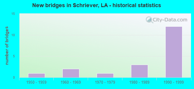
- New bridges - historical statistics
- 11950-1959
- 21960-1969
- 11970-1979
- 31980-1989
- 121990-1999
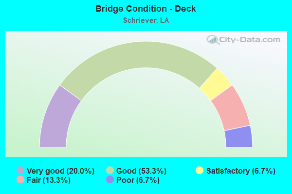
- Bridge Condition - Deck
- 20.0%Very good
- 53.3%Good
- 6.7%Satisfactory
- 13.3%Fair
- 6.7%Poor
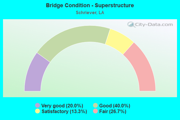
- Bridge Condition - Superstructure
- 20.0%Very good
- 40.0%Good
- 13.3%Satisfactory
- 26.7%Fair
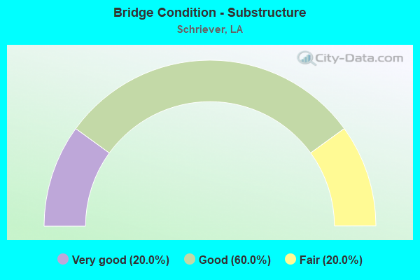
- Bridge Condition - Substructure
- 20.0%Very good
- 60.0%Good
- 20.0%Fair
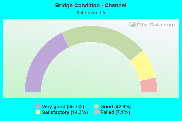
- Bridge Condition - Channel
- 35.7%Very good
- 42.9%Good
- 14.3%Satisfactory
- 7.1%Failed
Find on map >> Show street view
Structure Number: 22904130401571, Location: 2.5 MI NORTH OF US 90 (Lat: 29.737319, Lng: -90.919700), Route carried "on" structure: State highway 309, Year Built: 1995, Status: Open, Structure Length: 2.44m (8.01ft), Average Daily Traffic: 2,000 (year 2016), Truck Traffic: 12%, Average Future Daily Traffic: 3,000 (year 2036), Design Load: HS 20, Features Intersected: BUBBLING BAYOU
Minimum Vertical Clearance: 30+ m (98+ ft), Kilometerpoint: 2.515, Lanes on structure: 2, Owner: State Highway Agency, Approaching Roadway Width: 15.2m (49.9ft), Material/Design: Concrete, Design/Construction: Slab, Number Of Spans In Main Unit: 4, Length of Maximum Span: 6.1m (20.0ft), Curb-To-Curb Width: 12.0m (39.4ft), Out-to-Out Width: 13.1m (43.0ft)
Condition: Deck: Good, Superstructure: Good, Substructure: Good, Channel: Satisfactory, Operating Rating: 73.5 metric tons, Method Used To Determine Operating Rating: Load Factor (LF), Inventory Rating: 43.5 metric tons, Method Used To Determine Inventory Rating: Load Factor (LF), Structural Evaluation: Better than present minimum criteria, Deck Geometry: Equal to present minimum criteria, Waterway Adequacy: Equal to present minimum criteria, Approach Roadway Alignment: Equal to present desirable criteria, Designated Inspection Frequency: Every 24 months, Underwater Inspection Frequency: Every 60 months, Inspection Date: April 2020, Underwater Inspection Date: May 2019, Deck Structure Type: Concrete Cast-file-Place, Wearing Surface/Protective System: Wearing Surface: Monolithic Concrete
Find on map >> Show street view
Structure Number: 22904130403071, Location: 4.0 MI NORTH OF US 90 (Lat: 29.757761, Lng: -90.911600), Route carried "on" structure: State highway 309, Year Built: 1994, Status: Open, Structure Length: 3.05m (10.01ft), Average Daily Traffic: 2,000 (year 2016), Truck Traffic: 12%, Average Future Daily Traffic: 3,000 (year 2036), Design Load: HS 20, Features Intersected: PHILLIPS CANAL
Minimum Vertical Clearance: 30+ m (98+ ft), Kilometerpoint: 4.912, Lanes on structure: 2, Owner: State Highway Agency, Approaching Roadway Width: 15.2m (49.9ft), Material/Design: Concrete, Design/Construction: Slab, Number Of Spans In Main Unit: 5, Length of Maximum Span: 6.1m (20.0ft), Curb-To-Curb Width: 11.9m (39.0ft), Out-to-Out Width: 13.1m (43.0ft)
Condition: Deck: Good, Superstructure: Good, Substructure: Good, Channel: Failed, Operating Rating: 73.5 metric tons, Method Used To Determine Operating Rating: Load Factor (LF), Inventory Rating: 43.5 metric tons, Method Used To Determine Inventory Rating: Load Factor (LF), Structural Evaluation: Better than present minimum criteria, Deck Geometry: Equal to present minimum criteria, Waterway Adequacy: Equal to present desirable criteria, Approach Roadway Alignment: Better than present minimum criteria, Designated Inspection Frequency: Every 24 months, Inspection Date: April 2020, Deck Structure Type: Concrete Cast-file-Place, Wearing Surface/Protective System: Wearing Surface: Monolithic Concrete
Find on map >> Show street view
Structure Number: 22908292503811, Location: 2.3 MI WEST OF LA 3107 (Lat: 29.763931, Lng: -90.840300), Route carried "on" structure: State highway 3185, Year Built: 1969, Status: Open, Structure Length: 1.16m (3.81ft), Average Daily Traffic: 11,300 (year 2016), Truck Traffic: 11%, Average Future Daily Traffic: 16,800 (year 2036), Design Load: HS 20, Features Intersected: DRAIN CANAL
Minimum Vertical Clearance: 30+ m (98+ ft), Kilometerpoint: 6.173, Lanes on structure: 2, Owner: State Highway Agency, Approaching Roadway Width: 11.6m (38.1ft), Material/Design: Concrete, Design/Construction: Slab, Number Of Spans In Main Unit: 2, Length of Maximum Span: 5.8m (19.0ft), Curb-To-Curb Width: 8.6m (28.2ft), Out-to-Out Width: 9.3m (30.5ft)
Condition: Deck: Fair, Superstructure: Fair, Substructure: Good, Channel: Good, Operating Rating: 25.3 metric tons, Method Used To Determine Operating Rating: Load and Resistance Factor Rating (LRFR) rating reported by rating factor(RF) method using HL-93 loadings, Inventory Rating: 16.5 metric tons, Method Used To Determine Inventory Rating: Load and Resistance Factor Rating (LRFR) rating reported by rating factor(RF) method using HL-93 loadings, Structural Evaluation: Meets minimum limits, Deck Geometry: High priority of replacement, Waterway Adequacy: Equal to present desirable criteria, Approach Roadway Alignment: Equal to present desirable criteria, Length Of Structure Improvement: 1.80m (5.91ft), Designated Inspection Frequency: Every 24 months, Inspection Date: May 2020, Bridge Improvement Cost: $153,000, Roadway Improvement Cost: $15,000, Total Project Cost: $229,000 ( Estimate for 2016), Deck Structure Type: Concrete Precast Panels, Wearing Surface/Protective System: Wearing Surface: Bituminous
Find on map >> Show street view
Structure Number: 2550000000366, Location: 02550650410809 (Lat: 29.726939, Lng: -90.801400), Route carried "on" structure: Ramp State highway 24, Year Built: 1959, Status: Open, Structure Length: 1.74m (5.71ft), Average Daily Traffic: 280 (year 2015), Truck Traffic: 11%, Average Future Daily Traffic: 347 (year 2036), Design Load: H 15, Features Intersected: BAYOU TERREBONNE
Minimum Vertical Clearance: 30+ m (98+ ft), Kilometerpoint: 17.358, Lanes on structure: 2, Owner: State Highway Agency, Approaching Roadway Width: 7.9m (25.9ft), Material/Design: Concrete, Design/Construction: Slab, Number Of Spans In Main Unit: 3, Length of Maximum Span: 6.1m (20.0ft), Curb-To-Curb Width: 7.5m (24.6ft), Out-to-Out Width: 8.9m (29.2ft)
Condition: Deck: Poor, Superstructure: Fair, Substructure: Fair, Channel: Good, Operating Rating: 43.5 metric tons, Method Used To Determine Operating Rating: Load Factor (LF), Inventory Rating: 25.4 metric tons, Method Used To Determine Inventory Rating: Load Factor (LF), Structural Evaluation: Somewhat better than minimum adequacy, Deck Geometry: High priority of replacement, Waterway Adequacy: Equal to present minimum criteria, Approach Roadway Alignment: Equal to present desirable criteria, Length Of Structure Improvement: 2.44m (8.01ft), Designated Inspection Frequency: Every 24 months, Other Special Inspection Frequency: Every 12 months, Inspection Date: March 2020, Other Special Inspection Date: March 2021, Bridge Improvement Cost: $208,000, Total Project Cost: $312,000 ( Estimate for 2016), Deck Structure Type: Concrete Precast Panels, Wearing Surface/Protective System: Wearing Surface: Bituminous
Find on map >> Show street view
Structure Number: 25500650400609, Location: 0.01 M W OF LA 659 (Lat: 29.659469, Lng: -90.769200), Route carried "on" structure: Ramp State highway 24, Year Built: 1990, Status: Open, Structure Length: 0.82m (2.69ft), Average Daily Traffic: 258 (year 2015), Average Future Daily Traffic: 319 (year 2036), Design Load: HS 20, Features Intersected: BAYOU TERREBONNE
Minimum Vertical Clearance: 30+ m (98+ ft), Kilometerpoint: 9.135, Lanes on structure: 2, Owner: State Highway Agency, Approaching Roadway Width: 13.1m (43.0ft), Material/Design: Steel, Design/Construction: Culvert, Number Of Spans In Main Unit: 3, Length of Maximum Span: 2.4m (7.9ft), Curb-To-Curb Width: 13.1m (43.0ft), Out-to-Out Width: 30.5m (100.1ft)
Condition: Channel: Good, Culverts: Very good, Operating Rating: 97.2 metric tons, Method Used To Determine Operating Rating: Load and Resistance Factor Rating (LRFR) rating reported by rating factor(RF) method using HL-93 loadings, Inventory Rating: 74.5 metric tons, Method Used To Determine Inventory Rating: Load and Resistance Factor Rating (LRFR) rating reported by rating factor(RF) method using HL-93 loadings, Structural Evaluation: Equal to present desirable criteria, Deck Geometry: Superior to present desirable criteria, Waterway Adequacy: Equal to present minimum criteria, Approach Roadway Alignment: Equal to present desirable criteria, Designated Inspection Frequency: Every 24 months, Inspection Date: May 2020
Find on map >> Show street view
Structure Number: 25500650405359, Location: 0.01 M W OF LA 659 (Lat: 29.723550, Lng: -90.799911), Route carried "on" structure: Ramp State highway 24, Year Built: 1990, Status: Open, Structure Length: 0.82m (2.69ft), Average Daily Traffic: 420 (year 2016), Truck Traffic: 11%, Average Future Daily Traffic: 50 (year 2036), Design Load: HS 20, Features Intersected: BAYOU TERREBONNE
Minimum Vertical Clearance: 30+ m (98+ ft), Kilometerpoint: 10.561, Lanes on structure: 2, Owner: State Highway Agency, Approaching Roadway Width: 13.4m (44.0ft), Material/Design: Steel, Design/Construction: Culvert, Number Of Spans In Main Unit: 3, Length of Maximum Span: 2.4m (7.9ft), Curb-To-Curb Width: 13.4m (44.0ft), Out-to-Out Width: 30.5m (100.1ft)
Condition: Channel: Very good, Culverts: Very good, Operating Rating: 97.2 metric tons, Method Used To Determine Operating Rating: Load and Resistance Factor Rating (LRFR) rating reported by rating factor(RF) method using HL-93 loadings, Inventory Rating: 74.5 metric tons, Method Used To Determine Inventory Rating: Load and Resistance Factor Rating (LRFR) rating reported by rating factor(RF) method using HL-93 loadings, Structural Evaluation: Equal to present desirable criteria, Deck Geometry: Superior to present desirable criteria, Waterway Adequacy: Equal to present desirable criteria, Approach Roadway Alignment: Equal to present desirable criteria, Length Of Structure Improvement: 1.43m (4.69ft), Designated Inspection Frequency: Every 24 months, Inspection Date: May 2020, Bridge Improvement Cost: $134,000, Roadway Improvement Cost: $13,000, Total Project Cost: $201,000 ( Estimate for 2016)
Find on map >> Show street view
Structure Number: 25500650405859, Location: 0.01 M W OF LA 659 (Lat: 29.730131, Lng: -90.802061), Route carried "on" structure: Ramp State highway 24, Year Built: 1990, Status: Open, Structure Length: 0.82m (2.69ft), Average Daily Traffic: 280 (year 2015), Average Future Daily Traffic: 347 (year 2036), Design Load: HS 20, Features Intersected: BAYOU TERREBONNE
Minimum Vertical Clearance: 30+ m (98+ ft), Kilometerpoint: 17.704, Lanes on structure: 2, Owner: State Highway Agency, Approaching Roadway Width: 7.3m (24.0ft), Material/Design: Steel, Design/Construction: Culvert, Number Of Spans In Main Unit: 3, Length of Maximum Span: 2.4m (7.9ft), Curb-To-Curb Width: 7.3m (24.0ft), Out-to-Out Width: 30.5m (100.1ft)
Condition: Channel: Very good, Culverts: Very good, Operating Rating: 97.2 metric tons, Method Used To Determine Operating Rating: Load and Resistance Factor Rating (LRFR) rating reported by rating factor(RF) method using HL-93 loadings, Inventory Rating: 74.5 metric tons, Method Used To Determine Inventory Rating: Load and Resistance Factor Rating (LRFR) rating reported by rating factor(RF) method using HL-93 loadings, Structural Evaluation: Equal to present desirable criteria, Deck Geometry: High priority of replacement, Waterway Adequacy: Equal to present desirable criteria, Approach Roadway Alignment: Equal to present desirable criteria, Designated Inspection Frequency: Every 24 months, Inspection Date: May 2020
Find on map >> Show street view
Structure Number: 25500650406159, Location: 0.01 M W OF LA 659 (Lat: 29.735161, Lng: -90.803181), Route carried "on" structure: Ramp State highway 24, Year Built: 1990, Status: Open, Structure Length: 0.82m (2.69ft), Average Daily Traffic: 280 (year 2015), Average Future Daily Traffic: 347 (year 2036), Design Load: HS 20, Features Intersected: BAYOU TERREBONNE
Minimum Vertical Clearance: 30+ m (98+ ft), Kilometerpoint: 18.277, Lanes on structure: 2, Owner: State Highway Agency, Approaching Roadway Width: 13.7m (44.9ft), Material/Design: Steel, Design/Construction: Culvert, Number Of Spans In Main Unit: 3, Length of Maximum Span: 2.4m (7.9ft), Curb-To-Curb Width: 13.7m (44.9ft), Out-to-Out Width: 30.5m (100.1ft)
Condition: Channel: Very good, Culverts: Very good, Operating Rating: 97.2 metric tons, Method Used To Determine Operating Rating: Load and Resistance Factor Rating (LRFR) rating reported by rating factor(RF) method using HL-93 loadings, Inventory Rating: 74.5 metric tons, Method Used To Determine Inventory Rating: Load and Resistance Factor Rating (LRFR) rating reported by rating factor(RF) method using HL-93 loadings, Structural Evaluation: Equal to present desirable criteria, Deck Geometry: Superior to present desirable criteria, Waterway Adequacy: Equal to present desirable criteria, Approach Roadway Alignment: Equal to present desirable criteria, Designated Inspection Frequency: Every 24 months, Inspection Date: May 2020
Find on map >> Show street view
Structure Number: 25500659121701, Location: LA0024 (Lat: 29.745131, Lng: -90.811300), Route carried "on" structure: State highway 24, Year Built: 1970, Status: Open, Structure Length: 66.20m (217.19ft), Average Daily Traffic: 25,900 (year 2016), Truck Traffic: 10%, Average Future Daily Traffic: 32,116 (year 2036), Design Load: HS 20, Features Intersected: SPRR & LA 20
Minimum Vertical Clearance: 30+ m (98+ ft), Kilometerpoint: 19.690, Lanes on structure: 4, Lanes under structure: 4, Base Highway Network: Yes (Inventory Route: 65-04-1, Subroute: 10), Owner: State Highway Agency, Approaching Roadway Width: 23.2m (76.1ft), Skew: 30 degrees, Material/Design: Prestressed concrete, Design/Construction: Stringer/Multi-beam, Number Of Spans In Main Unit: 31, Length of Maximum Span: 21.3m (69.9ft), Curb-To-Curb Width: 17.1m (56.1ft), Out-to-Out Width: 19.9m (65.3ft)
Condition: Deck: Satisfactory, Superstructure: Good, Substructure: Fair, Operating Rating: 79.8 metric tons, Method Used To Determine Operating Rating: Load Factor (LF), Inventory Rating: 34.5 metric tons, Method Used To Determine Inventory Rating: Load Factor (LF), Structural Evaluation: Somewhat better than minimum adequacy, Deck Geometry: Somewhat better than minimum adequacy, Underclear: Equal to present minimum criteria, Approach Roadway Alignment: Equal to present desirable criteria, Designated Inspection Frequency: Every 24 months, Inspection Date: October 2021, Deck Structure Type: Concrete Cast-file-Place
Find on map >> Show street view
Structure Number: 25502440107231, Location: 7.2 MI EAST JCT US 90 (Lat: 29.715119, Lng: -90.888500), Route carried "on" structure: State highway 20, Year Built: 1984, Status: Open, Structure Length: 3.66m (12.01ft), Average Daily Traffic: 4,800 (year 2016), Truck Traffic: 20%, Average Future Daily Traffic: 5,952 (year 2036), Design Load: HS 20, Features Intersected: DRAINAGE CANAL
Minimum Vertical Clearance: 30+ m (98+ ft), Kilometerpoint: 11.562, Lanes on structure: 2, Base Highway Network: Yes (Inventory Route: 244-01-1, Subroute: 10), Owner: State Highway Agency, Approaching Roadway Width: 12.2m (40.0ft), Material/Design: Concrete, Design/Construction: Slab, Number Of Spans In Main Unit: 6, Length of Maximum Span: 6.1m (20.0ft), Curb-To-Curb Width: 12.2m (40.0ft), Out-to-Out Width: 13.1m (43.0ft)
Condition: Deck: Good, Superstructure: Good, Substructure: Good, Channel: Good, Operating Rating: 68.0 metric tons, Method Used To Determine Operating Rating: Load Factor (LF), Inventory Rating: 40.8 metric tons, Method Used To Determine Inventory Rating: Load Factor (LF), Structural Evaluation: Better than present minimum criteria, Deck Geometry: Equal to present minimum criteria, Waterway Adequacy: Better than present minimum criteria, Approach Roadway Alignment: Equal to present desirable criteria, Designated Inspection Frequency: Every 24 months, Underwater Inspection Frequency: Every 60 months, Inspection Date: January 2020, Underwater Inspection Date: May 2019, Deck Structure Type: Concrete Precast Panels
Find on map >> Show street view
Structure Number: 25502440109431, Location: 9.4 MI EAST JCT US 90 (Lat: 29.729089, Lng: -90.855700), Route carried "on" structure: State highway 20, Year Built: 1984, Status: Open, Structure Length: 1.83m (6.00ft), Average Daily Traffic: 4,800 (year 2016), Truck Traffic: 20%, Average Future Daily Traffic: 5,952 (year 2036), Design Load: HS 20, Features Intersected: DRAINAGE CANAL
Minimum Vertical Clearance: 30+ m (98+ ft), Kilometerpoint: 2.649, Lanes on structure: 2, Base Highway Network: Yes (Inventory Route: 244-03-1, Subroute: 10), Owner: State Highway Agency, Approaching Roadway Width: 12.2m (40.0ft), Material/Design: Concrete, Design/Construction: Slab, Number Of Spans In Main Unit: 3, Length of Maximum Span: 6.1m (20.0ft), Curb-To-Curb Width: 12.2m (40.0ft), Out-to-Out Width: 13.1m (43.0ft)
Condition: Deck: Good, Superstructure: Good, Substructure: Good, Channel: Satisfactory, Operating Rating: 45.4 metric tons, Method Used To Determine Operating Rating: Load and Resistance Factor Rating (LRFR) rating reported by rating factor(RF) method using HL-93 loadings, Inventory Rating: 35.0 metric tons, Method Used To Determine Inventory Rating: Load and Resistance Factor Rating (LRFR) rating reported by rating factor(RF) method using HL-93 loadings, Structural Evaluation: Better than present minimum criteria, Deck Geometry: Equal to present minimum criteria, Waterway Adequacy: Better than present minimum criteria, Approach Roadway Alignment: Equal to present desirable criteria, Designated Inspection Frequency: Every 24 months, Underwater Inspection Frequency: Every 60 months, Inspection Date: January 2020, Underwater Inspection Date: May 2019, Deck Structure Type: Concrete Precast Panels
Find on map >> Show street view
Structure Number: 25504240708361, Location: .5 MI EAST OF LA 311 (Lat: 29.707139, Lng: -90.914400), Route carried "on" structure: US 90, Year Built: 1995, Status: Open, Structure Length: 900.50m (2954.40ft), Average Daily Traffic: 11,400 (year 2016), Truck Traffic: 18%, Average Future Daily Traffic: 16,591 (year 2036), Design Load: HS 20, Features Intersected: DRAIN CANALS,LA.20,RR
Minimum Vertical Clearance: 30+ m (98+ ft), Kilometerpoint: 13.992, Lanes on structure: 2, Lanes under structure: 5, Base Highway Network: Yes (Inventory Route: 424-07-1, Subroute: 10), Owner: State Highway Agency, Approaching Roadway Width: 15.2m (49.9ft), Skew: 30 degrees, Material/Design: Prestressed concrete, Design/Construction: Stringer/Multi-beam, Number Of Spans In Main Unit: 430, Length of Maximum Span: 29.0m (95.1ft), Curb-To-Curb Width: 12.2m (40.0ft), Out-to-Out Width: 13.1m (43.0ft)
Condition: Deck: Good, Superstructure: Fair, Substructure: Good, Channel: Very good, Operating Rating: 54.4 metric tons, Method Used To Determine Operating Rating: Load Factor (LF), Inventory Rating: 32.7 metric tons, Method Used To Determine Inventory Rating: Load Factor (LF), Structural Evaluation: Somewhat better than minimum adequacy, Deck Geometry: Better than present minimum criteria, Underclear: Somewhat better than minimum adequacy, Approach Roadway Alignment: Equal to present desirable criteria, Designated Inspection Frequency: Every 24 months, Underwater Inspection Frequency: Every 60 months, Inspection Date: October 2021, Underwater Inspection Date: October 2020, Deck Structure Type: Concrete Cast-file-Place, Wearing Surface/Protective System: Wearing Surface: Monolithic Concrete
Find on map >> Show street view
Structure Number: 25504240708362, Location: .5 MI EAST OF LA 311 (Lat: 29.683419, Lng: -90.827500), Route carried "on" structure: US 90, Year Built: 1995, Status: Open, Structure Length: 900.50m (2954.40ft), Average Daily Traffic: 11,400 (year 2016), Truck Traffic: 18%, Average Future Daily Traffic: 16,591 (year 2036), Design Load: HS 20, Features Intersected: DRAINAGE CANALS,LA.20,RR
Minimum Vertical Clearance: 30+ m (98+ ft), Kilometerpoint: 7.129, Lanes on structure: 2, Lanes under structure: 5, Base Highway Network: Yes (Inventory Route: 424-07-2, Subroute: 10), Owner: State Highway Agency, Approaching Roadway Width: 15.2m (49.9ft), Skew: 30 degrees, Material/Design: Prestressed concrete, Design/Construction: Stringer/Multi-beam, Number Of Spans In Main Unit: 430, Length of Maximum Span: 29.0m (95.1ft), Curb-To-Curb Width: 12.2m (40.0ft), Out-to-Out Width: 13.1m (43.0ft)
Condition: Deck: Good, Superstructure: Satisfactory, Substructure: Good, Operating Rating: 54.4 metric tons, Method Used To Determine Operating Rating: Load Factor (LF), Inventory Rating: 32.7 metric tons, Method Used To Determine Inventory Rating: Load Factor (LF), Structural Evaluation: Equal to present minimum criteria, Deck Geometry: Better than present minimum criteria, Underclear: Somewhat better than minimum adequacy, Approach Roadway Alignment: Equal to present desirable criteria, Designated Inspection Frequency: Every 24 months, Inspection Date: October 2021, Deck Structure Type: Concrete Cast-file-Place, Wearing Surface/Protective System: Wearing Surface: Monolithic Concrete
Find on map >> Show street view
Structure Number: 25504240709018, Location: .10 MI. FROM LA.20 (Lat: 29.706181, Lng: -90.899000), Route carried "on" structure: Ramp US 90, Year Built: 1995, Status: Open, Structure Length: 19.05m (62.50ft), Average Daily Traffic: 2,280 (year 2016), Truck Traffic: 18%, Average Future Daily Traffic: 2,765 (year 2036), Design Load: HS 20, Features Intersected: SWAMP
Minimum Vertical Clearance: 30+ m (98+ ft), Kilometerpoint: 0.192, Lanes on structure: 1, Owner: State Highway Agency, Approaching Roadway Width: 7.6m (24.9ft), Material/Design: Prestressed concrete, Design/Construction: Stringer/Multi-beam, Number Of Spans In Main Unit: 9, Length of Maximum Span: 21.3m (69.9ft), Curb-To-Curb Width: 7.6m (24.9ft), Out-to-Out Width: 8.5m (27.9ft)
Condition: Deck: Very good, Superstructure: Very good, Substructure: Very good, Operating Rating: 66.2 metric tons, Method Used To Determine Operating Rating: Load Factor (LF), Inventory Rating: 39.9 metric tons, Method Used To Determine Inventory Rating: Load Factor (LF), Structural Evaluation: Equal to present desirable criteria, Deck Geometry: Better than present minimum criteria, Approach Roadway Alignment: Better than present minimum criteria, Designated Inspection Frequency: Every 24 months, Inspection Date: April 2021, Deck Structure Type: Concrete Cast-file-Place, Wearing Surface/Protective System: Wearing Surface: Monolithic Concrete
Find on map >> Show street view
Structure Number: 25504240709117, Location: .1 MI.FROM LA.20 (Lat: 29.707039, Lng: -90.902500), Route carried "on" structure: Ramp US 90, Year Built: 1995, Status: Open, Structure Length: 19.32m (63.39ft), Average Daily Traffic: 2,280 (year 2016), Truck Traffic: 18%, Average Future Daily Traffic: 2,765 (year 2036), Design Load: HS 20, Features Intersected: SWAMP
Minimum Vertical Clearance: 30+ m (98+ ft), Kilometerpoint: 0.153, Lanes on structure: 1, Owner: State Highway Agency, Approaching Roadway Width: 10.7m (35.1ft), Material/Design: Prestressed concrete, Design/Construction: Stringer/Multi-beam, Number Of Spans In Main Unit: 12, Length of Maximum Span: 21.3m (69.9ft), Curb-To-Curb Width: 9.4m (30.8ft), Out-to-Out Width: 10.4m (34.1ft)
Condition: Deck: Very good, Superstructure: Satisfactory, Substructure: Good, Operating Rating: 46.7 metric tons, Method Used To Determine Operating Rating: Load and Resistance Factor Rating (LRFR) rating reported by rating factor(RF) method using HL-93 loadings, Inventory Rating: 29.8 metric tons, Method Used To Determine Inventory Rating: Load and Resistance Factor Rating (LRFR) rating reported by rating factor(RF) method using HL-93 loadings, Structural Evaluation: Equal to present minimum criteria, Deck Geometry: Superior to present desirable criteria, Approach Roadway Alignment: Better than present minimum criteria, Designated Inspection Frequency: Every 24 months, Inspection Date: May 2021, Deck Structure Type: Concrete Cast-file-Place, Wearing Surface/Protective System: Wearing Surface: Monolithic Concrete
Find on map >> Show street view
Structure Number: 25504240709366, Location: .1 MI. FROM LA. 20 (Lat: 29.708461, Lng: -90.901300), Route carried "on" structure: Ramp US 90, Year Built: 1995, Status: Open, Structure Length: 23.47m (77.00ft), Average Daily Traffic: 2,280 (year 2016), Truck Traffic: 18%, Average Future Daily Traffic: 2,765 (year 2036), Design Load: HS 20, Features Intersected: SWAMP
Minimum Vertical Clearance: 30+ m (98+ ft), Kilometerpoint: 0.164, Lanes on structure: 1, Owner: State Highway Agency, Approaching Roadway Width: 9.1m (29.9ft), Material/Design: Prestressed concrete, Design/Construction: Stringer/Multi-beam, Number Of Spans In Main Unit: 15, Length of Maximum Span: 21.3m (69.9ft), Curb-To-Curb Width: 8.8m (28.9ft), Out-to-Out Width: 9.8m (32.2ft)
Condition: Deck: Good, Superstructure: Very good, Substructure: Very good, Channel: Very good, Operating Rating: 59.0 metric tons, Method Used To Determine Operating Rating: Load Factor (LF), Inventory Rating: 35.4 metric tons, Method Used To Determine Inventory Rating: Load Factor (LF), Structural Evaluation: Equal to present desirable criteria, Deck Geometry: Superior to present desirable criteria, Approach Roadway Alignment: Equal to present desirable criteria, Designated Inspection Frequency: Every 24 months, Inspection Date: October 2021, Deck Structure Type: Concrete Cast-file-Place, Wearing Surface/Protective System: Wearing Surface: Monolithic Concrete
Find on map >> Show street view
Structure Number: 25504240709415, Location: .10 MI. FROM LA.20 (Lat: 29.705389, Lng: -90.899500), Route carried "on" structure: Ramp US 90, Year Built: 1995, Status: Open, Structure Length: 14.78m (48.49ft), Average Daily Traffic: 2,280 (year 2016), Truck Traffic: 18%, Average Future Daily Traffic: 2,765 (year 2036), Design Load: HS 20, Features Intersected: SWAMP
Minimum Vertical Clearance: 30+ m (98+ ft), Kilometerpoint: 0.843, Lanes on structure: 1, Owner: State Highway Agency, Approaching Roadway Width: 7.6m (24.9ft), Material/Design: Prestressed concrete, Design/Construction: Stringer/Multi-beam, Number Of Spans In Main Unit: 7, Length of Maximum Span: 21.3m (69.9ft), Curb-To-Curb Width: 7.6m (24.9ft), Out-to-Out Width: 8.5m (27.9ft)
Condition: Deck: Very good, Superstructure: Very good, Substructure: Very good, Operating Rating: 66.2 metric tons, Method Used To Determine Operating Rating: Load Factor (LF), Inventory Rating: 39.9 metric tons, Method Used To Determine Inventory Rating: Load Factor (LF), Structural Evaluation: Equal to present desirable criteria, Deck Geometry: Better than present minimum criteria, Approach Roadway Alignment: Equal to present desirable criteria, Designated Inspection Frequency: Every 24 months, Inspection Date: August 2020, Deck Structure Type: Concrete Cast-file-Place, Wearing Surface/Protective System: Wearing Surface: Monolithic Concrete
Find on map >> Show street view
Structure Number: 25529410905341, Location: 0220 LOG MI FROM IN (Lat: 29.683331, Lng: -90.890000), Route carried "on" structure: County highway , Year Built: 1968, Status: Posted for load, Structure Length: 3.47m (11.38ft), Average Daily Traffic: 1,000 (year 1978), Average Future Daily Traffic: 1,240 (year 2036), Design Load: HS 20, Features Intersected: TERR LAF DRAINAGE CANAL, Facility Carried by Structure: BULL RUN RD
Minimum Vertical Clearance: 30+ m (98+ ft), Kilometerpoint: 0.000, Lanes on structure: 2, Owner: County Highway Agency, Approaching Roadway Width: 9.1m (29.9ft), Material/Design: Concrete, Design/Construction: Slab, Number Of Spans In Main Unit: 6, Length of Maximum Span: 5.8m (19.0ft), Curb-To-Curb Width: 7.5m (24.6ft), Out-to-Out Width: 8.0m (26.2ft)
Condition: Deck: Fair, Superstructure: Fair, Substructure: Fair, Channel: Good, Operating Rating: 21.4 metric tons, Method Used To Determine Operating Rating: Load and Resistance Factor Rating (LRFR) rating reported by rating factor(RF) method using HL-93 loadings, Inventory Rating: 16.5 metric tons, Method Used To Determine Inventory Rating: Load and Resistance Factor Rating (LRFR) rating reported by rating factor(RF) method using HL-93 loadings, Structural Evaluation: Meets minimum limits, Deck Geometry: Meets minimum limits, Waterway Adequacy: Better than present minimum criteria, Approach Roadway Alignment: Equal to present minimum criteria, Bridge Posting: Required (Relationship of Operating Rating to Maximum Legal Load: 0.1 - 9.9% below), Designated Inspection Frequency: Every 24 months, Underwater Inspection Frequency: Every 60 months, Inspection Date: April 2021, Underwater Inspection Date: May 2019, Deck Structure Type: Concrete Precast Panels, Wearing Surface/Protective System: Wearing Surface: Bituminous
Find on map >> Show street view
Structure Number: 25529436904781, Location: 03.15 MI FROM LA 24 (Lat: 29.728619, Lng: -90.796311), Route carried "on" structure: County highway , Year Built: 1986, Status: Open, Structure Length: 2.32m (7.61ft), Average Daily Traffic: 136 (year 1984), Average Future Daily Traffic: 168 (year 2036), Design Load: HS 20, Features Intersected: DEVIL SWAMP CANAL, Facility Carried by Structure: Waterplant Rd
Minimum Vertical Clearance: 30+ m (98+ ft), Kilometerpoint: 0.000, Lanes on structure: 2, Owner: County Highway Agency, Approaching Roadway Width: 6.7m (22.0ft), Skew: 7 degrees, Material/Design: Concrete, Design/Construction: Slab, Number Of Spans In Main Unit: 4, Length of Maximum Span: 5.8m (19.0ft), Curb-To-Curb Width: 7.3m (24.0ft), Out-to-Out Width: 8.2m (26.9ft)
Condition: Deck: Good, Superstructure: Good, Substructure: Good, Channel: Good, Operating Rating: 27.9 metric tons, Method Used To Determine Operating Rating: Load and Resistance Factor Rating (LRFR) rating reported by rating factor(RF) method using HL-93 loadings, Inventory Rating: 21.4 metric tons, Method Used To Determine Inventory Rating: Load and Resistance Factor Rating (LRFR) rating reported by rating factor(RF) method using HL-93 loadings, Structural Evaluation: Equal to present minimum criteria, Deck Geometry: Somewhat better than minimum adequacy, Waterway Adequacy: Better than present minimum criteria, Approach Roadway Alignment: Equal to present desirable criteria, Designated Inspection Frequency: Every 24 months, Inspection Date: May 2021, Deck Structure Type: Concrete Precast Panels, Wearing Surface/Protective System: Wearing Surface: Monolithic Concrete
Find on map >> Show street view
Structure Number: 25500659121701, Location: .1 miles N of LA 24 (Lat: 29.745431, Lng: -90.811389), Route carried "under" structure: State highway 20, Structure Length: 0. m, Average Daily Traffic: 2,400 (year 2015), Features Intersected: LA 20 WB under LA 20 Sch
Minimum Vertical Clearance: 4.91m (16.11ft), Kilometerpoint: 0.594, Lanes on structure: 4, Lanes under structure: 2, Length of Maximum Span: 0.0m
Find on map >> Show street view
Structure Number: 25500659121701, Location: .1 miles N of LA 24 (Lat: 29.745319, Lng: -90.811550), Route carried "under" structure: State highway 20, Structure Length: 0. m, Average Daily Traffic: 2,400 (year 2015), Features Intersected: LA 20 EB under LA 20 Sch
Minimum Vertical Clearance: 4.85m (15.91ft), Kilometerpoint: 7.318, Lanes on structure: 4, Lanes under structure: 2, Length of Maximum Span: 0.0m
Find on map >> Show street view
Structure Number: 25504240708361, Location: .3 mile E of LA 309 (Lat: 29.708031, Lng: -90.904731), Route carried "under" structure: State highway 20, Structure Length: 0. m, Average Daily Traffic: 2,400 (year 2014), Features Intersected: LA 20 EB under US 90 EB
Minimum Vertical Clearance: 8.08m (26.51ft), Kilometerpoint: 9.799, Lanes on structure: 2, Lanes under structure: 2, Length of Maximum Span: 0.0m
Find on map >> Show street view
Structure Number: 25504240708361, Location: .1 mile N of LA 20 (Lat: 29.708069, Lng: -90.911369), Route carried "under" structure: State highway 309, Structure Length: 0. m, Average Daily Traffic: 1,650 (year 2016), Features Intersected: LA 309 under US 90 EB
Minimum Vertical Clearance: 5.21m (17.09ft), Kilometerpoint: 0.246, Lanes on structure: 2, Lanes under structure: 2, Length of Maximum Span: 0.0m
Find on map >> Show street view
Structure Number: 25504240708361, Location: .3 miles E of LA 309 (Lat: 29.708211, Lng: -90.904839), Route carried "under" structure: State highway 20, Structure Length: 0. m, Average Daily Traffic: 2,400 (year 2014), Features Intersected: LA 20 WB under US 90 EB
Minimum Vertical Clearance: 8.23m (27.00ft), Kilometerpoint: 2.169, Lanes on structure: 2, Lanes under structure: 2, Length of Maximum Span: 0.0m
Find on map >> Show street view
Structure Number: 25504240708362, Location: .3 miles E of LA 309 (Lat: 29.708350, Lng: -90.904419), Route carried "under" structure: State highway 20, Structure Length: 0. m, Average Daily Traffic: 2,400 (year 2014), Features Intersected: LA 20 WB under US 90 WB
Minimum Vertical Clearance: 8.20m (26.90ft), Kilometerpoint: 2.126, Lanes on structure: 2, Lanes under structure: 2, Length of Maximum Span: 0.0m
Find on map >> Show street view
Structure Number: 25504240708362, Location: .3 miles E of LA 309 (Lat: 29.708161, Lng: -90.904389), Route carried "under" structure: State highway 20, Structure Length: 0. m, Average Daily Traffic: 2,400 (year 2014), Features Intersected: LA 20 EB under US 90 WB
Minimum Vertical Clearance: 7.99m (26.21ft), Kilometerpoint: 9.836, Lanes on structure: 2, Lanes under structure: 2, Length of Maximum Span: 0.0m
Find on map >> Show street view
Structure Number: 25504240708362, Location: .1 mile N of LA 20 (Lat: 29.708311, Lng: -90.911481), Route carried "under" structure: State highway 309, Structure Length: 0. m, Average Daily Traffic: 1,650 (year 2016), Features Intersected: LA 309 under US 90 WB
Minimum Vertical Clearance: 5.30m (17.39ft), Kilometerpoint: 0.275, Lanes on structure: 2, Lanes under structure: 2, Length of Maximum Span: 0.0m