Bridge Statistics for Scotchtown, New York (NY)
Condition, Traffic, Stress, Structural Evaluation, Project Costs
- National Bridge Inventory (NBI) Statistics
- 28Number of bridges
- 299ft / 90.8mTotal length
- $87,562,000Total costs
- 349,416Total average daily traffic
- 32,545Total average daily truck traffic
- National Bridge Inventory (NBI) Registered Bridges for Scotchtown
- No street view available for this location
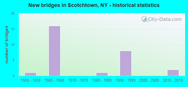
- New bridges - historical statistics
- 11950-1959
- 161960-1969
- 11980-1989
- 81990-1999
- 22010-2019
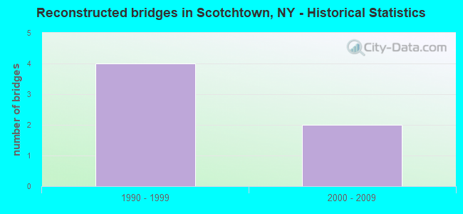
- Reconstructed bridges - Historical Statistics
- 41990-1999
- 22000-2009
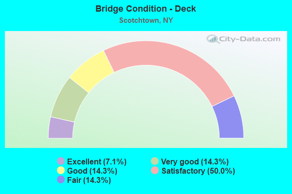
- Bridge Condition - Deck
- 7.1%Excellent
- 14.3%Very good
- 14.3%Good
- 50.0%Satisfactory
- 14.3%Fair
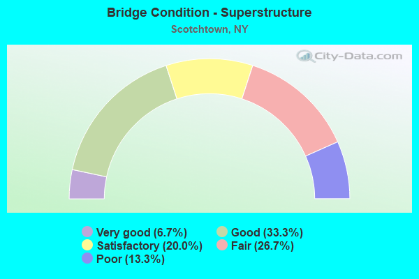
- Bridge Condition - Superstructure
- 6.7%Very good
- 33.3%Good
- 20.0%Satisfactory
- 26.7%Fair
- 13.3%Poor
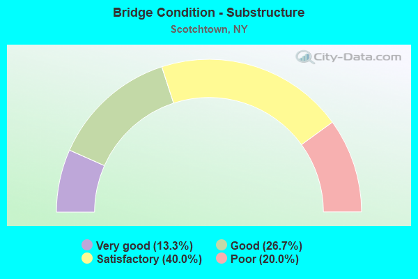
- Bridge Condition - Substructure
- 13.3%Very good
- 26.7%Good
- 40.0%Satisfactory
- 20.0%Poor
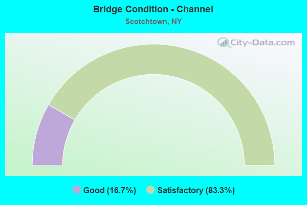
- Bridge Condition - Channel
- 16.7%Good
- 83.3%Satisfactory
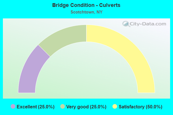
- Bridge Condition - Culverts
- 25.0%Excellent
- 25.0%Very good
- 50.0%Satisfactory
Find on map >> Show street view
Structure Number: 101393, Location: 3.5 MI S JCT SH17 & SH17K (Lat: 41.503031, Lng: -74.408125), Route carried "on" structure: City street 17M, Year Built: 1998, Status: Open, Structure Length: 7.41m (24.31ft), Average Daily Traffic: 765 (year 2020), Truck Traffic: 4%, Average Future Daily Traffic: 1,071 (year 2040), Design Load: HS 25 or greater, Features Intersected: 17 17 83101041, RTE 17
Minimum Vertical Clearance: 30+ m (98+ ft), Kilometerpoint: 0.306, Lanes on structure: 2, Lanes under structure: 4, Owner: State Highway Agency, Approaching Roadway Width: 9.8m (32.2ft), Skew: 3 degrees, Material/Design: Prestressed concrete continuous, Design/Construction: Segmental Box Girder, Number Of Spans In Main Unit: 2, Length of Maximum Span: 36.2m (118.8ft), Curb-To-Curb Width: 9.8m (32.2ft), Out-to-Out Width: 11.3m (37.1ft)
Condition: Deck: Satisfactory, Superstructure: Fair, Substructure: Very good, Operating Rating: 73.5 metric tons, Method Used To Determine Operating Rating: Load Factor (LF), Inventory Rating: 43.5 metric tons, Method Used To Determine Inventory Rating: Load Factor (LF), Structural Evaluation: Somewhat better than minimum adequacy, Deck Geometry: Equal to present minimum criteria, Underclear: Somewhat better than minimum adequacy, Approach Roadway Alignment: Equal to present desirable criteria, Length Of Structure Improvement: 7.40m (24.28ft), Designated Inspection Frequency: Every 24 months, Critical Feature Inspection Frequency: Every 24 months, Inspection Date: November 2020, Critical Feature Inspection Date: November 2020, Bridge Improvement Cost: $9,920,000, Roadway Improvement Cost: $5,809,000, Total Project Cost: $15,730,000 ( Estimate for 2021), Deck Structure Type: Other, Wearing Surface/Protective System: Wearing Surface: Integral Concrete
Find on map >> Show street view
Structure Number: 101394, Location: JCT RTS 17 & 302 (Lat: 41.494833, Lng: -74.401475), Route carried "on" structure: State highway 302, Year Built: 1998, Status: Open, Structure Length: 6.89m (22.60ft), Average Daily Traffic: 8,121 (year 2018), Truck Traffic: 7%, Average Future Daily Traffic: 10,048 (year 2040), Design Load: HS 25 or greater, Features Intersected: 17 17 83101047 WB, RTE
Minimum Vertical Clearance: 30+ m (98+ ft), Kilometerpoint: 1.030, Lanes on structure: 2, Lanes under structure: 6, Base Highway Network: Yes, Owner: State Highway Agency, Approaching Roadway Width: 9.1m (29.9ft), Skew: 22 degrees, Material/Design: Steel continuous, Design/Construction: Stringer/Multi-beam, Number Of Spans In Main Unit: 2, Length of Maximum Span: 34.1m (111.9ft), Curb-To-Curb Width: 12.3m (40.4ft), Out-to-Out Width: 13.2m (43.3ft)
Condition: Deck: Satisfactory, Superstructure: Good, Substructure: Satisfactory, Operating Rating: 73.5 metric tons, Method Used To Determine Operating Rating: Load Factor (LF), Inventory Rating: 43.5 metric tons, Method Used To Determine Inventory Rating: Load Factor (LF), Structural Evaluation: Equal to present minimum criteria, Deck Geometry: Somewhat better than minimum adequacy, Underclear: Meets minimum limits, Approach Roadway Alignment: Better than present minimum criteria, Length Of Structure Improvement: 6.88m (22.57ft), Designated Inspection Frequency: Every 24 months, Inspection Date: April 2020, Bridge Improvement Cost: $3,712,000, Roadway Improvement Cost: $2,174,000, Total Project Cost: $5,886,000 ( Estimate for 2021), Deck Structure Type: Concrete Cast-file-Place, Wearing Surface/Protective System: Wearing Surface: Integral Concrete, Deck Protection: Epoxy Coated Reinforcing
Find on map >> Show street view
Structure Number: 1013959, Location: JCT RTS 17+211 (Lat: 41.459847, Lng: -74.377197), Route carried "on" structure: State highway 17, Year Built: 1969, Year Reconstructed: 2009, Status: Open, Structure Length: 3.87m (12.70ft), Average Daily Traffic: 55,134 (year 2007), Truck Traffic: 11%, Average Future Daily Traffic: 77,777 (year 2040), Design Load: HS 25 or greater, Features Intersected: 211 211 8301 3015 EB, RT
Minimum Vertical Clearance: 30+ m (98+ ft), Kilometerpoint: 11.858, Lanes on structure: 6, Lanes under structure: 6, Base Highway Network: Yes, Owner: State Highway Agency, Approaching Roadway Width: 34.1m (111.9ft), Skew: 32 degrees, Material/Design: Steel, Design/Construction: Stringer/Multi-beam, Number Of Spans In Main Unit: 1, Length of Maximum Span: 36.8m (120.7ft), Curb-To-Curb Width: 36.6m (120.1ft), Out-to-Out Width: 38.7m (127.0ft)
Condition: Deck: Very good, Superstructure: Good, Substructure: Good, Operating Rating: 69.9 metric tons, Method Used To Determine Operating Rating: Load Factor (LF), Inventory Rating: 41.7 metric tons, Method Used To Determine Inventory Rating: Load Factor (LF), Structural Evaluation: Better than present minimum criteria, Deck Geometry: Superior to present desirable criteria, Underclear: High priority of corrective action, Approach Roadway Alignment: Equal to present desirable criteria, Length Of Structure Improvement: 3.87m (12.70ft), Designated Inspection Frequency: Every 24 months, Inspection Date: September 2021, Bridge Improvement Cost: $9,311,000, Roadway Improvement Cost: $5,452,000, Total Project Cost: $14,763,000 ( Estimate for 2021), Deck Structure Type: Concrete Cast-file-Place, Wearing Surface/Protective System: Wearing Surface: Integral Concrete, Deck Protection: Other Coated Reinforcing
Find on map >> Show street view
Structure Number: 104097, Location: 2.5 MI E JCT SH211 & SH17 (Lat: 41.469794, Lng: -74.332692), Route carried "on" structure: State highway 211, Year Built: 2017, Status: Open, Structure Length: 1.04m (3.41ft), Average Daily Traffic: 5,915 (year 2018), Truck Traffic: 8%, Average Future Daily Traffic: 7,185 (year 2040), Design Load: HL 93, Features Intersected: UNNAMED STREAM
Minimum Vertical Clearance: 30+ m (98+ ft), Kilometerpoint: 26.178, Lanes on structure: 2, Base Highway Network: Yes, Owner: State Highway Agency, Approaching Roadway Width: 9.8m (32.2ft), Skew: 3 degrees, Material/Design: Concrete, Design/Construction: Culvert, Number Of Spans In Main Unit: 1, Length of Maximum Span: 9.8m (32.2ft)
Condition: Channel: Satisfactory, Culverts: Excellent, Structural Evaluation: Superior to present desirable criteria, Waterway Adequacy: Superior to present desirable criteria, Approach Roadway Alignment: Meets minimum limits, Length Of Structure Improvement: 1.03m (3.38ft), Designated Inspection Frequency: Every 24 months, Inspection Date: August 2021, Bridge Improvement Cost: $285,000, Roadway Improvement Cost: $167,000, Total Project Cost: $452,000 ( Estimate for 2021)
Find on map >> Show street view
Structure Number: 1052561, Location: 0.7 MI E JCT RTS 17 & I84 (Lat: 41.453058, Lng: -74.358278), Route carried "on" structure: Other road , Year Built: 1998, Status: Open, Structure Length: 9.20m (30.18ft), Average Daily Traffic: 3,262 (year 2017), Truck Traffic: 5%, Average Future Daily Traffic: 4,036 (year 2040), Design Load: HS 25 or greater, Features Intersected: 84I 84I83011198 EB, RTE, Facility Carried by Structure: BALLARD ROAD
Minimum Vertical Clearance: 30+ m (98+ ft), Kilometerpoint: 0.290, Lanes on structure: 2, Lanes under structure: 4, Owner: State Highway Agency, Approaching Roadway Width: 10.1m (33.1ft), Material/Design: Steel continuous, Design/Construction: Stringer/Multi-beam, Number Of Spans In Main Unit: 2, Length of Maximum Span: 45.7m (149.9ft), Curb-To-Curb Width: 10.0m (32.8ft), Out-to-Out Width: 11.1m (36.4ft)
Condition: Deck: Good, Superstructure: Very good, Substructure: Satisfactory, Inventory Rating: 40.8 metric tons, Method Used To Determine Inventory Rating: Field evaluation and documented engineering judgment, Structural Evaluation: Equal to present minimum criteria, Deck Geometry: Meets minimum limits, Underclear: Meets minimum limits, Approach Roadway Alignment: Equal to present minimum criteria, Length Of Structure Improvement: 9.20m (30.18ft), Designated Inspection Frequency: Every 24 months, Inspection Date: April 2020, Bridge Improvement Cost: $4,365,000, Roadway Improvement Cost: $2,556,000, Total Project Cost: $6,921,000 ( Estimate for 2021), Deck Structure Type: Concrete Cast-file-Place, Wearing Surface/Protective System: Wearing Surface: Integral Concrete, Deck Protection: Epoxy Coated Reinforcing
Find on map >> Show street view
Structure Number: 1052562, Location: 0.7 MI E JCT RTS 17+I84 (Lat: 41.453539, Lng: -74.358489), Route carried "on" structure: Other road , Year Built: 1969, Status: Open, Structure Length: 9.39m (30.81ft), Average Daily Traffic: 3,262 (year 2017), Truck Traffic: 5%, Average Future Daily Traffic: 4,036 (year 2040), Design Load: H 20, Features Intersected: 84I 84I83011198 WB, RTE, Facility Carried by Structure: BALLARD ROAD
Minimum Vertical Clearance: 30+ m (98+ ft), Kilometerpoint: 0.290, Lanes on structure: 2, Lanes under structure: 4, Owner: State Highway Agency, Approaching Roadway Width: 7.3m (24.0ft), Material/Design: Steel, Design/Construction: Stringer/Multi-beam, Number Of Spans In Main Unit: 3, Length of Maximum Span: 30.7m (100.7ft), Curb-To-Curb Width: 7.3m (24.0ft), Out-to-Out Width: 8.8m (28.9ft)
Condition: Deck: Excellent, Superstructure: Good, Substructure: Very good, Operating Rating: 66.1 metric tons, Method Used To Determine Operating Rating: Load and Resistance Factor Rating (LRFR) rating reported by rating factor(RF) method using HL-93 loadings, Inventory Rating: 50.9 metric tons, Method Used To Determine Inventory Rating: Load and Resistance Factor Rating (LRFR) rating reported by rating factor(RF) method using HL-93 loadings, Structural Evaluation: Better than present minimum criteria, Deck Geometry: High priority of replacement, Underclear: Somewhat better than minimum adequacy, Approach Roadway Alignment: Equal to present desirable criteria, Length Of Structure Improvement: 9.38m (30.77ft), Designated Inspection Frequency: Every 24 months, Inspection Date: March 2021, Bridge Improvement Cost: $3,122,000, Roadway Improvement Cost: $1,829,000, Total Project Cost: $4,951,000 ( Estimate for 2021), Deck Structure Type: Concrete Cast-file-Place, Wearing Surface/Protective System: Wearing Surface: Integral Concrete
Find on map >> Show street view
Structure Number: 105257, Location: 1.7 MI E JCT SH 17 & I84 (Lat: 41.463133, Lng: -74.343964), Route carried "on" structure: County highway , Year Built: 1969, Status: Open, Structure Length: 12.19m (39.99ft), Average Daily Traffic: 5,974 (year 2020), Truck Traffic: 4%, Average Future Daily Traffic: 7,391 (year 2040), Design Load: HS 20+Mod, Features Intersected: 84I 84I83011208 WB, RTE, Facility Carried by Structure: GOSHEN TURNPIKE
Minimum Vertical Clearance: 30+ m (98+ ft), Kilometerpoint: 7.112, Lanes on structure: 2, Lanes under structure: 4, Owner: State Highway Agency, Approaching Roadway Width: 10.4m (34.1ft), Material/Design: Steel, Design/Construction: Stringer/Multi-beam, Number Of Spans In Main Unit: 3, Length of Maximum Span: 39.9m (130.9ft), Curb-To-Curb Width: 9.0m (29.5ft), Out-to-Out Width: 10.0m (32.8ft)
Condition: Deck: Satisfactory, Superstructure: Satisfactory, Substructure: Poor, Operating Rating: 90.7 metric tons, Method Used To Determine Operating Rating: Load Factor (LF), Inventory Rating: 54.4 metric tons, Method Used To Determine Inventory Rating: Load Factor (LF), Structural Evaluation: Meets minimum limits, Deck Geometry: Meets minimum limits, Underclear: Meets minimum limits, Approach Roadway Alignment: Equal to present desirable criteria, Length Of Structure Improvement: 12.19m (39.99ft), Designated Inspection Frequency: Every 24 months, Inspection Date: August 2021, Bridge Improvement Cost: $4,574,000, Roadway Improvement Cost: $2,679,000, Total Project Cost: $7,253,000 ( Estimate for 2021), Deck Structure Type: Concrete Cast-file-Place, Wearing Surface/Protective System: Wearing Surface: Latex Concrete
Find on map >> Show street view
Structure Number: 1052581, Location: 2.5 MI E JCT RTS 17+I84 (Lat: 41.467714, Lng: -74.329408), Route carried "on" structure: Interstate 84, Year Built: 1969, Status: Open, Structure Length: 1.04m (3.41ft), Average Daily Traffic: 20,910 (year 2009), Truck Traffic: 21%, Design Load: HS 20, Features Intersected: HARVEY ROE BROOK
Minimum Vertical Clearance: 30+ m (98+ ft), Kilometerpoint: 34.738, Lanes on structure: 2, Base Highway Network: Yes, Owner: State Highway Agency, Approaching Roadway Width: 11.9m (39.0ft), Skew: 3 degrees, Material/Design: Concrete continuous, Design/Construction: Culvert, Number Of Spans In Main Unit: 2, Length of Maximum Span: 4.6m (15.1ft)
Condition: Channel: Satisfactory, Culverts: Satisfactory, Structural Evaluation: Equal to present minimum criteria, Waterway Adequacy: Superior to present desirable criteria, Approach Roadway Alignment: Equal to present desirable criteria, Length Of Structure Improvement: 1.03m (3.38ft), Designated Inspection Frequency: Every 24 months, Inspection Date: November 2021, Bridge Improvement Cost: $347,000, Roadway Improvement Cost: $203,000, Total Project Cost: $550,000 ( Estimate for 2021)
Find on map >> Show street view
Structure Number: 1052582, Location: 2.5 MI E JCT RTS 17+I84 (Lat: 41.467292, Lng: -74.329058), Route carried "on" structure: Interstate 84, Year Built: 1969, Status: Open, Structure Length: 0.94m (3.08ft), Average Daily Traffic: 20,383 (year 2019), Truck Traffic: 17%, Average Future Daily Traffic: 34,516 (year 2040), Design Load: H 20, Features Intersected: HARVEY ROE BROOK
Minimum Vertical Clearance: 30+ m (98+ ft), Kilometerpoint: 34.803, Lanes on structure: 2, Base Highway Network: Yes, Owner: State Highway Agency, Approaching Roadway Width: 11.9m (39.0ft), Skew: 1 degrees, Material/Design: Concrete continuous, Design/Construction: Culvert, Number Of Spans In Main Unit: 2, Length of Maximum Span: 3.9m (12.8ft)
Condition: Channel: Satisfactory, Culverts: Satisfactory, Inventory Rating: 77.1 metric tons, Method Used To Determine Inventory Rating: Load Factor (LF), Structural Evaluation: Equal to present minimum criteria, Waterway Adequacy: Superior to present desirable criteria, Approach Roadway Alignment: Equal to present desirable criteria, Length Of Structure Improvement: 0.94m (3.08ft), Designated Inspection Frequency: Every 24 months, Inspection Date: November 2021, Bridge Improvement Cost: $470,000, Roadway Improvement Cost: $276,000, Total Project Cost: $746,000 ( Estimate for 2021)
Find on map >> Show street view
Structure Number: 1052591, Location: 3.4 MI E JCT SH 17 & I84 (Lat: 41.471206, Lng: -74.313575), Route carried "on" structure: Interstate 84, Year Built: 1969, Year Reconstructed: 1996, Status: Open, Structure Length: 6.80m (22.31ft), Average Daily Traffic: 20,910 (year 2009), Truck Traffic: 21%, Design Load: HS 20, Features Intersected: MNRR PJ LINE
Minimum Vertical Clearance: 30+ m (98+ ft), Kilometerpoint: 36.186, Lanes on structure: 2, Base Highway Network: Yes, Owner: State Highway Agency, Approaching Roadway Width: 11.9m (39.0ft), Skew: 4 degrees, Material/Design: Steel, Design/Construction: Stringer/Multi-beam, Number Of Spans In Main Unit: 3, Length of Maximum Span: 21.6m (70.9ft), Curb-To-Curb Width: 11.6m (38.1ft), Out-to-Out Width: 12.5m (41.0ft)
Condition: Deck: Satisfactory, Superstructure: Poor, Substructure: Poor, Operating Rating: 81.6 metric tons, Method Used To Determine Operating Rating: Load Factor (LF), Inventory Rating: 49.0 metric tons, Method Used To Determine Inventory Rating: Load Factor (LF), Structural Evaluation: Meets minimum limits, Deck Geometry: Equal to present minimum criteria, Underclear: Somewhat better than minimum adequacy, Approach Roadway Alignment: Equal to present desirable criteria, Length Of Structure Improvement: 6.79m (22.28ft), Designated Inspection Frequency: Every 24 months, Inspection Date: July 2021, Bridge Improvement Cost: $3,344,000, Roadway Improvement Cost: $1,958,000, Total Project Cost: $5,302,000 ( Estimate for 2021), Deck Structure Type: Concrete Cast-file-Place, Wearing Surface/Protective System: Wearing Surface: Monolithic Concrete
Find on map >> Show street view
Structure Number: 1052592, Location: 3.4 MI E JCT SH 17 & I84 (Lat: 41.471069, Lng: -74.312647), Route carried "on" structure: Interstate 84, Year Built: 1969, Year Reconstructed: 1996, Status: Open, Structure Length: 6.52m (21.39ft), Average Daily Traffic: 20,383 (year 2019), Truck Traffic: 17%, Average Future Daily Traffic: 34,516 (year 2040), Design Load: HS 20, Features Intersected: MNRR PJ LINE
Minimum Vertical Clearance: 30+ m (98+ ft), Kilometerpoint: 36.235, Lanes on structure: 2, Base Highway Network: Yes, Owner: State Highway Agency, Approaching Roadway Width: 11.9m (39.0ft), Skew: 4 degrees, Material/Design: Steel, Design/Construction: Stringer/Multi-beam, Number Of Spans In Main Unit: 3, Length of Maximum Span: 21.6m (70.9ft), Curb-To-Curb Width: 11.6m (38.1ft), Out-to-Out Width: 12.5m (41.0ft)
Condition: Deck: Fair, Superstructure: Fair, Substructure: Poor, Operating Rating: 83.5 metric tons, Method Used To Determine Operating Rating: Load Factor (LF), Inventory Rating: 49.9 metric tons, Method Used To Determine Inventory Rating: Load Factor (LF), Structural Evaluation: Meets minimum limits, Deck Geometry: Equal to present minimum criteria, Underclear: Somewhat better than minimum adequacy, Approach Roadway Alignment: Equal to present desirable criteria, Length Of Structure Improvement: 6.52m (21.39ft), Designated Inspection Frequency: Every 24 months, Inspection Date: July 2021, Bridge Improvement Cost: $3,226,000, Roadway Improvement Cost: $1,889,000, Total Project Cost: $5,115,000 ( Estimate for 2021), Deck Structure Type: Concrete Cast-file-Place, Wearing Surface/Protective System: Wearing Surface: Monolithic Concrete
Find on map >> Show street view
Structure Number: 1052601, Location: 3.6 MI E JCT SH 17 & I84 (Lat: 41.472794, Lng: -74.310550), Route carried "on" structure: Interstate 84, Year Built: 1969, Year Reconstructed: 1996, Status: Open, Structure Length: 3.63m (11.91ft), Average Daily Traffic: 20,910 (year 2009), Truck Traffic: 21%, Design Load: HS 20, Features Intersected: CR 53-OHAIRE ROAD
Minimum Vertical Clearance: 30+ m (98+ ft), Kilometerpoint: 36.412, Lanes on structure: 2, Lanes under structure: 2, Base Highway Network: Yes, Owner: State Highway Agency, Approaching Roadway Width: 12.2m (40.0ft), Skew: 2 degrees, Material/Design: Steel, Design/Construction: Stringer/Multi-beam, Number Of Spans In Main Unit: 1, Length of Maximum Span: 34.7m (113.8ft), Curb-To-Curb Width: 11.9m (39.0ft), Out-to-Out Width: 12.9m (42.3ft)
Condition: Deck: Satisfactory, Superstructure: Fair, Substructure: Good, Operating Rating: 48.6 metric tons, Method Used To Determine Operating Rating: Load and Resistance Factor Rating (LRFR) rating reported by rating factor(RF) method using HL-93 loadings, Inventory Rating: 37.6 metric tons, Method Used To Determine Inventory Rating: Load and Resistance Factor Rating (LRFR) rating reported by rating factor(RF) method using HL-93 loadings, Structural Evaluation: Somewhat better than minimum adequacy, Deck Geometry: Equal to present minimum criteria, Underclear: Somewhat better than minimum adequacy, Approach Roadway Alignment: Equal to present desirable criteria, Length Of Structure Improvement: 3.62m (11.88ft), Designated Inspection Frequency: Every 24 months, Inspection Date: August 2021, Bridge Improvement Cost: $2,082,000, Roadway Improvement Cost: $1,219,000, Total Project Cost: $3,301,000 ( Estimate for 2021), Deck Structure Type: Concrete Cast-file-Place, Wearing Surface/Protective System: Wearing Surface: Integral Concrete
Find on map >> Show street view
Structure Number: 1052602, Location: 3.6 MI E JCT SH 17 & I84 (Lat: 41.472228, Lng: -74.310419), Route carried "on" structure: Interstate 84, Year Built: 1969, Year Reconstructed: 1996, Status: Open, Structure Length: 3.63m (11.91ft), Average Daily Traffic: 20,383 (year 2019), Truck Traffic: 17%, Average Future Daily Traffic: 34,516 (year 2040), Design Load: HS 20, Features Intersected: CR53- OHAIRE ROAD
Minimum Vertical Clearance: 30+ m (98+ ft), Kilometerpoint: 36.492, Lanes on structure: 2, Lanes under structure: 2, Base Highway Network: Yes, Owner: State Highway Agency, Approaching Roadway Width: 12.2m (40.0ft), Skew: 2 degrees, Material/Design: Steel, Design/Construction: Stringer/Multi-beam, Number Of Spans In Main Unit: 1, Length of Maximum Span: 34.7m (113.8ft), Curb-To-Curb Width: 11.9m (39.0ft), Out-to-Out Width: 12.9m (42.3ft)
Condition: Deck: Satisfactory, Superstructure: Fair, Substructure: Good, Operating Rating: 85.3 metric tons, Method Used To Determine Operating Rating: Load Factor (LF), Inventory Rating: 50.8 metric tons, Method Used To Determine Inventory Rating: Load Factor (LF), Structural Evaluation: Somewhat better than minimum adequacy, Deck Geometry: Equal to present minimum criteria, Underclear: Equal to present minimum criteria, Approach Roadway Alignment: Equal to present desirable criteria, Length Of Structure Improvement: 3.62m (11.88ft), Designated Inspection Frequency: Every 24 months, Inspection Date: August 2021, Bridge Improvement Cost: $2,141,000, Roadway Improvement Cost: $1,254,000, Total Project Cost: $3,395,000 ( Estimate for 2021), Deck Structure Type: Concrete Cast-file-Place, Wearing Surface/Protective System: Wearing Surface: Integral Concrete
Find on map >> Show street view
Structure Number: 109656, Location: 0.9 MI N JCT RTS 17&211 (Lat: 41.471569, Lng: -74.384939), Route carried "on" structure: Other road , Year Built: 1968, Year Reconstructed: 2012, Status: Open, Structure Length: 6.34m (20.80ft), Average Daily Traffic: 7,929 (year 2020), Truck Traffic: 3%, Average Future Daily Traffic: 9,810 (year 2040), Design Load: H 20, Features Intersected: 17 17 8310 1065 WB, RTE, Facility Carried by Structure: SCOTCHTOWN ROAD
Minimum Vertical Clearance: 30+ m (98+ ft), Kilometerpoint: 1.947, Lanes on structure: 2, Lanes under structure: 4, Owner: State Highway Agency, Approaching Roadway Width: 8.5m (27.9ft), Skew: 2 degrees, Material/Design: Steel, Design/Construction: Stringer/Multi-beam, Number Of Spans In Main Unit: 2, Length of Maximum Span: 32.0m (105.0ft), Curb-To-Curb Width: 8.5m (27.9ft), Out-to-Out Width: 9.4m (30.8ft)
Condition: Deck: Very good, Superstructure: Satisfactory, Substructure: Satisfactory, Operating Rating: 74.4 metric tons, Method Used To Determine Operating Rating: Load Factor (LF), Inventory Rating: 44.5 metric tons, Method Used To Determine Inventory Rating: Load Factor (LF), Structural Evaluation: Equal to present minimum criteria, Deck Geometry: Meets minimum limits, Underclear: High priority of corrective action, Approach Roadway Alignment: Equal to present desirable criteria, Length Of Structure Improvement: 6.33m (20.77ft), Designated Inspection Frequency: Every 24 months, Inspection Date: August 2021, Bridge Improvement Cost: $2,318,000, Roadway Improvement Cost: $1,357,000, Total Project Cost: $3,675,000 ( Estimate for 2021), Deck Structure Type: Concrete Cast-file-Place, Wearing Surface/Protective System: Wearing Surface: Integral Concrete, Deck Protection: Epoxy Coated Reinforcing
Find on map >> Show street view
Structure Number: 22234, Location: 4 MILES NW OF GOSHEN (Lat: 41.458711, Lng: -74.362161), Route carried "on" structure: Other road , Year Built: 1981, Status: Open, Structure Length: 5.12m (16.80ft), Average Daily Traffic: 6,524 (year 2017), Truck Traffic: 5%, Average Future Daily Traffic: 8,072 (year 2040), Design Load: HS 20, Features Intersected: MNRR PJ LINE, Facility Carried by Structure: BALLARD ROAD
Minimum Vertical Clearance: 30+ m (98+ ft), Kilometerpoint: 1.062, Lanes on structure: 2, Owner: Town or Township Highway Agency, Approaching Roadway Width: 11.9m (39.0ft), Skew: 1 degrees, Material/Design: Prestressed concrete continuous, Design/Construction: Box Beam or Girders - Multiple, Number Of Spans In Main Unit: 3, Length of Maximum Span: 18.2m (59.7ft), Curb-To-Curb Width: 12.0m (39.4ft), Out-to-Out Width: 13.0m (42.7ft)
Condition: Deck: Satisfactory, Superstructure: Good, Substructure: Satisfactory, Operating Rating: 58.1 metric tons, Method Used To Determine Operating Rating: Load Factor (LF), Inventory Rating: 18.1 metric tons, Method Used To Determine Inventory Rating: Load Factor (LF), Structural Evaluation: Meets minimum limits, Deck Geometry: Somewhat better than minimum adequacy, Underclear: Somewhat better than minimum adequacy, Approach Roadway Alignment: Equal to present desirable criteria, Length Of Structure Improvement: 5.12m (16.80ft), Designated Inspection Frequency: Every 24 months, Inspection Date: August 2020, Bridge Improvement Cost: $1,643,000, Roadway Improvement Cost: $962,000, Total Project Cost: $2,605,000 ( Estimate for 2021), Wearing Surface/Protective System: Wearing Surface: Monolithic Concrete
Find on map >> Show street view
Structure Number: 226944, Location: IN MIDDLETOWN (Lat: 41.457328, Lng: -74.371758), Route carried "on" structure: Other road , Year Built: 1992, Status: Open, Structure Length: 3.87m (12.70ft), Average Daily Traffic: 12,359 (year 2019), Truck Traffic: 4%, Average Future Daily Traffic: 17,303 (year 2039), Design Load: HS 20, Features Intersected: MNRR PJ LINE, Facility Carried by Structure: NO GALLERIA DRIVE
Minimum Vertical Clearance: 30+ m (98+ ft), Kilometerpoint: 0.740, Lanes on structure: 4, Owner: Town or Township Highway Agency, Approaching Roadway Width: 17.1m (56.1ft), Skew: 2 degrees, Material/Design: Steel, Design/Construction: Stringer/Multi-beam, Number Of Spans In Main Unit: 1, Length of Maximum Span: 38.4m (126.0ft), Curb or Sidewalk Widths: Left: 1.2m (3.9ft), Right: 0.0m, Curb-To-Curb Width: 15.8m (51.8ft), Out-to-Out Width: 18.0m (59.1ft)
Condition: Deck: Good, Superstructure: Good, Substructure: Good, Operating Rating: 36.0 metric tons, Method Used To Determine Operating Rating: Load and Resistance Factor Rating (LRFR) rating reported by rating factor(RF) method using HL-93 loadings, Inventory Rating: 27.9 metric tons, Method Used To Determine Inventory Rating: Load and Resistance Factor Rating (LRFR) rating reported by rating factor(RF) method using HL-93 loadings, Structural Evaluation: Better than present minimum criteria, Deck Geometry: Meets minimum limits, Underclear: Better than present minimum criteria, Approach Roadway Alignment: Equal to present desirable criteria, Length Of Structure Improvement: 3.87m (12.70ft), Designated Inspection Frequency: Every 24 months, Inspection Date: July 2021, Bridge Improvement Cost: $2,805,000, Roadway Improvement Cost: $1,642,000, Total Project Cost: $4,447,000 ( Estimate for 2021), Deck Structure Type: Concrete Cast-file-Place, Wearing Surface/Protective System: Wearing Surface: Monolithic Concrete, Deck Protection: Epoxy Coated Reinforcing
Find on map >> Show street view
Structure Number: 227009, Location: .8 MI E I84 & Goshen Tpk. (Lat: 41.466944, Lng: -74.328883), Route carried "on" structure: Other road , Year Built: 1990, Status: Open, Structure Length: 0.94m (3.08ft), Average Daily Traffic: 220 (year 2019), Truck Traffic: 43%, Average Future Daily Traffic: 308 (year 2039), Features Intersected: HARVEY ROE BROOK, Facility Carried by Structure: STAGE ROAD
Minimum Vertical Clearance: 30+ m (98+ ft), Kilometerpoint: 1.319, Lanes on structure: 2, Owner: Town or Township Highway Agency, Approaching Roadway Width: 6.1m (20.0ft), Skew: 3 degrees, Material/Design: Concrete continuous, Design/Construction: Frame, Number Of Spans In Main Unit: 2, Length of Maximum Span: 4.6m (15.1ft), Curb-To-Curb Width: 9.2m (30.2ft), Out-to-Out Width: 10.1m (33.1ft)
Condition: Superstructure: Satisfactory, Substructure: Satisfactory, Channel: Satisfactory, Operating Rating: 75.8 metric tons, Method Used To Determine Operating Rating: Field evaluation and documented engineering judgment, Inventory Rating: 32.7 metric tons, Method Used To Determine Inventory Rating: Field evaluation and documented engineering judgment, Structural Evaluation: Equal to present minimum criteria, Deck Geometry: Equal to present minimum criteria, Waterway Adequacy: Equal to present desirable criteria, Approach Roadway Alignment: Equal to present desirable criteria, Length Of Structure Improvement: 0.94m (3.08ft), Designated Inspection Frequency: Every 24 months, Inspection Date: March 2020, Bridge Improvement Cost: $632,000, Roadway Improvement Cost: $370,000, Total Project Cost: $1,003,000 ( Estimate for 2021), Wearing Surface/Protective System: Wearing Surface: Bituminous
Find on map >> Show street view
Structure Number: 227087, Location: 1 Mi SE JCT 17K &302 (Lat: 41.528600, Lng: -74.352206), Route carried "on" structure: Other road , Year Built: 2014, Status: Open, Structure Length: 0.76m (2.49ft), Design Load: HS 25 or greater, Features Intersected: Dwaar Kill, Facility Carried by Structure: Gordon Road
Minimum Vertical Clearance: 30+ m (98+ ft), Kilometerpoint: 0.660, Lanes on structure: 2, Owner: Town or Township Highway Agency, Approaching Roadway Width: 7.3m (24.0ft), Material/Design: Aluminum, Iron, Design/Construction: Culvert, Number Of Spans In Main Unit: 1, Length of Maximum Span: 7.3m (24.0ft), Curb-To-Curb Width: 9.1m (29.9ft), Out-to-Out Width: 12.4m (40.7ft)
Condition: Channel: Satisfactory, Culverts: Very good, Operating Rating: 77.7 metric tons, Method Used To Determine Operating Rating: Field evaluation and documented engineering judgment, Inventory Rating: 40.8 metric tons, Method Used To Determine Inventory Rating: Field evaluation and documented engineering judgment, Structural Evaluation: Equal to present desirable criteria, Deck Geometry: Better than present minimum criteria, Waterway Adequacy: Somewhat better than minimum adequacy, Approach Roadway Alignment: Equal to present desirable criteria, Length Of Structure Improvement: 0.76m (2.49ft), Designated Inspection Frequency: Every 24 months, Inspection Date: October 2020, Bridge Improvement Cost: $266,000, Roadway Improvement Cost: $156,000, Total Project Cost: $422,000 ( Estimate for 2021)
Find on map >> Show street view
Structure Number: 334512, Location: 3.4 MI E OF CAMPBELL HALL (Lat: 41.457531, Lng: -74.326756), Route carried "on" structure: Other road , Year Built: 1956, Status: Posted for load, Structure Length: 1.22m (4.00ft), Average Daily Traffic: 3,191 (year 2017), Truck Traffic: 4%, Average Future Daily Traffic: 3,948 (year 2040), Design Load: HS 20, Features Intersected: TRIB WALLKILL RIV, Facility Carried by Structure: STONY FORD ROAD
Minimum Vertical Clearance: 30+ m (98+ ft), Kilometerpoint: 1.030, Lanes on structure: 2, Owner: County Highway Agency, Approaching Roadway Width: 6.4m (21.0ft), Skew: 1 degrees, Material/Design: Steel, Design/Construction: Stringer/Multi-beam, Number Of Spans In Main Unit: 1, Length of Maximum Span: 11.5m (37.7ft), Curb-To-Curb Width: 6.6m (21.7ft), Out-to-Out Width: 7.6m (24.9ft)
Condition: Deck: Fair, Superstructure: Poor, Substructure: Satisfactory, Channel: Good, Operating Rating: 23.6 metric tons, Method Used To Determine Operating Rating: Load Factor (LF), Inventory Rating: 13.6 metric tons, Method Used To Determine Inventory Rating: Load Factor (LF), Structural Evaluation: Meets minimum limits, Deck Geometry: High priority of replacement, Waterway Adequacy: Equal to present desirable criteria, Approach Roadway Alignment: Better than present minimum criteria, Bridge Posting: Required (Relationship of Operating Rating to Maximum Legal Load: > 39.9% below), Length Of Structure Improvement: 1.21m (3.97ft), Designated Inspection Frequency: Every 12 months, Inspection Date: July 2021, Bridge Improvement Cost: $659,000, Roadway Improvement Cost: $386,000, Total Project Cost: $1,045,000 ( Estimate for 2021), Deck Structure Type: Concrete Cast-file-Place, Wearing Surface/Protective System: Wearing Surface: Bituminous
Find on map >> Show street view
Structure Number: 101393, Location: 3.5 MI S JCT SH17 & SH17K (Lat: 41.503031, Lng: -74.408125), Route carried "under" structure: State highway 17, Year Built: 1998, Structure Length: 0. m, Average Daily Traffic: 24,407 (year 1995), Features Intersected: 17 17 83101041, RTE 17
Minimum Vertical Clearance: 5.54m (18.18ft), Kilometerpoint: 6.452, Lanes on structure: 2, Lanes under structure: 2, Material/Design: Prestressed concrete continuous, Design/Construction: Segmental Box Girder, Length of Maximum Span: 36.2m (118.8ft)
Find on map >> Show street view
Structure Number: 101394, Location: JCT RTS 17 & 302 (Lat: 41.494833, Lng: -74.401475), Route carried "under" structure: State highway 17, Year Built: 1998, Structure Length: 0. m, Average Daily Traffic: 34,562 (year 1998), Features Intersected: 17 17 83101047 WB, RTE, Facility Carried by Structure: RTE 302
Minimum Vertical Clearance: 5.66m (18.57ft), Kilometerpoint: 7.498, Lanes on structure: 2, Lanes under structure: 3, Material/Design: Steel continuous, Design/Construction: Stringer/Multi-beam, Length of Maximum Span: 34.1m (111.9ft)
Find on map >> Show street view
Structure Number: 1013959, Location: JCT RTS 17+211 (Lat: 41.459847, Lng: -74.377197), Route carried "under" structure: State highway 211, Year Built: 1969, Structure Length: 0. m, Average Daily Traffic: 19,546 (year 2002), Features Intersected: 211 211 8301 3015 EB, RT, Facility Carried by Structure: RTE 17
Minimum Vertical Clearance: 5.61m (18.41ft), Kilometerpoint: 2.365, Lanes on structure: 6, Lanes under structure: 3, Material/Design: Steel, Design/Construction: Stringer/Multi-beam, Length of Maximum Span: 36.8m (120.7ft)
Find on map >> Show street view
Structure Number: 1052561, Location: 0.7 MI E JCT RTS 17 & I84 (Lat: 41.453058, Lng: -74.358278), Route carried "under" structure: Interstate 84, Year Built: 1998, Structure Length: 0. m, Average Daily Traffic: 9,000 (year 1971), Features Intersected: 84I 84I83011198 EB, RTE, Facility Carried by Structure: BALLARD ROAD
Minimum Vertical Clearance: 5.94m (19.49ft), Kilometerpoint: 31.874, Lanes on structure: 2, Lanes under structure: 2, Material/Design: Steel continuous, Design/Construction: Stringer/Multi-beam, Length of Maximum Span: 45.7m (149.9ft)
Find on map >> Show street view
Structure Number: 1052562, Location: 0.7 MI E JCT RTS 17+I84 (Lat: 41.453539, Lng: -74.358489), Route carried "under" structure: Interstate 84, Year Built: 1969, Structure Length: 0. m, Average Daily Traffic: 9,000 (year 1971), Features Intersected: 84I 84I83011198 WB, RTE, Facility Carried by Structure: BALLARD ROAD
Minimum Vertical Clearance: 5.96m (19.55ft), Kilometerpoint: 31.874, Lanes on structure: 2, Lanes under structure: 2, Material/Design: Steel, Design/Construction: Stringer/Multi-beam, Length of Maximum Span: 30.7m (100.7ft)
Find on map >> Show street view
Structure Number: 105257, Location: 1.7 MI E JCT SH 17 & I84 (Lat: 41.463133, Lng: -74.343964), Route carried "under" structure: Interstate 84, Year Built: 1969, Structure Length: 0. m, Average Daily Traffic: 9,000 (year 1971), Features Intersected: 84I 84I83011208 WB, RTE, Facility Carried by Structure: GOSHEN TURNPIKE
Minimum Vertical Clearance: 5.36m (17.59ft), Kilometerpoint: 33.483, Lanes on structure: 2, Lanes under structure: 2, Material/Design: Steel, Design/Construction: Stringer/Multi-beam, Length of Maximum Span: 39.9m (130.9ft)
Find on map >> Show street view
Structure Number: 1052601, Location: 3.6 MI E JCT SH 17 & I84 (Lat: 41.472794, Lng: -74.310550), Route carried "under" structure: County highway , Year Built: 1969, Structure Length: 0. m, Average Daily Traffic: 500 (year 2021), Features Intersected: CR 53-OHAIRE ROAD, Facility Carried by Structure: RTE I84
Minimum Vertical Clearance: 4.50m (14.76ft), Kilometerpoint: 0.000, Lanes on structure: 2, Lanes under structure: 2, Material/Design: Steel, Design/Construction: Stringer/Multi-beam, Length of Maximum Span: 34.7m (113.8ft)
Find on map >> Show street view
Structure Number: 1052602, Location: 3.6 MI E JCT SH 17 & I84 (Lat: 41.472228, Lng: -74.310419), Route carried "under" structure: County highway , Year Built: 1969, Structure Length: 0. m, Average Daily Traffic: 500 (year 2021), Features Intersected: CR53- OHAIRE ROAD, Facility Carried by Structure: RTE I84
Minimum Vertical Clearance: 4.47m (14.67ft), Kilometerpoint: 0.000, Lanes on structure: 2, Lanes under structure: 2, Material/Design: Steel, Design/Construction: Stringer/Multi-beam, Length of Maximum Span: 34.7m (113.8ft)
Find on map >> Show street view
Structure Number: 109656, Location: 0.9 MI N JCT RTS 17&211 (Lat: 41.471569, Lng: -74.384939), Route carried "under" structure: State highway 17, Year Built: 1968, Structure Length: 0. m, Average Daily Traffic: 6,366 (year 1998), Features Intersected: 17 17 8310 1065 WB, RTE, Facility Carried by Structure: SCOTCHTOWN ROAD
Minimum Vertical Clearance: 5.11m (16.77ft), Kilometerpoint: 18.230, Lanes on structure: 2, Lanes under structure: 2, Material/Design: Steel, Design/Construction: Stringer/Multi-beam, Length of Maximum Span: 32.0m (105.0ft)