Bridge Statistics for Scott Township, Pennsylvania (PA)
Condition, Traffic, Stress, Structural Evaluation, Project Costs
- National Bridge Inventory (NBI) Statistics
- 16Number of bridges
- 105ft / 32.3mTotal length
- $1,880,000Total costs
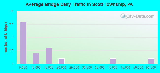
- 177,488Total average daily traffic
- 10,626Total average daily truck traffic
- National Bridge Inventory (NBI) Registered Bridges for Scott Township
- No street view available for this location
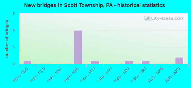
- New bridges - historical statistics
- 11920-1929
- 101950-1959
- 11960-1969
- 11980-1989
- 11990-1999
- 22010-2019
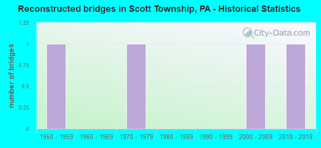
- Reconstructed bridges - Historical Statistics
- 11950-1959
- 01960-1969
- 11970-1979
- 01980-1989
- 01990-1999
- 12000-2009
- 12010-2019
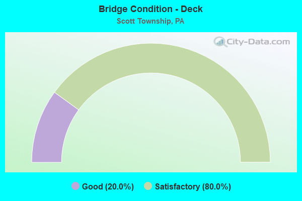
- Bridge Condition - Deck
- 20.0%Good
- 80.0%Satisfactory
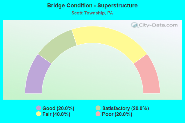
- Bridge Condition - Superstructure
- 20.0%Good
- 20.0%Satisfactory
- 40.0%Fair
- 20.0%Poor
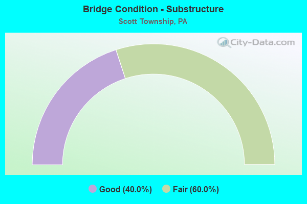
- Bridge Condition - Substructure
- 40.0%Good
- 60.0%Fair
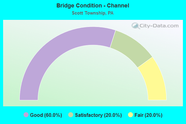
- Bridge Condition - Channel
- 60.0%Good
- 20.0%Satisfactory
- 20.0%Fair
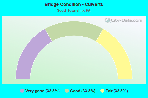
- Bridge Condition - Culverts
- 33.3%Very good
- 33.3%Good
- 33.3%Fair
Find on map >> Show street view
Structure Number: 703, Location: @ INT. W/HOPE HOLLOW ROAD (Lat: 40.395594, Lng: -80.086683), Route carried "on" structure: State highway 50, Year Built: 1965, Status: Open, Structure Length: 1.16m (3.81ft), Average Daily Traffic: 14,840 (year 2022), Truck Traffic: 7%, Average Future Daily Traffic: 18,518 (year 2032), Design Load: HS 20, Features Intersected: PGH & OHIO RAILWAY
Minimum Vertical Clearance: 30+ m (98+ ft), Kilometerpoint: 12.192, Lanes on structure: 5, Base Highway Network: Yes, Owner: State Highway Agency, Approaching Roadway Width: 22.6m (74.1ft), Skew: 4 degrees, Material/Design: Prestressed concrete, Design/Construction: Box Beam or Girders - Multiple, Number Of Spans In Main Unit: 1, Length of Maximum Span: 10.7m (35.1ft), Curb or Sidewalk Widths: Left: 1.8m (5.9ft), Right: 2.4m (7.9ft), Curb-To-Curb Width: 30.4m (99.7ft), Out-to-Out Width: 52.4m (171.9ft)
Condition: Deck: Satisfactory, Superstructure: Poor, Substructure: Fair, Inventory Rating: 83.5 metric tons, Method Used To Determine Inventory Rating: Load Factor (LF), Structural Evaluation: Meets minimum limits, Deck Geometry: Superior to present desirable criteria, Underclear: High priority of corrective action, Approach Roadway Alignment: Equal to present desirable criteria, Length Of Structure Improvement: 1.80m (5.91ft), Designated Inspection Frequency: Every 24 months, Inspection Date: October 2020, Bridge Improvement Cost: $60,000, Roadway Improvement Cost: $177,000, Total Project Cost: $810,000
Find on map >> Show street view
Structure Number: 2114, Location: CC17 CHARTIERS CRK # 17 (Lat: 40.371297, Lng: -80.096697), Route carried "on" structure: County highway , Year Built: 1984, Year Reconstructed: 2015, Status: Open, Structure Length: 6.28m (20.60ft), Average Daily Traffic: 9,615 (year 2006), Truck Traffic: 4%, Average Future Daily Traffic: 16,740 (year 2028), Design Load: HS 20, Features Intersected: CHARTIERS CREEK, Facility Carried by Structure: VANADIUM RD
Minimum Vertical Clearance: 30+ m (98+ ft), Kilometerpoint: 0.000, Lanes on structure: 2, Owner: County Highway Agency, Approaching Roadway Width: 10.4m (34.1ft), Skew: 3 degrees, Material/Design: Steel continuous, Design/Construction: Stringer/Multi-beam, Number Of Spans In Main Unit: 2, Length of Maximum Span: 31.1m (102.0ft), Curb or Sidewalk Widths: Left: 1.5m (4.9ft), Right: 0.2m (0.7ft), Curb-To-Curb Width: 10.4m (34.1ft), Out-to-Out Width: 13.3m (43.6ft)
Condition: Deck: Good, Superstructure: Satisfactory, Substructure: Good, Channel: Satisfactory, Operating Rating: 72.6 metric tons, Method Used To Determine Operating Rating: Load Factor (LF), Inventory Rating: 43.5 metric tons, Method Used To Determine Inventory Rating: Load Factor (LF), Structural Evaluation: Equal to present minimum criteria, Deck Geometry: Meets minimum limits, Waterway Adequacy: Superior to present desirable criteria, Approach Roadway Alignment: Equal to present minimum criteria, Length Of Structure Improvement: 6.30m (20.67ft), Designated Inspection Frequency: Every 24 months, Inspection Date: March 2021, Bridge Improvement Cost: $22,000, Roadway Improvement Cost: $66,000, Total Project Cost: $302,000, Deck Structure Type: Concrete Cast-file-Place, Wearing Surface/Protective System: Wearing Surface: Monolithic Concrete, Deck Protection: Epoxy Coated Reinforcing
Find on map >> Show street view
Structure Number: 225, Location: PA07 PAINTERS RUN NO. 7 (Lat: 40.363931, Lng: -80.087025), Route carried "on" structure: County highway , Year Built: 1927, Year Reconstructed: 1961, Status: Open, Structure Length: 0.94m (3.08ft), Average Daily Traffic: 15,909 (year 2005), Truck Traffic: 5%, Average Future Daily Traffic: 18,756 (year 2023), Features Intersected: PAINTERS RUN, Facility Carried by Structure: BOWER HILL RD
Minimum Vertical Clearance: 30+ m (98+ ft), Kilometerpoint: 0.000, Lanes on structure: 4, Owner: County Highway Agency, Approaching Roadway Width: 13.4m (44.0ft), Material/Design: Concrete, Design/Construction: Culvert, Number Of Spans In Main Unit: 2, Length of Maximum Span: 4.6m (15.1ft), Curb or Sidewalk Widths: Left: 2.1m (6.9ft), Right: 2.1m (6.9ft), Curb-To-Curb Width: 13.4m (44.0ft), Out-to-Out Width: 18.3m (60.0ft)
Condition: Channel: Fair, Culverts: Fair, Operating Rating: 53.5 metric tons, Method Used To Determine Operating Rating: Field evaluation and documented engineering judgment, Inventory Rating: 31.8 metric tons, Method Used To Determine Inventory Rating: Field evaluation and documented engineering judgment, Structural Evaluation: Somewhat better than minimum adequacy, Deck Geometry: High priority of replacement, Waterway Adequacy: Equal to present minimum criteria, Approach Roadway Alignment: Equal to present desirable criteria, Length Of Structure Improvement: 0.90m (2.95ft), Designated Inspection Frequency: Every 24 months, Inspection Date: April 2021, Bridge Improvement Cost: $9,000, Roadway Improvement Cost: $60,000, Total Project Cost: $118,000
Find on map >> Show street view
Structure Number: 2802, Location: CARNEGIE INTERCHANGE (Lat: 40.412314, Lng: -80.079967), Route carried "on" structure: Ramp State highway , Year Built: 1952, Year Reconstructed: 2008, Status: Open, Structure Length: 15.94m (52.30ft), Average Daily Traffic: 3,744 (year 2021), Truck Traffic: 7%, Average Future Daily Traffic: 5,116 (year 2032), Design Load: HS 20, Features Intersected: SR 50 & JANE STREET, Facility Carried by Structure: RAMP E
Minimum Vertical Clearance: 12.19m (39.99ft), Kilometerpoint: 0.000, Lanes on structure: 1, Lanes under structure: 6, Base Highway Network: Yes, Owner: State Highway Agency, Approaching Roadway Width: 7.9m (25.9ft), Skew: 6 degrees, Material/Design: Steel, Design/Construction: Girder and Floorbeam System, Number Of Spans In Main Unit: 7, Length of Maximum Span: 35.7m (117.1ft), Curb or Sidewalk Widths: Left: 0.2m (0.7ft), Right: 0.2m (0.7ft), Curb-To-Curb Width: 5.4m (17.7ft), Out-to-Out Width: 6.6m (21.7ft)
Condition: Deck: Satisfactory, Superstructure: Fair, Substructure: Fair, Operating Rating: 43.5 metric tons, Method Used To Determine Operating Rating: Load Factor (LF), Inventory Rating: 26.3 metric tons, Method Used To Determine Inventory Rating: Load Factor (LF), Structural Evaluation: Somewhat better than minimum adequacy, Deck Geometry: High priority of corrective action, Underclear: High priority of corrective action, Approach Roadway Alignment: Equal to present minimum criteria, Length Of Structure Improvement: 15.90m (52.17ft), Designated Inspection Frequency: Every 24 months, Critical Feature Inspection Frequency: Every 24 months, Inspection Date: July 2021, Critical Feature Inspection Date: July 2021, Bridge Improvement Cost: $40,000, Roadway Improvement Cost: $117,000, Total Project Cost: $537,000, Deck Structure Type: Concrete Cast-file-Place, Wearing Surface/Protective System: Wearing Surface: Low Slump Concrete, Membrane: Preformed Fabric, Deck Protection: Epoxy Coated Reinforcing
Find on map >> Show street view
Structure Number: 2805, Location: CARNEGIE INTERCHANGE (Lat: 40.412228, Lng: -80.078300), Route carried "on" structure: Ramp State highway , Year Built: 1952, Year Reconstructed: 1976, Status: Open, Structure Length: 5.24m (17.19ft), Average Daily Traffic: 4,991 (year 2021), Truck Traffic: 7%, Average Future Daily Traffic: 8,001 (year 2032), Design Load: HS 20, Features Intersected: SR 0376 EB WB, Facility Carried by Structure: RAMP D
Minimum Vertical Clearance: 30+ m (98+ ft), Kilometerpoint: 0.000, Lanes on structure: 1, Lanes under structure: 10, Base Highway Network: Yes, Owner: State Highway Agency, Approaching Roadway Width: 10.4m (34.1ft), Skew: 3 degrees, Material/Design: Steel, Design/Construction: Girder and Floorbeam System, Number Of Spans In Main Unit: 3, Length of Maximum Span: 30.2m (99.1ft), Curb or Sidewalk Widths: Left: 0.2m (0.7ft), Right: 0.2m (0.7ft), Curb-To-Curb Width: 9.1m (29.9ft), Out-to-Out Width: 10.1m (33.1ft)
Condition: Deck: Satisfactory, Superstructure: Fair, Substructure: Fair, Operating Rating: 49.9 metric tons, Method Used To Determine Operating Rating: Load Factor (LF), Inventory Rating: 29.9 metric tons, Method Used To Determine Inventory Rating: Load Factor (LF), Structural Evaluation: Somewhat better than minimum adequacy, Deck Geometry: Superior to present desirable criteria, Underclear: High priority of corrective action, Approach Roadway Alignment: Equal to present desirable criteria, Length Of Structure Improvement: 5.20m (17.06ft), Designated Inspection Frequency: Every 24 months, Critical Feature Inspection Frequency: Every 24 months, Inspection Date: November 2019, Critical Feature Inspection Date: November 2019, Bridge Improvement Cost: $8,000, Roadway Improvement Cost: $25,000, Total Project Cost: $113,000, Deck Structure Type: Concrete Cast-file-Place, Wearing Surface/Protective System: Wearing Surface: Monolithic Concrete, Deck Protection: Epoxy Coated Reinforcing
Find on map >> Show street view
Structure Number: 48096, Location: 0.6 MI SE OF SR3052 (Lat: 40.380422, Lng: -80.085106), Route carried "on" structure: State highway , Year Built: 2013, Status: Open, Structure Length: 1.01m (3.31ft), Average Daily Traffic: 5,825 (year 2020), Average Future Daily Traffic: 13,200 (year 2039), Design Load: HL 93, Features Intersected: SCRUBGRASS RUN, Facility Carried by Structure: SCRUBGRASS ROAD
Minimum Vertical Clearance: 30+ m (98+ ft), Kilometerpoint: 0.940, Lanes on structure: 2, Owner: State Highway Agency, Approaching Roadway Width: 11.0m (36.1ft), Skew: 6 degrees, Material/Design: Concrete, Design/Construction: Culvert, Number Of Spans In Main Unit: 1, Length of Maximum Span: 8.8m (28.9ft)
Condition: Channel: Good, Culverts: Very good, Operating Rating: 63.5 metric tons, Method Used To Determine Operating Rating: Assigned ratings based on Load and Resistance Factor Design (LRFD) reported by rating factor (RF) using HL93 loadings, Inventory Rating: 39.5 metric tons, Method Used To Determine Inventory Rating: Assigned ratings based on Load and Resistance Factor Design (LRFD) reported by rating factor (RF) using HL93 loadings, Structural Evaluation: Equal to present desirable criteria, Waterway Adequacy: Better than present minimum criteria, Approach Roadway Alignment: Equal to present desirable criteria, Designated Inspection Frequency: Every 48 months, Inspection Date: November 2020
Find on map >> Show street view
Structure Number: 49135, Location: Lindsay & Hope Hollow Rd (Lat: 40.393708, Lng: -80.082800), Route carried "on" structure: City street , Year Built: 1995, Status: Open, Structure Length: 1.10m (3.61ft), Average Daily Traffic: 200 (year 2015), Truck Traffic: 4%, Average Future Daily Traffic: 400 (year 2035), Design Load: HS 20, Features Intersected: Unnamed Tributary, Facility Carried by Structure: Lindsay Rd
Minimum Vertical Clearance: 30+ m (98+ ft), Kilometerpoint: 0.000, Lanes on structure: 2, Owner: Town or Township Highway Agency, Approaching Roadway Width: 6.1m (20.0ft), Material/Design: Steel, Design/Construction: Stringer/Multi-beam, Number Of Spans In Main Unit: 1, Length of Maximum Span: 11.0m (36.1ft), Curb or Sidewalk Widths: Left: 0.0m, Right: 1.5m (4.9ft), Curb-To-Curb Width: 7.3m (24.0ft), Out-to-Out Width: 7.3m (24.0ft)
Condition: Deck: Satisfactory, Superstructure: Good, Substructure: Good, Channel: Good, Operating Rating: 75.3 metric tons, Method Used To Determine Operating Rating: Load Factor (LF), Inventory Rating: 45.4 metric tons, Method Used To Determine Inventory Rating: Load Factor (LF), Structural Evaluation: Better than present minimum criteria, Deck Geometry: Somewhat better than minimum adequacy, Waterway Adequacy: Better than present minimum criteria, Approach Roadway Alignment: Equal to present minimum criteria, Designated Inspection Frequency: Every 24 months, Inspection Date: May 2021, Deck Structure Type: Concrete Cast-file-Place, Wearing Surface/Protective System: Wearing Surface: Monolithic Concrete
Find on map >> Show street view
Structure Number: 55973, Location: Idlewood Avenue (Lat: 40.414600, Lng: -80.076694), Route carried "on" structure: City street , Year Built: 2018, Status: Open, Structure Length: 0.67m (2.20ft), Average Daily Traffic: 175 (year 2018), Truck Traffic: 1%, Average Future Daily Traffic: 200 (year 2039), Design Load: HS 20, Features Intersected: Whiskey Run, Facility Carried by Structure: Idlewood Avenue
Minimum Vertical Clearance: 30+ m (98+ ft), Kilometerpoint: 0.000, Lanes on structure: 2, Owner: Town or Township Highway Agency, Approaching Roadway Width: 6.7m (22.0ft), Skew: 2 degrees, Material/Design: Concrete, Design/Construction: Culvert, Number Of Spans In Main Unit: 1, Length of Maximum Span: 6.1m (20.0ft), Curb or Sidewalk Widths: Left: 1.4m (4.6ft), Right: 1.4m (4.6ft), Curb-To-Curb Width: 6.7m (22.0ft), Out-to-Out Width: 6.7m (22.0ft)
Condition: Channel: Good, Culverts: Good, Operating Rating: 78.0 metric tons, Method Used To Determine Operating Rating: Load and Resistance Factor (LRFR), Inventory Rating: 46.3 metric tons, Method Used To Determine Inventory Rating: Load and Resistance Factor (LRFR), Structural Evaluation: Better than present minimum criteria, Deck Geometry: Meets minimum limits, Waterway Adequacy: Equal to present minimum criteria, Approach Roadway Alignment: Equal to present desirable criteria, Designated Inspection Frequency: Every 24 months, Inspection Date: October 2020, Wearing Surface/Protective System: Wearing Surface: Bituminous
Find on map >> Show street view
Structure Number: 977, Location: OVER SR50,RMPS.E&A,RR,CK (Lat: 40.412683, Lng: -80.079131), Route carried "under" structure: Ramp State highway , Year Built: 1950, Structure Length: 0. m, Average Daily Traffic: 1,818 (year 2021), Truck Traffic: 7%, Features Intersected: SR50,WLE RR,CHARTIERS CK, Facility Carried by Structure: PENN LINC PW
Minimum Vertical Clearance: 4.57m (14.99ft), Kilometerpoint: 0.000, Lanes on structure: 2, Lanes under structure: 1, Material/Design: Steel, Design/Construction: Stringer/Multi-beam, Length of Maximum Span: 30.8m (101.0ft)
Find on map >> Show street view
Structure Number: 977, Location: OVER SR50,RMPS.E&A,RR,CK (Lat: 40.412683, Lng: -80.079131), Route carried "under" structure: Ramp State highway , Year Built: 1950, Structure Length: 0. m, Average Daily Traffic: 3,744 (year 2021), Truck Traffic: 7%, Features Intersected: SR50,WLE RR,CHARTIERS CK, Facility Carried by Structure: PENN LINC PW
Minimum Vertical Clearance: 4.94m (16.21ft), Kilometerpoint: 0.000, Lanes on structure: 2, Lanes under structure: 1, Material/Design: Steel, Design/Construction: Stringer/Multi-beam, Length of Maximum Span: 30.8m (101.0ft)
Find on map >> Show street view
Structure Number: 977, Location: OVER SR50,RMPS.E&A,RR,CK (Lat: 40.412683, Lng: -80.079131), Route carried "under" structure: State highway 50, Year Built: 1950, Structure Length: 0. m, Average Daily Traffic: 10,935 (year 2022), Truck Traffic: 5%, Features Intersected: SR50,WLE RR,CHARTIERS CK, Facility Carried by Structure: PENN LINC PW
Minimum Vertical Clearance: 10.58m (34.71ft), Kilometerpoint: 14.610, Lanes on structure: 2, Lanes under structure: 2, Material/Design: Steel, Design/Construction: Stringer/Multi-beam, Length of Maximum Span: 30.8m (101.0ft)
Find on map >> Show street view
Structure Number: 98, Location: BELOW N&W RR TRESTLE (Lat: 40.410653, Lng: -80.073464), Route carried "under" structure: City street , Year Built: 1953, Structure Length: 0. m, Average Daily Traffic: 50 (year 2021), Truck Traffic: 1%, Features Intersected: WHISKEY RUN, BELL RD, Facility Carried by Structure: PENN LINCOLN PW
Minimum Vertical Clearance: 9.11m (29.89ft), Kilometerpoint: 0.000, Lanes on structure: 2, Lanes under structure: 2, Material/Design: Steel continuous, Design/Construction: Stringer/Multi-beam, Length of Maximum Span: 26.8m (87.9ft)
Find on map >> Show street view
Structure Number: 2802, Location: CARNEGIE INTERCHANGE (Lat: 40.412314, Lng: -80.079967), Route carried "under" structure: City street , Year Built: 1952, Structure Length: 0. m, Average Daily Traffic: 500 (year 2005), Truck Traffic: 1%, Features Intersected: SR 50 & JANE STREET, Facility Carried by Structure: RAMP E
Minimum Vertical Clearance: 4.34m (14.24ft), Kilometerpoint: 0.000, Lanes on structure: 1, Lanes under structure: 3, Material/Design: Steel, Design/Construction: Girder and Floorbeam System, Length of Maximum Span: 35.7m (117.1ft)
Find on map >> Show street view
Structure Number: 2802, Location: CARNEGIE INTERCHANGE (Lat: 40.412314, Lng: -80.079967), Route carried "under" structure: State highway 50, Year Built: 1952, Structure Length: 0. m, Average Daily Traffic: 10,935 (year 2022), Truck Traffic: 5%, Features Intersected: SR 50 & JANE STREET, Facility Carried by Structure: RAMP E
Minimum Vertical Clearance: 4.78m (15.68ft), Kilometerpoint: 14.610, Lanes on structure: 1, Lanes under structure: 3, Material/Design: Steel, Design/Construction: Girder and Floorbeam System, Length of Maximum Span: 35.7m (117.1ft)
Find on map >> Show street view
Structure Number: 2805, Location: CARNEGIE INTERCHANGE (Lat: 40.412228, Lng: -80.078300), Route carried "under" structure: Interstate 376, Year Built: 1952, Structure Length: 0. m, Average Daily Traffic: 39,825 (year 2022), Truck Traffic: 9%, Features Intersected: SR 0376 EB WB, Facility Carried by Structure: RAMP D
Minimum Vertical Clearance: 4.82m (15.81ft), Kilometerpoint: 25.424, Lanes on structure: 1, Lanes under structure: 5, Material/Design: Steel, Design/Construction: Girder and Floorbeam System, Length of Maximum Span: 30.2m (99.1ft)
Find on map >> Show street view
Structure Number: 2805, Location: CARNEGIE INTERCHANGE (Lat: 40.412228, Lng: -80.078300), Route carried "under" structure: Interstate 376, Year Built: 1952, Structure Length: 0. m, Average Daily Traffic: 54,382 (year 2022), Truck Traffic: 5%, Features Intersected: SR 0376 EB WB, Facility Carried by Structure: RAMP D
Minimum Vertical Clearance: 4.82m (15.81ft), Kilometerpoint: 25.424, Lanes on structure: 1, Lanes under structure: 5, Material/Design: Steel, Design/Construction: Girder and Floorbeam System, Length of Maximum Span: 30.2m (99.1ft)