Bridge Statistics for Scottsville, Virginia (VA)
Condition, Traffic, Stress, Structural Evaluation, Project Costs
- National Bridge Inventory (NBI) Statistics
- 10Number of bridges
- 148ft / 44.6mTotal length
- $1,735,000Total costs
- 13,238Total average daily traffic
- 702Total average daily truck traffic
- 18,214Total future (year 2039) average daily traffic
- National Bridge Inventory (NBI) Registered Bridges for Scottsville
- No street view available for this location
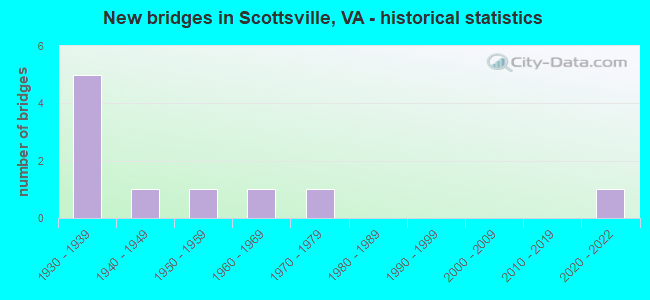
- New bridges - historical statistics
- 51930-1939
- 11940-1949
- 11950-1959
- 11960-1969
- 11970-1979
- 12020-2022

- Reconstructed bridges - Historical Statistics
- 11990-1999
- 22000-2009


- Bridge Condition - Deck
- 11.1%Excellent
- 11.1%Good
- 33.3%Satisfactory
- 44.4%Fair

- Bridge Condition - Superstructure
- 11.1%Excellent
- 11.1%Very good
- 22.2%Good
- 33.3%Satisfactory
- 22.2%Fair

- Bridge Condition - Substructure
- 11.1%Excellent
- 11.1%Good
- 33.3%Satisfactory
- 44.4%Fair

- Bridge Condition - Channel
- 10.0%Good
- 50.0%Satisfactory
- 40.0%Fair
Find on map >> Show street view
Structure Number: 407, Location: 1.56 FR 626 & 0.73 TO 20 (Lat: 37.808094, Lng: -78.511958), Route carried "on" structure: State highway 6, Year Built: 1935, Status: Open, Structure Length: 1.01m (3.31ft), Average Daily Traffic: 1,087 (year 2020), Truck Traffic: 6%, Average Future Daily Traffic: 1,119 (year 2040), Design Load: H 15, Features Intersected: MILLER CREEK, Facility Carried by Structure: IRISH ROAD
Minimum Vertical Clearance: 30+ m (98+ ft), Kilometerpoint: 56.692, Lanes on structure: 2, Owner: State Highway Agency, Approaching Roadway Width: 6.1m (20.0ft), Material/Design: Concrete, Design/Construction: Tee Beam, Number Of Spans In Main Unit: 1, Length of Maximum Span: 10.1m (33.1ft), Curb or Sidewalk Widths: Left: 0.2m (0.7ft), Right: 0.2m (0.7ft), Curb-To-Curb Width: 7.0m (23.0ft), Out-to-Out Width: 7.7m (25.3ft)
Condition: Deck: Fair, Superstructure: Fair, Substructure: Fair, Channel: Fair, Operating Rating: 48.1 metric tons, Method Used To Determine Operating Rating: Load Factor (LF), Inventory Rating: 28.1 metric tons, Method Used To Determine Inventory Rating: Load Factor (LF), Structural Evaluation: Somewhat better than minimum adequacy, Deck Geometry: High priority of corrective action, Waterway Adequacy: Equal to present minimum criteria, Approach Roadway Alignment: Equal to present minimum criteria, Length Of Structure Improvement: 1.01m (3.31ft), Designated Inspection Frequency: Every 24 months, Inspection Date: April 2020, Bridge Improvement Cost: $310,000, Roadway Improvement Cost: $100,000, Total Project Cost: $445,000, Deck Structure Type: Concrete Cast-file-Place, Wearing Surface/Protective System: Wearing Surface: Bituminous
Find on map >> Show street view
Structure Number: 408, Location: 1.29 FR 626 / 1.00 TO 20 (Lat: 37.808231, Lng: -78.517125), Route carried "on" structure: State highway 6, Year Built: 1935, Status: Open, Structure Length: 1.46m (4.79ft), Average Daily Traffic: 1,087 (year 2020), Truck Traffic: 6%, Average Future Daily Traffic: 1,119 (year 2040), Design Load: H 15, Features Intersected: TOTIER CREEK, Facility Carried by Structure: IRISH ROAD
Minimum Vertical Clearance: 30+ m (98+ ft), Kilometerpoint: 56.252, Lanes on structure: 2, Owner: State Highway Agency, Approaching Roadway Width: 6.1m (20.0ft), Material/Design: Concrete, Design/Construction: Tee Beam, Number Of Spans In Main Unit: 1, Length of Maximum Span: 14.6m (47.9ft), Curb or Sidewalk Widths: Left: 0.2m (0.7ft), Right: 0.2m (0.7ft), Curb-To-Curb Width: 6.9m (22.6ft), Out-to-Out Width: 7.7m (25.3ft)
Condition: Deck: Fair, Superstructure: Satisfactory, Substructure: Fair, Channel: Fair, Operating Rating: 44.5 metric tons, Method Used To Determine Operating Rating: Load Factor (LF), Inventory Rating: 26.3 metric tons, Method Used To Determine Inventory Rating: Load Factor (LF), Structural Evaluation: Somewhat better than minimum adequacy, Deck Geometry: High priority of corrective action, Waterway Adequacy: Equal to present minimum criteria, Approach Roadway Alignment: Equal to present minimum criteria, Length Of Structure Improvement: 1.46m (4.79ft), Designated Inspection Frequency: Every 24 months, Inspection Date: April 2021, Bridge Improvement Cost: $375,000, Roadway Improvement Cost: $100,000, Total Project Cost: $510,000, Deck Structure Type: Concrete Cast-file-Place, Wearing Surface/Protective System: Wearing Surface: Bituminous
Find on map >> Show street view
Structure Number: 447, Location: 0.00BUCKHMCO/O.OOALBEMCO (Lat: 37.795014, Lng: -78.493075), Route carried "on" structure: State highway 20, Year Built: 1968, Status: Open, Structure Length: 30.69m (100.69ft), Average Daily Traffic: 4,908 (year 2020), Truck Traffic: 6%, Average Future Daily Traffic: 6,852 (year 2040), Design Load: HS 20+Mod, Features Intersected: JAMES RIVER & CSX TRANS., Facility Carried by Structure: CONSTITUTION ROUTE
Minimum Vertical Clearance: 30+ m (98+ ft), Kilometerpoint: 30.603, Lanes on structure: 2, Owner: State Highway Agency, Approaching Roadway Width: 6.1m (20.0ft), Material/Design: Steel, Design/Construction: Stringer/Multi-beam, Number Of Spans In Main Unit: 5, Number Of Approach Spans: 5, Length of Maximum Span: 36.0m (118.1ft), Curb or Sidewalk Widths: Left: 1.5m (4.9ft), Right: 0.5m (1.6ft), Curb-To-Curb Width: 8.5m (27.9ft), Out-to-Out Width: 11.3m (37.1ft)
Condition: Deck: Fair, Superstructure: Fair, Substructure: Fair, Channel: Satisfactory, Operating Rating: 47.2 metric tons, Method Used To Determine Operating Rating: Load and Resistance Factor (LRFR), Inventory Rating: 36.3 metric tons, Method Used To Determine Inventory Rating: Load and Resistance Factor (LRFR), Structural Evaluation: Somewhat better than minimum adequacy, Deck Geometry: Meets minimum limits, Underclear: Better than present minimum criteria, Waterway Adequacy: Meets minimum limits, Approach Roadway Alignment: Equal to present desirable criteria, Designated Inspection Frequency: Every 24 months, Underwater Inspection Frequency: Every 60 months, Inspection Date: June 2020, Underwater Inspection Date: October 2017, Deck Structure Type: Concrete Cast-file-Place, Wearing Surface/Protective System: Wearing Surface: Epoxy Overlay
Find on map >> Show street view
Structure Number: 823, Location: 1.19 FR 6 / 0.50 TO 726 (Lat: 37.805142, Lng: -78.511342), Route carried "on" structure: County highway 737, Year Built: 1932, Year Reconstructed: 2000, Status: Open, Structure Length: 0.91m (2.99ft), Average Daily Traffic: 28 (year 2018), Average Future Daily Traffic: 31 (year 2040), Design Load: H 15, Features Intersected: MILLER CREEK, Facility Carried by Structure: MOUNTAIN VISTA RD.
Minimum Vertical Clearance: 30+ m (98+ ft), Kilometerpoint: 1.923, Lanes on structure: 1, Owner: State Highway Agency, Approaching Roadway Width: 4.0m (13.1ft), Skew: 1 degrees, Material/Design: Steel, Design/Construction: Stringer/Multi-beam, Number Of Spans In Main Unit: 1, Length of Maximum Span: 9.1m (29.9ft), Curb-To-Curb Width: 3.7m (12.1ft), Out-to-Out Width: 4.9m (16.1ft)
Condition: Deck: Good, Superstructure: Very good, Substructure: Satisfactory, Channel: Satisfactory, Operating Rating: 49.0 metric tons, Method Used To Determine Operating Rating: Load and Resistance Factor (LRFR), Inventory Rating: 38.1 metric tons, Method Used To Determine Inventory Rating: Load and Resistance Factor (LRFR), Structural Evaluation: Equal to present minimum criteria, Deck Geometry: Meets minimum limits, Waterway Adequacy: Somewhat better than minimum adequacy, Approach Roadway Alignment: Equal to present minimum criteria, Length Of Structure Improvement: 1.07m (3.51ft), Designated Inspection Frequency: Every 24 months, Inspection Date: July 2020, Bridge Improvement Cost: $150,000, Roadway Improvement Cost: $40,000, Total Project Cost: $210,000, Deck Structure Type: Wood or Timber
Find on map >> Show street view
Structure Number: 824, Location: 0.97 FR 6 / 0.73 TO 726 (Lat: 37.804558, Lng: -78.514906), Route carried "on" structure: County highway 737, Year Built: 1932, Year Reconstructed: 1997, Status: Open, Structure Length: 0.98m (3.22ft), Average Daily Traffic: 28 (year 2018), Average Future Daily Traffic: 31 (year 2040), Features Intersected: TOTIER CREEK, Facility Carried by Structure: MOUNTAIN VISTA RD.
Minimum Vertical Clearance: 30+ m (98+ ft), Kilometerpoint: 1.567, Lanes on structure: 1, Owner: State Highway Agency, Approaching Roadway Width: 4.3m (14.1ft), Material/Design: Steel, Design/Construction: Stringer/Multi-beam, Number Of Spans In Main Unit: 1, Length of Maximum Span: 9.8m (32.2ft), Curb-To-Curb Width: 3.7m (12.1ft), Out-to-Out Width: 4.9m (16.1ft)
Condition: Deck: Satisfactory, Superstructure: Good, Substructure: Fair, Channel: Satisfactory, Operating Rating: 51.7 metric tons, Method Used To Determine Operating Rating: Load and Resistance Factor (LRFR), Inventory Rating: 39.9 metric tons, Method Used To Determine Inventory Rating: Load and Resistance Factor (LRFR), Structural Evaluation: Somewhat better than minimum adequacy, Deck Geometry: Meets minimum limits, Waterway Adequacy: Somewhat better than minimum adequacy, Approach Roadway Alignment: Equal to present minimum criteria, Length Of Structure Improvement: 1.46m (4.79ft), Designated Inspection Frequency: Every 24 months, Inspection Date: July 2020, Bridge Improvement Cost: $175,000, Roadway Improvement Cost: $60,000, Total Project Cost: $250,000, Deck Structure Type: Wood or Timber
Find on map >> Show street view
Structure Number: 4014, Location: 3.47-Albe.Co/15.58 -Rt.15 (Lat: 37.747447, Lng: -78.490647), Route carried "on" structure: State highway 20, Year Built: 1930, Status: Open, Structure Length: 0.69m (2.26ft), Average Daily Traffic: 4,267 (year 2020), Truck Traffic: 6%, Average Future Daily Traffic: 5,974 (year 2040), Features Intersected: Little Georgia Creek, Facility Carried by Structure: Constitution Route
Minimum Vertical Clearance: 30+ m (98+ ft), Kilometerpoint: 25.062, Lanes on structure: 2, Owner: State Highway Agency, Approaching Roadway Width: 6.7m (22.0ft), Material/Design: Concrete, Design/Construction: Slab, Number Of Spans In Main Unit: 1, Length of Maximum Span: 6.2m (20.3ft), Curb or Sidewalk Widths: Left: 0.4m (1.3ft), Right: 0.4m (1.3ft), Curb-To-Curb Width: 7.0m (23.0ft), Out-to-Out Width: 8.1m (26.6ft)
Condition: Deck: Satisfactory, Superstructure: Satisfactory, Substructure: Good, Channel: Fair, Operating Rating: 41.7 metric tons, Method Used To Determine Operating Rating: Load Factor (LF), Inventory Rating: 24.5 metric tons, Method Used To Determine Inventory Rating: Load Factor (LF), Structural Evaluation: Equal to present minimum criteria, Deck Geometry: High priority of replacement, Waterway Adequacy: Better than present minimum criteria, Approach Roadway Alignment: Equal to present desirable criteria, Length Of Structure Improvement: 1.22m (4.00ft), Designated Inspection Frequency: Every 24 months, Inspection Date: August 2020, Bridge Improvement Cost: $213,000, Roadway Improvement Cost: $21,000, Total Project Cost: $320,000, Deck Structure Type: Concrete Cast-file-Place, Wearing Surface/Protective System: Wearing Surface: Bituminous
Find on map >> Show street view
Structure Number: 4117, Location: 1.50-Rt. 20 / 1.50-Rt.784 (Lat: 37.751014, Lng: -78.466803), Route carried "on" structure: County highway 679, Year Built: 1974, Status: Open, Structure Length: 0.67m (2.20ft), Average Daily Traffic: 111 (year 2018), Average Future Daily Traffic: 158 (year 2040), Design Load: HS 20, Features Intersected: Little Georgia Creek, Facility Carried by Structure: Payne's Pond Rd.
Minimum Vertical Clearance: 30+ m (98+ ft), Kilometerpoint: 4.177, Lanes on structure: 2, Owner: State Highway Agency, Approaching Roadway Width: 4.6m (15.1ft), Skew: 2 degrees, Material/Design: Concrete, Design/Construction: Culvert, Number Of Spans In Main Unit: 2, Length of Maximum Span: 3.2m (10.5ft)
Condition: Channel: Fair, Culverts: Good, Operating Rating: 69.9 metric tons, Method Used To Determine Operating Rating: Load Factor (LF), Inventory Rating: 41.7 metric tons, Method Used To Determine Inventory Rating: Load Factor (LF), Structural Evaluation: Better than present minimum criteria, Waterway Adequacy: Better than present minimum criteria, Approach Roadway Alignment: Equal to present minimum criteria, Designated Inspection Frequency: Every 24 months, Inspection Date: October 2020
Find on map >> Show street view
Structure Number: 77, Location: 0.40ALBEM CO/0.52 TO 1302 (Lat: 37.823969, Lng: -78.464461), Route carried "on" structure: County highway 622, Year Built: 1948, Year Reconstructed: 2007, Status: Posted for load, Structure Length: 1.25m (4.10ft), Average Daily Traffic: 502 (year 2020), Average Future Daily Traffic: 700 (year 2040), Design Load: HS 20+Mod, Features Intersected: HARDWARE RIVER, Facility Carried by Structure: ALBEVANNA SPRGS RD
Minimum Vertical Clearance: 30+ m (98+ ft), Kilometerpoint: 0.644, Lanes on structure: 1, Owner: State Highway Agency, Approaching Roadway Width: 4.3m (14.1ft), Material/Design: Steel, Design/Construction: Stringer/Multi-beam, Number Of Spans In Main Unit: 1, Length of Maximum Span: 11.3m (37.1ft), Curb-To-Curb Width: 4.1m (13.5ft), Out-to-Out Width: 4.4m (14.4ft)
Condition: Deck: Satisfactory, Superstructure: Good, Substructure: Satisfactory, Channel: Satisfactory, Operating Rating: 22.7 metric tons, Method Used To Determine Operating Rating: Field evaluation and documented engineering judgment, Inventory Rating: 16.3 metric tons, Method Used To Determine Inventory Rating: Field evaluation and documented engineering judgment, Structural Evaluation: Meets minimum limits, Deck Geometry: High priority of replacement, Waterway Adequacy: Meets minimum limits, Approach Roadway Alignment: Meets minimum limits, Bridge Posting: Required (Relationship of Operating Rating to Maximum Legal Load: 10.0 - 19.9% below), Designated Inspection Frequency: Every 24 months, Inspection Date: July 2020, Deck Structure Type: Wood or Timber
Find on map >> Show street view
Structure Number: 7713, Location: 1.05 FR 773 / 1.10 TO 669 (Lat: 37.812436, Lng: -78.455306), Route carried "on" structure: County highway 637, Year Built: 1952, Status: Posted for load, Structure Length: 5.25m (17.22ft), Average Daily Traffic: 742 (year 2020), Truck Traffic: 3%, Average Future Daily Traffic: 760 (year 2040), Design Load: HS 15, Features Intersected: HARDWARE RIVER, Facility Carried by Structure: ANTIOCH ROAD
Minimum Vertical Clearance: 30+ m (98+ ft), Kilometerpoint: 4.425, Lanes on structure: 2, Owner: State Highway Agency, Approaching Roadway Width: 6.7m (22.0ft), Material/Design: Steel, Design/Construction: Stringer/Multi-beam, Number Of Spans In Main Unit: 3, Length of Maximum Span: 21.3m (69.9ft), Curb or Sidewalk Widths: Left: 0.3m (1.0ft), Right: 0.3m (1.0ft), Curb-To-Curb Width: 6.7m (22.0ft), Out-to-Out Width: 7.9m (25.9ft)
Condition: Deck: Fair, Superstructure: Satisfactory, Substructure: Satisfactory, Channel: Satisfactory, Operating Rating: 37.2 metric tons, Method Used To Determine Operating Rating: Load and Resistance Factor (LRFR), Inventory Rating: 28.1 metric tons, Method Used To Determine Inventory Rating: Load and Resistance Factor (LRFR), Structural Evaluation: Equal to present minimum criteria, Deck Geometry: Meets minimum limits, Waterway Adequacy: Superior to present desirable criteria, Approach Roadway Alignment: Equal to present minimum criteria, Bridge Posting: Required (Relationship of Operating Rating to Maximum Legal Load: 0.1 - 9.9% below), Designated Inspection Frequency: Every 24 months, Inspection Date: October 2021, Deck Structure Type: Concrete Cast-file-Place, Wearing Surface/Protective System: Wearing Surface: Latex Concrete
Find on map >> Show street view
Structure Number: 31038, Location: 1.38 FR 625 / 0.45 TO 845 (Lat: 37.792197, Lng: -78.520208), Route carried "on" structure: County highway 726, Year Built: 2021, Status: Open, Structure Length: 1.68m (5.51ft), Average Daily Traffic: 478 (year 2018), Average Future Daily Traffic: 1,470 (year 2039), Design Load: HL 93, Features Intersected: TOTIER CREEK, Facility Carried by Structure: JAMES RIVER ROAD
Minimum Vertical Clearance: 30.45m (99.90ft), Kilometerpoint: 4.795, Lanes on structure: 2, Owner: State Highway Agency, Approaching Roadway Width: 7.0m (23.0ft), Material/Design: Prestressed concrete, Design/Construction: Slab, Number Of Spans In Main Unit: 1, Length of Maximum Span: 16.8m (55.1ft), Curb-To-Curb Width: 6.7m (22.0ft), Out-to-Out Width: 8.8m (28.9ft)
Condition: Deck: Excellent, Superstructure: Excellent, Substructure: Excellent, Channel: Good, Operating Rating: 68.9 metric tons, Method Used To Determine Operating Rating: Load and Resistance Factor (LRFR), Inventory Rating: 52.6 metric tons, Method Used To Determine Inventory Rating: Load and Resistance Factor (LRFR), Structural Evaluation: Superior to present desirable criteria, Deck Geometry: Meets minimum limits, Waterway Adequacy: Equal to present desirable criteria, Approach Roadway Alignment: Equal to present minimum criteria, Designated Inspection Frequency: Every 24 months, Inspection Date: March 2021, Deck Structure Type: Other, Wearing Surface/Protective System: Wearing Surface: Bituminous, Membrane: Epoxy, Deck Protection: Other