Bridge Statistics for SeaTac, Washington (WA)
Condition, Traffic, Stress, Structural Evaluation, Project Costs
- National Bridge Inventory (NBI) Statistics
- 32Number of bridges
- 482ft / 147mTotal length
- $99,811,000Total costs
- 1,625,997Total average daily traffic
- 104,044Total average daily truck traffic
- National Bridge Inventory (NBI) Registered Bridges for SeaTac
- No street view available for this location
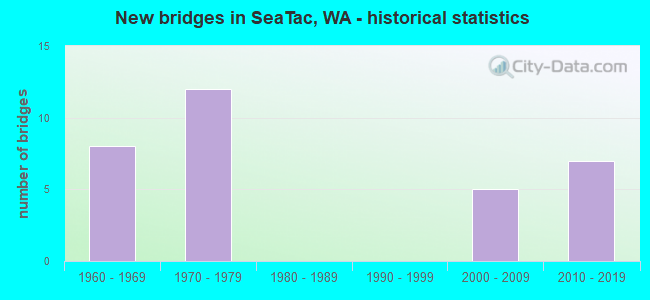
- New bridges - historical statistics
- 81960-1969
- 121970-1979
- 52000-2009
- 72010-2019
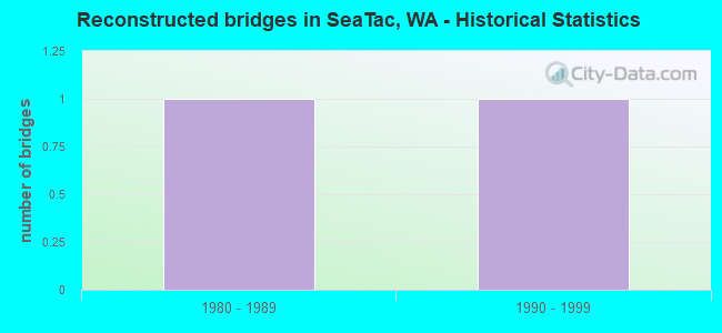
- Reconstructed bridges - Historical Statistics
- 11980-1989
- 11990-1999
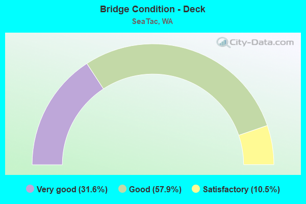
- Bridge Condition - Deck
- 31.6%Very good
- 57.9%Good
- 10.5%Satisfactory
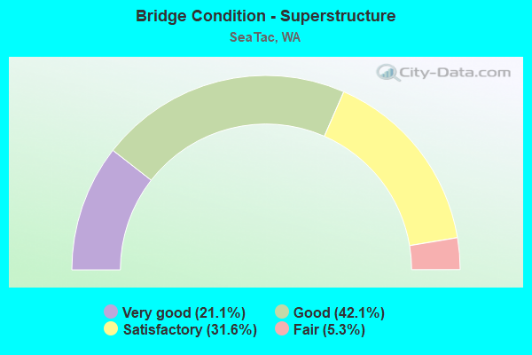
- Bridge Condition - Superstructure
- 21.1%Very good
- 42.1%Good
- 31.6%Satisfactory
- 5.3%Fair
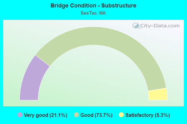
- Bridge Condition - Substructure
- 21.1%Very good
- 73.7%Good
- 5.3%Satisfactory
Find on map >> Show street view
Structure Number: 7075A, Location: 2.0 N JCT SR 516 (Lat: 47.420850, Lng: -122.287544), Route carried "on" structure: County highway , Year Built: 1963, Status: Open, Structure Length: 15.70m (51.51ft), Average Daily Traffic: 13,282 (year 2016), Truck Traffic: 1%, Average Future Daily Traffic: 20,801 (year 2038), Design Load: HS 20, Features Intersected: I-5, Facility Carried by Structure: MILITARY RD
Minimum Vertical Clearance: 30+ m (98+ ft), Kilometerpoint: 0.209, Lanes on structure: 2, Lanes under structure: 12, Owner: State Highway Agency, Approaching Roadway Width: 11.0m (36.1ft), Material/Design: Concrete continuous, Design/Construction: Box Beam or Girders - Multiple, Number Of Spans In Main Unit: 4, Length of Maximum Span: 44.5m (146.0ft), Curb or Sidewalk Widths: Left: 0.9m (3.0ft), Right: 0.9m (3.0ft), Curb-To-Curb Width: 7.9m (25.9ft), Out-to-Out Width: 10.4m (34.1ft)
Condition: Deck: Satisfactory, Superstructure: Satisfactory, Substructure: Good, Operating Rating: 73.5 metric tons, Method Used To Determine Operating Rating: Load Factor (LF), Inventory Rating: 43.5 metric tons, Method Used To Determine Inventory Rating: Load Factor (LF), Structural Evaluation: Equal to present minimum criteria, Deck Geometry: High priority of corrective action, Underclear: High priority of corrective action, Approach Roadway Alignment: Equal to present desirable criteria, Length Of Structure Improvement: 15.70m (51.51ft), Designated Inspection Frequency: Every 48 months, Inspection Date: October 2018, Bridge Improvement Cost: $3,914,000, Roadway Improvement Cost: $783,000, Total Project Cost: $7,828,000 ( Estimate for 2014), Deck Structure Type: Concrete Cast-file-Place, Wearing Surface/Protective System: Wearing Surface: Epoxy Overlay
Find on map >> Show street view
Structure Number: 7090A, Location: 1.1 N JCT SR 516 (Lat: 47.408194, Lng: -122.292583), Route carried "on" structure: City street , Year Built: 1963, Status: Open, Structure Length: 8.84m (29.00ft), Average Daily Traffic: 15,928 (year 2020), Truck Traffic: 1%, Average Future Daily Traffic: 26,414 (year 2040), Design Load: HS 20, Features Intersected: I-5, Facility Carried by Structure: S 216TH ST
Minimum Vertical Clearance: 30+ m (98+ ft), Kilometerpoint: 2.543, Lanes on structure: 2, Lanes under structure: 10, Owner: State Highway Agency, Approaching Roadway Width: 9.8m (32.2ft), Material/Design: Prestressed concrete, Design/Construction: Stringer/Multi-beam, Number Of Spans In Main Unit: 4, Length of Maximum Span: 26.5m (86.9ft), Curb or Sidewalk Widths: Left: 0.9m (3.0ft), Right: 0.9m (3.0ft), Curb-To-Curb Width: 8.5m (27.9ft), Out-to-Out Width: 11.0m (36.1ft)
Condition: Deck: Good, Superstructure: Good, Substructure: Good, Operating Rating: 65.3 metric tons, Method Used To Determine Operating Rating: Load Factor (LF), Inventory Rating: 38.1 metric tons, Method Used To Determine Inventory Rating: Load Factor (LF), Structural Evaluation: Better than present minimum criteria, Deck Geometry: Meets minimum limits, Underclear: Somewhat better than minimum adequacy, Approach Roadway Alignment: Equal to present desirable criteria, Length Of Structure Improvement: 8.84m (29.00ft), Designated Inspection Frequency: Every 48 months, Inspection Date: November 2019, Bridge Improvement Cost: $1,972,000, Roadway Improvement Cost: $394,000, Total Project Cost: $3,944,000 ( Estimate for 2014), Deck Structure Type: Concrete Cast-file-Place, Wearing Surface/Protective System: Wearing Surface: Monolithic Concrete
Find on map >> Show street view
Structure Number: 7090B, Location: 3.1 N JCT SR 516 (Lat: 47.431194, Lng: -122.271444), Route carried "on" structure: Interstate 5, Year Built: 1963, Year Reconstructed: 1994, Status: Open, Structure Length: 5.94m (19.49ft), Average Daily Traffic: 101,872 (year 2019), Truck Traffic: 8%, Average Future Daily Traffic: 143,843 (year 2039), Design Load: HS 20+Mod, Features Intersected: ORILLIA RD/S 188TH ST
Minimum Vertical Clearance: 30+ m (98+ ft), Kilometerpoint: 245.039, Lanes on structure: 5, Lanes under structure: 5, Base Highway Network: Yes, Owner: State Highway Agency, Approaching Roadway Width: 23.5m (77.1ft), Material/Design: Prestressed concrete, Design/Construction: Stringer/Multi-beam, Number Of Spans In Main Unit: 3, Length of Maximum Span: 25.0m (82.0ft), Curb-To-Curb Width: 23.6m (77.4ft), Out-to-Out Width: 24.1m (79.1ft)
Condition: Deck: Good, Superstructure: Satisfactory, Substructure: Good, Operating Rating: 43.5 metric tons, Method Used To Determine Operating Rating: Load Factor (LF), Inventory Rating: 26.3 metric tons, Method Used To Determine Inventory Rating: Load Factor (LF), Structural Evaluation: Equal to present minimum criteria, Deck Geometry: Equal to present minimum criteria, Underclear: Meets minimum limits, Approach Roadway Alignment: Equal to present desirable criteria, Length Of Structure Improvement: 5.94m (19.49ft), Designated Inspection Frequency: Every 24 months, Inspection Date: July 2021, Bridge Improvement Cost: $3,081,000, Roadway Improvement Cost: $616,000, Total Project Cost: $6,162,000 ( Estimate for 2014), Deck Structure Type: Concrete Cast-file-Place, Wearing Surface/Protective System: Wearing Surface: Latex Concrete, Deck Protection: Epoxy Coated Reinforcing
Find on map >> Show street view
Structure Number: 7090C, Location: 3.1 N JCT SR 516 (Lat: 47.431194, Lng: -122.271472), Route carried "on" structure: Interstate 5, Year Built: 1963, Year Reconstructed: 1997, Status: Open, Structure Length: 7.01m (23.00ft), Average Daily Traffic: 101,872 (year 2019), Truck Traffic: 8%, Average Future Daily Traffic: 143,843 (year 2039), Design Load: HS 20, Features Intersected: ORILLIA RD/S 188TH ST
Minimum Vertical Clearance: 30+ m (98+ ft), Kilometerpoint: 245.039, Lanes on structure: 5, Lanes under structure: 5, Base Highway Network: Yes, Owner: State Highway Agency, Approaching Roadway Width: 20.7m (67.9ft), Material/Design: Prestressed concrete, Design/Construction: Stringer/Multi-beam, Number Of Spans In Main Unit: 3, Length of Maximum Span: 22.6m (74.1ft), Curb-To-Curb Width: 28.0m (91.9ft), Out-to-Out Width: 28.6m (93.8ft)
Condition: Deck: Good, Superstructure: Good, Substructure: Good, Operating Rating: 54.4 metric tons, Method Used To Determine Operating Rating: Load Factor (LF), Inventory Rating: 40.8 metric tons, Method Used To Determine Inventory Rating: Load Factor (LF), Structural Evaluation: Better than present minimum criteria, Deck Geometry: Superior to present desirable criteria, Underclear: Meets minimum limits, Approach Roadway Alignment: Equal to present desirable criteria, Length Of Structure Improvement: 7.01m (23.00ft), Designated Inspection Frequency: Every 24 months, Inspection Date: July 2021, Bridge Improvement Cost: $3,220,000, Roadway Improvement Cost: $644,000, Total Project Cost: $6,440,000 ( Estimate for 2014), Deck Structure Type: Concrete Cast-file-Place, Wearing Surface/Protective System: Wearing Surface: Monolithic Concrete, Deck Protection: Epoxy Coated Reinforcing
Find on map >> Show street view
Structure Number: 7401A, Location: 4.0 N JCT SR 516 (Lat: 47.443889, Lng: -122.268611), Route carried "on" structure: County highway , Year Built: 1964, Status: Open, Structure Length: 9.81m (32.19ft), Average Daily Traffic: 13,400 (year 2002), Truck Traffic: 1%, Average Future Daily Traffic: 23,423 (year 2036), Design Load: HS 20, Features Intersected: I-5, Facility Carried by Structure: S178TH ST
Minimum Vertical Clearance: 30+ m (98+ ft), Kilometerpoint: 2.173, Lanes on structure: 2, Lanes under structure: 11, Owner: State Highway Agency, Approaching Roadway Width: 11.6m (38.1ft), Skew: 9 degrees, Material/Design: Prestressed concrete, Design/Construction: Stringer/Multi-beam, Number Of Spans In Main Unit: 4, Length of Maximum Span: 31.1m (102.0ft), Curb or Sidewalk Widths: Left: 0.9m (3.0ft), Right: 0.9m (3.0ft), Curb-To-Curb Width: 7.9m (25.9ft), Out-to-Out Width: 10.2m (33.5ft)
Condition: Deck: Good, Superstructure: Good, Substructure: Satisfactory, Operating Rating: 70.7 metric tons, Method Used To Determine Operating Rating: Load Factor (LF), Inventory Rating: 41.7 metric tons, Method Used To Determine Inventory Rating: Load Factor (LF), Structural Evaluation: Equal to present minimum criteria, Deck Geometry: High priority of corrective action, Underclear: High priority of corrective action, Approach Roadway Alignment: Equal to present desirable criteria, Length Of Structure Improvement: 9.81m (32.19ft), Designated Inspection Frequency: Every 24 months, Inspection Date: March 2020, Bridge Improvement Cost: $2,576,000, Roadway Improvement Cost: $515,000, Total Project Cost: $5,152,000 ( Estimate for 2014), Deck Structure Type: Concrete Cast-file-Place, Wearing Surface/Protective System: Wearing Surface: Monolithic Concrete
Find on map >> Show street view
Structure Number: 8644C, Location: 1.5 E JCT SR 509 (Lat: 47.465953, Lng: -122.302444), Route carried "on" structure: County highway , Year Built: 1970, Status: Open, Structure Length: 11.06m (36.29ft), Average Daily Traffic: 2,564 (year 2000), Truck Traffic: 5%, Average Future Daily Traffic: 5,144 (year 2032), Design Load: HS 20, Features Intersected: SR 518, RAMPS, Facility Carried by Structure: 24TH AVE S
Minimum Vertical Clearance: 30+ m (98+ ft), Kilometerpoint: 3.170, Lanes on structure: 2, Lanes under structure: 8, Owner: State Highway Agency, Approaching Roadway Width: 12.2m (40.0ft), Skew: 3 degrees, Material/Design: Prestressed concrete continuous, Design/Construction: Stringer/Multi-beam, Number Of Spans In Main Unit: 4, Length of Maximum Span: 35.7m (117.1ft), Curb or Sidewalk Widths: Left: 0.2m (0.7ft), Right: 0.2m (0.7ft), Curb-To-Curb Width: 11.6m (38.1ft), Out-to-Out Width: 12.3m (40.4ft)
Condition: Deck: Good, Superstructure: Satisfactory, Substructure: Good, Operating Rating: 52.6 metric tons, Method Used To Determine Operating Rating: Load Factor (LF), Inventory Rating: 30.8 metric tons, Method Used To Determine Inventory Rating: Load Factor (LF), Structural Evaluation: Equal to present minimum criteria, Deck Geometry: Somewhat better than minimum adequacy, Underclear: Somewhat better than minimum adequacy, Approach Roadway Alignment: Equal to present desirable criteria, Length Of Structure Improvement: 11.06m (36.29ft), Designated Inspection Frequency: Every 24 months, Inspection Date: March 2020, Bridge Improvement Cost: $3,049,000, Roadway Improvement Cost: $610,000, Total Project Cost: $6,098,000 ( Estimate for 2014), Deck Structure Type: Concrete Cast-file-Place, Wearing Surface/Protective System: Wearing Surface: Bituminous
Find on map >> Show street view
Structure Number: 8745F, Location: 1.6 E JCT SR 509 (Lat: 47.465139, Lng: -122.300361), Route carried "on" structure: County highway , Year Built: 1971, Status: Open, Structure Length: 16.95m (55.61ft), Average Daily Traffic: 8,626 (year 2016), Truck Traffic: 2%, Average Future Daily Traffic: 13,509 (year 2038), Design Load: HS 20, Features Intersected: SR 518, Facility Carried by Structure: S 154TH ST
Minimum Vertical Clearance: 30+ m (98+ ft), Kilometerpoint: 0.048, Lanes on structure: 2, Lanes under structure: 7, Owner: State Highway Agency, Approaching Roadway Width: 11.0m (36.1ft), Skew: 5 degrees, Material/Design: Steel continuous, Design/Construction: Stringer/Multi-beam, Number Of Spans In Main Unit: 5, Length of Maximum Span: 48.2m (158.1ft), Curb or Sidewalk Widths: Left: 0.0m, Right: 1.6m (5.2ft), Curb-To-Curb Width: 9.8m (32.2ft), Out-to-Out Width: 12.3m (40.4ft)
Condition: Deck: Very good, Superstructure: Good, Substructure: Good, Operating Rating: 58.0 metric tons, Method Used To Determine Operating Rating: Load Factor (LF), Inventory Rating: 35.4 metric tons, Method Used To Determine Inventory Rating: Load Factor (LF), Structural Evaluation: Better than present minimum criteria, Deck Geometry: Meets minimum limits, Underclear: Somewhat better than minimum adequacy, Approach Roadway Alignment: Equal to present desirable criteria, Length Of Structure Improvement: 16.95m (55.61ft), Designated Inspection Frequency: Every 24 months, Inspection Date: October 2020, Bridge Improvement Cost: $4,226,000, Roadway Improvement Cost: $845,000, Total Project Cost: $8,451,000 ( Estimate for 2014), Deck Structure Type: Concrete Cast-file-Place, Wearing Surface/Protective System: Wearing Surface: Bituminous
Find on map >> Show street view
Structure Number: 8902A, Location: 1.9 E JCT SR 509 (Lat: 47.462583, Lng: -122.294333), Route carried "on" structure: Ramp State highway 518, Year Built: 1971, Status: Open, Structure Length: 18.56m (60.89ft), Average Daily Traffic: 4,775 (year 2019), Truck Traffic: 5%, Average Future Daily Traffic: 6,742 (year 2039), Design Load: HS 20, Features Intersected: N-W RAMP, SR 518
Minimum Vertical Clearance: 30+ m (98+ ft), Kilometerpoint: 0.418, Lanes on structure: 2, Lanes under structure: 7, Owner: State Highway Agency, Approaching Roadway Width: 12.8m (42.0ft), Skew: 4 degrees, Material/Design: Concrete continuous, Design/Construction: Box Beam or Girders - Multiple, Number Of Spans In Main Unit: 7, Length of Maximum Span: 33.8m (110.9ft), Curb or Sidewalk Widths: Left: 0.2m (0.7ft), Right: 0.2m (0.7ft), Curb-To-Curb Width: 11.6m (38.1ft), Out-to-Out Width: 12.6m (41.3ft)
Condition: Deck: Good, Superstructure: Satisfactory, Substructure: Good, Operating Rating: 83.4 metric tons, Method Used To Determine Operating Rating: Load Factor (LF), Inventory Rating: 49.0 metric tons, Method Used To Determine Inventory Rating: Load Factor (LF), Structural Evaluation: Equal to present minimum criteria, Deck Geometry: Superior to present desirable criteria, Underclear: Somewhat better than minimum adequacy, Approach Roadway Alignment: Equal to present desirable criteria, Length Of Structure Improvement: 18.56m (60.89ft), Designated Inspection Frequency: Every 24 months, Inspection Date: September 2021, Bridge Improvement Cost: $5,359,000, Roadway Improvement Cost: $1,072,000, Total Project Cost: $10,718,000 ( Estimate for 2014), Deck Structure Type: Concrete Cast-file-Place, Wearing Surface/Protective System: Wearing Surface: Bituminous
Find on map >> Show street view
Structure Number: 8902B, Location: 1.9 E JCT SR 509 (Lat: 47.463589, Lng: -122.293767), Route carried "on" structure: State highway 518, Year Built: 1971, Status: Open, Structure Length: 3.87m (12.70ft), Average Daily Traffic: 56,636 (year 2019), Truck Traffic: 2%, Average Future Daily Traffic: 79,970 (year 2039), Design Load: HS 20, Features Intersected: W-S RAMP
Minimum Vertical Clearance: 30+ m (98+ ft), Kilometerpoint: 3.685, Lanes on structure: 5, Lanes under structure: 2, Base Highway Network: Yes, Owner: State Highway Agency, Approaching Roadway Width: 29.3m (96.1ft), Skew: 33 degrees, Material/Design: Prestressed concrete, Design/Construction: Stringer/Multi-beam, Number Of Spans In Main Unit: 1, Length of Maximum Span: 38.1m (125.0ft), Curb or Sidewalk Widths: Left: 0.2m (0.7ft), Right: 0.2m (0.7ft), Curb-To-Curb Width: 28.0m (91.9ft), Out-to-Out Width: 30.0m (98.4ft)
Condition: Deck: Good, Superstructure: Good, Substructure: Good, Operating Rating: 54.4 metric tons, Method Used To Determine Operating Rating: Load Factor (LF), Inventory Rating: 32.7 metric tons, Method Used To Determine Inventory Rating: Load Factor (LF), Structural Evaluation: Better than present minimum criteria, Deck Geometry: Superior to present desirable criteria, Underclear: Equal to present desirable criteria, Approach Roadway Alignment: Equal to present desirable criteria, Length Of Structure Improvement: 3.87m (12.70ft), Designated Inspection Frequency: Every 24 months, Inspection Date: August 2021, Bridge Improvement Cost: $2,489,000, Roadway Improvement Cost: $498,000, Total Project Cost: $4,978,000 ( Estimate for 2014), Deck Structure Type: Concrete Cast-file-Place, Wearing Surface/Protective System: Wearing Surface: Bituminous
Find on map >> Show street view
Structure Number: 11405A, Location: 4.7 N JCT SR516 (Lat: 47.438806, Lng: -122.322333), Route carried "on" structure: State highway 509, Year Built: 1979, Status: Open, Structure Length: 2.59m (8.50ft), Average Daily Traffic: 16,546 (year 2019), Truck Traffic: 6%, Average Future Daily Traffic: 23,362 (year 2039), Design Load: HS 20+Mod, Features Intersected: SR 509/DES MOINES MEM
Minimum Vertical Clearance: 30+ m (98+ ft), Kilometerpoint: 39.188, Lanes on structure: 2, Lanes under structure: 4, Base Highway Network: Yes, Owner: State Highway Agency, Approaching Roadway Width: 17.1m (56.1ft), Skew: 31 degrees, Material/Design: Prestressed concrete, Design/Construction: Stringer/Multi-beam, Number Of Spans In Main Unit: 1, Length of Maximum Span: 25.9m (85.0ft), Curb-To-Curb Width: 17.1m (56.1ft), Out-to-Out Width: 18.0m (59.1ft)
Condition: Deck: Good, Superstructure: Good, Substructure: Good, Operating Rating: 70.7 metric tons, Method Used To Determine Operating Rating: Load Factor (LF), Inventory Rating: 41.7 metric tons, Method Used To Determine Inventory Rating: Load Factor (LF), Structural Evaluation: Better than present minimum criteria, Deck Geometry: Superior to present desirable criteria, Underclear: Equal to present minimum criteria, Approach Roadway Alignment: Equal to present desirable criteria, Length Of Structure Improvement: 2.59m (8.50ft), Designated Inspection Frequency: Every 24 months, Inspection Date: September 2021, Bridge Improvement Cost: $986,000, Roadway Improvement Cost: $197,000, Total Project Cost: $1,972,000 ( Estimate for 2014), Deck Structure Type: Concrete Cast-file-Place, Wearing Surface/Protective System: Wearing Surface: Monolithic Concrete
Find on map >> Show street view
Structure Number: 200516, Location: 0.3 MI W OF SR-99 (Lat: 47.419333, Lng: -122.301083), Route carried "on" structure: City street , Year Built: 2017, Status: Open, Structure Length: 3.93m (12.89ft), Average Daily Traffic: 4,000 (year 2017), Average Future Daily Traffic: 6,550 (year 2037), Design Load: HL 93, Features Intersected: TERRAIN (FUTURE SR 509), Facility Carried by Structure: 28TH TO 24TH AVE S
Minimum Vertical Clearance: 30+ m (98+ ft), Kilometerpoint: 0.001, Lanes on structure: 5, Owner: State Highway Agency, Approaching Roadway Width: 18.3m (60.0ft), Skew: 1 degrees, Material/Design: Prestressed concrete, Design/Construction: Stringer/Multi-beam, Number Of Spans In Main Unit: 1, Length of Maximum Span: 37.5m (123.0ft), Curb or Sidewalk Widths: Left: 3.8m (12.5ft), Right: 3.8m (12.5ft), Curb-To-Curb Width: 18.3m (60.0ft), Out-to-Out Width: 26.5m (86.9ft)
Condition: Deck: Very good, Superstructure: Very good, Substructure: Very good, Operating Rating: 58.6 metric tons, Method Used To Determine Operating Rating: Load and Resistance Factor Rating (LRFR) rating reported by rating factor(RF) method using HL-93 loadings, Inventory Rating: 43.4 metric tons, Method Used To Determine Inventory Rating: Load and Resistance Factor Rating (LRFR) rating reported by rating factor(RF) method using HL-93 loadings, Structural Evaluation: Equal to present desirable criteria, Deck Geometry: High priority of replacement, Approach Roadway Alignment: Equal to present desirable criteria, Length Of Structure Improvement: 4.24m (13.91ft), Designated Inspection Frequency: Every 24 months, Inspection Date: March 2020, Bridge Improvement Cost: $4,114,000, Roadway Improvement Cost: $823,000, Total Project Cost: $8,229,000 ( Estimate for 2014), Deck Structure Type: Concrete Cast-file-Place, Wearing Surface/Protective System: Wearing Surface: Monolithic Concrete, Deck Protection: Epoxy Coated Reinforcing
Find on map >> Show street view
Structure Number: 85811, Location: 1 MI S OF SR 518 (Lat: 47.451667, Lng: -122.300000), Route carried "on" structure: Other road 2000, Year Built: 1972, Status: Open, Structure Length: 4.51m (14.80ft), Average Daily Traffic: 32,780 (year 1999), Truck Traffic: 15%, Average Future Daily Traffic: 43,930 (year 2019), Design Load: HS 20, Features Intersected: S 170TH, Facility Carried by Structure: TERMINAL DR NB
Minimum Vertical Clearance: 30+ m (98+ ft), Kilometerpoint: 0.001, Lanes on structure: 3, Lanes under structure: 5, Owner: Local Agency, Approaching Roadway Width: 17.1m (56.1ft), Material/Design: Concrete, Design/Construction: Box Beam or Girders - Multiple, Number Of Spans In Main Unit: 3, Length of Maximum Span: 29.9m (98.1ft), Curb or Sidewalk Widths: Left: 0.2m (0.7ft), Right: 0.2m (0.7ft), Curb-To-Curb Width: 15.7m (51.5ft), Out-to-Out Width: 16.9m (55.4ft)
Condition: Deck: Good, Superstructure: Fair, Substructure: Good, Operating Rating: 73.5 metric tons, Method Used To Determine Operating Rating: Load Factor (LF), Inventory Rating: 44.4 metric tons, Method Used To Determine Inventory Rating: Load Factor (LF), Structural Evaluation: Somewhat better than minimum adequacy, Deck Geometry: Better than present minimum criteria, Underclear: Equal to present minimum criteria, Approach Roadway Alignment: Equal to present minimum criteria, Length Of Structure Improvement: 4.51m (14.80ft), Designated Inspection Frequency: Every 24 months, Inspection Date: June 2008, Bridge Improvement Cost: $2,038,000, Roadway Improvement Cost: $408,000, Total Project Cost: $4,077,000 ( Estimate for 2022), Deck Structure Type: Concrete Cast-file-Place, Wearing Surface/Protective System: Wearing Surface: Bituminous
Find on map >> Show street view
Structure Number: 85812, Location: 1 MI S OF SR 518 (Lat: 47.450683, Lng: -122.300617), Route carried "on" structure: Other road 1139, Year Built: 1972, Status: Open, Structure Length: 4.51m (14.80ft), Average Daily Traffic: 45,000 (year 2016), Truck Traffic: 12%, Average Future Daily Traffic: 42,000 (year 2036), Design Load: HS 20, Features Intersected: S 170TH ST, Facility Carried by Structure: SB AIRPORT EXPY
Minimum Vertical Clearance: 30+ m (98+ ft), Kilometerpoint: 1.255, Lanes on structure: 5, Lanes under structure: 4, Base Highway Network: Yes, Owner: Local Agency, Approaching Roadway Width: 23.2m (76.1ft), Material/Design: Concrete continuous, Design/Construction: Box Beam or Girders - Multiple, Number Of Spans In Main Unit: 3, Length of Maximum Span: 29.9m (98.1ft), Curb or Sidewalk Widths: Left: 0.2m (0.7ft), Right: 0.2m (0.7ft), Curb-To-Curb Width: 20.7m (67.9ft), Out-to-Out Width: 21.7m (71.2ft)
Condition: Deck: Good, Superstructure: Satisfactory, Substructure: Good, Operating Rating: 79.8 metric tons, Method Used To Determine Operating Rating: Load and Resistance Factor (LRFR), Inventory Rating: 48.1 metric tons, Method Used To Determine Inventory Rating: Load and Resistance Factor (LRFR), Structural Evaluation: Equal to present minimum criteria, Deck Geometry: Somewhat better than minimum adequacy, Underclear: Better than present minimum criteria, Approach Roadway Alignment: Equal to present minimum criteria, Length Of Structure Improvement: 4.82m (15.81ft), Designated Inspection Frequency: Every 24 months, Inspection Date: May 2021, Bridge Improvement Cost: $4,677,000, Roadway Improvement Cost: $935,000, Total Project Cost: $9,354,000 ( Estimate for 2014), Deck Structure Type: Concrete Cast-file-Place, Wearing Surface/Protective System: Wearing Surface: Bituminous
Find on map >> Show street view
Structure Number: 85813, Location: 0.25 MI S OF SR 518 (Lat: 47.459900, Lng: -122.297867), Route carried "on" structure: Other road 1139, Year Built: 1970, Status: Open, Structure Length: 9.30m (30.51ft), Average Daily Traffic: 14,500 (year 2016), Truck Traffic: 12%, Average Future Daily Traffic: 17,400 (year 2041), Design Load: HS 20, Features Intersected: AIRPORT EXPRESSWAY, Facility Carried by Structure: S 160TH ST
Minimum Vertical Clearance: 30+ m (98+ ft), Kilometerpoint: 0.001, Lanes on structure: 4, Lanes under structure: 6, Owner: Local Agency, Approaching Roadway Width: 17.4m (57.1ft), Material/Design: Concrete continuous, Design/Construction: Box Beam or Girders - Single/Spread, Number Of Spans In Main Unit: 3, Length of Maximum Span: 40.8m (133.9ft), Curb or Sidewalk Widths: Left: 1.8m (5.9ft), Right: 1.8m (5.9ft), Curb-To-Curb Width: 14.6m (47.9ft), Out-to-Out Width: 18.3m (60.0ft)
Condition: Deck: Satisfactory, Superstructure: Satisfactory, Substructure: Good, Operating Rating: 89.8 metric tons, Method Used To Determine Operating Rating: Load and Resistance Factor (LRFR), Inventory Rating: 89.8 metric tons, Method Used To Determine Inventory Rating: Load and Resistance Factor (LRFR), Structural Evaluation: Equal to present minimum criteria, Deck Geometry: High priority of replacement, Underclear: High priority of replacement, Approach Roadway Alignment: Equal to present minimum criteria, Length Of Structure Improvement: 9.60m (31.50ft), Designated Inspection Frequency: Every 24 months, Inspection Date: May 2021, Bridge Improvement Cost: $7,812,000, Roadway Improvement Cost: $1,562,000, Total Project Cost: $15,624,000 ( Estimate for 2014), Deck Structure Type: Concrete Cast-file-Place, Wearing Surface/Protective System: Wearing Surface: Monolithic Concrete
Find on map >> Show street view
Structure Number: 87291, Location: 0.5 MI S OF SR-518 (Lat: 47.463389, Lng: -122.322222), Route carried "on" structure: City street 6100, Year Built: 2005, Status: Open, Structure Length: 1.49m (4.89ft), Average Daily Traffic: 10,150 (year 2018), Truck Traffic: 5%, Average Future Daily Traffic: 14,500 (year 2038), Design Load: HS 25 or greater, Features Intersected: MILLER CREEK, Facility Carried by Structure: S 156TH WAY
Minimum Vertical Clearance: 30+ m (98+ ft), Kilometerpoint: 0.001, Lanes on structure: 2, Owner: City or Municipal Highway Agency, Approaching Roadway Width: 11.6m (38.1ft), Skew: 2 degrees, Material/Design: Concrete, Design/Construction: Slab, Number Of Spans In Main Unit: 1, Length of Maximum Span: 14.9m (48.9ft), Curb or Sidewalk Widths: Left: 2.6m (8.5ft), Right: 0.0m, Curb-To-Curb Width: 13.0m (42.7ft), Out-to-Out Width: 16.1m (52.8ft)
Condition: Deck: Good, Superstructure: Good, Substructure: Good, Channel: Very good, Operating Rating: 89.8 metric tons, Method Used To Determine Operating Rating: Load and Resistance Factor (LRFR), Inventory Rating: 89.8 metric tons, Method Used To Determine Inventory Rating: Load and Resistance Factor (LRFR), Structural Evaluation: Better than present minimum criteria, Deck Geometry: Somewhat better than minimum adequacy, Waterway Adequacy: Equal to present desirable criteria, Approach Roadway Alignment: Equal to present desirable criteria, Length Of Structure Improvement: 1.49m (4.89ft), Designated Inspection Frequency: Every 24 months, Inspection Date: June 2020, Bridge Improvement Cost: $392,000, Roadway Improvement Cost: $78,000, Total Project Cost: $784,000 ( Estimate for 2014), Deck Structure Type: Concrete Cast-file-Place, Wearing Surface/Protective System: Wearing Surface: Monolithic Concrete, Deck Protection: Epoxy Coated Reinforcing
Find on map >> Show street view
Structure Number: 88541, Location: 1 MI S OF SR 518 (Lat: 47.450383, Lng: -122.298467), Route carried "on" structure: Other road 1139, Year Built: 2010, Status: Open, Structure Length: 12.37m (40.58ft), Average Daily Traffic: 35,000 (year 2016), Truck Traffic: 2%, Average Future Daily Traffic: 25,000 (year 2036), Design Load: HL 93, Features Intersected: S 170TH ST, Facility Carried by Structure: TERMINAL DRIVE NB
Minimum Vertical Clearance: 30+ m (98+ ft), Kilometerpoint: 1.223, Lanes on structure: 5, Lanes under structure: 4, Base Highway Network: Yes, Owner: Local Agency, Approaching Roadway Width: 22.9m (75.1ft), Material/Design: Concrete continuous, Design/Construction: Box Beam or Girders - Multiple, Number Of Spans In Main Unit: 2, Length of Maximum Span: 61.0m (200.1ft), Curb-To-Curb Width: 22.3m (73.2ft), Out-to-Out Width: 22.8m (74.8ft)
Condition: Deck: Very good, Superstructure: Good, Substructure: Very good, Operating Rating: 51.8 metric tons, Method Used To Determine Operating Rating: Load and Resistance Factor Rating (LRFR) rating reported by rating factor(RF) method using HL-93 loadings, Inventory Rating: 38.9 metric tons, Method Used To Determine Inventory Rating: Load and Resistance Factor Rating (LRFR) rating reported by rating factor(RF) method using HL-93 loadings, Structural Evaluation: Better than present minimum criteria, Deck Geometry: Equal to present minimum criteria, Underclear: Equal to present minimum criteria, Approach Roadway Alignment: Equal to present desirable criteria, Designated Inspection Frequency: Every 24 months, Inspection Date: May 2021, Deck Structure Type: Concrete Cast-file-Place, Wearing Surface/Protective System: Wearing Surface: Bituminous, Deck Protection: Epoxy Coated Reinforcing
Find on map >> Show street view
Structure Number: 88542, Location: 0.25 MI S OF SR518 (Lat: 47.459467, Lng: -122.298233), Route carried "on" structure: Other road 1139, Year Built: 2010, Status: Open, Structure Length: 5.00m (16.40ft), Average Daily Traffic: 40,000 (year 2016), Truck Traffic: 2%, Average Future Daily Traffic: 25,000 (year 2036), Design Load: HL 93, Features Intersected: AIRPORT EXPRESSWAY, Facility Carried by Structure: AIRPORT NB-SB LOOP
Minimum Vertical Clearance: 30+ m (98+ ft), Kilometerpoint: 2.285, Lanes on structure: 2, Lanes under structure: 6, Base Highway Network: Yes, Owner: Local Agency, Approaching Roadway Width: 12.5m (41.0ft), Skew: 5 degrees, Material/Design: Concrete continuous, Design/Construction: Box Beam or Girders - Multiple, Number Of Spans In Main Unit: 2, Length of Maximum Span: 39.9m (130.9ft), Curb-To-Curb Width: 13.1m (43.0ft), Out-to-Out Width: 13.7m (44.9ft)
Condition: Deck: Very good, Superstructure: Very good, Substructure: Very good, Operating Rating: 42.1 metric tons, Method Used To Determine Operating Rating: Load and Resistance Factor Rating (LRFR) rating reported by rating factor(RF) method using HL-93 loadings, Inventory Rating: 32.4 metric tons, Method Used To Determine Inventory Rating: Load and Resistance Factor Rating (LRFR) rating reported by rating factor(RF) method using HL-93 loadings, Structural Evaluation: Equal to present desirable criteria, Deck Geometry: Superior to present desirable criteria, Underclear: Equal to present desirable criteria, Approach Roadway Alignment: Equal to present desirable criteria, Designated Inspection Frequency: Every 24 months, Inspection Date: May 2021, Deck Structure Type: Concrete Cast-file-Place, Wearing Surface/Protective System: Wearing Surface: Monolithic Concrete
Find on map >> Show street view
Structure Number: 88543, Location: 1.0 MI S OF SR 518 (Lat: 47.447733, Lng: -122.296850), Route carried "on" structure: Other road 1139, Year Built: 2010, Status: Open, Structure Length: 3.63m (11.91ft), Average Daily Traffic: 43,000 (year 2016), Truck Traffic: 2%, Average Future Daily Traffic: 25,000 (year 2036), Design Load: HL 93, Features Intersected: SUBSTATION, Facility Carried by Structure: NB AIRPORT EXPY
Minimum Vertical Clearance: 30+ m (98+ ft), Kilometerpoint: 0.789, Lanes on structure: 5, Base Highway Network: Yes, Owner: Local Agency, Approaching Roadway Width: 26.2m (86.0ft), Material/Design: Prestressed concrete, Design/Construction: Girder and Floorbeam System, Number Of Spans In Main Unit: 1, Length of Maximum Span: 33.8m (110.9ft), Curb-To-Curb Width: 25.9m (85.0ft), Out-to-Out Width: 26.5m (86.9ft)
Condition: Deck: Very good, Superstructure: Very good, Substructure: Very good, Operating Rating: 87.5 metric tons, Method Used To Determine Operating Rating: Load and Resistance Factor Rating (LRFR) rating reported by rating factor(RF) method using HL-93 loadings, Inventory Rating: 64.8 metric tons, Method Used To Determine Inventory Rating: Load and Resistance Factor Rating (LRFR) rating reported by rating factor(RF) method using HL-93 loadings, Structural Evaluation: Equal to present desirable criteria, Deck Geometry: Superior to present desirable criteria, Approach Roadway Alignment: Equal to present desirable criteria, Designated Inspection Frequency: Every 24 months, Inspection Date: May 2021, Deck Structure Type: Concrete Cast-file-Place, Wearing Surface/Protective System: Wearing Surface: Monolithic Concrete, Deck Protection: Epoxy Coated Reinforcing
Find on map >> Show street view
Structure Number: 88544, Location: 0.1 MILE N OF S 170TH ST (Lat: 47.451967, Lng: -122.300017), Route carried "on" structure: Other road 1139, Year Built: 2010, Status: Open, Structure Length: 1.77m (5.81ft), Average Daily Traffic: 34,200 (year 2016), Truck Traffic: 2%, Average Future Daily Traffic: 25,000 (year 2036), Design Load: HS 25 or greater, Features Intersected: NAE AOA TUNNEL, Facility Carried by Structure: NB AIRPORT EXPY
Minimum Vertical Clearance: 30+ m (98+ ft), Kilometerpoint: 1.448, Lanes on structure: 5, Base Highway Network: Yes, Owner: Local Agency, Approaching Roadway Width: 22.3m (73.2ft), Skew: 1 degrees, Material/Design: Concrete continuous, Design/Construction: Slab, Number Of Spans In Main Unit: 2, Length of Maximum Span: 11.3m (37.1ft), Curb-To-Curb Width: 22.3m (73.2ft), Out-to-Out Width: 37.2m (122.0ft)
Condition: Deck: Very good, Superstructure: Very good, Substructure: Good, Operating Rating: 55.1 metric tons, Method Used To Determine Operating Rating: Load and Resistance Factor Rating (LRFR) rating reported by rating factor(RF) method using HL-93 loadings, Inventory Rating: 42.1 metric tons, Method Used To Determine Inventory Rating: Load and Resistance Factor Rating (LRFR) rating reported by rating factor(RF) method using HL-93 loadings, Structural Evaluation: Better than present minimum criteria, Deck Geometry: Equal to present minimum criteria, Approach Roadway Alignment: Equal to present desirable criteria, Designated Inspection Frequency: Every 24 months, Inspection Date: May 2021, Deck Structure Type: Concrete Cast-file-Place, Wearing Surface/Protective System: Wearing Surface: Bituminous
Find on map >> Show street view
Structure Number: 7075A, Location: 2.0 N JCT SR 516 (Lat: 47.420850, Lng: -122.287544), Route carried "under" structure: Interstate 5, Year Built: 1963, Structure Length: 0. m, Average Daily Traffic: 221,244 (year 2019), Truck Traffic: 8%, Features Intersected: I-5, Facility Carried by Structure: MILITARY RD
Minimum Vertical Clearance: 6.55m (21.49ft), Kilometerpoint: 243.301, Lanes on structure: 2, Lanes under structure: 12, Material/Design: Concrete continuous, Design/Construction: Box Beam or Girders - Multiple, Length of Maximum Span: 44.5m (146.0ft)
Find on map >> Show street view
Structure Number: 7090A, Location: 1.1 N JCT SR 516 (Lat: 47.408194, Lng: -122.292583), Route carried "under" structure: Interstate 5, Year Built: 1963, Structure Length: 0. m, Average Daily Traffic: 221,244 (year 2019), Truck Traffic: 8%, Features Intersected: I-5, Facility Carried by Structure: S 216TH ST
Minimum Vertical Clearance: 6.17m (20.24ft), Kilometerpoint: 241.933, Lanes on structure: 2, Lanes under structure: 10, Material/Design: Prestressed concrete, Design/Construction: Stringer/Multi-beam, Length of Maximum Span: 26.5m (86.9ft)
Find on map >> Show street view
Structure Number: 7401A, Location: 4.0 N JCT SR 516 (Lat: 47.443889, Lng: -122.268611), Route carried "under" structure: Interstate 5, Year Built: 1964, Structure Length: 0. m, Average Daily Traffic: 245,321 (year 2019), Truck Traffic: 8%, Features Intersected: I-5, Facility Carried by Structure: S178TH ST
Minimum Vertical Clearance: 6.53m (21.42ft), Kilometerpoint: 246.471, Lanes on structure: 2, Lanes under structure: 11, Material/Design: Prestressed concrete, Design/Construction: Stringer/Multi-beam, Length of Maximum Span: 31.1m (102.0ft)
Find on map >> Show street view
Structure Number: 8644C, Location: 1.5 E JCT SR 509 (Lat: 47.465953, Lng: -122.302444), Route carried "under" structure: State highway 518, Year Built: 1970, Structure Length: 0. m, Average Daily Traffic: 74,498 (year 2019), Truck Traffic: 2%, Features Intersected: SR 518, RAMPS, Facility Carried by Structure: 24TH AVE S
Minimum Vertical Clearance: 5.13m (16.83ft), Kilometerpoint: 2.350, Lanes on structure: 2, Lanes under structure: 8, Material/Design: Prestressed concrete continuous, Design/Construction: Stringer/Multi-beam, Length of Maximum Span: 35.7m (117.1ft)
Find on map >> Show street view
Structure Number: 8745F, Location: 1.9 E JCT SR 509 (Lat: 47.465139, Lng: -122.300361), Route carried "under" structure: State highway 518, Year Built: 1971, Structure Length: 0. m, Average Daily Traffic: 56,636 (year 2019), Truck Traffic: 2%, Features Intersected: SR 518, Facility Carried by Structure: S 154TH ST
Minimum Vertical Clearance: 5.41m (17.75ft), Kilometerpoint: 2.607, Lanes on structure: 2, Lanes under structure: 7, Material/Design: Steel continuous, Design/Construction: Stringer/Multi-beam, Length of Maximum Span: 48.2m (158.1ft)
Find on map >> Show street view
Structure Number: 8902A, Location: 1.9 E JCT SR 509 (Lat: 47.462583, Lng: -122.294333), Route carried "under" structure: State highway 518, Year Built: 1971, Structure Length: 0. m, Average Daily Traffic: 56,636 (year 2019), Truck Traffic: 2%, Features Intersected: N-W RAMP, SR 518
Minimum Vertical Clearance: 5.69m (18.67ft), Kilometerpoint: 3.637, Lanes on structure: 2, Lanes under structure: 7, Material/Design: Concrete continuous, Design/Construction: Box Beam or Girders - Multiple, Length of Maximum Span: 33.8m (110.9ft)
Find on map >> Show street view
Structure Number: 11405A, Location: 4.7 N JCT SR 516 (Lat: 47.438806, Lng: -122.322333), Route carried "under" structure: State highway 509, Year Built: 1979, Structure Length: 0. m, Average Daily Traffic: 12,352 (year 2019), Truck Traffic: 7%, Features Intersected: SR 509/DES MOINES MEM
Minimum Vertical Clearance: 4.98m (16.34ft), Kilometerpoint: 39.171, Lanes on structure: 2, Lanes under structure: 4, Material/Design: Prestressed concrete, Design/Construction: Stringer/Multi-beam, Length of Maximum Span: 25.9m (85.0ft)
Find on map >> Show street view
Structure Number: 88493, Location: 3.6 N JCT SR 516 (Lat: 47.445722, Lng: -122.296278), Route carried "under" structure: State highway 99, Year Built: 2008, Structure Length: 0. m, Average Daily Traffic: 28,118 (year 2019), Truck Traffic: 9%, Features Intersected: SR 99, Facility Carried by Structure: PEDESTRIANS
Minimum Vertical Clearance: 11.20m (36.75ft), Kilometerpoint: 30.787, Lanes under structure: 5, Material/Design: Steel, Design/Construction: Truss - Thru, Length of Maximum Span: 59.4m (194.9ft)
Find on map >> Show street view
Structure Number: 88495, Location: JCT SR 99 AND SR 518 (Lat: 47.464500, Lng: -122.290694), Route carried "under" structure: Ramp State highway 518, Year Built: 2008, Structure Length: 0. m, Average Daily Traffic: 12,543 (year 2019), Truck Traffic: 4%, Features Intersected: W-S RAMP TO SR 99, Facility Carried by Structure: CENTRAL LINK
Minimum Vertical Clearance: 7.54m (24.74ft), Kilometerpoint: 0.209, Lanes under structure: 1, Material/Design: Prestressed concrete, Design/Construction: Box Beam or Girders - Single/Spread, Length of Maximum Span: 29.9m (98.1ft)
Find on map >> Show street view
Structure Number: 88496, Location: 2.3 E JCT SR 509 (Lat: 47.463972, Lng: -122.292139), Route carried "under" structure: Ramp State highway 518, Year Built: 2008, Structure Length: 0. m, Average Daily Traffic: 23,499 (year 2019), Truck Traffic: 4%, Features Intersected: W-S RAMP TO AIRPORT, Facility Carried by Structure: CENTRAL LINK
Minimum Vertical Clearance: 14.25m (46.75ft), Kilometerpoint: 0.837, Lanes under structure: 2, Material/Design: Prestressed concrete, Design/Construction: Box Beam or Girders - Single/Spread, Length of Maximum Span: 64.3m (211.0ft)
Find on map >> Show street view
Structure Number: 88497, Location: JCT SR 99 AND SR 518 (Lat: 47.462278, Lng: -122.294500), Route carried "under" structure: Ramp State highway 518, Year Built: 2008, Structure Length: 0. m, Average Daily Traffic: 4,775 (year 2019), Truck Traffic: 4%, Features Intersected: N-W RAMP TO SR 518, Facility Carried by Structure: CENTRAL LINK
Minimum Vertical Clearance: 5.66m (18.57ft), Kilometerpoint: 0.418, Lanes under structure: 1, Material/Design: Prestressed concrete, Design/Construction: Box Beam or Girders - Single/Spread, Length of Maximum Span: 36.0m (118.1ft)
Find on map >> Show street view
Structure Number: 88785, Location: 0.2 MI W OF SR-99 (Lat: 47.434447, Lng: -122.298797), Route carried "under" structure: City street 1139, Year Built: 2015, Structure Length: 0. m, Average Daily Traffic: 25,000 (year 2015), Truck Traffic: 5%, Features Intersected: AIR CARGO RD, Facility Carried by Structure: CENTRAL LINK
Minimum Vertical Clearance: 30+ m (98+ ft), Kilometerpoint: 0.001, Lanes under structure: 2, Material/Design: Concrete continuous, Design/Construction: Box Beam or Girders - Single/Spread, Length of Maximum Span: 68.9m (226.0ft)
Find on map >> Show street view
Structure Number: 88826, Location: 1.1 MI W OF SR-99 (Lat: 47.434489, Lng: -122.297797), Route carried "under" structure: City street 1139, Year Built: 2015, Structure Length: 0. m, Average Daily Traffic: 50,000 (year 2015), Truck Traffic: 8%, Features Intersected: S 188TH STREET, Facility Carried by Structure: CENTRAL LINK
Minimum Vertical Clearance: 30+ m (98+ ft), Kilometerpoint: 0.001, Lanes under structure: 4, Material/Design: Concrete continuous, Design/Construction: Box Beam or Girders - Single/Spread, Length of Maximum Span: 39.0m (128.0ft)