Bridge Statistics for Sebewaing, Michigan (MI)
Condition, Traffic, Stress, Structural Evaluation, Project Costs
- National Bridge Inventory (NBI) Statistics
- 16Number of bridges
- 108ft / 33.4mTotal length
- $417,000Total costs
- 21,867Total average daily traffic
- 1,254Total average daily truck traffic
- 27,505Total future (year 2018) average daily traffic
- National Bridge Inventory (NBI) Registered Bridges for Sebewaing
- No street view available for this location
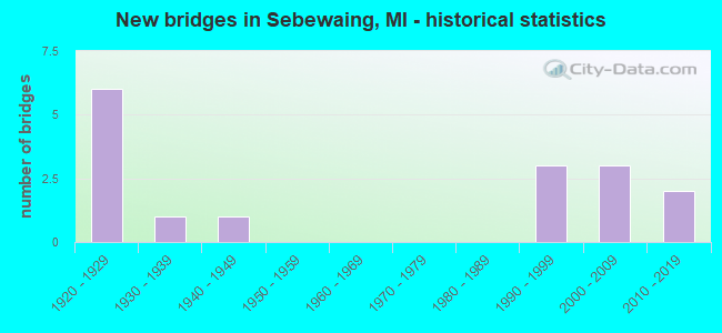
- New bridges - historical statistics
- 61920-1929
- 11930-1939
- 11940-1949
- 31990-1999
- 32000-2009
- 22010-2019

- Reconstructed bridges - Historical Statistics
- 21990-1999
- 32000-2009


- Bridge Condition - Deck
- 6.3%Very good
- 31.3%Good
- 56.3%Satisfactory
- 6.3%Fair

- Bridge Condition - Superstructure
- 31.3%Very good
- 18.8%Good
- 31.3%Satisfactory
- 18.8%Fair

- Bridge Condition - Substructure
- 12.5%Very good
- 50.0%Good
- 37.5%Satisfactory

- Bridge Condition - Channel
- 31.3%Very good
- 50.0%Good
- 12.5%Satisfactory
- 6.3%Poor
Find on map >> Show street view
Structure Number: 3444, Location: IN SEBEWAING (Lat: 43.732647, Lng: -83.446056), Route carried "on" structure: State highway 25, Year Built: 1949, Year Reconstructed: 2007, Status: Open, Structure Length: 4.39m (14.40ft), Average Daily Traffic: 5,123 (year 2007), Truck Traffic: 3%, Average Future Daily Traffic: 6,518 (year 2018), Design Load: HS 20+Mod, Features Intersected: SEBEWAING RIVER
Minimum Vertical Clearance: 30.48m (100.00ft), Kilometerpoint: 7.622, Lanes on structure: 2, Base Highway Network: Yes (Inventory Route: 103, Subroute: 8), Owner: State Highway Agency, Approaching Roadway Width: 6.1m (20.0ft), Material/Design: Steel continuous, Design/Construction: Stringer/Multi-beam, Number Of Spans In Main Unit: 3, Length of Maximum Span: 17.4m (57.1ft), Curb or Sidewalk Widths: Left: 1.9m (6.2ft), Right: 1.9m (6.2ft), Curb-To-Curb Width: 11.6m (38.1ft), Out-to-Out Width: 16.2m (53.1ft)
Condition: Deck: Satisfactory, Superstructure: Fair, Substructure: Satisfactory, Channel: Satisfactory, Operating Rating: 83.6 metric tons, Method Used To Determine Operating Rating: Load Factor (LF) rating reported by rating factor (RF) method using MS18 loading, Inventory Rating: 50.2 metric tons, Method Used To Determine Inventory Rating: Load Factor (LF) rating reported by rating factor (RF) method using MS18 loading, Structural Evaluation: Somewhat better than minimum adequacy, Deck Geometry: Somewhat better than minimum adequacy, Waterway Adequacy: Equal to present desirable criteria, Approach Roadway Alignment: Equal to present desirable criteria, Length Of Structure Improvement: 4.30m (14.11ft), Designated Inspection Frequency: Every 24 months, Underwater Inspection Frequency: Every 60 months, Inspection Date: June 2021, Underwater Inspection Date: July 2020, Bridge Improvement Cost: $223,000, Roadway Improvement Cost: $11,000, Total Project Cost: $127,000, Deck Structure Type: Concrete Cast-file-Place, Wearing Surface/Protective System: Wearing Surface: Monolithic Concrete, Deck Protection: Epoxy Coated Reinforcing
Find on map >> Show street view
Structure Number: 3514, Location: SEC. 8-17 SEBEWAING TWP. (Lat: 43.726214, Lng: -83.436903), Route carried "on" structure: County highway 3218, Year Built: 1990, Status: Open, Structure Length: 1.52m (4.99ft), Average Daily Traffic: 2,260 (year 2009), Truck Traffic: 7%, Average Future Daily Traffic: 4,080 (year 2029), Design Load: HS 20, Features Intersected: SEBEWAING RIVER, Facility Carried by Structure: SEBEWAING ROAD
Minimum Vertical Clearance: 30.48m (100.00ft), Kilometerpoint: 2.396, Lanes on structure: 2, Owner: County Highway Agency, Approaching Roadway Width: 10.4m (34.1ft), Material/Design: Prestressed concrete, Design/Construction: Tee Beam, Number Of Spans In Main Unit: 1, Length of Maximum Span: 14.6m (47.9ft), Curb-To-Curb Width: 12.0m (39.4ft), Out-to-Out Width: 12.9m (42.3ft)
Condition: Deck: Satisfactory, Superstructure: Satisfactory, Substructure: Satisfactory, Channel: Good, Inventory Rating: 62.8 metric tons, Method Used To Determine Inventory Rating: Load Factor (LF), Structural Evaluation: Equal to present minimum criteria, Deck Geometry: Somewhat better than minimum adequacy, Waterway Adequacy: Equal to present desirable criteria, Approach Roadway Alignment: Better than present minimum criteria, Designated Inspection Frequency: Every 24 months, Inspection Date: September 2021, Deck Structure Type: Concrete Precast Panels, Wearing Surface/Protective System: Wearing Surface: Bituminous, Membrane: Preformed Fabric
Find on map >> Show street view
Structure Number: 3515, Location: SEC. 11-14 SEBEWAING TWP. (Lat: 43.726997, Lng: -83.392550), Route carried "on" structure: County highway 3218, Year Built: 1990, Status: Open, Structure Length: 2.35m (7.71ft), Average Daily Traffic: 2,100 (year 2009), Truck Traffic: 9%, Average Future Daily Traffic: 3,790 (year 2029), Design Load: HS 20, Features Intersected: COLUMBIA DRAIN, Facility Carried by Structure: SEBEWAING ROAD
Minimum Vertical Clearance: 30.48m (100.00ft), Kilometerpoint: 5.969, Lanes on structure: 2, Owner: County Highway Agency, Approaching Roadway Width: 9.8m (32.2ft), Skew: 3 degrees, Material/Design: Prestressed concrete, Design/Construction: Tee Beam, Number Of Spans In Main Unit: 2, Length of Maximum Span: 11.2m (36.7ft), Curb-To-Curb Width: 12.1m (39.7ft), Out-to-Out Width: 13.0m (42.7ft)
Condition: Deck: Satisfactory, Superstructure: Satisfactory, Substructure: Satisfactory, Channel: Very good, Operating Rating: 70.8 metric tons, Method Used To Determine Operating Rating: Load Factor (LF), Inventory Rating: 42.4 metric tons, Method Used To Determine Inventory Rating: Load Factor (LF), Structural Evaluation: Equal to present minimum criteria, Deck Geometry: Somewhat better than minimum adequacy, Waterway Adequacy: Equal to present desirable criteria, Approach Roadway Alignment: Equal to present desirable criteria, Designated Inspection Frequency: Every 24 months, Inspection Date: October 2021, Deck Structure Type: Concrete Precast Panels, Wearing Surface/Protective System: Wearing Surface: Bituminous, Membrane: Preformed Fabric
Find on map >> Show street view
Structure Number: 3648, Location: SEC 21-28 SEBEWAING TWP (Lat: 43.697344, Lng: -83.425700), Route carried "on" structure: ServiceCounty highway , Year Built: 1925, Status: Posted for load, Structure Length: 0.70m (2.30ft), Average Daily Traffic: 315 (year 2009), Truck Traffic: 3%, Average Future Daily Traffic: 570 (year 2029), Design Load: H 15, Features Intersected: KEMP I/C DRAIN, Facility Carried by Structure: MCALPIN ROAD
Minimum Vertical Clearance: 30.48m (100.00ft), Kilometerpoint: 3.731, Lanes on structure: 2, Owner: County Highway Agency, Approaching Roadway Width: 9.1m (29.9ft), Skew: 4 degrees, Material/Design: Steel, Design/Construction: Stringer/Multi-beam, Number Of Spans In Main Unit: 1, Length of Maximum Span: 6.5m (21.3ft), Curb-To-Curb Width: 7.3m (24.0ft), Out-to-Out Width: 7.3m (24.0ft)
Condition: Deck: Satisfactory, Superstructure: Good, Substructure: Good, Channel: Poor, Operating Rating: 36.0 metric tons, Method Used To Determine Operating Rating: Load Factor (LF) rating reported by rating factor (RF) method using MS18 loading, Inventory Rating: 21.7 metric tons, Method Used To Determine Inventory Rating: Load Factor (LF) rating reported by rating factor (RF) method using MS18 loading, Structural Evaluation: Equal to present minimum criteria, Deck Geometry: Somewhat better than minimum adequacy, Waterway Adequacy: Equal to present desirable criteria, Approach Roadway Alignment: Equal to present minimum criteria, Bridge Posting: Required (Relationship of Operating Rating to Maximum Legal Load: 20.0 - 29.9% below), Designated Inspection Frequency: Every 24 months, Inspection Date: September 2021, Deck Structure Type: Concrete Cast-file-Place, Wearing Surface/Protective System: Wearing Surface: Monolithic Concrete
Find on map >> Show street view
Structure Number: 3649, Location: SEC 22-27 SEBEWAING TWP (Lat: 43.697903, Lng: -83.396492), Route carried "on" structure: ServiceCounty highway , Year Built: 1995, Status: Open, Structure Length: 2.80m (9.19ft), Average Daily Traffic: 75 (year 2009), Truck Traffic: 1%, Average Future Daily Traffic: 135 (year 2029), Design Load: HS 20, Features Intersected: STATE DRAIN, Facility Carried by Structure: MCALPIN ROAD
Minimum Vertical Clearance: 30.48m (100.00ft), Kilometerpoint: 6.087, Lanes on structure: 2, Owner: County Highway Agency, Approaching Roadway Width: 9.1m (29.9ft), Skew: 3 degrees, Material/Design: Prestressed concrete, Design/Construction: Box Beam or Girders - Multiple, Number Of Spans In Main Unit: 1, Length of Maximum Span: 27.6m (90.6ft), Curb-To-Curb Width: 9.4m (30.8ft), Out-to-Out Width: 10.5m (34.4ft)
Condition: Deck: Fair, Superstructure: Fair, Substructure: Good, Channel: Good, Operating Rating: 53.5 metric tons, Method Used To Determine Operating Rating: Load and Resistance Factor Rating (LRFR) rating reported by rating factor(RF) method using HL-93 loadings, Inventory Rating: 41.1 metric tons, Method Used To Determine Inventory Rating: Load and Resistance Factor Rating (LRFR) rating reported by rating factor(RF) method using HL-93 loadings, Structural Evaluation: Somewhat better than minimum adequacy, Deck Geometry: Better than present minimum criteria, Waterway Adequacy: Equal to present desirable criteria, Approach Roadway Alignment: Equal to present desirable criteria, Designated Inspection Frequency: Every 24 months, Inspection Date: September 2021, Deck Structure Type: Concrete Precast Panels, Wearing Surface/Protective System: Wearing Surface: Bituminous, Membrane: Built-up
Find on map >> Show street view
Structure Number: 365, Location: SEC. 16-21 SEBEWAING TWP. (Lat: 43.711836, Lng: -83.427667), Route carried "on" structure: ServiceCounty highway , Year Built: 1925, Year Reconstructed: 2014, Status: Open, Structure Length: 1.30m (4.27ft), Average Daily Traffic: 134 (year 2013), Truck Traffic: 3%, Average Future Daily Traffic: 242 (year 2033), Design Load: Greater than HL93, Features Intersected: STATE DRAIN, Facility Carried by Structure: RESCUE ROAD
Minimum Vertical Clearance: 30.48m (100.00ft), Kilometerpoint: 0.621, Lanes on structure: 2, Owner: County Highway Agency, Approaching Roadway Width: 9.8m (32.2ft), Material/Design: Prestressed concrete, Design/Construction: Box Beam or Girders - Multiple, Number Of Spans In Main Unit: 1, Length of Maximum Span: 12.6m (41.3ft), Curb-To-Curb Width: 8.7m (28.5ft), Out-to-Out Width: 9.5m (31.2ft)
Condition: Deck: Good, Superstructure: Very good, Substructure: Good, Channel: Good, Operating Rating: 68.0 metric tons, Method Used To Determine Operating Rating: Load and Resistance Factor Rating (LRFR) rating reported by rating factor(RF) method using HL-93 loadings, Inventory Rating: 52.5 metric tons, Method Used To Determine Inventory Rating: Load and Resistance Factor Rating (LRFR) rating reported by rating factor(RF) method using HL-93 loadings, Structural Evaluation: Better than present minimum criteria, Deck Geometry: Equal to present minimum criteria, Waterway Adequacy: Equal to present desirable criteria, Approach Roadway Alignment: Better than present minimum criteria, Designated Inspection Frequency: Every 24 months, Inspection Date: September 2021, Deck Structure Type: Concrete Precast Panels, Wearing Surface/Protective System: Wearing Surface: Bituminous, Membrane: Preformed Fabric
Find on map >> Show street view
Structure Number: 3653, Location: SEC 16-17 SEBEWAING TWP (Lat: 43.724706, Lng: -83.435778), Route carried "on" structure: ServiceCounty highway , Year Built: 2014, Status: Open, Structure Length: 2.44m (8.01ft), Average Daily Traffic: 185 (year 2013), Truck Traffic: 3%, Average Future Daily Traffic: 330 (year 2033), Design Load: Greater than HL93, Features Intersected: STATE I/C DRAIN, Facility Carried by Structure: CARO ROAD
Minimum Vertical Clearance: 30.48m (100.00ft), Kilometerpoint: 6.438, Lanes on structure: 2, Owner: County Highway Agency, Approaching Roadway Width: 9.8m (32.2ft), Material/Design: Prestressed concrete, Design/Construction: Stringer/Multi-beam, Number Of Spans In Main Unit: 1, Length of Maximum Span: 23.6m (77.4ft), Curb-To-Curb Width: 9.8m (32.2ft), Out-to-Out Width: 10.8m (35.4ft)
Condition: Deck: Good, Superstructure: Very good, Substructure: Very good, Channel: Very good, Operating Rating: 79.4 metric tons, Method Used To Determine Operating Rating: Load and Resistance Factor Rating (LRFR) rating reported by rating factor(RF) method using HL-93 loadings, Inventory Rating: 60.6 metric tons, Method Used To Determine Inventory Rating: Load and Resistance Factor Rating (LRFR) rating reported by rating factor(RF) method using HL-93 loadings, Structural Evaluation: Equal to present desirable criteria, Deck Geometry: Better than present minimum criteria, Waterway Adequacy: Equal to present desirable criteria, Approach Roadway Alignment: Equal to present desirable criteria, Designated Inspection Frequency: Every 24 months, Inspection Date: September 2021, Deck Structure Type: Concrete Cast-file-Place, Wearing Surface/Protective System: Wearing Surface: Epoxy Overlay, Deck Protection: Epoxy Coated Reinforcing
Find on map >> Show street view
Structure Number: 3654, Location: SEC. 21-22 SEBEWAING TWP. (Lat: 43.706169, Lng: -83.415242), Route carried "on" structure: ServiceCounty highway , Year Built: 1925, Year Reconstructed: 2002, Status: Open, Structure Length: 1.37m (4.49ft), Average Daily Traffic: 410 (year 2009), Truck Traffic: 3%, Average Future Daily Traffic: 740 (year 2029), Design Load: HS 20, Features Intersected: STATE DRAIN, Facility Carried by Structure: LANGE ROAD
Minimum Vertical Clearance: 30.48m (100.00ft), Kilometerpoint: 4.178, Lanes on structure: 2, Owner: County Highway Agency, Approaching Roadway Width: 8.5m (27.9ft), Skew: 4 degrees, Material/Design: Prestressed concrete, Design/Construction: Box Beam or Girders - Multiple, Number Of Spans In Main Unit: 1, Length of Maximum Span: 13.2m (43.3ft), Curb-To-Curb Width: 8.5m (27.9ft), Out-to-Out Width: 8.5m (27.9ft)
Condition: Deck: Good, Superstructure: Satisfactory, Substructure: Good, Channel: Very good, Operating Rating: 80.7 metric tons, Method Used To Determine Operating Rating: Load Factor (LF) rating reported by rating factor (RF) method using MS18 loading, Inventory Rating: 48.3 metric tons, Method Used To Determine Inventory Rating: Load Factor (LF) rating reported by rating factor (RF) method using MS18 loading, Structural Evaluation: Equal to present minimum criteria, Deck Geometry: Somewhat better than minimum adequacy, Waterway Adequacy: Equal to present desirable criteria, Approach Roadway Alignment: Equal to present desirable criteria, Designated Inspection Frequency: Every 24 months, Inspection Date: September 2021, Deck Structure Type: Concrete Precast Panels, Wearing Surface/Protective System: Wearing Surface: Bituminous, Membrane: Built-up
Find on map >> Show street view
Structure Number: 3655, Location: SEC 9-10 SEBEWAING TWP (Lat: 43.736217, Lng: -83.416208), Route carried "on" structure: ServiceCounty highway , Year Built: 1927, Year Reconstructed: 2001, Status: Open, Structure Length: 0.93m (3.05ft), Average Daily Traffic: 440 (year 2009), Truck Traffic: 3%, Average Future Daily Traffic: 795 (year 2029), Design Load: HS 20, Features Intersected: COLUMBIA DRAIN, Facility Carried by Structure: LANGE ROAD
Minimum Vertical Clearance: 30.48m (100.00ft), Kilometerpoint: 7.518, Lanes on structure: 2, Owner: County Highway Agency, Approaching Roadway Width: 9.1m (29.9ft), Material/Design: Prestressed concrete, Design/Construction: Tee Beam, Number Of Spans In Main Unit: 1, Length of Maximum Span: 8.8m (28.9ft), Curb-To-Curb Width: 8.5m (27.9ft), Out-to-Out Width: 8.5m (27.9ft)
Condition: Deck: Very good, Superstructure: Very good, Substructure: Good, Channel: Good, Operating Rating: 36.6 metric tons, Method Used To Determine Operating Rating: Load and Resistance Factor Rating (LRFR) rating reported by rating factor(RF) method using HL-93 loadings, Inventory Rating: 28.2 metric tons, Method Used To Determine Inventory Rating: Load and Resistance Factor Rating (LRFR) rating reported by rating factor(RF) method using HL-93 loadings, Structural Evaluation: Better than present minimum criteria, Deck Geometry: Somewhat better than minimum adequacy, Waterway Adequacy: Equal to present desirable criteria, Approach Roadway Alignment: Equal to present desirable criteria, Designated Inspection Frequency: Every 24 months, Inspection Date: October 2021, Deck Structure Type: Concrete Precast Panels, Wearing Surface/Protective System: Wearing Surface: Bituminous, Membrane: Built-up
Find on map >> Show street view
Structure Number: 3656, Location: SEC. 26-27 SEBEWAING TWP. (Lat: 43.696539, Lng: -83.394878), Route carried "on" structure: ServiceCounty highway , Year Built: 2007, Status: Open, Structure Length: 3.41m (11.19ft), Average Daily Traffic: 110 (year 2009), Average Future Daily Traffic: 200 (year 2029), Design Load: HS 20, Features Intersected: STATE DRAIN, Facility Carried by Structure: GETTEL ROAD
Minimum Vertical Clearance: 30.48m (100.00ft), Kilometerpoint: 3.066, Lanes on structure: 2, Owner: County Highway Agency, Approaching Roadway Width: 9.8m (32.2ft), Skew: 4 degrees, Material/Design: Prestressed concrete, Design/Construction: Box Beam or Girders - Multiple, Number Of Spans In Main Unit: 1, Length of Maximum Span: 33.7m (110.6ft), Curb-To-Curb Width: 9.2m (30.2ft), Out-to-Out Width: 10.0m (32.8ft)
Condition: Deck: Satisfactory, Superstructure: Fair, Substructure: Good, Channel: Good, Operating Rating: 60.3 metric tons, Method Used To Determine Operating Rating: Load and Resistance Factor Rating (LRFR) rating reported by rating factor(RF) method using HL-93 loadings, Inventory Rating: 46.7 metric tons, Method Used To Determine Inventory Rating: Load and Resistance Factor Rating (LRFR) rating reported by rating factor(RF) method using HL-93 loadings, Structural Evaluation: Somewhat better than minimum adequacy, Deck Geometry: Equal to present minimum criteria, Waterway Adequacy: Equal to present desirable criteria, Approach Roadway Alignment: Equal to present minimum criteria, Designated Inspection Frequency: Every 24 months, Inspection Date: September 2021, Deck Structure Type: Concrete Precast Panels, Wearing Surface/Protective System: Wearing Surface: Bituminous, Membrane: Built-up
Find on map >> Show street view
Structure Number: 3658, Location: SEC. 14 SEBEWAING TWP. (Lat: 43.723481, Lng: -83.385728), Route carried "on" structure: ServiceCounty highway , Year Built: 1927, Status: Posted for load, Structure Length: 0.91m (2.99ft), Average Daily Traffic: 25 (year 2009), Truck Traffic: 3%, Average Future Daily Traffic: 45 (year 2029), Design Load: H 15, Features Intersected: COLUMBIA DRAIN, Facility Carried by Structure: GAETH ROAD
Minimum Vertical Clearance: 30.48m (100.00ft), Kilometerpoint: 1.209, Lanes on structure: 2, Owner: County Highway Agency, Approaching Roadway Width: 6.1m (20.0ft), Material/Design: Steel, Design/Construction: Stringer/Multi-beam, Number Of Spans In Main Unit: 1, Length of Maximum Span: 8.5m (27.9ft), Curb-To-Curb Width: 6.1m (20.0ft), Out-to-Out Width: 6.2m (20.3ft)
Condition: Deck: Satisfactory, Superstructure: Good, Substructure: Satisfactory, Channel: Very good, Operating Rating: 26.6 metric tons, Method Used To Determine Operating Rating: Load Factor (LF) rating reported by rating factor (RF) method using MS18 loading, Inventory Rating: 15.9 metric tons, Method Used To Determine Inventory Rating: Load Factor (LF) rating reported by rating factor (RF) method using MS18 loading, Structural Evaluation: Meets minimum limits, Deck Geometry: Somewhat better than minimum adequacy, Waterway Adequacy: Equal to present desirable criteria, Approach Roadway Alignment: Better than present minimum criteria, Bridge Posting: Required (Relationship of Operating Rating to Maximum Legal Load: > 39.9% below), Length Of Structure Improvement: 1.10m (3.61ft), Designated Inspection Frequency: Every 24 months, Inspection Date: October 2021, Bridge Improvement Cost: $245,000, Roadway Improvement Cost: $20,000, Total Project Cost: $290,000, Deck Structure Type: Concrete Cast-file-Place, Wearing Surface/Protective System: Wearing Surface: Monolithic Concrete
Find on map >> Show street view
Structure Number: 3659, Location: SEC. 13-14 SEBEWAING TWP. (Lat: 43.718197, Lng: -83.375608), Route carried "on" structure: ServiceCounty highway , Year Built: 1927, Year Reconstructed: 2005, Status: Open, Structure Length: 0.88m (2.89ft), Average Daily Traffic: 25 (year 2009), Truck Traffic: 3%, Average Future Daily Traffic: 45 (year 2029), Design Load: HS 20, Features Intersected: COLUMBIA DRAIN, Facility Carried by Structure: VOLZ ROAD
Minimum Vertical Clearance: 30.48m (100.00ft), Kilometerpoint: 5.432, Lanes on structure: 2, Owner: County Highway Agency, Approaching Roadway Width: 7.9m (25.9ft), Material/Design: Prestressed concrete, Design/Construction: Box Beam or Girders - Multiple, Number Of Spans In Main Unit: 1, Length of Maximum Span: 8.5m (27.9ft), Curb-To-Curb Width: 8.5m (27.9ft), Out-to-Out Width: 8.6m (28.2ft)
Condition: Deck: Good, Superstructure: Good, Substructure: Satisfactory, Channel: Satisfactory, Operating Rating: 94.3 metric tons, Method Used To Determine Operating Rating: Load Factor (LF) rating reported by rating factor (RF) method using MS18 loading, Inventory Rating: 56.4 metric tons, Method Used To Determine Inventory Rating: Load Factor (LF) rating reported by rating factor (RF) method using MS18 loading, Structural Evaluation: Equal to present minimum criteria, Deck Geometry: Better than present minimum criteria, Waterway Adequacy: Equal to present desirable criteria, Approach Roadway Alignment: Equal to present minimum criteria, Designated Inspection Frequency: Every 24 months, Inspection Date: October 2021, Deck Structure Type: Concrete Cast-file-Place, Wearing Surface/Protective System: Wearing Surface: Monolithic Concrete, Deck Protection: Epoxy Coated Reinforcing
Find on map >> Show street view
Structure Number: 3681, Location: 0.4 MI E OF M-25 (Lat: 43.730061, Lng: -83.438078), Route carried "on" structure: ServiceCounty highway , Year Built: 2013, Status: Open, Structure Length: 4.69m (15.39ft), Average Daily Traffic: 5,590 (year 2011), Truck Traffic: 5%, Average Future Daily Traffic: 880 (year 2031), Design Load: Greater than HL93, Features Intersected: SEBEWAING RIVER, Facility Carried by Structure: ANTON STREET
Minimum Vertical Clearance: 30.48m (100.00ft), Kilometerpoint: 0.113, Lanes on structure: 2, Owner: City or Municipal Highway Agency, Approaching Roadway Width: 8.8m (28.9ft), Skew: 3 degrees, Material/Design: Prestressed concrete, Design/Construction: Box Beam or Girders - Multiple, Number Of Spans In Main Unit: 3, Length of Maximum Span: 25.0m (82.0ft), Curb-To-Curb Width: 8.7m (28.5ft), Out-to-Out Width: 9.6m (31.5ft)
Condition: Deck: Satisfactory, Superstructure: Very good, Substructure: Very good, Channel: Good, Operating Rating: 53.8 metric tons, Method Used To Determine Operating Rating: Load and Resistance Factor Rating (LRFR) rating reported by rating factor(RF) method using HL-93 loadings, Inventory Rating: 41.5 metric tons, Method Used To Determine Inventory Rating: Load and Resistance Factor Rating (LRFR) rating reported by rating factor(RF) method using HL-93 loadings, Structural Evaluation: Equal to present desirable criteria, Waterway Adequacy: Equal to present desirable criteria, Approach Roadway Alignment: Equal to present desirable criteria, Designated Inspection Frequency: Every 24 months, Inspection Date: September 2021, Deck Structure Type: Concrete Cast-file-Place, Wearing Surface/Protective System: Wearing Surface: Monolithic Concrete, Deck Protection: Epoxy Coated Reinforcing
Find on map >> Show street view
Structure Number: 3682, Location: 0.25 MI W OF M-25 (Lat: 43.733411, Lng: -83.450997), Route carried "on" structure: ServiceCounty highway , Year Built: 2003, Status: Open, Structure Length: 2.68m (8.79ft), Average Daily Traffic: 4,900 (year 2009), Truck Traffic: 8%, Average Future Daily Traffic: 8,820 (year 2020), Design Load: HS 20, Features Intersected: SEBEWAING RIVER, Facility Carried by Structure: CENTER STREET
Minimum Vertical Clearance: 30.48m (100.00ft), Kilometerpoint: 3.626, Lanes on structure: 2, Owner: City or Municipal Highway Agency, Approaching Roadway Width: 9.1m (29.9ft), Material/Design: Concrete, Design/Construction: Box Beam or Girders - Multiple, Number Of Spans In Main Unit: 1, Length of Maximum Span: 25.8m (84.6ft), Curb or Sidewalk Widths: Left: 2.1m (6.9ft), Right: 2.1m (6.9ft), Curb-To-Curb Width: 9.1m (29.9ft), Out-to-Out Width: 14.3m (46.9ft)
Condition: Deck: Satisfactory, Superstructure: Satisfactory, Substructure: Good, Channel: Very good, Operating Rating: 93.4 metric tons, Method Used To Determine Operating Rating: Load Factor (LF), Inventory Rating: 46.0 metric tons, Method Used To Determine Inventory Rating: Load Factor (LF), Structural Evaluation: Equal to present minimum criteria, Deck Geometry: Meets minimum limits, Waterway Adequacy: Better than present minimum criteria, Approach Roadway Alignment: Equal to present desirable criteria, Designated Inspection Frequency: Every 24 months, Inspection Date: September 2021, Deck Structure Type: Concrete Cast-file-Place, Wearing Surface/Protective System: Wearing Surface: Monolithic Concrete, Deck Protection: Epoxy Coated Reinforcing
Find on map >> Show street view
Structure Number: 12602, Location: SEC. 2-3 SEBEWAING TWP. (Lat: 43.746808, Lng: -83.396567), Route carried "on" structure: County highway , Year Built: 1930, Status: Open, Structure Length: 0.67m (2.20ft), Average Daily Traffic: 100 (year 2009), Truck Traffic: 40%, Average Future Daily Traffic: 180 (year 2029), Design Load: H 15, Features Intersected: GETTEL DRAIN, Facility Carried by Structure: GETTEL ROAD
Minimum Vertical Clearance: 30.48m (100.00ft), Kilometerpoint: 8.651, Lanes on structure: 2, Owner: County Highway Agency, Approaching Roadway Width: 9.1m (29.9ft), Skew: 4 degrees, Material/Design: Concrete, Design/Construction: Slab, Number Of Spans In Main Unit: 1, Length of Maximum Span: 6.6m (21.7ft), Curb-To-Curb Width: 8.8m (28.9ft), Out-to-Out Width: 9.0m (29.5ft)
Condition: Deck: Satisfactory, Superstructure: Satisfactory, Substructure: Satisfactory, Channel: Good, Operating Rating: 51.5 metric tons, Method Used To Determine Operating Rating: Load Factor (LF), Inventory Rating: 30.8 metric tons, Method Used To Determine Inventory Rating: Load Factor (LF), Structural Evaluation: Equal to present minimum criteria, Deck Geometry: Better than present minimum criteria, Waterway Adequacy: Better than present minimum criteria, Approach Roadway Alignment: Equal to present desirable criteria, Designated Inspection Frequency: Every 24 months, Inspection Date: October 2021, Deck Structure Type: Concrete Cast-file-Place, Wearing Surface/Protective System: Wearing Surface: Bituminous
Find on map >> Show street view
Structure Number: 13307, Location: SEBEWAING VILLAGE PARK (Lat: 43.737267, Lng: -83.458372), Route carried "on" structure: ServiceCity street , Year Built: 2005, Status: Open, Structure Length: 2.37m (7.78ft), Average Daily Traffic: 75 (year 2005), Average Future Daily Traffic: 135 (year 2025), Design Load: HS 20, Features Intersected: SEWBEWAING RIVER, I/C DR, Facility Carried by Structure: UNION STREET
Minimum Vertical Clearance: 30.48m (100.00ft), Kilometerpoint: 0.452, Lanes on structure: 2, Owner: City or Municipal Highway Agency, Approaching Roadway Width: 9.8m (32.2ft), Material/Design: Steel, Design/Construction: Truss - Thru, Number Of Spans In Main Unit: 1, Length of Maximum Span: 21.8m (71.5ft), Curb-To-Curb Width: 9.8m (32.2ft), Out-to-Out Width: 11.6m (38.1ft)
Condition: Deck: Good, Superstructure: Very good, Substructure: Good, Channel: Good, Operating Rating: 65.4 metric tons, Method Used To Determine Operating Rating: Load Factor (LF), Inventory Rating: 43.6 metric tons, Method Used To Determine Inventory Rating: Load Factor (LF), Structural Evaluation: Better than present minimum criteria, Deck Geometry: Equal to present desirable criteria, Waterway Adequacy: Better than present minimum criteria, Approach Roadway Alignment: Equal to present minimum criteria, Designated Inspection Frequency: Every 24 months, Critical Feature Inspection Frequency: Every 24 months, Inspection Date: September 2021, Critical Feature Inspection Date: September 2021, Deck Structure Type: Steel plate, Wearing Surface/Protective System: Wearing Surface: Bituminous, Deck Protection: Galvanized Reinforcing