Bridge Statistics for Sedley, Virginia (VA)
Condition, Traffic, Stress, Structural Evaluation, Project Costs
- National Bridge Inventory (NBI) Statistics
- 15Number of bridges
- 49ft / 14.6mTotal length
- $782,000Total costs
- 4,418Total average daily traffic
- 91Total average daily truck traffic
- 5,148Total future (year 2040) average daily traffic
- National Bridge Inventory (NBI) Registered Bridges for Sedley
- No street view available for this location
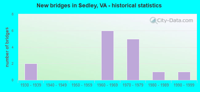
- New bridges - historical statistics
- 21930-1939
- 61960-1969
- 51970-1979
- 11980-1989
- 11990-1999

- Reconstructed bridges - Historical Statistics
- 32000-2009
- 32010-2019

- Bridge Condition - Deck
- 37.5%Very good
- 62.5%Good

- Bridge Condition - Superstructure
- 37.5%Very good
- 62.5%Good

- Bridge Condition - Substructure
- 75.0%Good
- 25.0%Satisfactory

- Bridge Condition - Channel
- 6.7%Very good
- 60.0%Good
- 20.0%Satisfactory
- 13.3%Fair

- Bridge Condition - Culverts
- 28.6%Satisfactory
- 71.4%Fair
Find on map >> Show street view
Structure Number: 17764, Location: 0.55 Mi to Int Rte 638 (Lat: 36.803300, Lng: -76.954858), Route carried "on" structure: County highway 603, Year Built: 1966, Year Reconstructed: 2005, Status: Open, Structure Length: 1.01m (3.31ft), Average Daily Traffic: 631 (year 2020), Truck Traffic: 4%, Average Future Daily Traffic: 883 (year 2040), Design Load: HS 20, Features Intersected: Whitfield Mill, Facility Carried by Structure: Unity Road
Minimum Vertical Clearance: 30+ m (98+ ft), Kilometerpoint: 6.629, Lanes on structure: 2, Owner: State Highway Agency, Approaching Roadway Width: 6.1m (20.0ft), Material/Design: Steel, Design/Construction: Stringer/Multi-beam, Number Of Spans In Main Unit: 1, Length of Maximum Span: 10.1m (33.1ft), Curb-To-Curb Width: 7.6m (24.9ft), Out-to-Out Width: 8.0m (26.2ft)
Condition: Deck: Good, Superstructure: Good, Substructure: Satisfactory, Channel: Good, Operating Rating: 54.9 metric tons, Method Used To Determine Operating Rating: Load Factor (LF), Inventory Rating: 32.8 metric tons, Method Used To Determine Inventory Rating: Load Factor (LF), Structural Evaluation: Equal to present minimum criteria, Deck Geometry: Meets minimum limits, Waterway Adequacy: Better than present minimum criteria, Approach Roadway Alignment: Better than present minimum criteria, Length Of Structure Improvement: 1.68m (5.51ft), Designated Inspection Frequency: Every 24 months, Inspection Date: October 2021, Bridge Improvement Cost: $113,000, Roadway Improvement Cost: $17,000, Total Project Cost: $158,000 ( Estimate for 2018), Deck Structure Type: Wood or Timber, Wearing Surface/Protective System: Wearing Surface: Gravel
Find on map >> Show street view
Structure Number: 17775, Location: 0.75 Mi to Int Rte 643 (Lat: 36.722928, Lng: -76.994950), Route carried "on" structure: County highway 611, Year Built: 1966, Year Reconstructed: 2008, Status: Open, Structure Length: 1.07m (3.51ft), Average Daily Traffic: 316 (year 2018), Average Future Daily Traffic: 351 (year 2040), Design Load: HS 20+Mod, Features Intersected: Nottoway Swamp, Facility Carried by Structure: Storys Station Rd
Minimum Vertical Clearance: 30+ m (98+ ft), Kilometerpoint: 7.401, Lanes on structure: 2, Owner: State Highway Agency, Approaching Roadway Width: 7.3m (24.0ft), Material/Design: Steel, Design/Construction: Stringer/Multi-beam, Number Of Spans In Main Unit: 1, Length of Maximum Span: 10.7m (35.1ft), Curb-To-Curb Width: 7.3m (24.0ft), Out-to-Out Width: 8.0m (26.2ft)
Condition: Deck: Good, Superstructure: Good, Substructure: Satisfactory, Channel: Good, Operating Rating: 38.1 metric tons, Method Used To Determine Operating Rating: Load and Resistance Factor (LRFR), Inventory Rating: 29.4 metric tons, Method Used To Determine Inventory Rating: Load and Resistance Factor (LRFR), Structural Evaluation: Equal to present minimum criteria, Deck Geometry: Somewhat better than minimum adequacy, Waterway Adequacy: Equal to present minimum criteria, Approach Roadway Alignment: Better than present minimum criteria, Designated Inspection Frequency: Every 24 months, Inspection Date: April 2020, Deck Structure Type: Wood or Timber, Wearing Surface/Protective System: Wearing Surface: Bituminous
Find on map >> Show street view
Structure Number: 17805, Location: 0.50 Mi. to Int. Rte. 630 (Lat: 36.799078, Lng: -76.916511), Route carried "on" structure: County highway 626, Year Built: 1999, Status: Open, Structure Length: 0.61m (2.00ft), Average Daily Traffic: 64 (year 2018), Average Future Daily Traffic: 71 (year 2040), Design Load: HS 20+Mod, Features Intersected: Wade Branch, Facility Carried by Structure: Womble Mill Road
Minimum Vertical Clearance: 30+ m (98+ ft), Kilometerpoint: 17.248, Lanes on structure: 2, Owner: State Highway Agency, Approaching Roadway Width: 5.5m (18.0ft), Material/Design: Steel, Design/Construction: Culvert, Number Of Spans In Main Unit: 3, Length of Maximum Span: 1.8m (5.9ft)
Condition: Channel: Fair, Culverts: Fair, Operating Rating: 54.4 metric tons, Method Used To Determine Operating Rating: Load Factor (LF), Inventory Rating: 32.7 metric tons, Method Used To Determine Inventory Rating: Load Factor (LF), Structural Evaluation: Somewhat better than minimum adequacy, Waterway Adequacy: Better than present minimum criteria, Approach Roadway Alignment: Better than present minimum criteria, Designated Inspection Frequency: Every 24 months, Inspection Date: July 2021
Find on map >> Show street view
Structure Number: 17806, Location: 0.35 MI. TO INT. RTE. 630 (Lat: 36.797219, Lng: -76.919253), Route carried "on" structure: County highway 626, Year Built: 1968, Status: Open, Structure Length: 0.67m (2.20ft), Average Daily Traffic: 64 (year 2018), Average Future Daily Traffic: 71 (year 2040), Design Load: HS 20+Mod, Features Intersected: Wade Mill Pond, Facility Carried by Structure: Womble Mill Road
Minimum Vertical Clearance: 30+ m (98+ ft), Kilometerpoint: 17.490, Lanes on structure: 2, Owner: State Highway Agency, Approaching Roadway Width: 5.2m (17.1ft), Skew: 1 degrees, Material/Design: Steel, Design/Construction: Culvert, Number Of Spans In Main Unit: 3, Length of Maximum Span: 1.8m (5.9ft)
Condition: Channel: Satisfactory, Culverts: Fair, Operating Rating: 44.5 metric tons, Method Used To Determine Operating Rating: Load Factor (LF), Inventory Rating: 32.7 metric tons, Method Used To Determine Inventory Rating: Load Factor (LF), Structural Evaluation: Somewhat better than minimum adequacy, Waterway Adequacy: Better than present minimum criteria, Approach Roadway Alignment: Better than present minimum criteria, Designated Inspection Frequency: Every 24 months, Inspection Date: July 2021
Find on map >> Show street view
Structure Number: 17809, Location: 0.30 MI TO ROUTE 603 (Lat: 36.799544, Lng: -76.947953), Route carried "on" structure: County highway 631, Year Built: 1962, Year Reconstructed: 2017, Status: Open, Structure Length: 2.10m (6.89ft), Average Daily Traffic: 203 (year 2018), Average Future Daily Traffic: 225 (year 2040), Design Load: HS 20+Mod, Features Intersected: Black Creek, Facility Carried by Structure: Mission Church Rd
Minimum Vertical Clearance: 30+ m (98+ ft), Kilometerpoint: 2.553, Lanes on structure: 2, Owner: State Highway Agency, Approaching Roadway Width: 5.9m (19.4ft), Material/Design: Steel, Design/Construction: Stringer/Multi-beam, Number Of Spans In Main Unit: 2, Length of Maximum Span: 10.7m (35.1ft), Curb-To-Curb Width: 7.3m (24.0ft), Out-to-Out Width: 8.4m (27.6ft)
Condition: Deck: Good, Superstructure: Good, Substructure: Good, Channel: Good, Operating Rating: 71.0 metric tons, Method Used To Determine Operating Rating: Load and Resistance Factor (LRFR), Inventory Rating: 54.8 metric tons, Method Used To Determine Inventory Rating: Load and Resistance Factor (LRFR), Structural Evaluation: Better than present minimum criteria, Deck Geometry: Somewhat better than minimum adequacy, Waterway Adequacy: Better than present minimum criteria, Approach Roadway Alignment: Better than present minimum criteria, Length Of Structure Improvement: 2.10m (6.89ft), Designated Inspection Frequency: Every 24 months, Inspection Date: March 2021, Bridge Improvement Cost: $209,000, Roadway Improvement Cost: $21,000, Total Project Cost: $313,000 ( Estimate for 2018), Deck Structure Type: Wood or Timber, Wearing Surface/Protective System: Wearing Surface: Bituminous
Find on map >> Show street view
Structure Number: 1781, Location: 0.11 mi to Int. Rte. 643 (Lat: 36.773981, Lng: -77.004417), Route carried "on" structure: County highway 632, Year Built: 1974, Status: Open, Structure Length: 0.66m (2.17ft), Average Daily Traffic: 580 (year 2018), Average Future Daily Traffic: 598 (year 2040), Design Load: HS 20, Features Intersected: Branch Darden Millpond, Facility Carried by Structure: Sycamore Ave
Minimum Vertical Clearance: 30+ m (98+ ft), Kilometerpoint: 0.177, Lanes on structure: 2, Owner: State Highway Agency, Approaching Roadway Width: 5.3m (17.4ft), Material/Design: Steel, Design/Construction: Culvert, Number Of Spans In Main Unit: 3, Length of Maximum Span: 1.8m (5.9ft)
Condition: Channel: Good, Culverts: Fair, Operating Rating: 44.5 metric tons, Method Used To Determine Operating Rating: Load Factor (LF), Inventory Rating: 32.7 metric tons, Method Used To Determine Inventory Rating: Load Factor (LF), Structural Evaluation: Somewhat better than minimum adequacy, Waterway Adequacy: Better than present minimum criteria, Approach Roadway Alignment: Equal to present desirable criteria, Designated Inspection Frequency: Every 24 months, Inspection Date: November 2021
Find on map >> Show street view
Structure Number: 1782, Location: 0.70 MI TO INT. RTE.603 (Lat: 36.793525, Lng: -76.963581), Route carried "on" structure: County highway 638, Year Built: 1961, Year Reconstructed: 2018, Status: Open, Structure Length: 1.00m (3.28ft), Average Daily Traffic: 226 (year 2018), Average Future Daily Traffic: 251 (year 2040), Design Load: HL 93, Features Intersected: Black Creek, Facility Carried by Structure: Drake Road
Minimum Vertical Clearance: 30+ m (98+ ft), Kilometerpoint: 7.440, Lanes on structure: 2, Owner: State Highway Agency, Approaching Roadway Width: 4.6m (15.1ft), Material/Design: Steel, Design/Construction: Stringer/Multi-beam, Number Of Spans In Main Unit: 1, Length of Maximum Span: 10.0m (32.8ft), Curb-To-Curb Width: 5.7m (18.7ft), Out-to-Out Width: 6.4m (21.0ft)
Condition: Deck: Very good, Superstructure: Very good, Substructure: Good, Channel: Good, Operating Rating: 76.2 metric tons, Method Used To Determine Operating Rating: Load and Resistance Factor (LRFR), Inventory Rating: 59.0 metric tons, Method Used To Determine Inventory Rating: Load and Resistance Factor (LRFR), Structural Evaluation: Better than present minimum criteria, Deck Geometry: High priority of corrective action, Waterway Adequacy: Better than present minimum criteria, Approach Roadway Alignment: Better than present minimum criteria, Length Of Structure Improvement: 1.65m (5.41ft), Designated Inspection Frequency: Every 24 months, Inspection Date: April 2020, Deck Structure Type: Wood or Timber
Find on map >> Show street view
Structure Number: 17821, Location: 0.10 TO 637 1.10 TO 635 (Lat: 36.755656, Lng: -76.946119), Route carried "on" structure: County highway 640, Year Built: 1932, Year Reconstructed: 2008, Status: Open, Structure Length: 1.04m (3.41ft), Average Daily Traffic: 67 (year 2018), Average Future Daily Traffic: 74 (year 2040), Features Intersected: Cypress Swamp, Facility Carried by Structure: Berea Church Road
Minimum Vertical Clearance: 30+ m (98+ ft), Kilometerpoint: 3.379, Lanes on structure: 2, Owner: State Highway Agency, Approaching Roadway Width: 5.0m (16.4ft), Material/Design: Steel, Design/Construction: Stringer/Multi-beam, Number Of Spans In Main Unit: 1, Length of Maximum Span: 10.4m (34.1ft), Curb-To-Curb Width: 7.4m (24.3ft), Out-to-Out Width: 7.9m (25.9ft)
Condition: Deck: Very good, Superstructure: Very good, Substructure: Good, Channel: Good, Operating Rating: 75.1 metric tons, Method Used To Determine Operating Rating: Load Factor (LF), Inventory Rating: 45.0 metric tons, Method Used To Determine Inventory Rating: Load Factor (LF), Structural Evaluation: Better than present minimum criteria, Deck Geometry: Equal to present minimum criteria, Waterway Adequacy: Equal to present minimum criteria, Approach Roadway Alignment: Equal to present minimum criteria, Length Of Structure Improvement: 1.68m (5.51ft), Designated Inspection Frequency: Every 24 months, Inspection Date: November 2021, Bridge Improvement Cost: $129,000, Roadway Improvement Cost: $20,000, Total Project Cost: $194,000, Deck Structure Type: Wood or Timber, Wearing Surface/Protective System: Wearing Surface: Gravel
Find on map >> Show street view
Structure Number: 17822, Location: 0.90 MI. TO INT. RTE. 603 (Lat: 36.794211, Lng: -76.978142), Route carried "on" structure: County highway 641, Year Built: 1989, Status: Open, Structure Length: 1.43m (4.69ft), Average Daily Traffic: 652 (year 2020), Truck Traffic: 4%, Average Future Daily Traffic: 699 (year 2040), Design Load: HS 20+Mod, Features Intersected: Johnsons Mill, Facility Carried by Structure: Johnsons Mill Road
Minimum Vertical Clearance: 30+ m (98+ ft), Kilometerpoint: 12.039, Lanes on structure: 2, Owner: State Highway Agency, Approaching Roadway Width: 8.8m (28.9ft), Material/Design: Prestressed concrete, Design/Construction: Slab, Number Of Spans In Main Unit: 1, Length of Maximum Span: 13.7m (44.9ft), Curb-To-Curb Width: 9.0m (29.5ft), Out-to-Out Width: 9.8m (32.2ft)
Condition: Deck: Good, Superstructure: Good, Substructure: Good, Channel: Very good, Operating Rating: 71.6 metric tons, Method Used To Determine Operating Rating: Load and Resistance Factor (LRFR), Inventory Rating: 51.1 metric tons, Method Used To Determine Inventory Rating: Load and Resistance Factor (LRFR), Structural Evaluation: Better than present minimum criteria, Deck Geometry: Somewhat better than minimum adequacy, Waterway Adequacy: Equal to present desirable criteria, Approach Roadway Alignment: Equal to present desirable criteria, Designated Inspection Frequency: Every 24 months, Inspection Date: May 2021, Deck Structure Type: Concrete Cast-file-Place, Wearing Surface/Protective System: Wearing Surface: Gravel
Find on map >> Show street view
Structure Number: 17823, Location: 0.05 Mi to Int. Rte. 646 (Lat: 36.770436, Lng: -76.976889), Route carried "on" structure: County highway 642, Year Built: 1978, Status: Open, Structure Length: 0.61m (2.00ft), Average Daily Traffic: 155 (year 2018), Average Future Daily Traffic: 172 (year 2040), Design Load: HS 20, Features Intersected: Branch, Facility Carried by Structure: Cobb Road
Minimum Vertical Clearance: 30+ m (98+ ft), Kilometerpoint: 1.046, Lanes on structure: 2, Owner: State Highway Agency, Approaching Roadway Width: 5.2m (17.1ft), Material/Design: Steel, Design/Construction: Culvert, Number Of Spans In Main Unit: 3, Length of Maximum Span: 1.8m (5.9ft)
Condition: Channel: Fair, Culverts: Fair, Operating Rating: 44.5 metric tons, Method Used To Determine Operating Rating: Load Factor (LF), Inventory Rating: 32.7 metric tons, Method Used To Determine Inventory Rating: Load Factor (LF), Structural Evaluation: Somewhat better than minimum adequacy, Waterway Adequacy: Equal to present desirable criteria, Approach Roadway Alignment: Equal to present desirable criteria, Designated Inspection Frequency: Every 24 months, Inspection Date: November 2021
Find on map >> Show street view
Structure Number: 17824, Location: 0.20 MI. TO INT. RTE. 632 (Lat: 36.770494, Lng: -77.005364), Route carried "on" structure: County highway 643, Year Built: 1974, Status: Open, Structure Length: 0.61m (2.00ft), Average Daily Traffic: 124 (year 2018), Average Future Daily Traffic: 179 (year 2040), Design Load: HS 20, Features Intersected: Branch Darden Millpond, Facility Carried by Structure: Darden Scout Road
Minimum Vertical Clearance: 30+ m (98+ ft), Kilometerpoint: 8.362, Lanes on structure: 2, Owner: State Highway Agency, Approaching Roadway Width: 5.5m (18.0ft), Skew: 1 degrees, Material/Design: Steel, Design/Construction: Culvert, Number Of Spans In Main Unit: 3, Length of Maximum Span: 1.8m (5.9ft)
Condition: Channel: Good, Culverts: Satisfactory, Operating Rating: 44.5 metric tons, Method Used To Determine Operating Rating: Load Factor (LF), Inventory Rating: 32.7 metric tons, Method Used To Determine Inventory Rating: Load Factor (LF), Structural Evaluation: Equal to present minimum criteria, Waterway Adequacy: Equal to present desirable criteria, Approach Roadway Alignment: Better than present minimum criteria, Designated Inspection Frequency: Every 24 months, Inspection Date: January 2021
Find on map >> Show street view
Structure Number: 17825, Location: 0.10 TO 646 / 1.30 TO 632 (Lat: 36.755264, Lng: -77.003425), Route carried "on" structure: County highway 643, Year Built: 1975, Status: Open, Structure Length: 0.61m (2.00ft), Average Daily Traffic: 124 (year 2018), Average Future Daily Traffic: 179 (year 2040), Design Load: HS 20, Features Intersected: Branch Darden Millpond, Facility Carried by Structure: Darden Scout Road
Minimum Vertical Clearance: 30+ m (98+ ft), Kilometerpoint: 6.592, Lanes on structure: 2, Owner: State Highway Agency, Approaching Roadway Width: 7.9m (25.9ft), Material/Design: Steel, Design/Construction: Culvert, Number Of Spans In Main Unit: 3, Length of Maximum Span: 1.8m (5.9ft)
Condition: Channel: Satisfactory, Culverts: Fair, Operating Rating: 44.5 metric tons, Method Used To Determine Operating Rating: Load Factor (LF), Inventory Rating: 32.7 metric tons, Method Used To Determine Inventory Rating: Load Factor (LF), Structural Evaluation: Somewhat better than minimum adequacy, Waterway Adequacy: Better than present minimum criteria, Approach Roadway Alignment: Equal to present desirable criteria, Designated Inspection Frequency: Every 24 months, Inspection Date: October 2021
Find on map >> Show street view
Structure Number: 17826, Location: 0.95 MI. TO INT. RTE. 616 (Lat: 36.790133, Lng: -77.046842), Route carried "on" structure: County highway 645, Year Built: 1932, Year Reconstructed: 2010, Status: Open, Structure Length: 0.71m (2.33ft), Average Daily Traffic: 184 (year 2018), Average Future Daily Traffic: 265 (year 2040), Design Load: HS 20+Mod, Features Intersected: Indian Branch, Facility Carried by Structure: Trinity Church Rd
Minimum Vertical Clearance: 30+ m (98+ ft), Kilometerpoint: 2.011, Lanes on structure: 2, Owner: State Highway Agency, Approaching Roadway Width: 4.9m (16.1ft), Material/Design: Steel, Design/Construction: Stringer/Multi-beam, Number Of Spans In Main Unit: 1, Length of Maximum Span: 7.1m (23.3ft), Curb-To-Curb Width: 6.0m (19.7ft), Out-to-Out Width: 8.0m (26.2ft)
Condition: Deck: Very good, Superstructure: Very good, Substructure: Good, Channel: Good, Operating Rating: 68.9 metric tons, Method Used To Determine Operating Rating: Load and Resistance Factor (LRFR), Inventory Rating: 53.5 metric tons, Method Used To Determine Inventory Rating: Load and Resistance Factor (LRFR), Structural Evaluation: Better than present minimum criteria, Deck Geometry: High priority of corrective action, Waterway Adequacy: Better than present minimum criteria, Approach Roadway Alignment: Equal to present desirable criteria, Length Of Structure Improvement: 0.91m (2.99ft), Designated Inspection Frequency: Every 24 months, Inspection Date: August 2020, Bridge Improvement Cost: $45,000, Roadway Improvement Cost: $12,000, Total Project Cost: $69,000, Deck Structure Type: Wood or Timber, Wearing Surface/Protective System: Wearing Surface: Gravel
Find on map >> Show street view
Structure Number: 17827, Location: 3.32ECL COURT/1.00 TO 643 (Lat: 36.752511, Lng: -77.019908), Route carried "on" structure: County highway 646, Year Built: 1972, Status: Open, Structure Length: 0.61m (2.00ft), Average Daily Traffic: 514 (year 2020), Truck Traffic: 4%, Average Future Daily Traffic: 565 (year 2040), Design Load: HS 20, Features Intersected: Branch Nottoway River, Facility Carried by Structure: Governor Darden Rd
Minimum Vertical Clearance: 30+ m (98+ ft), Kilometerpoint: 6.114, Lanes on structure: 2, Owner: State Highway Agency, Approaching Roadway Width: 6.7m (22.0ft), Material/Design: Steel, Design/Construction: Culvert, Number Of Spans In Main Unit: 3, Length of Maximum Span: 1.8m (5.9ft)
Condition: Channel: Good, Culverts: Satisfactory, Operating Rating: 44.5 metric tons, Method Used To Determine Operating Rating: Load Factor (LF), Inventory Rating: 32.7 metric tons, Method Used To Determine Inventory Rating: Load Factor (LF), Structural Evaluation: Equal to present minimum criteria, Waterway Adequacy: Equal to present desirable criteria, Approach Roadway Alignment: Better than present minimum criteria, Length Of Structure Improvement: 0.61m (2.00ft), Designated Inspection Frequency: Every 24 months, Underwater Inspection Frequency: Every 24 months, Inspection Date: July 2020, Underwater Inspection Date: July 2020, Bridge Improvement Cost: $28,000, Roadway Improvement Cost: $10,000, Total Project Cost: $48,000 ( Estimate for 2018)
Find on map >> Show street view
Structure Number: 17828, Location: 4.27 TO T1505/0.O5 TO 643 (Lat: 36.754372, Lng: -77.004283), Route carried "on" structure: County highway 646, Year Built: 1968, Status: Open, Structure Length: 1.86m (6.10ft), Average Daily Traffic: 514 (year 2020), Truck Traffic: 4%, Average Future Daily Traffic: 565 (year 2040), Design Load: HS 20, Features Intersected: Darden Mill Pond, Facility Carried by Structure: Governor Darden Rd
Minimum Vertical Clearance: 30+ m (98+ ft), Kilometerpoint: 7.321, Lanes on structure: 2, Owner: State Highway Agency, Approaching Roadway Width: 5.4m (17.7ft), Material/Design: Steel, Design/Construction: Stringer/Multi-beam, Number Of Spans In Main Unit: 2, Length of Maximum Span: 9.4m (30.8ft), Curb-To-Curb Width: 7.3m (24.0ft), Out-to-Out Width: 8.0m (26.2ft)
Condition: Deck: Good, Superstructure: Good, Substructure: Good, Channel: Satisfactory, Operating Rating: 55.3 metric tons, Method Used To Determine Operating Rating: Load and Resistance Factor (LRFR), Inventory Rating: 42.6 metric tons, Method Used To Determine Inventory Rating: Load and Resistance Factor (LRFR), Structural Evaluation: Better than present minimum criteria, Deck Geometry: Meets minimum limits, Waterway Adequacy: Better than present minimum criteria, Approach Roadway Alignment: Better than present minimum criteria, Designated Inspection Frequency: Every 24 months, Inspection Date: November 2020, Deck Structure Type: Wood or Timber, Wearing Surface/Protective System: Wearing Surface: Gravel