Bridge Statistics for Selah, Washington (WA)
Condition, Traffic, Stress, Structural Evaluation, Project Costs
- National Bridge Inventory (NBI) Statistics
- 28Number of bridges
- 397ft / 121mTotal length
- $68,962,000Total costs
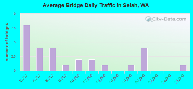
- 216,388Total average daily traffic
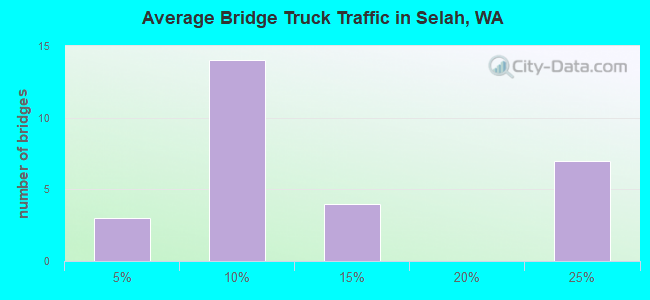
- 27,602Total average daily truck traffic
- National Bridge Inventory (NBI) Registered Bridges for Selah
- No street view available for this location
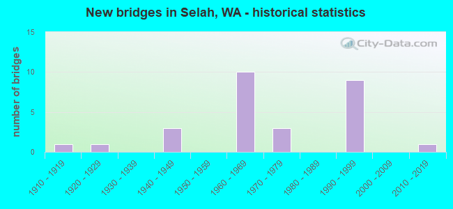
- New bridges - historical statistics
- 11910-1919
- 11920-1929
- 31940-1949
- 101960-1969
- 31970-1979
- 91990-1999
- 12010-2019
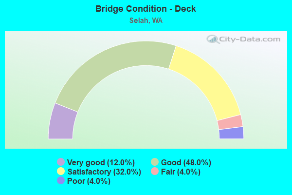
- Bridge Condition - Deck
- 12.0%Very good
- 48.0%Good
- 32.0%Satisfactory
- 4.0%Fair
- 4.0%Poor
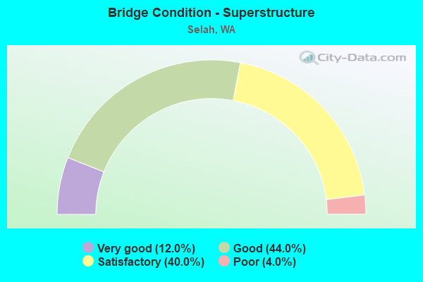
- Bridge Condition - Superstructure
- 12.0%Very good
- 44.0%Good
- 40.0%Satisfactory
- 4.0%Poor
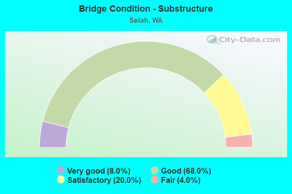
- Bridge Condition - Substructure
- 8.0%Very good
- 68.0%Good
- 20.0%Satisfactory
- 4.0%Fair
Find on map >> Show street view
Structure Number: 652A, Location: 2.4 N JCT I-82 (Lat: 46.707889, Lng: -120.468250), Route carried "on" structure: State highway 821, Year Built: 1924, Status: Open, Structure Length: 1.37m (4.49ft), Average Daily Traffic: 1,533 (year 2019), Truck Traffic: 10%, Average Future Daily Traffic: 2,011 (year 2039), Design Load: H 20, Features Intersected: SELAH CREEK
Minimum Vertical Clearance: 30+ m (98+ ft), Kilometerpoint: 3.782, Lanes on structure: 2, Owner: State Highway Agency, Approaching Roadway Width: 11.6m (38.1ft), Material/Design: Concrete continuous, Design/Construction: Slab, Number Of Spans In Main Unit: 2, Length of Maximum Span: 6.1m (20.0ft), Curb-To-Curb Width: 7.3m (24.0ft), Out-to-Out Width: 8.1m (26.6ft)
Condition: Deck: Good, Superstructure: Satisfactory, Substructure: Good, Channel: Very good, Operating Rating: 51.7 metric tons, Method Used To Determine Operating Rating: Load Factor (LF), Inventory Rating: 30.8 metric tons, Method Used To Determine Inventory Rating: Load Factor (LF), Structural Evaluation: Equal to present minimum criteria, Deck Geometry: Meets minimum limits, Waterway Adequacy: Equal to present minimum criteria, Approach Roadway Alignment: Equal to present desirable criteria, Length Of Structure Improvement: 1.37m (4.49ft), Designated Inspection Frequency: Every 24 months, Inspection Date: September 2021, Bridge Improvement Cost: $360,000, Roadway Improvement Cost: $72,000, Total Project Cost: $720,000 ( Estimate for 2014), Deck Structure Type: Concrete Cast-file-Place, Wearing Surface/Protective System: Wearing Surface: Bituminous
Find on map >> Show street view
Structure Number: 3209A, Location: 0.1 N JCT I-82 (Lat: 46.635997, Lng: -120.524783), Route carried "on" structure: State highway 823, Year Built: 1947, Status: Open, Structure Length: 10.21m (33.50ft), Average Daily Traffic: 3,499 (year 2019), Truck Traffic: 4%, Average Future Daily Traffic: 4,590 (year 2039), Design Load: HS 20, Features Intersected: YAKIMA RIVER
Minimum Vertical Clearance: 30+ m (98+ ft), Kilometerpoint: 0.145, Lanes on structure: 2, Base Highway Network: Yes, Owner: State Highway Agency, Approaching Roadway Width: 12.2m (40.0ft), Material/Design: Concrete continuous, Design/Construction: Tee Beam, Number Of Spans In Main Unit: 5, Length of Maximum Span: 26.5m (86.9ft), Curb or Sidewalk Widths: Left: 1.1m (3.6ft), Right: 1.2m (3.9ft), Curb-To-Curb Width: 8.5m (27.9ft), Out-to-Out Width: 11.8m (38.7ft)
Condition: Deck: Satisfactory, Superstructure: Satisfactory, Substructure: Satisfactory, Channel: Very good, Operating Rating: 59.9 metric tons, Method Used To Determine Operating Rating: Load Factor (LF), Inventory Rating: 36.3 metric tons, Method Used To Determine Inventory Rating: Load Factor (LF), Structural Evaluation: Equal to present minimum criteria, Deck Geometry: Meets minimum limits, Waterway Adequacy: Equal to present desirable criteria, Approach Roadway Alignment: Equal to present desirable criteria, Length Of Structure Improvement: 10.21m (33.50ft), Designated Inspection Frequency: Every 24 months, Inspection Date: August 2021, Bridge Improvement Cost: $2,814,000, Roadway Improvement Cost: $563,000, Total Project Cost: $5,628,000 ( Estimate for 2014), Deck Structure Type: Concrete Cast-file-Place, Wearing Surface/Protective System: Wearing Surface: Bituminous
Find on map >> Show street view
Structure Number: 3209B, Location: 0.2 N JCT I-82 (Lat: 46.637142, Lng: -120.527358), Route carried "on" structure: State highway 823, Year Built: 1947, Status: Open, Structure Length: 5.43m (17.81ft), Average Daily Traffic: 18,242 (year 2019), Truck Traffic: 5%, Average Future Daily Traffic: 23,933 (year 2039), Design Load: HS 20, Features Intersected: SLOUGH & CNTY RD
Minimum Vertical Clearance: 30+ m (98+ ft), Kilometerpoint: 0.386, Lanes on structure: 2, Lanes under structure: 2, Base Highway Network: Yes, Owner: State Highway Agency, Approaching Roadway Width: 8.5m (27.9ft), Material/Design: Concrete, Design/Construction: Tee Beam, Number Of Spans In Main Unit: 4, Length of Maximum Span: 17.1m (56.1ft), Curb or Sidewalk Widths: Left: 0.8m (2.6ft), Right: 0.7m (2.3ft), Curb-To-Curb Width: 8.5m (27.9ft), Out-to-Out Width: 11.0m (36.1ft)
Condition: Deck: Good, Superstructure: Good, Substructure: Satisfactory, Channel: Very good, Operating Rating: 64.4 metric tons, Method Used To Determine Operating Rating: Load Factor (LF), Inventory Rating: 38.1 metric tons, Method Used To Determine Inventory Rating: Load Factor (LF), Structural Evaluation: Equal to present minimum criteria, Deck Geometry: High priority of corrective action, Underclear: High priority of corrective action, Waterway Adequacy: Equal to present desirable criteria, Approach Roadway Alignment: Equal to present desirable criteria, Length Of Structure Improvement: 5.43m (17.81ft), Designated Inspection Frequency: Every 24 months, Inspection Date: October 2021, Bridge Improvement Cost: $1,068,000, Roadway Improvement Cost: $214,000, Total Project Cost: $2,136,000 ( Estimate for 2014), Deck Structure Type: Concrete Cast-file-Place, Wearing Surface/Protective System: Wearing Surface: Bituminous
Find on map >> Show street view
Structure Number: 3346A, Location: 0.4 N JCT I-82 (Lat: 46.638944, Lng: -120.528667), Route carried "on" structure: State highway 823, Year Built: 1947, Status: Open, Structure Length: 10.52m (34.51ft), Average Daily Traffic: 18,242 (year 2019), Truck Traffic: 5%, Average Future Daily Traffic: 23,933 (year 2039), Design Load: HS 20, Features Intersected: BN RR
Minimum Vertical Clearance: 30+ m (98+ ft), Kilometerpoint: 0.612, Lanes on structure: 2, Base Highway Network: Yes, Owner: State Highway Agency, Approaching Roadway Width: 12.2m (40.0ft), Material/Design: Concrete, Design/Construction: Tee Beam, Number Of Spans In Main Unit: 6, Length of Maximum Span: 24.4m (80.1ft), Curb or Sidewalk Widths: Left: 0.9m (3.0ft), Right: 0.8m (2.6ft), Curb-To-Curb Width: 8.7m (28.5ft), Out-to-Out Width: 11.0m (36.1ft)
Condition: Deck: Fair, Superstructure: Satisfactory, Substructure: Fair, Operating Rating: 37.6 metric tons, Method Used To Determine Operating Rating: Load and Resistance Factor Rating (LRFR) rating reported by rating factor(RF) method using HL-93 loadings, Inventory Rating: 29.2 metric tons, Method Used To Determine Inventory Rating: Load and Resistance Factor Rating (LRFR) rating reported by rating factor(RF) method using HL-93 loadings, Structural Evaluation: Somewhat better than minimum adequacy, Deck Geometry: High priority of corrective action, Underclear: Somewhat better than minimum adequacy, Approach Roadway Alignment: Equal to present desirable criteria, Length Of Structure Improvement: 10.52m (34.51ft), Designated Inspection Frequency: Every 24 months, Inspection Date: July 2021, Bridge Improvement Cost: $2,898,000, Roadway Improvement Cost: $580,000, Total Project Cost: $5,796,000 ( Estimate for 2014), Deck Structure Type: Concrete Cast-file-Place, Wearing Surface/Protective System: Wearing Surface: Bituminous
Find on map >> Show street view
Structure Number: 8089A, Location: 2.4 E JCT SR 821 (Lat: 46.647444, Lng: -120.503194), Route carried "on" structure: Interstate 82, Year Built: 1967, Status: Open, Structure Length: 3.17m (10.40ft), Average Daily Traffic: 11,545 (year 2019), Truck Traffic: 21%, Average Future Daily Traffic: 15,147 (year 2039), Design Load: HS 20+Mod, Features Intersected: EAST SELAH
Minimum Vertical Clearance: 30+ m (98+ ft), Kilometerpoint: 46.703, Lanes on structure: 2, Lanes under structure: 2, Base Highway Network: Yes, Owner: State Highway Agency, Approaching Roadway Width: 12.2m (40.0ft), Material/Design: Concrete continuous, Design/Construction: Slab, Number Of Spans In Main Unit: 3, Length of Maximum Span: 13.4m (44.0ft), Curb or Sidewalk Widths: Left: 0.2m (0.7ft), Right: 0.2m (0.7ft), Curb-To-Curb Width: 11.1m (36.4ft), Out-to-Out Width: 12.2m (40.0ft)
Condition: Deck: Satisfactory, Superstructure: Satisfactory, Substructure: Good, Operating Rating: 69.8 metric tons, Method Used To Determine Operating Rating: Load Factor (LF), Inventory Rating: 41.7 metric tons, Method Used To Determine Inventory Rating: Load Factor (LF), Structural Evaluation: Equal to present minimum criteria, Deck Geometry: Somewhat better than minimum adequacy, Underclear: Meets minimum limits, Approach Roadway Alignment: Equal to present desirable criteria, Length Of Structure Improvement: 3.17m (10.40ft), Designated Inspection Frequency: Every 24 months, Inspection Date: April 2021, Bridge Improvement Cost: $874,000, Roadway Improvement Cost: $175,000, Total Project Cost: $1,747,000 ( Estimate for 2014), Deck Structure Type: Concrete Cast-file-Place, Wearing Surface/Protective System: Wearing Surface: Latex Concrete
Find on map >> Show street view
Structure Number: 8089B, Location: 2.4 E JCT SR 821 (Lat: 46.647222, Lng: -120.503028), Route carried "on" structure: Interstate 82, Year Built: 1967, Status: Open, Structure Length: 3.17m (10.40ft), Average Daily Traffic: 11,545 (year 2019), Truck Traffic: 21%, Average Future Daily Traffic: 15,147 (year 2039), Design Load: HS 20+Mod, Features Intersected: EAST SELAH
Minimum Vertical Clearance: 30+ m (98+ ft), Kilometerpoint: 46.703, Lanes on structure: 2, Lanes under structure: 2, Base Highway Network: Yes, Owner: State Highway Agency, Approaching Roadway Width: 12.2m (40.0ft), Material/Design: Concrete continuous, Design/Construction: Slab, Number Of Spans In Main Unit: 3, Length of Maximum Span: 13.4m (44.0ft), Curb or Sidewalk Widths: Left: 0.2m (0.7ft), Right: 0.2m (0.7ft), Curb-To-Curb Width: 11.1m (36.4ft), Out-to-Out Width: 12.2m (40.0ft)
Condition: Deck: Satisfactory, Superstructure: Satisfactory, Substructure: Good, Operating Rating: 69.8 metric tons, Method Used To Determine Operating Rating: Load Factor (LF), Inventory Rating: 41.7 metric tons, Method Used To Determine Inventory Rating: Load Factor (LF), Structural Evaluation: Equal to present minimum criteria, Deck Geometry: Somewhat better than minimum adequacy, Underclear: Meets minimum limits, Approach Roadway Alignment: Equal to present desirable criteria, Length Of Structure Improvement: 3.17m (10.40ft), Designated Inspection Frequency: Every 24 months, Inspection Date: April 2021, Bridge Improvement Cost: $874,000, Roadway Improvement Cost: $175,000, Total Project Cost: $1,747,000 ( Estimate for 2014), Deck Structure Type: Concrete Cast-file-Place, Wearing Surface/Protective System: Wearing Surface: Monolithic Concrete
Find on map >> Show street view
Structure Number: 8560A, Location: JCT I-82 (Lat: 46.677544, Lng: -120.480722), Route carried "on" structure: State highway 821, Year Built: 1969, Status: Open, Structure Length: 8.53m (27.99ft), Average Daily Traffic: 4,966 (year 2019), Truck Traffic: 12%, Average Future Daily Traffic: 6,515 (year 2039), Design Load: HS 20+Mod, Features Intersected: I-82
Minimum Vertical Clearance: 30+ m (98+ ft), Kilometerpoint: 0.001, Lanes on structure: 3, Lanes under structure: 4, Owner: State Highway Agency, Approaching Roadway Width: 15.2m (49.9ft), Material/Design: Prestressed concrete continuous, Design/Construction: Stringer/Multi-beam, Number Of Spans In Main Unit: 4, Length of Maximum Span: 28.7m (94.2ft), Curb or Sidewalk Widths: Left: 0.2m (0.7ft), Right: 0.2m (0.7ft), Curb-To-Curb Width: 14.2m (46.6ft), Out-to-Out Width: 15.2m (49.9ft)
Condition: Deck: Good, Superstructure: Good, Substructure: Good, Operating Rating: 76.2 metric tons, Method Used To Determine Operating Rating: Load Factor (LF), Inventory Rating: 44.4 metric tons, Method Used To Determine Inventory Rating: Load Factor (LF), Structural Evaluation: Better than present minimum criteria, Deck Geometry: Somewhat better than minimum adequacy, Underclear: Equal to present minimum criteria, Approach Roadway Alignment: Equal to present desirable criteria, Length Of Structure Improvement: 8.53m (27.99ft), Designated Inspection Frequency: Every 24 months, Inspection Date: July 2021, Bridge Improvement Cost: $2,912,000, Roadway Improvement Cost: $582,000, Total Project Cost: $5,824,000 ( Estimate for 2014), Deck Structure Type: Concrete Cast-file-Place, Wearing Surface/Protective System: Wearing Surface: Bituminous, Membrane: Preformed Fabric
Find on map >> Show street view
Structure Number: 8560B, Location: 0.4 N JCT I-82 (Lat: 46.682222, Lng: -120.480500), Route carried "on" structure: State highway 821, Year Built: 1969, Status: Open, Structure Length: 2.93m (9.61ft), Average Daily Traffic: 3,785 (year 2019), Truck Traffic: 11%, Average Future Daily Traffic: 4,965 (year 2039), Design Load: HS 20+Mod, Features Intersected: ROZA CANAL
Minimum Vertical Clearance: 30+ m (98+ ft), Kilometerpoint: 0.692, Lanes on structure: 2, Owner: State Highway Agency, Approaching Roadway Width: 11.6m (38.1ft), Material/Design: Prestressed concrete, Design/Construction: Stringer/Multi-beam, Number Of Spans In Main Unit: 1, Length of Maximum Span: 27.7m (90.9ft), Curb-To-Curb Width: 11.6m (38.1ft), Out-to-Out Width: 12.6m (41.3ft)
Condition: Deck: Good, Superstructure: Good, Substructure: Good, Channel: Very good, Operating Rating: 62.6 metric tons, Method Used To Determine Operating Rating: Load Factor (LF), Inventory Rating: 37.2 metric tons, Method Used To Determine Inventory Rating: Load Factor (LF), Structural Evaluation: Better than present minimum criteria, Deck Geometry: Somewhat better than minimum adequacy, Waterway Adequacy: Equal to present desirable criteria, Approach Roadway Alignment: Equal to present desirable criteria, Length Of Structure Improvement: 2.93m (9.61ft), Designated Inspection Frequency: Every 48 months, Inspection Date: Febuary 2019, Bridge Improvement Cost: $768,000, Roadway Improvement Cost: $154,000, Total Project Cost: $1,536,000 ( Estimate for 2014), Deck Structure Type: Concrete Cast-file-Place, Wearing Surface/Protective System: Wearing Surface: Bituminous
Find on map >> Show street view
Structure Number: 8561B, Location: 6.3 E KITTITAS CO (Lat: 46.680917, Lng: -120.476028), Route carried "on" structure: Interstate 82, Year Built: 1969, Status: Open, Structure Length: 3.20m (10.50ft), Average Daily Traffic: 9,800 (year 2019), Truck Traffic: 21%, Average Future Daily Traffic: 12,857 (year 2039), Design Load: HS 20+Mod, Features Intersected: ROZA CANAL
Minimum Vertical Clearance: 30+ m (98+ ft), Kilometerpoint: 42.197, Lanes on structure: 2, Base Highway Network: Yes, Owner: State Highway Agency, Approaching Roadway Width: 12.8m (42.0ft), Skew: 1 degrees, Material/Design: Prestressed concrete, Design/Construction: Stringer/Multi-beam, Number Of Spans In Main Unit: 1, Length of Maximum Span: 30.8m (101.0ft), Curb or Sidewalk Widths: Left: 0.2m (0.7ft), Right: 0.2m (0.7ft), Curb-To-Curb Width: 11.6m (38.1ft), Out-to-Out Width: 12.6m (41.3ft)
Condition: Deck: Good, Superstructure: Good, Substructure: Good, Channel: Very good, Operating Rating: 25.6 metric tons, Method Used To Determine Operating Rating: Load and Resistance Factor Rating (LRFR) rating reported by rating factor(RF) method using HL-93 loadings, Inventory Rating: 19.8 metric tons, Method Used To Determine Inventory Rating: Load and Resistance Factor Rating (LRFR) rating reported by rating factor(RF) method using HL-93 loadings, Structural Evaluation: Somewhat better than minimum adequacy, Deck Geometry: Equal to present minimum criteria, Waterway Adequacy: Equal to present desirable criteria, Approach Roadway Alignment: Equal to present desirable criteria, Length Of Structure Improvement: 3.20m (10.50ft), Designated Inspection Frequency: Every 24 months, Inspection Date: March 2020, Bridge Improvement Cost: $924,000, Roadway Improvement Cost: $185,000, Total Project Cost: $1,848,000 ( Estimate for 2014), Deck Structure Type: Concrete Cast-file-Place, Wearing Surface/Protective System: Wearing Surface: Bituminous, Membrane: Preformed Fabric
Find on map >> Show street view
Structure Number: 8561D, Location: 6.3 E KITTITAS CO (Lat: 46.680833, Lng: -120.475472), Route carried "on" structure: Interstate 82, Year Built: 1969, Status: Open, Structure Length: 3.20m (10.50ft), Average Daily Traffic: 9,800 (year 2019), Truck Traffic: 21%, Average Future Daily Traffic: 12,857 (year 2039), Design Load: HS 20+Mod, Features Intersected: ROZA CANAL
Minimum Vertical Clearance: 30+ m (98+ ft), Kilometerpoint: 42.181, Lanes on structure: 3, Base Highway Network: Yes, Owner: State Highway Agency, Approaching Roadway Width: 17.1m (56.1ft), Skew: 1 degrees, Material/Design: Prestressed concrete, Design/Construction: Stringer/Multi-beam, Number Of Spans In Main Unit: 1, Length of Maximum Span: 30.8m (101.0ft), Curb or Sidewalk Widths: Left: 0.2m (0.7ft), Right: 0.2m (0.7ft), Curb-To-Curb Width: 15.5m (50.9ft), Out-to-Out Width: 16.6m (54.5ft)
Condition: Deck: Good, Superstructure: Good, Substructure: Good, Channel: Very good, Operating Rating: 25.6 metric tons, Method Used To Determine Operating Rating: Load and Resistance Factor Rating (LRFR) rating reported by rating factor(RF) method using HL-93 loadings, Inventory Rating: 19.8 metric tons, Method Used To Determine Inventory Rating: Load and Resistance Factor Rating (LRFR) rating reported by rating factor(RF) method using HL-93 loadings, Structural Evaluation: Somewhat better than minimum adequacy, Deck Geometry: Somewhat better than minimum adequacy, Waterway Adequacy: Equal to present desirable criteria, Approach Roadway Alignment: Equal to present desirable criteria, Length Of Structure Improvement: 3.20m (10.50ft), Designated Inspection Frequency: Every 24 months, Inspection Date: March 2020, Bridge Improvement Cost: $1,218,000, Roadway Improvement Cost: $244,000, Total Project Cost: $2,436,000 ( Estimate for 2014), Deck Structure Type: Concrete Cast-file-Place, Wearing Surface/Protective System: Wearing Surface: Bituminous, Membrane: Preformed Fabric
Find on map >> Show street view
Structure Number: 15137A, Location: 0.3 E JCT SR 823 (Lat: 46.632889, Lng: -120.520306), Route carried "on" structure: County highway , Year Built: 1999, Status: Open, Structure Length: 5.97m (19.59ft), Average Daily Traffic: 586 (year 2021), Truck Traffic: 5%, Average Future Daily Traffic: 674 (year 2041), Design Load: HS 25 or greater, Features Intersected: I-82 (US 97), SR 823, Facility Carried by Structure: REST HAVEN RD
Minimum Vertical Clearance: 30+ m (98+ ft), Kilometerpoint: 0.016, Lanes on structure: 2, Lanes under structure: 7, Owner: State Highway Agency, Approaching Roadway Width: 12.2m (40.0ft), Material/Design: Prestressed concrete continuous, Design/Construction: Stringer/Multi-beam, Number Of Spans In Main Unit: 2, Length of Maximum Span: 33.2m (108.9ft), Curb-To-Curb Width: 12.2m (40.0ft), Out-to-Out Width: 12.7m (41.7ft)
Condition: Deck: Good, Superstructure: Good, Substructure: Good, Operating Rating: 67.1 metric tons, Method Used To Determine Operating Rating: Load Factor (LF), Inventory Rating: 39.9 metric tons, Method Used To Determine Inventory Rating: Load Factor (LF), Structural Evaluation: Better than present minimum criteria, Deck Geometry: Equal to present desirable criteria, Underclear: High priority of corrective action, Approach Roadway Alignment: Equal to present desirable criteria, Length Of Structure Improvement: 5.97m (19.59ft), Designated Inspection Frequency: Every 24 months, Inspection Date: April 2021, Bridge Improvement Cost: $1,646,000, Roadway Improvement Cost: $329,000, Total Project Cost: $3,293,000 ( Estimate for 2014), Deck Structure Type: Concrete Precast Panels, Wearing Surface/Protective System: Wearing Surface: Monolithic Concrete, Deck Protection: Epoxy Coated Reinforcing
Find on map >> Show street view
Structure Number: 15137F, Location: 0.4 N JCT I-82 (Lat: 46.638556, Lng: -120.528556), Route carried "on" structure: State highway 823, Year Built: 1999, Status: Open, Structure Length: 12.86m (42.19ft), Average Daily Traffic: 18,242 (year 2019), Truck Traffic: 5%, Average Future Daily Traffic: 23,933 (year 2039), Design Load: HS 25 or greater, Features Intersected: WCRR
Minimum Vertical Clearance: 30+ m (98+ ft), Kilometerpoint: 0.579, Lanes on structure: 2, Base Highway Network: Yes, Owner: State Highway Agency, Approaching Roadway Width: 10.4m (34.1ft), Skew: 3 degrees, Material/Design: Prestressed concrete continuous, Design/Construction: Stringer/Multi-beam, Number Of Spans In Main Unit: 4, Length of Maximum Span: 32.3m (106.0ft), Curb-To-Curb Width: 10.4m (34.1ft), Out-to-Out Width: 10.9m (35.8ft)
Condition: Deck: Good, Superstructure: Good, Substructure: Very good, Operating Rating: 56.2 metric tons, Method Used To Determine Operating Rating: Load Factor (LF), Inventory Rating: 33.6 metric tons, Method Used To Determine Inventory Rating: Load Factor (LF), Structural Evaluation: Better than present minimum criteria, Deck Geometry: Somewhat better than minimum adequacy, Underclear: Somewhat better than minimum adequacy, Approach Roadway Alignment: Equal to present desirable criteria, Length Of Structure Improvement: 12.86m (42.19ft), Designated Inspection Frequency: Every 24 months, Inspection Date: July 2021, Bridge Improvement Cost: $3,038,000, Roadway Improvement Cost: $608,000, Total Project Cost: $6,077,000 ( Estimate for 2014), Deck Structure Type: Concrete Cast-file-Place, Wearing Surface/Protective System: Wearing Surface: Monolithic Concrete, Deck Protection: Epoxy Coated Reinforcing
Find on map >> Show street view
Structure Number: 15137G, Location: 0.2 N JCT I-82 (Lat: 46.637150, Lng: -120.527467), Route carried "on" structure: State highway 823, Year Built: 1998, Status: Open, Structure Length: 5.70m (18.70ft), Average Daily Traffic: 18,242 (year 2019), Truck Traffic: 5%, Average Future Daily Traffic: 23,933 (year 2039), Design Load: HS 25 or greater, Features Intersected: SLOUGH, AND SR 823 RAMP
Minimum Vertical Clearance: 30+ m (98+ ft), Kilometerpoint: 0.386, Lanes on structure: 2, Lanes under structure: 2, Base Highway Network: Yes, Owner: State Highway Agency, Approaching Roadway Width: 10.4m (34.1ft), Material/Design: Prestressed concrete continuous, Design/Construction: Stringer/Multi-beam, Number Of Spans In Main Unit: 2, Length of Maximum Span: 30.8m (101.0ft), Curb or Sidewalk Widths: Left: 3.0m (9.8ft), Right: 0.0m, Curb-To-Curb Width: 10.4m (34.1ft), Out-to-Out Width: 14.6m (47.9ft)
Condition: Deck: Good, Superstructure: Good, Substructure: Good, Channel: Very good, Operating Rating: 69.8 metric tons, Method Used To Determine Operating Rating: Load Factor (LF), Inventory Rating: 41.7 metric tons, Method Used To Determine Inventory Rating: Load Factor (LF), Structural Evaluation: Better than present minimum criteria, Deck Geometry: Somewhat better than minimum adequacy, Underclear: Meets minimum limits, Waterway Adequacy: Equal to present desirable criteria, Approach Roadway Alignment: Equal to present desirable criteria, Length Of Structure Improvement: 5.70m (18.70ft), Designated Inspection Frequency: Every 24 months, Inspection Date: October 2021, Bridge Improvement Cost: $1,346,000, Roadway Improvement Cost: $269,000, Total Project Cost: $2,693,000 ( Estimate for 2014), Deck Structure Type: Concrete Cast-file-Place, Wearing Surface/Protective System: Wearing Surface: Monolithic Concrete, Deck Protection: Epoxy Coated Reinforcing
Find on map >> Show street view
Structure Number: 15137H, Location: 0.1 N JCT I-82 (Lat: 46.635856, Lng: -120.524886), Route carried "on" structure: State highway 823, Year Built: 1999, Status: Open, Structure Length: 10.21m (33.50ft), Average Daily Traffic: 3,499 (year 2019), Truck Traffic: 4%, Average Future Daily Traffic: 4,590 (year 2039), Design Load: HS 25 or greater, Features Intersected: YAKIMA RIVER
Minimum Vertical Clearance: 30+ m (98+ ft), Kilometerpoint: 0.145, Lanes on structure: 2, Base Highway Network: Yes, Owner: State Highway Agency, Approaching Roadway Width: 10.7m (35.1ft), Material/Design: Prestressed concrete continuous, Design/Construction: Stringer/Multi-beam, Number Of Spans In Main Unit: 3, Length of Maximum Span: 36.0m (118.1ft), Curb or Sidewalk Widths: Left: 3.3m (10.8ft), Right: 0.0m, Curb-To-Curb Width: 14.1m (46.3ft), Out-to-Out Width: 22.1m (72.5ft)
Condition: Deck: Satisfactory, Superstructure: Good, Substructure: Good, Channel: Very good, Operating Rating: 64.4 metric tons, Method Used To Determine Operating Rating: Load Factor (LF), Inventory Rating: 38.1 metric tons, Method Used To Determine Inventory Rating: Load Factor (LF), Structural Evaluation: Better than present minimum criteria, Deck Geometry: Superior to present desirable criteria, Waterway Adequacy: Equal to present desirable criteria, Approach Roadway Alignment: Equal to present desirable criteria, Length Of Structure Improvement: 10.21m (33.50ft), Designated Inspection Frequency: Every 24 months, Inspection Date: August 2021, Bridge Improvement Cost: $2,479,000, Roadway Improvement Cost: $496,000, Total Project Cost: $4,958,000 ( Estimate for 2014), Deck Structure Type: Concrete Cast-file-Place, Wearing Surface/Protective System: Wearing Surface: Monolithic Concrete, Deck Protection: Epoxy Coated Reinforcing
Find on map >> Show street view
Structure Number: 15137I, Location: JCT I-82 (Lat: 46.635408, Lng: -120.523258), Route carried "on" structure: State highway 823, Year Built: 1998, Status: Open, Structure Length: 3.60m (11.81ft), Average Daily Traffic: 6,998 (year 2019), Truck Traffic: 4%, Average Future Daily Traffic: 9,181 (year 2039), Design Load: HS 25 or greater, Features Intersected: I-82
Minimum Vertical Clearance: 30+ m (98+ ft), Kilometerpoint: 0.016, Lanes on structure: 3, Lanes under structure: 2, Base Highway Network: Yes, Owner: State Highway Agency, Approaching Roadway Width: 18.0m (59.1ft), Skew: 4 degrees, Material/Design: Prestressed concrete, Design/Construction: Stringer/Multi-beam, Number Of Spans In Main Unit: 1, Length of Maximum Span: 33.8m (110.9ft), Curb-To-Curb Width: 18.0m (59.1ft), Out-to-Out Width: 18.5m (60.7ft)
Condition: Deck: Good, Superstructure: Satisfactory, Substructure: Good, Operating Rating: 89.8 metric tons, Method Used To Determine Operating Rating: Load Factor (LF), Inventory Rating: 60.8 metric tons, Method Used To Determine Inventory Rating: Load Factor (LF), Structural Evaluation: Equal to present minimum criteria, Deck Geometry: Better than present minimum criteria, Underclear: Equal to present minimum criteria, Approach Roadway Alignment: Equal to present desirable criteria, Length Of Structure Improvement: 3.60m (11.81ft), Designated Inspection Frequency: Every 24 months, Inspection Date: October 2021, Bridge Improvement Cost: $1,440,000, Roadway Improvement Cost: $288,000, Total Project Cost: $2,879,000 ( Estimate for 2014), Deck Structure Type: Concrete Cast-file-Place, Wearing Surface/Protective System: Wearing Surface: Monolithic Concrete, Deck Protection: Epoxy Coated Reinforcing
Find on map >> Show street view
Structure Number: 83754, Location: 00.38 W Speyers Rd (Lat: 46.676667, Lng: -120.573333), Route carried "on" structure: County highway 12900, Year Built: 1992, Status: Open, Structure Length: 0.79m (2.59ft), Average Daily Traffic: 130 (year 2020), Truck Traffic: 5%, Average Future Daily Traffic: 120 (year 2040), Design Load: HS 20, Features Intersected: CANAL - NO.1 LATERAL, Facility Carried by Structure: RESERVOIR LOOP
Minimum Vertical Clearance: 30+ m (98+ ft), Kilometerpoint: 0.001, Lanes on structure: 2, Owner: County Highway Agency, Approaching Roadway Width: 7.9m (25.9ft), Skew: 4 degrees, Material/Design: Prestressed concrete, Design/Construction: Slab, Number Of Spans In Main Unit: 1, Length of Maximum Span: 7.6m (24.9ft), Curb-To-Curb Width: 9.6m (31.5ft), Out-to-Out Width: 9.8m (32.2ft)
Condition: Deck: Very good, Superstructure: Very good, Substructure: Good, Channel: Very good, Operating Rating: 39.5 metric tons, Method Used To Determine Operating Rating: Load and Resistance Factor Rating (LRFR) rating reported by rating factor(RF) method using HL-93 loadings, Inventory Rating: 24.3 metric tons, Method Used To Determine Inventory Rating: Load and Resistance Factor Rating (LRFR) rating reported by rating factor(RF) method using HL-93 loadings, Structural Evaluation: Equal to present minimum criteria, Deck Geometry: Equal to present minimum criteria, Waterway Adequacy: Equal to present desirable criteria, Approach Roadway Alignment: Equal to present desirable criteria, Length Of Structure Improvement: 1.10m (3.61ft), Designated Inspection Frequency: Every 24 months, Inspection Date: December 2020, Bridge Improvement Cost: $547,000, Roadway Improvement Cost: $109,000, Total Project Cost: $1,094,000 ( Estimate for 2014), Deck Structure Type: Other, Wearing Surface/Protective System: Wearing Surface: Monolithic Concrete, Deck Protection: Epoxy Coated Reinforcing
Find on map >> Show street view
Structure Number: 83894, Location: 00.16 W OF TP ROAD (Lat: 46.675597, Lng: -120.475164), Route carried "on" structure: County highway 47300, Year Built: 1960, Status: Open, Structure Length: 1.37m (4.49ft), Average Daily Traffic: 2,950 (year 2017), Truck Traffic: 10%, Average Future Daily Traffic: 3,960 (year 2037), Design Load: H 20, Features Intersected: ROZA CANAL, Facility Carried by Structure: FIRING CENTER ROAD
Minimum Vertical Clearance: 30+ m (98+ ft), Kilometerpoint: 0.402, Lanes on structure: 2, Base Highway Network: Yes, Owner: County Highway Agency, Approaching Roadway Width: 6.7m (22.0ft), Material/Design: Steel, Design/Construction: Stringer/Multi-beam, Number Of Spans In Main Unit: 1, Length of Maximum Span: 13.1m (43.0ft), Curb-To-Curb Width: 7.6m (24.9ft), Out-to-Out Width: 7.8m (25.6ft)
Condition: Deck: Satisfactory, Superstructure: Satisfactory, Substructure: Satisfactory, Channel: Very good, Operating Rating: 56.2 metric tons, Method Used To Determine Operating Rating: Load Factor (LF), Inventory Rating: 33.6 metric tons, Method Used To Determine Inventory Rating: Load Factor (LF), Structural Evaluation: Equal to present minimum criteria, Deck Geometry: High priority of replacement, Waterway Adequacy: Equal to present desirable criteria, Approach Roadway Alignment: Equal to present desirable criteria, Length Of Structure Improvement: 1.68m (5.51ft), Designated Inspection Frequency: Every 24 months, Inspection Date: October 2021, Bridge Improvement Cost: $836,000, Roadway Improvement Cost: $167,000, Total Project Cost: $1,672,000 ( Estimate for 2014), Deck Structure Type: Corrugated Steel, Wearing Surface/Protective System: Wearing Surface: Bituminous
Find on map >> Show street view
Structure Number: 83961, Location: 00.02 S. RAY SYMMONDS RD (Lat: 46.674161, Lng: -120.481150), Route carried "on" structure: County highway 47000, Year Built: 1973, Status: Open, Structure Length: 0.70m (2.30ft), Average Daily Traffic: 1,070 (year 2018), Truck Traffic: 5%, Average Future Daily Traffic: 1,170 (year 2038), Design Load: H 20, Features Intersected: SELAH-MOXEE CANAL, Facility Carried by Structure: SELAH RD.,E.
Minimum Vertical Clearance: 30+ m (98+ ft), Kilometerpoint: 0.001, Lanes on structure: 2, Owner: County Highway Agency, Approaching Roadway Width: 7.3m (24.0ft), Skew: 1 degrees, Material/Design: Concrete, Design/Construction: Slab, Number Of Spans In Main Unit: 1, Length of Maximum Span: 6.7m (22.0ft), Curb or Sidewalk Widths: Left: 0.3m (1.0ft), Right: 0.3m (1.0ft), Curb-To-Curb Width: 10.9m (35.8ft), Out-to-Out Width: 11.5m (37.7ft)
Condition: Deck: Good, Superstructure: Good, Substructure: Good, Channel: Very good, Operating Rating: 40.8 metric tons, Method Used To Determine Operating Rating: Field evaluation and documented engineering judgment, Inventory Rating: 24.5 metric tons, Method Used To Determine Inventory Rating: Field evaluation and documented engineering judgment, Structural Evaluation: Equal to present minimum criteria, Deck Geometry: Equal to present minimum criteria, Waterway Adequacy: Equal to present desirable criteria, Approach Roadway Alignment: Equal to present desirable criteria, Length Of Structure Improvement: 1.01m (3.31ft), Designated Inspection Frequency: Every 24 months, Inspection Date: November 2020, Bridge Improvement Cost: $502,000, Roadway Improvement Cost: $100,000, Total Project Cost: $1,003,000 ( Estimate for 2014), Deck Structure Type: Concrete Cast-file-Place, Wearing Surface/Protective System: Wearing Surface: Bituminous
Find on map >> Show street view
Structure Number: 84062, Location: 4.0 N JCT I-82 (Lat: 46.679333, Lng: -120.498167), Route carried "on" structure: State highway 823, Year Built: 1972, Status: Temporarily open, Structure Length: 5.18m (16.99ft), Average Daily Traffic: 4,973 (year 2019), Truck Traffic: 9%, Average Future Daily Traffic: 6,524 (year 2039), Design Load: HS 20, Features Intersected: BNSF RAILROAD
Minimum Vertical Clearance: 30+ m (98+ ft), Kilometerpoint: 6.405, Lanes on structure: 2, Owner: State Highway Agency, Approaching Roadway Width: 9.8m (32.2ft), Skew: 4 degrees, Material/Design: Prestressed concrete, Design/Construction: Tee Beam, Number Of Spans In Main Unit: 3, Length of Maximum Span: 30.5m (100.1ft), Curb or Sidewalk Widths: Left: 0.5m (1.6ft), Right: 0.5m (1.6ft), Curb-To-Curb Width: 9.8m (32.2ft), Out-to-Out Width: 11.0m (36.1ft)
Condition: Deck: Satisfactory, Superstructure: Poor, Substructure: Good, Operating Rating: 51.7 metric tons, Method Used To Determine Operating Rating: Load Factor (LF), Inventory Rating: 29.0 metric tons, Method Used To Determine Inventory Rating: Load Factor (LF), Structural Evaluation: Meets minimum limits, Deck Geometry: Meets minimum limits, Underclear: Equal to present minimum criteria, Approach Roadway Alignment: Equal to present desirable criteria, Length Of Structure Improvement: 5.18m (16.99ft), Designated Inspection Frequency: Every 24 months, Inspection Date: October 2021, Bridge Improvement Cost: $1,156,000, Roadway Improvement Cost: $231,000, Total Project Cost: $2,312,000 ( Estimate for 2014), Deck Structure Type: Other, Wearing Surface/Protective System: Wearing Surface: Bituminous
Find on map >> Show street view
Structure Number: 84066, Location: 4.0 N JCT I-82 (Lat: 46.679500, Lng: -120.492500), Route carried "on" structure: State highway 823, Year Built: 1972, Status: Open, Structure Length: 14.11m (46.29ft), Average Daily Traffic: 4,973 (year 2019), Truck Traffic: 9%, Average Future Daily Traffic: 6,524 (year 2039), Design Load: HS 20, Features Intersected: YAKIMA RIVER
Minimum Vertical Clearance: 30+ m (98+ ft), Kilometerpoint: 6.405, Lanes on structure: 2, Owner: State Highway Agency, Approaching Roadway Width: 9.8m (32.2ft), Material/Design: Concrete continuous, Design/Construction: Box Beam or Girders - Multiple, Number Of Spans In Main Unit: 4, Length of Maximum Span: 45.7m (149.9ft), Curb or Sidewalk Widths: Left: 0.5m (1.6ft), Right: 0.5m (1.6ft), Curb-To-Curb Width: 9.8m (32.2ft), Out-to-Out Width: 11.0m (36.1ft)
Condition: Deck: Good, Superstructure: Good, Substructure: Good, Channel: Very good, Operating Rating: 41.8 metric tons, Method Used To Determine Operating Rating: Load and Resistance Factor Rating (LRFR) rating reported by rating factor(RF) method using HL-93 loadings, Inventory Rating: 32.1 metric tons, Method Used To Determine Inventory Rating: Load and Resistance Factor Rating (LRFR) rating reported by rating factor(RF) method using HL-93 loadings, Structural Evaluation: Better than present minimum criteria, Deck Geometry: Meets minimum limits, Waterway Adequacy: Equal to present desirable criteria, Approach Roadway Alignment: Equal to present desirable criteria, Length Of Structure Improvement: 14.11m (46.29ft), Designated Inspection Frequency: Every 24 months, Inspection Date: October 2021, Bridge Improvement Cost: $3,148,000, Roadway Improvement Cost: $630,000, Total Project Cost: $6,297,000 ( Estimate for 2014), Deck Structure Type: Concrete Cast-file-Place, Wearing Surface/Protective System: Wearing Surface: Bituminous
Find on map >> Show street view
Structure Number: 84353, Location: 00.14 E EAST SELAH (Lat: 46.661081, Lng: -120.481500), Route carried "on" structure: County highway 47050, Year Built: 1962, Status: Open, Structure Length: 0.85m (2.79ft), Average Daily Traffic: 75 (year 2018), Truck Traffic: 5%, Average Future Daily Traffic: 100 (year 2038), Design Load: HS 20, Features Intersected: SELAH-MOXEE CANAL, Facility Carried by Structure: RAY SYMMONDS ROAD
Minimum Vertical Clearance: 30+ m (98+ ft), Kilometerpoint: 0.001, Lanes on structure: 2, Owner: County Highway Agency, Approaching Roadway Width: 7.0m (23.0ft), Skew: 4 degrees, Material/Design: Concrete, Design/Construction: Channel Beam, Number Of Spans In Main Unit: 1, Length of Maximum Span: 8.2m (26.9ft), Curb-To-Curb Width: 7.2m (23.6ft), Out-to-Out Width: 7.3m (24.0ft)
Condition: Deck: Satisfactory, Superstructure: Satisfactory, Substructure: Good, Channel: Very good, Operating Rating: 44.4 metric tons, Method Used To Determine Operating Rating: Load Factor (LF), Inventory Rating: 26.3 metric tons, Method Used To Determine Inventory Rating: Load Factor (LF), Structural Evaluation: Equal to present minimum criteria, Deck Geometry: Somewhat better than minimum adequacy, Waterway Adequacy: Equal to present desirable criteria, Approach Roadway Alignment: Equal to present desirable criteria, Designated Inspection Frequency: Every 24 months, Inspection Date: November 2020, Deck Structure Type: Other, Wearing Surface/Protective System: Wearing Surface: Bituminous
Find on map >> Show street view
Structure Number: 84356, Location: 00.28 E EAST SELAH (Lat: 46.661983, Lng: -120.479314), Route carried "on" structure: County highway 47050, Year Built: 1961, Status: Open, Structure Length: 0.76m (2.49ft), Average Daily Traffic: 75 (year 2018), Truck Traffic: 5%, Average Future Daily Traffic: 100 (year 2038), Design Load: H 20, Features Intersected: SELAH-MOXEE CANAL, Facility Carried by Structure: RAY SYMMONDS ROAD
Minimum Vertical Clearance: 30+ m (98+ ft), Kilometerpoint: 0.001, Lanes on structure: 2, Owner: County Highway Agency, Approaching Roadway Width: 7.0m (23.0ft), Skew: 5 degrees, Material/Design: Concrete, Design/Construction: Channel Beam, Number Of Spans In Main Unit: 1, Length of Maximum Span: 7.3m (24.0ft), Curb-To-Curb Width: 7.2m (23.6ft), Out-to-Out Width: 7.3m (24.0ft)
Condition: Deck: Poor, Superstructure: Satisfactory, Substructure: Satisfactory, Channel: Very good, Operating Rating: 37.9 metric tons, Method Used To Determine Operating Rating: Load and Resistance Factor Rating (LRFR) rating reported by rating factor(RF) method using HL-93 loadings, Inventory Rating: 29.2 metric tons, Method Used To Determine Inventory Rating: Load and Resistance Factor Rating (LRFR) rating reported by rating factor(RF) method using HL-93 loadings, Structural Evaluation: Equal to present minimum criteria, Deck Geometry: Somewhat better than minimum adequacy, Waterway Adequacy: Equal to present desirable criteria, Approach Roadway Alignment: Equal to present minimum criteria, Length Of Structure Improvement: 1.07m (3.51ft), Designated Inspection Frequency: Every 24 months, Inspection Date: November 2020, Bridge Improvement Cost: $532,000, Roadway Improvement Cost: $106,000, Total Project Cost: $1,064,000 ( Estimate for 2014), Deck Structure Type: Other, Wearing Surface/Protective System: Wearing Surface: Monolithic Concrete
Find on map >> Show street view
Structure Number: 86271, Location: 0.30 W. OF SR 821 (Lat: 46.690000, Lng: -120.481667), Route carried "on" structure: County highway 47600, Year Built: 1996, Status: Open, Structure Length: 3.35m (10.99ft), Average Daily Traffic: 150 (year 2018), Truck Traffic: 5%, Average Future Daily Traffic: 360 (year 2038), Design Load: HS 20+Mod, Features Intersected: ROZA CANAL, Facility Carried by Structure: POMONA RD.,E.
Minimum Vertical Clearance: 30+ m (98+ ft), Kilometerpoint: 0.001, Lanes on structure: 2, Owner: County Highway Agency, Approaching Roadway Width: 6.7m (22.0ft), Material/Design: Prestressed concrete, Design/Construction: Stringer/Multi-beam, Number Of Spans In Main Unit: 1, Length of Maximum Span: 31.7m (104.0ft), Curb-To-Curb Width: 10.4m (34.1ft), Out-to-Out Width: 10.4m (34.1ft)
Condition: Deck: Very good, Superstructure: Very good, Substructure: Good, Channel: Very good, Operating Rating: 89.8 metric tons, Method Used To Determine Operating Rating: Load and Resistance Factor (LRFR), Inventory Rating: 81.6 metric tons, Method Used To Determine Inventory Rating: Load and Resistance Factor (LRFR), Structural Evaluation: Better than present minimum criteria, Deck Geometry: Better than present minimum criteria, Waterway Adequacy: Equal to present desirable criteria, Approach Roadway Alignment: Equal to present desirable criteria, Length Of Structure Improvement: 3.66m (12.01ft), Designated Inspection Frequency: Every 24 months, Inspection Date: December 2020, Bridge Improvement Cost: $1,824,000, Roadway Improvement Cost: $365,000, Total Project Cost: $3,648,000 ( Estimate for 2014), Deck Structure Type: Other, Wearing Surface/Protective System: Wearing Surface: Monolithic Concrete
Find on map >> Show street view
Structure Number: 87602, Location: 00.02 W GOLF COURSE (Lat: 46.638436, Lng: -120.526369), Route carried "on" structure: City street 1115, Year Built: 1918, Status: Posted for load, Structure Length: 1.98m (6.50ft), Average Daily Traffic: 500 (year 2019), Truck Traffic: 5%, Average Future Daily Traffic: 750 (year 2039), Design Load: HS 20, Features Intersected: DRY WASH, Facility Carried by Structure: GOLF COURSE ROAD
Minimum Vertical Clearance: 30+ m (98+ ft), Kilometerpoint: 0.001, Lanes on structure: 2, Owner: City or Municipal Highway Agency, Approaching Roadway Width: 7.9m (25.9ft), Material/Design: Concrete, Design/Construction: Arch - Deck, Number Of Spans In Main Unit: 1, Length of Maximum Span: 18.3m (60.0ft), Curb-To-Curb Width: 7.2m (23.6ft), Out-to-Out Width: 8.1m (26.6ft)
Condition: Deck: Satisfactory, Superstructure: Satisfactory, Substructure: Satisfactory, Channel: Very good, Operating Rating: 22.7 metric tons, Method Used To Determine Operating Rating: Load and Resistance Factor Rating (LRFR) rating reported by rating factor(RF) method using HL-93 loadings, Inventory Rating: 16.2 metric tons, Method Used To Determine Inventory Rating: Load and Resistance Factor Rating (LRFR) rating reported by rating factor(RF) method using HL-93 loadings, Structural Evaluation: Somewhat better than minimum adequacy, Deck Geometry: Meets minimum limits, Waterway Adequacy: Somewhat better than minimum adequacy, Approach Roadway Alignment: Equal to present desirable criteria, Bridge Posting: Required (Relationship of Operating Rating to Maximum Legal Load: 0.1 - 9.9% below), Designated Inspection Frequency: Every 24 months, Inspection Date: January 2021, Deck Structure Type: Concrete Cast-file-Place, Wearing Surface/Protective System: Wearing Surface: Monolithic Concrete
Find on map >> Show street view
Structure Number: 88525, Location: 0.02 N ADOBE WAY (Lat: 46.708444, Lng: -120.520611), Route carried "on" structure: County highway 10210, Year Built: 2012, Status: Open, Structure Length: 2.26m (7.41ft), Average Daily Traffic: 5,300 (year 2021), Truck Traffic: 5%, Average Future Daily Traffic: 7,230 (year 2041), Design Load: HL 93, Features Intersected: WENAS CREEK, Facility Carried by Structure: Wenas Rd.
Minimum Vertical Clearance: 30+ m (98+ ft), Kilometerpoint: 0.001, Lanes on structure: 2, Owner: County Highway Agency, Approaching Roadway Width: 11.0m (36.1ft), Skew: 1 degrees, Material/Design: Concrete, Design/Construction: Tee Beam, Number Of Spans In Main Unit: 1, Length of Maximum Span: 20.7m (67.9ft), Curb-To-Curb Width: 12.2m (40.0ft), Out-to-Out Width: 13.0m (42.7ft)
Condition: Deck: Very good, Superstructure: Very good, Substructure: Very good, Channel: Very good, Operating Rating: 54.4 metric tons, Method Used To Determine Operating Rating: Load and Resistance Factor (LRFR), Inventory Rating: 41.7 metric tons, Method Used To Determine Inventory Rating: Load and Resistance Factor (LRFR), Structural Evaluation: Equal to present desirable criteria, Deck Geometry: Somewhat better than minimum adequacy, Waterway Adequacy: Equal to present desirable criteria, Approach Roadway Alignment: Equal to present desirable criteria, Length Of Structure Improvement: 2.56m (8.40ft), Designated Inspection Frequency: Every 24 months, Inspection Date: March 2021, Bridge Improvement Cost: $1,277,000, Roadway Improvement Cost: $255,000, Total Project Cost: $2,554,000 ( Estimate for 2014), Deck Structure Type: Other, Wearing Surface/Protective System: Wearing Surface: Bituminous, Membrane: Other, Deck Protection: Epoxy Coated Reinforcing
Find on map >> Show street view
Structure Number: 8560A, Location: 6.7 E KITTITAS CO (Lat: 46.677544, Lng: -120.480722), Route carried "under" structure: Interstate 82, Year Built: 1969, Structure Length: 0. m, Average Daily Traffic: 17,346 (year 2019), Truck Traffic: 21%, Features Intersected: I-82
Minimum Vertical Clearance: 5.44m (17.85ft), Kilometerpoint: 42.792, Lanes on structure: 3, Lanes under structure: 4, Material/Design: Prestressed concrete continuous, Design/Construction: Stringer/Multi-beam, Length of Maximum Span: 28.7m (94.2ft)
Find on map >> Show street view
Structure Number: 15137A, Location: 0.3 E JCT SR 823 (Lat: 46.632889, Lng: -120.520306), Route carried "under" structure: Interstate 82, Year Built: 1999, Structure Length: 0. m, Average Daily Traffic: 25,548 (year 2019), Truck Traffic: 21%, Features Intersected: I-82 (US 97), SR 823, Facility Carried by Structure: REST HAVEN RD
Minimum Vertical Clearance: 5.77m (18.93ft), Kilometerpoint: 49.278, Lanes on structure: 2, Lanes under structure: 7, Material/Design: Prestressed concrete continuous, Design/Construction: Stringer/Multi-beam, Length of Maximum Span: 33.2m (108.9ft)
Find on map >> Show street view
Structure Number: 15137I, Location: 3.8 E JCT SR 821 (Lat: 46.635408, Lng: -120.523258), Route carried "under" structure: Interstate 82, Year Built: 1998, Structure Length: 0. m, Average Daily Traffic: 12,774 (year 2019), Truck Traffic: 21%, Features Intersected: I-82
Minimum Vertical Clearance: 5.49m (18.01ft), Kilometerpoint: 48.892, Lanes on structure: 3, Lanes under structure: 2, Material/Design: Prestressed concrete, Design/Construction: Stringer/Multi-beam, Length of Maximum Span: 33.8m (110.9ft)