Bridge Statistics for Selma, California (CA)
Condition, Traffic, Stress, Structural Evaluation, Project Costs
- National Bridge Inventory (NBI) Statistics
- 21Number of bridges
- 118ft / 36.0mTotal length
- 405,728Total average daily traffic
- 91,544Total average daily truck traffic
- National Bridge Inventory (NBI) Registered Bridges for Selma
- No street view available for this location
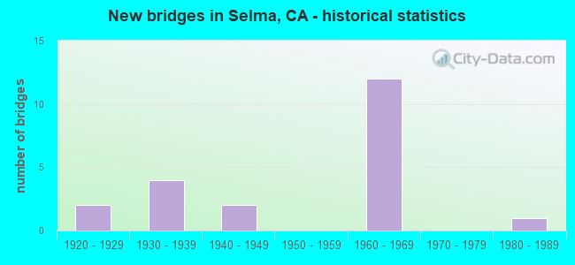
- New bridges - historical statistics
- 21920-1929
- 41930-1939
- 21940-1949
- 121960-1969
- 11980-1989

- Reconstructed bridges - Historical Statistics
- 11940-1949
- 01950-1959
- 11960-1969
- 11970-1979
- 01980-1989
- 01990-1999
- 42000-2009


- Bridge Condition - Deck
- 61.5%Good
- 38.5%Fair

- Bridge Condition - Superstructure
- 69.2%Good
- 30.8%Fair

- Bridge Condition - Substructure
- 38.5%Good
- 61.5%Fair

- Bridge Condition - Channel
- 9.1%Very good
- 90.9%Good
Find on map >> Show street view
Structure Number: 42 0125, Location: 06-FRE-099-7.83-SEL (Lat: 36.590853, Lng: -119.644997), Route carried "on" structure: State highway 99, Year Built: 1962, Status: Open, Structure Length: 0.73m (2.40ft), Average Daily Traffic: 78,000 (year 2009), Truck Traffic: 24%, Average Future Daily Traffic: 118,406 (year 2042), Features Intersected: FOWLER SWITCH CANAL
Minimum Vertical Clearance: 30+ m (98+ ft), Kilometerpoint: 7.830, Lanes on structure: 6, Base Highway Network: Yes (, Subroute: 1), Owner: State Highway Agency, Approaching Roadway Width: 40.8m (133.9ft), Skew: 24 degrees, Material/Design: Concrete continuous, Design/Construction: Culvert, Number Of Spans In Main Unit: 2, Length of Maximum Span: 3.7m (12.1ft)
Condition: Channel: Very good, Culverts: Satisfactory, Operating Rating: 54.1 metric tons, Method Used To Determine Operating Rating: Field evaluation and documented engineering judgment, Inventory Rating: 32.4 metric tons, Method Used To Determine Inventory Rating: Field evaluation and documented engineering judgment, Structural Evaluation: Equal to present minimum criteria, Waterway Adequacy: Equal to present minimum criteria, Approach Roadway Alignment: Equal to present desirable criteria, Designated Inspection Frequency: Every 24 months, Inspection Date: April 2020
Find on map >> Show street view
Structure Number: 42 0199, Location: 06-FRE-099-6.41-SEL (Lat: 36.575761, Lng: -119.628397), Route carried "on" structure: State highway 99, Year Built: 1962, Year Reconstructed: 2007, Status: Open, Structure Length: 7.33m (24.05ft), Average Daily Traffic: 57,000 (year 2009), Truck Traffic: 24%, Average Future Daily Traffic: 95,738 (year 2043), Design Load: HS 20+Mod, Features Intersected: HIGHLAND AVENUE
Minimum Vertical Clearance: 30+ m (98+ ft), Kilometerpoint: 6.410, Lanes on structure: 7, Lanes under structure: 4, Base Highway Network: Yes (, Subroute: 1), Owner: State Highway Agency, Approaching Roadway Width: 35.8m (117.5ft), Skew: 34 degrees, Material/Design: Concrete continuous, Design/Construction: Box Beam or Girders - Multiple, Number Of Spans In Main Unit: 4, Length of Maximum Span: 21.8m (71.5ft), Curb-To-Curb Width: 36.6m (120.1ft), Out-to-Out Width: 38.0m (124.7ft)
Condition: Deck: Good, Superstructure: Good, Substructure: Good, Operating Rating: 54.1 metric tons, Method Used To Determine Operating Rating: Assigned rating based on Load Factor Design (LFD) reported in metric tons, Inventory Rating: 32.4 metric tons, Method Used To Determine Inventory Rating: Assigned rating based on Load Factor Design (LFD) reported in metric tons, Structural Evaluation: Better than present minimum criteria, Deck Geometry: Superior to present desirable criteria, Underclear: Meets minimum limits, Approach Roadway Alignment: Equal to present desirable criteria, Designated Inspection Frequency: Every 24 months, Inspection Date: April 2021, Deck Structure Type: Concrete Cast-file-Place
Find on map >> Show street view
Structure Number: 42 02, Location: 06-FRE-099-6.51-SEL (Lat: 36.576636, Lng: -119.629408), Route carried "on" structure: State highway 99, Year Built: 1962, Year Reconstructed: 2008, Status: Open, Structure Length: 4.31m (14.14ft), Average Daily Traffic: 57,000 (year 2009), Truck Traffic: 24%, Average Future Daily Traffic: 108,339 (year 2039), Design Load: HS 20+Mod, Features Intersected: FLORAL AVE
Minimum Vertical Clearance: 30+ m (98+ ft), Kilometerpoint: 6.510, Lanes on structure: 7, Lanes under structure: 5, Base Highway Network: Yes (, Subroute: 1), Owner: State Highway Agency, Approaching Roadway Width: 37.7m (123.7ft), Skew: 32 degrees, Material/Design: Concrete continuous, Design/Construction: Box Beam or Girders - Multiple, Number Of Spans In Main Unit: 3, Length of Maximum Span: 21.0m (68.9ft), Curb-To-Curb Width: 37.7m (123.7ft), Out-to-Out Width: 39.2m (128.6ft)
Condition: Deck: Good, Superstructure: Good, Substructure: Good, Operating Rating: 39.2 metric tons, Method Used To Determine Operating Rating: Load and Resistance Factor Rating (LRFR) rating reported by rating factor(RF) method using HL-93 loadings, Inventory Rating: 29.8 metric tons, Method Used To Determine Inventory Rating: Load and Resistance Factor Rating (LRFR) rating reported by rating factor(RF) method using HL-93 loadings, Structural Evaluation: Better than present minimum criteria, Deck Geometry: Superior to present desirable criteria, Underclear: Meets minimum limits, Approach Roadway Alignment: Equal to present desirable criteria, Designated Inspection Frequency: Every 24 months, Inspection Date: April 2021, Deck Structure Type: Concrete Cast-file-Place
Find on map >> Show street view
Structure Number: 42 0221, Location: 06-FRE-099-R5.32-SEL (Lat: 36.563894, Lng: -119.615436), Route carried "on" structure: State highway 99, Year Built: 1964, Year Reconstructed: 2008, Status: Open, Structure Length: 4.75m (15.58ft), Average Daily Traffic: 57,000 (year 2009), Truck Traffic: 24%, Average Future Daily Traffic: 94,000 (year 2039), Design Load: HS 20+Mod, Features Intersected: SECOND STREET
Minimum Vertical Clearance: 30+ m (98+ ft), Kilometerpoint: 5.320, Lanes on structure: 6, Lanes under structure: 5, Base Highway Network: Yes (, Subroute: 1), Owner: State Highway Agency, Approaching Roadway Width: 34.1m (111.9ft), Skew: 30 degrees, Material/Design: Concrete continuous, Design/Construction: Box Beam or Girders - Multiple, Number Of Spans In Main Unit: 4, Length of Maximum Span: 17.1m (56.1ft), Curb-To-Curb Width: 34.0m (111.5ft), Out-to-Out Width: 35.4m (116.1ft)
Condition: Deck: Good, Superstructure: Good, Substructure: Good, Operating Rating: 51.8 metric tons, Method Used To Determine Operating Rating: Load Factor (LF), Inventory Rating: 31.1 metric tons, Method Used To Determine Inventory Rating: Load Factor (LF), Structural Evaluation: Better than present minimum criteria, Deck Geometry: Superior to present desirable criteria, Underclear: Meets minimum limits, Approach Roadway Alignment: Equal to present desirable criteria, Designated Inspection Frequency: Every 24 months, Inspection Date: April 2021, Deck Structure Type: Concrete Cast-file-Place, Wearing Surface/Protective System: Wearing Surface: Integral Concrete
Find on map >> Show street view
Structure Number: 42 0222, Location: 06-FRE-099-R5.77-SEL (Lat: 36.568717, Lng: -119.620736), Route carried "on" structure: State highway 99, Year Built: 1964, Year Reconstructed: 2008, Status: Open, Structure Length: 4.94m (16.21ft), Average Daily Traffic: 57,000 (year 2009), Truck Traffic: 24%, Average Future Daily Traffic: 97,637 (year 2043), Design Load: HS 20+Mod, Features Intersected: ROSE AVE
Minimum Vertical Clearance: 30+ m (98+ ft), Kilometerpoint: 5.770, Lanes on structure: 6, Lanes under structure: 2, Base Highway Network: Yes (, Subroute: 1), Owner: State Highway Agency, Approaching Roadway Width: 34.2m (112.2ft), Skew: 34 degrees, Material/Design: Concrete continuous, Design/Construction: Box Beam or Girders - Multiple, Number Of Spans In Main Unit: 3, Length of Maximum Span: 25.0m (82.0ft), Curb-To-Curb Width: 34.2m (112.2ft), Out-to-Out Width: 35.7m (117.1ft)
Condition: Deck: Good, Superstructure: Good, Substructure: Good, Operating Rating: 54.1 metric tons, Method Used To Determine Operating Rating: Assigned rating based on Load Factor Design (LFD) reported in metric tons, Inventory Rating: 32.4 metric tons, Method Used To Determine Inventory Rating: Assigned rating based on Load Factor Design (LFD) reported in metric tons, Structural Evaluation: Better than present minimum criteria, Deck Geometry: Superior to present desirable criteria, Underclear: Equal to present minimum criteria, Approach Roadway Alignment: Equal to present desirable criteria, Designated Inspection Frequency: Every 24 months, Inspection Date: April 2021, Deck Structure Type: Concrete Cast-file-Place, Wearing Surface/Protective System: Wearing Surface: Integral Concrete
Find on map >> Show street view
Structure Number: 42C0038, Location: 1.0 MI W OF MCCALL AVE (Lat: 36.605356, Lng: -119.628606), Route carried "on" structure: County highway , Year Built: 1938, Year Reconstructed: 1982, Status: Open, Structure Length: 1.46m (4.79ft), Average Daily Traffic: 4,200 (year 2010), Truck Traffic: 16%, Average Future Daily Traffic: 16,686 (year 2042), Features Intersected: FOWLER SWITCH CANAL, Facility Carried by Structure: E MANNING AVE
Minimum Vertical Clearance: 30+ m (98+ ft), Kilometerpoint: 0.000, Lanes on structure: 4, Owner: County Highway Agency, Approaching Roadway Width: 20.4m (66.9ft), Skew: 20 degrees, Material/Design: Concrete continuous, Design/Construction: Slab, Number Of Spans In Main Unit: 4, Length of Maximum Span: 3.6m (11.8ft), Curb-To-Curb Width: 20.4m (66.9ft), Out-to-Out Width: 26.9m (88.3ft)
Condition: Deck: Fair, Superstructure: Fair, Substructure: Fair, Channel: Good, Operating Rating: 26.9 metric tons, Method Used To Determine Operating Rating: Field evaluation and documented engineering judgment, Inventory Rating: 16.2 metric tons, Method Used To Determine Inventory Rating: Field evaluation and documented engineering judgment, Structural Evaluation: Meets minimum limits, Deck Geometry: Superior to present desirable criteria, Waterway Adequacy: Equal to present desirable criteria, Approach Roadway Alignment: Equal to present desirable criteria, Designated Inspection Frequency: Every 24 months, Inspection Date: January 2022, Deck Structure Type: Concrete Cast-file-Place, Wearing Surface/Protective System: Wearing Surface: Bituminous
Find on map >> Show street view
Structure Number: 42C025, Location: 0.1 MI E OF CRAWFORD AVE (Lat: 36.661483, Lng: -119.374875), Route carried "on" structure: County highway , Year Built: 1980, Status: Open, Structure Length: 1.92m (6.30ft), Average Daily Traffic: 1,100 (year 2006), Truck Traffic: 5%, Average Future Daily Traffic: 1,715 (year 2040), Design Load: HS 20+Mod, Features Intersected: ALTA EAST BRANCH CANAL, Facility Carried by Structure: E AMERICAN AVE
Minimum Vertical Clearance: 30+ m (98+ ft), Kilometerpoint: 0.000, Lanes on structure: 2, Owner: County Highway Agency, Approaching Roadway Width: 7.3m (24.0ft), Skew: 2 degrees, Material/Design: Concrete continuous, Design/Construction: Slab, Number Of Spans In Main Unit: 2, Length of Maximum Span: 9.1m (29.9ft), Curb-To-Curb Width: 8.5m (27.9ft), Out-to-Out Width: 8.7m (28.5ft)
Condition: Deck: Good, Superstructure: Good, Substructure: Fair, Channel: Good, Operating Rating: 97.2 metric tons, Method Used To Determine Operating Rating: Load Factor (LF), Inventory Rating: 58.3 metric tons, Method Used To Determine Inventory Rating: Load Factor (LF), Structural Evaluation: Somewhat better than minimum adequacy, Deck Geometry: Somewhat better than minimum adequacy, Waterway Adequacy: Better than present minimum criteria, Approach Roadway Alignment: Equal to present desirable criteria, Designated Inspection Frequency: Every 24 months, Inspection Date: November 2020, Deck Structure Type: Concrete Cast-file-Place, Wearing Surface/Protective System: Wearing Surface: Bituminous
Find on map >> Show street view
Structure Number: 42C0258, Location: AT (E/O) ORANGE AVE (Lat: 36.576142, Lng: -119.603594), Route carried "on" structure: City street , Year Built: 1936, Status: Open, Structure Length: 0.65m (2.13ft), Average Daily Traffic: 5,650 (year 2011), Truck Traffic: 5%, Average Future Daily Traffic: 8,900 (year 2042), Features Intersected: SELMA BRANCH C & K CANAL, Facility Carried by Structure: E FLORAL AVE
Minimum Vertical Clearance: 30+ m (98+ ft), Kilometerpoint: 0.000, Lanes on structure: 2, Owner: City or Municipal Highway Agency, Approaching Roadway Width: 13.4m (44.0ft), Skew: 2 degrees, Material/Design: Concrete continuous, Design/Construction: Culvert, Number Of Spans In Main Unit: 2, Length of Maximum Span: 3.0m (9.8ft), Curb or Sidewalk Widths: Left: 1.5m (4.9ft), Right: 1.5m (4.9ft), Curb-To-Curb Width: 13.4m (44.0ft), Out-to-Out Width: 16.8m (55.1ft)
Condition: Channel: Good, Culverts: Satisfactory, Operating Rating: 27.2 metric tons, Method Used To Determine Operating Rating: Field evaluation and documented engineering judgment, Inventory Rating: 16.2 metric tons, Method Used To Determine Inventory Rating: Field evaluation and documented engineering judgment, Structural Evaluation: Meets minimum limits, Deck Geometry: Equal to present minimum criteria, Waterway Adequacy: Equal to present desirable criteria, Approach Roadway Alignment: Equal to present desirable criteria, Designated Inspection Frequency: Every 24 months, Inspection Date: January 2022, Deck Structure Type: Concrete Cast-file-Place, Wearing Surface/Protective System: Wearing Surface: Bituminous
Find on map >> Show street view
Structure Number: 42C0318, Location: 0.7 MI EAST OF FOWLER AVE (Lat: 36.568847, Lng: -119.670078), Route carried "on" structure: County highway , Year Built: 1945, Status: Open, Structure Length: 0.70m (2.30ft), Average Daily Traffic: 100 (year 1999), Truck Traffic: 10%, Average Future Daily Traffic: 218 (year 2042), Features Intersected: CROSSCUT CANAL, Facility Carried by Structure: E ROSE AVE
Minimum Vertical Clearance: 30+ m (98+ ft), Kilometerpoint: 0.000, Lanes on structure: 2, Owner: County Highway Agency, Approaching Roadway Width: 7.0m (23.0ft), Material/Design: Wood or Timber, Design/Construction: Slab, Number Of Spans In Main Unit: 2, Length of Maximum Span: 3.4m (11.2ft), Curb or Sidewalk Widths: Left: 0.2m (0.7ft), Right: 0.2m (0.7ft), Curb-To-Curb Width: 7.0m (23.0ft), Out-to-Out Width: 7.5m (24.6ft)
Condition: Deck: Good, Superstructure: Good, Substructure: Fair, Channel: Good, Operating Rating: 29.5 metric tons, Method Used To Determine Operating Rating: Allowable Stress (AS), Inventory Rating: 22.0 metric tons, Method Used To Determine Inventory Rating: Allowable Stress (AS), Structural Evaluation: Somewhat better than minimum adequacy, Deck Geometry: Somewhat better than minimum adequacy, Waterway Adequacy: Equal to present desirable criteria, Approach Roadway Alignment: Equal to present desirable criteria, Designated Inspection Frequency: Every 24 months, Inspection Date: January 2022, Deck Structure Type: Wood or Timber, Wearing Surface/Protective System: Wearing Surface: Bituminous
Find on map >> Show street view
Structure Number: 42C0363, Location: 0.9 MI E OF FOWLER AV (Lat: 36.561572, Lng: -119.666872), Route carried "on" structure: County highway , Year Built: 1925, Year Reconstructed: 1951, Status: Open, Structure Length: 0.73m (2.40ft), Average Daily Traffic: 2,100 (year 2007), Truck Traffic: 10%, Average Future Daily Traffic: 3,559 (year 2042), Features Intersected: CROSSCUT CANAL, Facility Carried by Structure: E NEBRASKA AVE
Minimum Vertical Clearance: 30+ m (98+ ft), Kilometerpoint: 0.000, Lanes on structure: 2, Owner: County Highway Agency, Approaching Roadway Width: 7.6m (24.9ft), Material/Design: Concrete continuous, Design/Construction: Slab, Number Of Spans In Main Unit: 2, Length of Maximum Span: 3.6m (11.8ft), Curb or Sidewalk Widths: Left: 0.2m (0.7ft), Right: 0.2m (0.7ft), Curb-To-Curb Width: 10.2m (33.5ft), Out-to-Out Width: 11.0m (36.1ft)
Condition: Deck: Good, Superstructure: Good, Substructure: Fair, Channel: Good, Operating Rating: 26.9 metric tons, Method Used To Determine Operating Rating: Field evaluation and documented engineering judgment, Inventory Rating: 16.2 metric tons, Method Used To Determine Inventory Rating: Field evaluation and documented engineering judgment, Structural Evaluation: Meets minimum limits, Deck Geometry: Meets minimum limits, Waterway Adequacy: Equal to present desirable criteria, Approach Roadway Alignment: Equal to present desirable criteria, Designated Inspection Frequency: Every 24 months, Inspection Date: January 2022, Deck Structure Type: Concrete Cast-file-Place, Wearing Surface/Protective System: Wearing Surface: Bituminous
Find on map >> Show street view
Structure Number: 42C0446, Location: JUST EAST OF HIGHLAND AVE (Lat: 36.619831, Lng: -119.627636), Route carried "on" structure: County highway , Year Built: 1948, Status: Open, Structure Length: 1.55m (5.09ft), Average Daily Traffic: 500 (year 1999), Truck Traffic: 10%, Average Future Daily Traffic: 1,095 (year 2042), Features Intersected: FOWLER SWITCH CANAL, Facility Carried by Structure: E SOUTH AVE
Minimum Vertical Clearance: 30+ m (98+ ft), Kilometerpoint: 0.000, Lanes on structure: 2, Owner: County Highway Agency, Approaching Roadway Width: 6.9m (22.6ft), Skew: 1 degrees, Material/Design: Concrete continuous, Design/Construction: Slab, Number Of Spans In Main Unit: 4, Length of Maximum Span: 3.7m (12.1ft), Curb or Sidewalk Widths: Left: 0.1m (0.3ft), Right: 0.1m (0.3ft), Curb-To-Curb Width: 6.9m (22.6ft), Out-to-Out Width: 7.3m (24.0ft)
Condition: Deck: Good, Superstructure: Good, Substructure: Fair, Channel: Good, Operating Rating: 31.8 metric tons, Method Used To Determine Operating Rating: Load Factor (LF), Inventory Rating: 19.1 metric tons, Method Used To Determine Inventory Rating: Load Factor (LF), Structural Evaluation: Somewhat better than minimum adequacy, Deck Geometry: Meets minimum limits, Waterway Adequacy: Equal to present desirable criteria, Approach Roadway Alignment: Equal to present desirable criteria, Designated Inspection Frequency: Every 24 months, Inspection Date: January 2022, Deck Structure Type: Concrete Cast-file-Place, Wearing Surface/Protective System: Wearing Surface: Bituminous
Find on map >> Show street view
Structure Number: 42C0447, Location: 0.7 MI S OF MANNING AVE (Lat: 36.595422, Lng: -119.637514), Route carried "on" structure: County highway , Year Built: 1936, Year Reconstructed: 1972, Status: Open, Structure Length: 1.74m (5.71ft), Average Daily Traffic: 600 (year 2002), Truck Traffic: 10%, Average Future Daily Traffic: 438 (year 2042), Design Load: HS 20+Mod, Features Intersected: FOWLER SWITCH CANAL, Facility Carried by Structure: S LEONARD AVE
Minimum Vertical Clearance: 30+ m (98+ ft), Kilometerpoint: 0.000, Lanes on structure: 2, Owner: County Highway Agency, Approaching Roadway Width: 6.7m (22.0ft), Skew: 4 degrees, Material/Design: Concrete continuous, Design/Construction: Slab, Number Of Spans In Main Unit: 3, Length of Maximum Span: 5.8m (19.0ft), Curb-To-Curb Width: 6.7m (22.0ft), Out-to-Out Width: 6.9m (22.6ft)
Condition: Deck: Fair, Superstructure: Fair, Substructure: Fair, Channel: Good, Operating Rating: 51.8 metric tons, Method Used To Determine Operating Rating: Load Factor (LF), Inventory Rating: 31.1 metric tons, Method Used To Determine Inventory Rating: Load Factor (LF), Structural Evaluation: Somewhat better than minimum adequacy, Deck Geometry: Meets minimum limits, Waterway Adequacy: Equal to present desirable criteria, Approach Roadway Alignment: Equal to present desirable criteria, Designated Inspection Frequency: Every 24 months, Inspection Date: January 2022, Deck Structure Type: Concrete Cast-file-Place
Find on map >> Show street view
Structure Number: 42C0448, Location: AT DINUBA AVE (Lat: 36.590894, Lng: -119.646375), Route carried "on" structure: County highway , Year Built: 1938, Status: Open, Structure Length: 1.34m (4.40ft), Average Daily Traffic: 800 (year 2003), Truck Traffic: 10%, Average Future Daily Traffic: 2,272 (year 2044), Features Intersected: FOWLER SWITCH CANAL, Facility Carried by Structure: S DE WOLF AVE
Minimum Vertical Clearance: 30+ m (98+ ft), Kilometerpoint: 0.000, Lanes on structure: 2, Owner: County Highway Agency, Approaching Roadway Width: 5.5m (18.0ft), Material/Design: Concrete continuous, Design/Construction: Slab, Number Of Spans In Main Unit: 3, Length of Maximum Span: 7.3m (24.0ft), Curb-To-Curb Width: 6.7m (22.0ft), Out-to-Out Width: 7.2m (23.6ft)
Condition: Deck: Fair, Superstructure: Fair, Substructure: Fair, Channel: Good, Operating Rating: 58.0 metric tons, Method Used To Determine Operating Rating: Load Factor (LF), Inventory Rating: 34.7 metric tons, Method Used To Determine Inventory Rating: Load Factor (LF), Structural Evaluation: Somewhat better than minimum adequacy, Deck Geometry: Meets minimum limits, Waterway Adequacy: Equal to present desirable criteria, Approach Roadway Alignment: High priority of corrective action, Designated Inspection Frequency: Every 24 months, Inspection Date: January 2022, Deck Structure Type: Concrete Cast-file-Place, Wearing Surface/Protective System: Wearing Surface: Bituminous
Find on map >> Show street view
Structure Number: 42C0449, Location: 0.7 MI E OF FOWLER AVE (Lat: 36.576367, Lng: -119.668364), Route carried "on" structure: County highway , Year Built: 1964, Status: Open, Structure Length: 1.65m (5.41ft), Average Daily Traffic: 2,200 (year 2012), Truck Traffic: 10%, Average Future Daily Traffic: 2,892 (year 2042), Design Load: HS 20+Mod, Features Intersected: FOWLER SWITCH CANAL, Facility Carried by Structure: E FLORAL AVE
Minimum Vertical Clearance: 30+ m (98+ ft), Kilometerpoint: 0.000, Lanes on structure: 2, Owner: County Highway Agency, Approaching Roadway Width: 6.7m (22.0ft), Skew: 1 degrees, Material/Design: Concrete continuous, Design/Construction: Slab, Number Of Spans In Main Unit: 2, Length of Maximum Span: 8.1m (26.6ft), Curb-To-Curb Width: 9.8m (32.2ft), Out-to-Out Width: 9.9m (32.5ft)
Condition: Deck: Fair, Superstructure: Fair, Substructure: Good, Channel: Good, Operating Rating: 58.3 metric tons, Method Used To Determine Operating Rating: Load Factor (LF), Inventory Rating: 35.0 metric tons, Method Used To Determine Inventory Rating: Load Factor (LF), Structural Evaluation: Somewhat better than minimum adequacy, Deck Geometry: Meets minimum limits, Waterway Adequacy: Equal to present desirable criteria, Approach Roadway Alignment: Equal to present desirable criteria, Designated Inspection Frequency: Every 24 months, Inspection Date: January 2022, Deck Structure Type: Concrete Cast-file-Place, Wearing Surface/Protective System: Wearing Surface: Bituminous
Find on map >> Show street view
Structure Number: 42C0532, Location: 0.3 MI E OF TEMPERANCE AV (Lat: 36.583625, Lng: -119.659769), Route carried "on" structure: County highway , Year Built: 1925, Status: Open, Structure Length: 2.16m (7.09ft), Average Daily Traffic: 300 (year 2010), Truck Traffic: 10%, Average Future Daily Traffic: 657 (year 2042), Features Intersected: FOWLER SWITCH CANAL, Facility Carried by Structure: E HUNTSMAN AVE
Minimum Vertical Clearance: 30+ m (98+ ft), Kilometerpoint: 0.000, Lanes on structure: 2, Owner: County Highway Agency, Approaching Roadway Width: 5.2m (17.1ft), Skew: 4 degrees, Material/Design: Wood or Timber, Design/Construction: Stringer/Multi-beam, Number Of Spans In Main Unit: 4, Length of Maximum Span: 5.3m (17.4ft), Curb-To-Curb Width: 7.0m (23.0ft), Out-to-Out Width: 7.7m (25.3ft)
Condition: Deck: Fair, Superstructure: Good, Substructure: Fair, Channel: Good, Operating Rating: 26.9 metric tons, Method Used To Determine Operating Rating: Allowable Stress (AS), Inventory Rating: 20.4 metric tons, Method Used To Determine Inventory Rating: Allowable Stress (AS), Structural Evaluation: Somewhat better than minimum adequacy, Deck Geometry: Meets minimum limits, Waterway Adequacy: Equal to present desirable criteria, Approach Roadway Alignment: Equal to present desirable criteria, Designated Inspection Frequency: Every 24 months, Inspection Date: January 2022, Deck Structure Type: Concrete Cast-file-Place
Find on map >> Show street view
Structure Number: 42 0199, Location: 06-FRE-099-6.41-SEL (Lat: 36.575761, Lng: -119.628397), Route carried "under" structure: State highway 43, Year Built: 1962, Structure Length: 0. m, Average Daily Traffic: 23,995 (year 2016), Truck Traffic: 20%, Features Intersected: HIGHLAND AVENUE, Facility Carried by Structure: STATE ROUTE 99
Minimum Vertical Clearance: 4.64m (15.22ft), Kilometerpoint: 9.300, Lanes on structure: 7, Lanes under structure: 4, Material/Design: Concrete continuous, Design/Construction: Box Beam or Girders - Multiple, Length of Maximum Span: 21.8m (71.5ft)
Find on map >> Show street view
Structure Number: 42 02, Location: 06-FRE-099-6.51-SEL (Lat: 36.576636, Lng: -119.629408), Route carried "under" structure: County highway Z437, Year Built: 1962, Structure Length: 0. m, Average Daily Traffic: 14,786 (year 2015), Truck Traffic: 20%, Features Intersected: FLORAL AVE, Facility Carried by Structure: STATE ROUTE 99
Minimum Vertical Clearance: 4.62m (15.16ft), Kilometerpoint: 0.000, Lanes on structure: 7, Lanes under structure: 5, Material/Design: Concrete continuous, Design/Construction: Box Beam or Girders - Multiple, Length of Maximum Span: 21.0m (68.9ft)
Find on map >> Show street view
Structure Number: 42 0200K, Location: 06-FRE-099-6.50-SEL (Lat: 36.576503, Lng: -119.629928), Route carried "under" structure: County highway Z437, Year Built: 1962, Structure Length: 0. m, Average Daily Traffic: 14,786 (year 2015), Truck Traffic: 20%, Features Intersected: FLORAL AVE, Facility Carried by Structure: SB 99-HIGHLAND OFF
Minimum Vertical Clearance: 4.62m (15.16ft), Kilometerpoint: 0.000, Lanes on structure: 1, Lanes under structure: 5, Material/Design: Concrete continuous, Design/Construction: Box Beam or Girders - Multiple, Length of Maximum Span: 21.0m (68.9ft)
Find on map >> Show street view
Structure Number: 42 022, Location: 06-FRE-099-R4.91-SEL (Lat: 36.559550, Lng: -119.610639), Route carried "under" structure: Business City street , Year Built: 1964, Structure Length: 0. m, Average Daily Traffic: 3,600 (year 2017), Truck Traffic: 20%, Features Intersected: MCCALL AVE, Facility Carried by Structure: STATE ROUTE 99
Minimum Vertical Clearance: 4.69m (15.39ft), Kilometerpoint: 0.000, Lanes on structure: 6, Lanes under structure: 2, Material/Design: Concrete continuous, Design/Construction: Box Beam or Girders - Multiple, Length of Maximum Span: 28.7m (94.2ft)
Find on map >> Show street view
Structure Number: 42 0221, Location: 06-FRE-099-R5.32-SEL (Lat: 36.563894, Lng: -119.615436), Route carried "under" structure: City street Z440, Year Built: 1964, Structure Length: 0. m, Average Daily Traffic: 17,500 (year 2017), Truck Traffic: 20%, Features Intersected: SECOND STREET, Facility Carried by Structure: STATE ROUTE 99
Minimum Vertical Clearance: 4.45m (14.60ft), Kilometerpoint: 0.000, Lanes on structure: 6, Lanes under structure: 5, Material/Design: Concrete continuous, Design/Construction: Box Beam or Girders - Multiple, Length of Maximum Span: 17.1m (56.1ft)
Find on map >> Show street view
Structure Number: 42 0222, Location: 06-FRE-099-R5.77-SEL (Lat: 36.568717, Lng: -119.620736), Route carried "under" structure: County highway Z438, Year Built: 1964, Structure Length: 0. m, Average Daily Traffic: 7,511 (year 2017), Truck Traffic: 20%, Features Intersected: ROSE AVE, Facility Carried by Structure: STATE ROUTE 99
Minimum Vertical Clearance: 5.00m (16.40ft), Kilometerpoint: 0.000, Lanes on structure: 6, Lanes under structure: 2, Material/Design: Concrete continuous, Design/Construction: Box Beam or Girders - Multiple, Length of Maximum Span: 25.0m (82.0ft)