Bridge Statistics for Selma, Texas (TX)
Condition, Traffic, Stress, Structural Evaluation, Project Costs
- National Bridge Inventory (NBI) Statistics
- 21Number of bridges
- 522ft / 159mTotal length
- $44,000Total costs
- 725,112Total average daily traffic
- 72,569Total average daily truck traffic
- National Bridge Inventory (NBI) Registered Bridges for Selma
- No street view available for this location
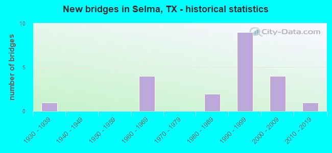
- New bridges - historical statistics
- 11930-1939
- 41960-1969
- 21980-1989
- 91990-1999
- 42000-2009
- 12010-2019
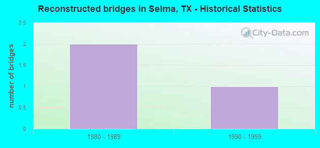
- Reconstructed bridges - Historical Statistics
- 21980-1989
- 11990-1999
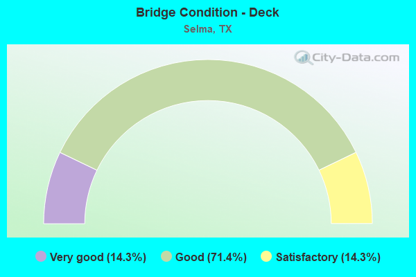
- Bridge Condition - Deck
- 14.3%Very good
- 71.4%Good
- 14.3%Satisfactory
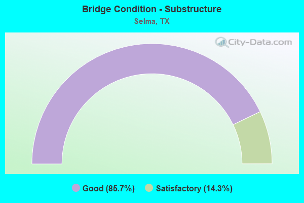
- Bridge Condition - Substructure
- 85.7%Good
- 14.3%Satisfactory
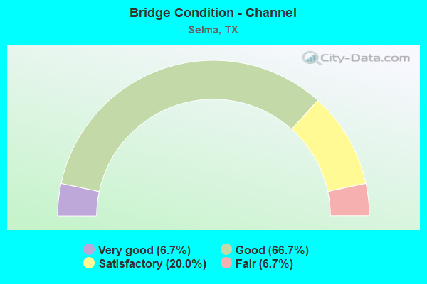
- Bridge Condition - Channel
- 6.7%Very good
- 66.7%Good
- 20.0%Satisfactory
- 6.7%Fair
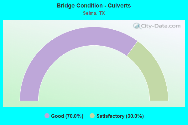
- Bridge Condition - Culverts
- 70.0%Good
- 30.0%Satisfactory
Find on map >> Show street view
Structure Number: 150150001607095, Location: 1.16 MI S OF CIBOLO CREEK (Lat: 29.577508, Lng: -98.320411), Route carried "on" structure: ServiceInterstate 35, Year Built: 1960, Year Reconstructed: 1987, Status: Open, Structure Length: 0.98m (3.22ft), Average Daily Traffic: 11,110 (year 2010), Truck Traffic: 3%, Average Future Daily Traffic: 15,550 (year 2030), Design Load: HS 20, Features Intersected: DRAW
Minimum Vertical Clearance: 30+ m (98+ ft), Kilometerpoint: 63.368, Lanes on structure: 2, Owner: State Highway Agency, Approaching Roadway Width: 10.1m (33.1ft), Skew: 5 degrees, Material/Design: Concrete, Design/Construction: Culvert, Number Of Spans In Main Unit: 3, Length of Maximum Span: 3.0m (9.8ft)
Condition: Channel: Good, Culverts: Good, Operating Rating: 39.9 metric tons, Method Used To Determine Operating Rating: Load Factor (LF), Inventory Rating: 23.6 metric tons, Method Used To Determine Inventory Rating: Load Factor (LF), Structural Evaluation: Somewhat better than minimum adequacy, Waterway Adequacy: Better than present minimum criteria, Approach Roadway Alignment: Equal to present desirable criteria, Designated Inspection Frequency: Every 24 months, Inspection Date: May 2020
Find on map >> Show street view
Structure Number: 150150001607096, Location: 1.16 MI S OF CIBOLO CREEK (Lat: 29.577525, Lng: -98.321111), Route carried "on" structure: City street , Year Built: 1960, Status: Open, Structure Length: 9.30m (30.51ft), Average Daily Traffic: 3,700 (year 2011), Average Future Daily Traffic: 5,000 (year 2031), Design Load: H 20, Features Intersected: IH 35, Facility Carried by Structure: OLYMPIA PKWY
Minimum Vertical Clearance: 30+ m (98+ ft), Kilometerpoint: 1.609, Lanes on structure: 2, Lanes under structure: 12, Owner: State Highway Agency, Approaching Roadway Width: 7.6m (24.9ft), Material/Design: Prestressed concrete, Design/Construction: Stringer/Multi-beam, Number Of Spans In Main Unit: 5, Length of Maximum Span: 19.8m (65.0ft), Curb-To-Curb Width: 8.0m (26.2ft), Out-to-Out Width: 9.5m (31.2ft)
Condition: Deck: Satisfactory, Superstructure: Good, Substructure: Satisfactory, Operating Rating: 68.0 metric tons, Method Used To Determine Operating Rating: Load Factor (LF), Inventory Rating: 36.3 metric tons, Method Used To Determine Inventory Rating: Load Factor (LF), Structural Evaluation: Equal to present minimum criteria, Deck Geometry: High priority of corrective action, Underclear: High priority of corrective action, Approach Roadway Alignment: Better than present minimum criteria, Length Of Structure Improvement: 9.30m (30.51ft), Designated Inspection Frequency: Every 24 months, Inspection Date: May 2020, Bridge Improvement Cost: $16,000, Roadway Improvement Cost: $4,000, Total Project Cost: $20,000, Deck Structure Type: Concrete Cast-file-Place, Wearing Surface/Protective System: Wearing Surface: Bituminous
Find on map >> Show street view
Structure Number: 150150001607165, Location: 0.35 MI N E OF LOOP 1604 (Lat: 29.572667, Lng: -98.327678), Route carried "on" structure: City street , Year Built: 1986, Status: Open, Structure Length: 4.79m (15.72ft), Average Daily Traffic: 132,930 (year 2010), Average Future Daily Traffic: 20 (year 2030), Design Load: HS 20, Features Intersected: IH 35 ML, Facility Carried by Structure: FORUM PARKWAY
Minimum Vertical Clearance: 30+ m (98+ ft), Kilometerpoint: 0.805, Lanes on structure: 4, Lanes under structure: 10, Owner: State Highway Agency, Approaching Roadway Width: 13.4m (44.0ft), Material/Design: Prestressed concrete, Design/Construction: Box Beam or Girders - Multiple, Number Of Spans In Main Unit: 2, Length of Maximum Span: 25.6m (84.0ft), Curb or Sidewalk Widths: Left: 1.1m (3.6ft), Right: 1.1m (3.6ft), Curb-To-Curb Width: 18.4m (60.4ft), Out-to-Out Width: 23.1m (75.8ft)
Condition: Deck: Very good, Superstructure: Good, Substructure: Good, Operating Rating: 54.4 metric tons, Method Used To Determine Operating Rating: Assigned rating based on Load Factor Design (LFD) reported in metric tons, Inventory Rating: 32.7 metric tons, Method Used To Determine Inventory Rating: Assigned rating based on Load Factor Design (LFD) reported in metric tons, Structural Evaluation: Better than present minimum criteria, Deck Geometry: Somewhat better than minimum adequacy, Underclear: High priority of corrective action, Approach Roadway Alignment: Equal to present desirable criteria, Length Of Structure Improvement: 4.79m (15.72ft), Designated Inspection Frequency: Every 24 months, Inspection Date: May 2020, Bridge Improvement Cost: $19,000, Roadway Improvement Cost: $5,000, Total Project Cost: $24,000, Deck Structure Type: Other, Wearing Surface/Protective System: Wearing Surface: Bituminous
Find on map >> Show street view
Structure Number: 150150001607174, Location: 0.87 MI N E OF LP 1604 (Lat: 29.576708, Lng: -98.322597), Route carried "on" structure: Interstate 35, Year Built: 1933, Year Reconstructed: 1990, Status: Open, Structure Length: 0.91m (2.99ft), Average Daily Traffic: 130,521 (year 2020), Truck Traffic: 13%, Average Future Daily Traffic: 198,550 (year 2033), Design Load: H 15, Features Intersected: DRAINAGE DITCH
Minimum Vertical Clearance: 30+ m (98+ ft), Kilometerpoint: 63.201, Lanes on structure: 12, Owner: State Highway Agency, Approaching Roadway Width: 57.9m (190.0ft), Skew: 30 degrees, Material/Design: Concrete, Design/Construction: Culvert, Number Of Spans In Main Unit: 5, Length of Maximum Span: 1.5m (4.9ft)
Condition: Channel: Satisfactory, Culverts: Satisfactory, Operating Rating: 39.9 metric tons, Method Used To Determine Operating Rating: Load Factor (LF), Inventory Rating: 23.6 metric tons, Method Used To Determine Inventory Rating: Load Factor (LF), Structural Evaluation: Somewhat better than minimum adequacy, Waterway Adequacy: Equal to present minimum criteria, Approach Roadway Alignment: Equal to present desirable criteria, Designated Inspection Frequency: Every 24 months, Inspection Date: May 2020
Find on map >> Show street view
Structure Number: 150150001607175, Location: 0.01 MI NW OF IH 35 SB FR (Lat: 29.575967, Lng: -98.323078), Route carried "on" structure: ServiceInterstate 35, Year Built: 1960, Year Reconstructed: 1987, Status: Open, Structure Length: 0.70m (2.30ft), Average Daily Traffic: 9,360 (year 2013), Truck Traffic: 13%, Average Future Daily Traffic: 13,100 (year 2033), Design Load: HS 20, Features Intersected: DRAINAGE DITCH
Minimum Vertical Clearance: 30+ m (98+ ft), Kilometerpoint: 63.152, Lanes on structure: 2, Owner: State Highway Agency, Approaching Roadway Width: 7.9m (25.9ft), Skew: 20 degrees, Material/Design: Concrete, Design/Construction: Culvert, Number Of Spans In Main Unit: 4, Length of Maximum Span: 1.5m (4.9ft)
Condition: Channel: Satisfactory, Culverts: Good, Operating Rating: 39.9 metric tons, Method Used To Determine Operating Rating: Load Factor (LF), Inventory Rating: 23.6 metric tons, Method Used To Determine Inventory Rating: Load Factor (LF), Structural Evaluation: Somewhat better than minimum adequacy, Waterway Adequacy: Equal to present minimum criteria, Approach Roadway Alignment: Equal to present desirable criteria, Designated Inspection Frequency: Every 24 months, Inspection Date: May 2020
Find on map >> Show street view
Structure Number: 150150001607183, Location: 0.67 MI S OF CIBOLO CREEK (Lat: 29.580022, Lng: -98.313581), Route carried "on" structure: ServiceInterstate 35, Year Built: 1990, Status: Open, Structure Length: 6.40m (21.00ft), Average Daily Traffic: 10,910 (year 2011), Truck Traffic: 14%, Average Future Daily Traffic: 22,450 (year 2031), Design Load: HS 20, Features Intersected: SELMA CREEK
Minimum Vertical Clearance: 30+ m (98+ ft), Kilometerpoint: 64.054, Lanes on structure: 2, Owner: State Highway Agency, Approaching Roadway Width: 10.4m (34.1ft), Material/Design: Concrete continuous, Design/Construction: Slab, Number Of Spans In Main Unit: 8, Length of Maximum Span: 9.1m (29.9ft), Curb-To-Curb Width: 10.1m (33.1ft), Out-to-Out Width: 11.0m (36.1ft)
Condition: Deck: Good, Superstructure: Good, Substructure: Good, Channel: Good, Operating Rating: 54.4 metric tons, Method Used To Determine Operating Rating: Assigned rating based on Load Factor Design (LFD) reported in metric tons, Inventory Rating: 32.7 metric tons, Method Used To Determine Inventory Rating: Assigned rating based on Load Factor Design (LFD) reported in metric tons, Structural Evaluation: Better than present minimum criteria, Deck Geometry: Meets minimum limits, Waterway Adequacy: Superior to present desirable criteria, Approach Roadway Alignment: Equal to present desirable criteria, Designated Inspection Frequency: Every 24 months, Inspection Date: May 2020, Deck Structure Type: Concrete Cast-file-Place
Find on map >> Show street view
Structure Number: 150150EE0010001, Location: 0.60 MI NE OF LP 1604 (Lat: 29.575592, Lng: -98.327806), Route carried "on" structure: City street , Year Built: 1991, Status: Open, Structure Length: 0.82m (2.69ft), Average Daily Traffic: 690 (year 2013), Average Future Daily Traffic: 1,000 (year 2033), Design Load: HS 20, Features Intersected: DRAW, Facility Carried by Structure: OLD AUSTIN RD
Minimum Vertical Clearance: 30+ m (98+ ft), Kilometerpoint: 0.805, Lanes on structure: 2, Owner: City or Municipal Highway Agency, Approaching Roadway Width: 7.9m (25.9ft), Skew: 1 degrees, Material/Design: Concrete, Design/Construction: Culvert, Number Of Spans In Main Unit: 3, Length of Maximum Span: 2.4m (7.9ft), Curb-To-Curb Width: 9.1m (29.9ft), Out-to-Out Width: 9.8m (32.2ft)
Condition: Channel: Fair, Culverts: Good, Operating Rating: 39.9 metric tons, Method Used To Determine Operating Rating: Load Factor (LF), Inventory Rating: 23.6 metric tons, Method Used To Determine Inventory Rating: Load Factor (LF), Structural Evaluation: Equal to present minimum criteria, Deck Geometry: Equal to present minimum criteria, Waterway Adequacy: Equal to present minimum criteria, Approach Roadway Alignment: Equal to present desirable criteria, Designated Inspection Frequency: Every 24 months, Inspection Date: May 2021, Deck Structure Type: Concrete Cast-file-Place, Wearing Surface/Protective System: Wearing Surface: Bituminous
Find on map >> Show street view
Structure Number: 150150EE0040001, Location: 1.00 MI SW OF COUNTY LINE (Lat: 29.587208, Lng: -98.325350), Route carried "on" structure: City street , Year Built: 1998, Status: Open, Structure Length: 5.18m (16.99ft), Average Daily Traffic: 1,000 (year 2013), Average Future Daily Traffic: 2,000 (year 2033), Design Load: HS 20, Features Intersected: SELMA CREEK, Facility Carried by Structure: LOOKOUT RD
Minimum Vertical Clearance: 30+ m (98+ ft), Kilometerpoint: 1.609, Lanes on structure: 5, Owner: City or Municipal Highway Agency, Approaching Roadway Width: 18.9m (62.0ft), Material/Design: Concrete, Design/Construction: Culvert, Number Of Spans In Main Unit: 16, Length of Maximum Span: 3.0m (9.8ft), Curb-To-Curb Width: 22.4m (73.5ft), Out-to-Out Width: 23.0m (75.5ft)
Condition: Channel: Good, Culverts: Satisfactory, Operating Rating: 39.9 metric tons, Method Used To Determine Operating Rating: Load Factor (LF), Inventory Rating: 23.6 metric tons, Method Used To Determine Inventory Rating: Load Factor (LF), Structural Evaluation: Equal to present minimum criteria, Deck Geometry: Equal to present minimum criteria, Waterway Adequacy: Better than present minimum criteria, Approach Roadway Alignment: Equal to present desirable criteria, Designated Inspection Frequency: Every 24 months, Inspection Date: May 2021, Deck Structure Type: Concrete Cast-file-Place, Wearing Surface/Protective System: Wearing Surface: Bituminous
Find on map >> Show street view
Structure Number: 150150EE0070001, Location: 0.01 MI N OF LOOKOUT RD (Lat: 29.586575, Lng: -98.327431), Route carried "on" structure: City street , Year Built: 2004, Status: Open, Structure Length: 1.95m (6.40ft), Average Daily Traffic: 1,000 (year 2013), Average Future Daily Traffic: 2,000 (year 2033), Design Load: HS 20, Features Intersected: SELMA CREEK, Facility Carried by Structure: AMBERLY COURT
Minimum Vertical Clearance: 30+ m (98+ ft), Kilometerpoint: 0.048, Lanes on structure: 2, Owner: City or Municipal Highway Agency, Approaching Roadway Width: 14.6m (47.9ft), Skew: 20 degrees, Material/Design: Concrete, Design/Construction: Culvert, Number Of Spans In Main Unit: 6, Length of Maximum Span: 3.0m (9.8ft), Curb or Sidewalk Widths: Left: 1.8m (5.9ft), Right: 1.8m (5.9ft), Curb-To-Curb Width: 14.6m (47.9ft), Out-to-Out Width: 22.6m (74.1ft)
Condition: Channel: Good, Culverts: Good, Operating Rating: 54.4 metric tons, Method Used To Determine Operating Rating: Assigned rating based on Load Factor Design (LFD) reported in metric tons, Inventory Rating: 32.7 metric tons, Method Used To Determine Inventory Rating: Assigned rating based on Load Factor Design (LFD) reported in metric tons, Structural Evaluation: Better than present minimum criteria, Deck Geometry: Superior to present desirable criteria, Waterway Adequacy: Better than present minimum criteria, Approach Roadway Alignment: Equal to present desirable criteria, Designated Inspection Frequency: Every 24 months, Inspection Date: May 2021, Deck Structure Type: Concrete Cast-file-Place, Wearing Surface/Protective System: Wearing Surface: Bituminous
Find on map >> Show street view
Structure Number: 150150EE0070002, Location: 0.03 MI S OF RUIDOSO CHAS (Lat: 29.589525, Lng: -98.329564), Route carried "on" structure: City street , Year Built: 2004, Status: Open, Structure Length: 1.36m (4.46ft), Average Daily Traffic: 865 (year 2020), Average Future Daily Traffic: 2,000 (year 2013), Features Intersected: Draw, Facility Carried by Structure: Amberly Ct.
Minimum Vertical Clearance: 30+ m (98+ ft), Kilometerpoint: 0.048, Lanes on structure: 2, Owner: City or Municipal Highway Agency, Approaching Roadway Width: 13.4m (44.0ft), Material/Design: Concrete, Design/Construction: Culvert, Number Of Spans In Main Unit: 5, Length of Maximum Span: 2.4m (7.9ft), Curb or Sidewalk Widths: Left: 2.2m (7.2ft), Right: 2.2m (7.2ft), Curb-To-Curb Width: 13.5m (44.3ft), Out-to-Out Width: 18.3m (60.0ft)
Condition: Channel: Good, Culverts: Good, Operating Rating: 32.7 metric tons, Method Used To Determine Operating Rating: Field evaluation and documented engineering judgment, Inventory Rating: 24.5 metric tons, Method Used To Determine Inventory Rating: Field evaluation and documented engineering judgment, Structural Evaluation: Equal to present minimum criteria, Deck Geometry: Superior to present desirable criteria, Waterway Adequacy: Better than present minimum criteria, Approach Roadway Alignment: Equal to present desirable criteria, Designated Inspection Frequency: Every 24 months, Inspection Date: May 2021, Deck Structure Type: Concrete Cast-file-Place, Wearing Surface/Protective System: Wearing Surface: Bituminous
Find on map >> Show street view
Structure Number: 150150EE0075001, Location: 0.02 MI W OF RETAMA PKWY (Lat: 29.592819, Lng: -98.327769), Route carried "on" structure: City street , Year Built: 2008, Status: Open, Structure Length: 1.49m (4.89ft), Average Daily Traffic: 473 (year 2020), Average Future Daily Traffic: 600 (year 2033), Features Intersected: SELMA CREEK, Facility Carried by Structure: OAKMONT BEND
Minimum Vertical Clearance: 30+ m (98+ ft), Kilometerpoint: 0.080, Lanes on structure: 2, Owner: City or Municipal Highway Agency, Approaching Roadway Width: 13.4m (44.0ft), Material/Design: Concrete, Design/Construction: Culvert, Number Of Spans In Main Unit: 5, Length of Maximum Span: 2.7m (8.9ft), Curb or Sidewalk Widths: Left: 0.0m, Right: 1.8m (5.9ft), Curb-To-Curb Width: 13.4m (44.0ft), Out-to-Out Width: 18.3m (60.0ft)
Condition: Channel: Good, Culverts: Good, Operating Rating: 32.7 metric tons, Method Used To Determine Operating Rating: Field evaluation and documented engineering judgment, Inventory Rating: 24.5 metric tons, Method Used To Determine Inventory Rating: Field evaluation and documented engineering judgment, Structural Evaluation: Equal to present minimum criteria, Deck Geometry: Superior to present desirable criteria, Waterway Adequacy: Better than present minimum criteria, Approach Roadway Alignment: Equal to present desirable criteria, Designated Inspection Frequency: Every 24 months, Inspection Date: May 2021, Deck Structure Type: Concrete Cast-file-Place, Wearing Surface/Protective System: Wearing Surface: Bituminous
Find on map >> Show street view
Structure Number: 150150EE3352001, Location: 0.16 MI S OF OAKMONT BEND (Lat: 29.590233, Lng: -98.327814), Route carried "on" structure: City street , Year Built: 2004, Status: Open, Structure Length: 1.33m (4.36ft), Average Daily Traffic: 1,000 (year 2013), Average Future Daily Traffic: 2,000 (year 2033), Features Intersected: Draw, Facility Carried by Structure: Clydesdale Run
Minimum Vertical Clearance: 30+ m (98+ ft), Kilometerpoint: 0.257, Lanes on structure: 2, Owner: City or Municipal Highway Agency, Approaching Roadway Width: 9.1m (29.9ft), Material/Design: Concrete, Design/Construction: Culvert, Number Of Spans In Main Unit: 5, Length of Maximum Span: 2.4m (7.9ft), Curb or Sidewalk Widths: Left: 2.7m (8.9ft), Right: 2.9m (9.5ft), Curb-To-Curb Width: 9.1m (29.9ft), Out-to-Out Width: 15.2m (49.9ft)
Condition: Channel: Good, Culverts: Good, Operating Rating: 32.7 metric tons, Method Used To Determine Operating Rating: Field evaluation and documented engineering judgment, Inventory Rating: 24.5 metric tons, Method Used To Determine Inventory Rating: Field evaluation and documented engineering judgment, Structural Evaluation: Equal to present minimum criteria, Deck Geometry: Equal to present minimum criteria, Waterway Adequacy: Better than present minimum criteria, Approach Roadway Alignment: Equal to present desirable criteria, Designated Inspection Frequency: Every 24 months, Inspection Date: May 2021, Deck Structure Type: Concrete Cast-file-Place, Wearing Surface/Protective System: Wearing Surface: Bituminous
Find on map >> Show street view
Structure Number: 150950001606192, Location: BEXAR & GUADALUPE C/L (Lat: 29.585289, Lng: -98.304164), Route carried "on" structure: Interstate 35, Year Built: 1993, Status: Open, Structure Length: 45.57m (149.51ft), Average Daily Traffic: 53,461 (year 2018), Truck Traffic: 13%, Average Future Daily Traffic: 99,270 (year 2033), Design Load: HS 20, Features Intersected: CIBOLO CREEK & FM 1518
Minimum Vertical Clearance: 30+ m (98+ ft), Kilometerpoint: 0.000, Lanes on structure: 4, Lanes under structure: 6, Owner: State Highway Agency, Approaching Roadway Width: 17.4m (57.1ft), Skew: 1 degrees, Material/Design: Prestressed concrete, Design/Construction: Stringer/Multi-beam, Number Of Spans In Main Unit: 11, Number Of Approach Spans: 2, Length of Maximum Span: 38.1m (125.0ft), Curb-To-Curb Width: 17.2m (56.4ft), Out-to-Out Width: 18.4m (60.4ft)
Condition: Deck: Good, Superstructure: Good, Substructure: Good, Channel: Very good, Operating Rating: 54.4 metric tons, Method Used To Determine Operating Rating: Assigned rating based on Load Factor Design (LFD) reported in metric tons, Inventory Rating: 32.7 metric tons, Method Used To Determine Inventory Rating: Assigned rating based on Load Factor Design (LFD) reported in metric tons, Structural Evaluation: Better than present minimum criteria, Deck Geometry: Meets minimum limits, Underclear: Better than present minimum criteria, Waterway Adequacy: Superior to present desirable criteria, Approach Roadway Alignment: Equal to present desirable criteria, Designated Inspection Frequency: Every 24 months, Inspection Date: August 2020, Deck Structure Type: Concrete Cast-file-Place
Find on map >> Show street view
Structure Number: 150950001606193, Location: BEXAR & GUADALUPE C/L (Lat: 29.585372, Lng: -98.304233), Route carried "on" structure: Interstate 35, Year Built: 1993, Status: Open, Structure Length: 45.57m (149.51ft), Average Daily Traffic: 52,722 (year 2018), Truck Traffic: 13%, Average Future Daily Traffic: 99,270 (year 2033), Design Load: HS 20, Features Intersected: CIBOLO CREEK & FM 1518
Minimum Vertical Clearance: 30+ m (98+ ft), Kilometerpoint: 0.000, Lanes on structure: 4, Lanes under structure: 6, Owner: State Highway Agency, Approaching Roadway Width: 17.4m (57.1ft), Skew: 1 degrees, Material/Design: Prestressed concrete, Design/Construction: Stringer/Multi-beam, Number Of Spans In Main Unit: 11, Number Of Approach Spans: 2, Length of Maximum Span: 38.1m (125.0ft), Curb-To-Curb Width: 17.1m (56.1ft), Out-to-Out Width: 17.6m (57.7ft)
Condition: Deck: Good, Superstructure: Good, Substructure: Good, Channel: Satisfactory, Operating Rating: 54.4 metric tons, Method Used To Determine Operating Rating: Assigned rating based on Load Factor Design (LFD) reported in metric tons, Inventory Rating: 32.7 metric tons, Method Used To Determine Inventory Rating: Assigned rating based on Load Factor Design (LFD) reported in metric tons, Structural Evaluation: Better than present minimum criteria, Deck Geometry: Meets minimum limits, Underclear: Better than present minimum criteria, Waterway Adequacy: Superior to present desirable criteria, Approach Roadway Alignment: Equal to present desirable criteria, Designated Inspection Frequency: Every 24 months, Inspection Date: August 2020, Deck Structure Type: Concrete Cast-file-Place
Find on map >> Show street view
Structure Number: 150950001606194, Location: BEXAR/GUADALUPE C/L (Lat: 29.585533, Lng: -98.304400), Route carried "on" structure: ServiceInterstate 35, Year Built: 1993, Status: Open, Structure Length: 14.63m (48.00ft), Average Daily Traffic: 20,610 (year 2013), Truck Traffic: 13%, Average Future Daily Traffic: 28,860 (year 2033), Design Load: HS 20, Features Intersected: CIBOLO CREEK
Minimum Vertical Clearance: 30+ m (98+ ft), Kilometerpoint: 0.064, Lanes on structure: 2, Owner: State Highway Agency, Approaching Roadway Width: 10.4m (34.1ft), Skew: 1 degrees, Material/Design: Prestressed concrete, Design/Construction: Stringer/Multi-beam, Number Of Spans In Main Unit: 4, Length of Maximum Span: 36.6m (120.1ft), Curb or Sidewalk Widths: Left: 1.8m (5.9ft), Right: 0.0m, Curb-To-Curb Width: 10.1m (33.1ft), Out-to-Out Width: 13.1m (43.0ft)
Condition: Deck: Good, Superstructure: Good, Substructure: Good, Channel: Good, Operating Rating: 54.4 metric tons, Method Used To Determine Operating Rating: Assigned rating based on Load Factor Design (LFD) reported in metric tons, Inventory Rating: 32.7 metric tons, Method Used To Determine Inventory Rating: Assigned rating based on Load Factor Design (LFD) reported in metric tons, Structural Evaluation: Better than present minimum criteria, Deck Geometry: Somewhat better than minimum adequacy, Waterway Adequacy: Better than present minimum criteria, Approach Roadway Alignment: Equal to present desirable criteria, Designated Inspection Frequency: Every 24 months, Inspection Date: August 2020, Deck Structure Type: Concrete Cast-file-Place
Find on map >> Show street view
Structure Number: 150950001606195, Location: BEXAR/GUADALUPE C/L (Lat: 29.584800, Lng: -98.303981), Route carried "on" structure: ServiceInterstate 35, Year Built: 1993, Status: Open, Structure Length: 14.63m (48.00ft), Average Daily Traffic: 18,860 (year 2010), Truck Traffic: 3%, Average Future Daily Traffic: 26,400 (year 2030), Design Load: HS 20, Features Intersected: CIBOLO CREEK
Minimum Vertical Clearance: 30+ m (98+ ft), Kilometerpoint: 0.113, Lanes on structure: 2, Owner: State Highway Agency, Approaching Roadway Width: 10.4m (34.1ft), Skew: 1 degrees, Material/Design: Prestressed concrete, Design/Construction: Stringer/Multi-beam, Number Of Spans In Main Unit: 4, Length of Maximum Span: 36.6m (120.1ft), Curb or Sidewalk Widths: Left: 0.0m, Right: 1.8m (5.9ft), Curb-To-Curb Width: 10.1m (33.1ft), Out-to-Out Width: 13.1m (43.0ft)
Condition: Deck: Good, Superstructure: Good, Substructure: Good, Channel: Good, Operating Rating: 54.4 metric tons, Method Used To Determine Operating Rating: Assigned rating based on Load Factor Design (LFD) reported in metric tons, Inventory Rating: 32.7 metric tons, Method Used To Determine Inventory Rating: Assigned rating based on Load Factor Design (LFD) reported in metric tons, Structural Evaluation: Better than present minimum criteria, Deck Geometry: Somewhat better than minimum adequacy, Waterway Adequacy: Better than present minimum criteria, Approach Roadway Alignment: Equal to present desirable criteria, Designated Inspection Frequency: Every 24 months, Inspection Date: August 2020, Deck Structure Type: Concrete Cast-file-Place
Find on map >> Show street view
Structure Number: 150950R00065001, Location: 0.01 MI NE of FM 3009 (Lat: 29.584089, Lng: -98.293167), Route carried "on" structure: City street , Year Built: 2019, Status: Open, Structure Length: 3.54m (11.61ft), Average Future Daily Traffic: 1 (year 1900), Design Load: HS 20, Features Intersected: West Dietz Creek, Facility Carried by Structure: Wiederstein Road
Minimum Vertical Clearance: 30+ m (98+ ft), Kilometerpoint: 0.016, Lanes on structure: 2, Owner: City or Municipal Highway Agency, Approaching Roadway Width: 8.1m (26.6ft), Material/Design: Concrete, Design/Construction: Culvert, Number Of Spans In Main Unit: 11, Length of Maximum Span: 3.0m (9.8ft), Curb-To-Curb Width: 9.3m (30.5ft), Out-to-Out Width: 13.6m (44.6ft)
Condition: Channel: Good, Culverts: Satisfactory, Operating Rating: 44.4 metric tons, Method Used To Determine Operating Rating: Assigned rating based on Load Factor Design (LFD) reported in metric tons, Inventory Rating: 32.7 metric tons, Method Used To Determine Inventory Rating: Assigned rating based on Load Factor Design (LFD) reported in metric tons, Structural Evaluation: Equal to present minimum criteria, Deck Geometry: Better than present minimum criteria, Waterway Adequacy: Equal to present minimum criteria, Approach Roadway Alignment: Equal to present desirable criteria, Designated Inspection Frequency: Every 24 months, Inspection Date: May 2021, Wearing Surface/Protective System: Wearing Surface: Bituminous
Find on map >> Show street view
Structure Number: 150150001607096, Location: 1.16 MI S OF CIBOLO CREEK (Lat: 29.577525, Lng: -98.321111), Route carried "under" structure: Interstate 35, Year Built: 1960, Structure Length: 0. m, Average Daily Traffic: 119,700 (year 2013), Truck Traffic: 14%, Features Intersected: IH 35, Facility Carried by Structure: OLYMPIA PKWY
Minimum Vertical Clearance: 5.54m (18.18ft), Kilometerpoint: 63.355, Lanes on structure: 2, Lanes under structure: 12, Material/Design: Prestressed concrete, Design/Construction: Stringer/Multi-beam, Length of Maximum Span: 19.8m (65.0ft)
Find on map >> Show street view
Structure Number: 150150001607165, Location: 0.35 MI N E OF LOOP 1604 (Lat: 29.572667, Lng: -98.327678), Route carried "under" structure: Interstate 35, Year Built: 1986, Structure Length: 0. m, Average Daily Traffic: 141,820 (year 2013), Truck Traffic: 13%, Features Intersected: IH 35 ML, Facility Carried by Structure: FORUM PARKWAY
Minimum Vertical Clearance: 5.46m (17.91ft), Kilometerpoint: 62.533, Lanes on structure: 4, Lanes under structure: 10, Material/Design: Prestressed concrete, Design/Construction: Box Beam or Girders - Multiple, Length of Maximum Span: 25.6m (84.0ft)
Find on map >> Show street view
Structure Number: 150950001606192, Location: BEXAR & GUADALUPE C/L (Lat: 29.585289, Lng: -98.304164), Route carried "under" structure: State highway 1518, Year Built: 1993, Structure Length: 0. m, Average Daily Traffic: 7,190 (year 2010), Truck Traffic: 2%, Features Intersected: CIBOLO CREEK & FM 1518, Facility Carried by Structure: IH 35 NBML
Minimum Vertical Clearance: 5.66m (18.57ft), Kilometerpoint: 0.805, Lanes on structure: 4, Lanes under structure: 6, Material/Design: Prestressed concrete, Design/Construction: Stringer/Multi-beam, Length of Maximum Span: 38.1m (125.0ft)
Find on map >> Show street view
Structure Number: 150950001606193, Location: BEXAR & GUADALUPE C/L (Lat: 29.585372, Lng: -98.304233), Route carried "under" structure: State highway 1518, Year Built: 1993, Structure Length: 0. m, Average Daily Traffic: 7,190 (year 2010), Truck Traffic: 2%, Features Intersected: CIBOLO CREEK & FM 1518, Facility Carried by Structure: IH 35 SBML
Minimum Vertical Clearance: 5.23m (17.16ft), Kilometerpoint: 0.805, Lanes on structure: 4, Lanes under structure: 6, Material/Design: Prestressed concrete, Design/Construction: Stringer/Multi-beam, Length of Maximum Span: 38.1m (125.0ft)