Bridge Statistics for Seven Fields, Pennsylvania (PA)
Condition, Traffic, Stress, Structural Evaluation, Project Costs
- National Bridge Inventory (NBI) Statistics
- 29Number of bridges
- 223ft / 67.5mTotal length
- $2,420,000Total costs
- 612,811Total average daily traffic
- 71,530Total average daily truck traffic
- National Bridge Inventory (NBI) Registered Bridges for Seven Fields
- No street view available for this location
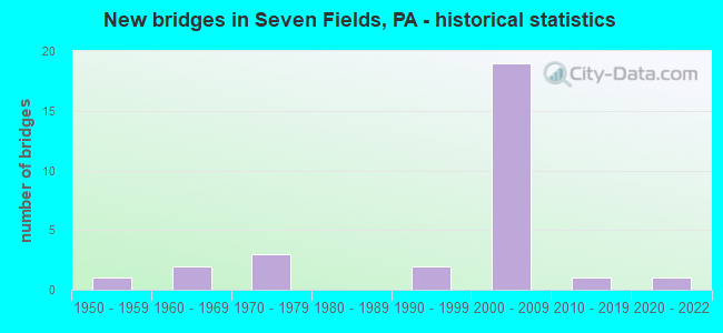
- New bridges - historical statistics
- 11950-1959
- 21960-1969
- 31970-1979
- 21990-1999
- 192000-2009
- 12010-2019
- 12020-2022

- Reconstructed bridges - Historical Statistics
- 21990-1999
- 12000-2009
- 12010-2019


- Bridge Condition - Deck
- 20.0%Excellent
- 10.0%Very good
- 50.0%Good
- 10.0%Satisfactory
- 10.0%Poor

- Bridge Condition - Superstructure
- 20.0%Excellent
- 20.0%Very good
- 50.0%Good
- 10.0%Fair

- Bridge Condition - Substructure
- 20.0%Excellent
- 60.0%Good
- 10.0%Satisfactory
- 10.0%Fair

- Bridge Condition - Channel
- 16.7%Very good
- 33.3%Good
- 16.7%Satisfactory
- 33.3%Fair

- Bridge Condition - Culverts
- 25.0%Good
- 75.0%Satisfactory
Find on map >> Show street view
Structure Number: 7798, Location: DUTIHL (Lat: 40.679444, Lng: -80.100000), Route carried "on" structure: US 19, Year Built: 2004, Status: Open, Structure Length: 0.82m (2.69ft), Average Daily Traffic: 36,438 (year 2022), Truck Traffic: 6%, Average Future Daily Traffic: 53,101 (year 2032), Design Load: HS 20, Features Intersected: PA TURNPIKE RAMP R
Minimum Vertical Clearance: 30+ m (98+ ft), Kilometerpoint: 0.000, Lanes on structure: 2, Lanes under structure: 1, Base Highway Network: Yes, Owner: State Highway Agency, Approaching Roadway Width: 11.6m (38.1ft), Skew: 20 degrees, Material/Design: Concrete, Design/Construction: Culvert, Number Of Spans In Main Unit: 1, Length of Maximum Span: 8.2m (26.9ft)
Condition: Culverts: Good, Inventory Rating: 59.9 metric tons, Method Used To Determine Inventory Rating: Load Factor (LF), Structural Evaluation: Better than present minimum criteria, Underclear: Meets minimum limits, Approach Roadway Alignment: Equal to present desirable criteria, Length Of Structure Improvement: 3.00m (9.84ft), Designated Inspection Frequency: Every 24 months, Inspection Date: September 2021
Find on map >> Show street view
Structure Number: 7853, Location: EPWORTH (Lat: 40.678925, Lng: -80.095714), Route carried "on" structure: Interstate 79, Year Built: 1969, Year Reconstructed: 2004, Status: Open, Structure Length: 0.67m (2.20ft), Average Daily Traffic: 68,330 (year 2021), Truck Traffic: 11%, Average Future Daily Traffic: 58,382 (year 2032), Design Load: HS 20+Mod, Features Intersected: TRIB TO BRUSH CREEK
Minimum Vertical Clearance: 30+ m (98+ ft), Kilometerpoint: 0.000, Lanes on structure: 6, Base Highway Network: Yes, Owner: State Highway Agency, Approaching Roadway Width: 40.2m (131.9ft), Skew: 24 degrees, Material/Design: Concrete, Design/Construction: Culvert, Number Of Spans In Main Unit: 1, Length of Maximum Span: 6.7m (22.0ft)
Condition: Channel: Satisfactory, Culverts: Satisfactory, Operating Rating: 49.0 metric tons, Method Used To Determine Operating Rating: Field evaluation and documented engineering judgment, Inventory Rating: 32.7 metric tons, Method Used To Determine Inventory Rating: Field evaluation and documented engineering judgment, Structural Evaluation: Equal to present minimum criteria, Waterway Adequacy: Superior to present desirable criteria, Approach Roadway Alignment: Equal to present desirable criteria, Length Of Structure Improvement: 1.20m (3.94ft), Designated Inspection Frequency: Every 48 months, Inspection Date: November 2020
Find on map >> Show street view
Structure Number: 8089, Location: OGLE NO.1 (Lat: 40.704031, Lng: -80.101519), Route carried "on" structure: State highway , Year Built: 1970, Year Reconstructed: 2005, Status: Open, Structure Length: 7.99m (26.21ft), Average Daily Traffic: 8,931 (year 2020), Truck Traffic: 3%, Average Future Daily Traffic: 11,721 (year 2032), Design Load: HS 20, Features Intersected: I-79 NB/SB & TR BRUSH CR, Facility Carried by Structure: SR3018
Minimum Vertical Clearance: 30+ m (98+ ft), Kilometerpoint: 0.000, Lanes on structure: 2, Lanes under structure: 4, Owner: State Highway Agency, Approaching Roadway Width: 8.2m (26.9ft), Material/Design: Prestressed concrete, Design/Construction: Stringer/Multi-beam, Number Of Spans In Main Unit: 3, Length of Maximum Span: 30.5m (100.1ft), Curb or Sidewalk Widths: Left: 0.2m (0.7ft), Right: 0.2m (0.7ft), Curb-To-Curb Width: 9.6m (31.5ft), Out-to-Out Width: 10.8m (35.4ft)
Condition: Deck: Poor, Superstructure: Fair, Substructure: Fair, Channel: Good, Operating Rating: 82.6 metric tons, Method Used To Determine Operating Rating: Load Factor (LF), Inventory Rating: 15.4 metric tons, Method Used To Determine Inventory Rating: Load Factor (LF), Structural Evaluation: High priority of corrective action, Deck Geometry: Meets minimum limits, Underclear: High priority of corrective action, Waterway Adequacy: Superior to present desirable criteria, Approach Roadway Alignment: Equal to present desirable criteria, Length Of Structure Improvement: 15.20m (49.87ft), Designated Inspection Frequency: Every 24 months, Inspection Date: July 2020, Bridge Improvement Cost: $113,000, Roadway Improvement Cost: $332,000, Total Project Cost: $1,523,000, Deck Structure Type: Concrete Cast-file-Place, Wearing Surface/Protective System: Wearing Surface: Bituminous
Find on map >> Show street view
Structure Number: 8095, Location: WEST OF OGLE (Lat: 40.699033, Lng: -80.104972), Route carried "on" structure: State highway , Year Built: 1965, Year Reconstructed: 2018, Status: Open, Structure Length: 0.76m (2.49ft), Average Daily Traffic: 17,335 (year 2021), Truck Traffic: 2%, Average Future Daily Traffic: 15,794 (year 2032), Design Load: HS 20, Features Intersected: COAL RUN, Facility Carried by Structure: SR3022
Minimum Vertical Clearance: 30+ m (98+ ft), Kilometerpoint: 2.886, Lanes on structure: 6, Owner: State Highway Agency, Approaching Roadway Width: 18.9m (62.0ft), Material/Design: Concrete, Design/Construction: Slab, Number Of Spans In Main Unit: 1, Length of Maximum Span: 6.7m (22.0ft), Curb-To-Curb Width: 21.9m (71.9ft), Out-to-Out Width: 25.1m (82.3ft)
Condition: Deck: Good, Superstructure: Good, Substructure: Good, Channel: Fair, Operating Rating: 61.7 metric tons, Method Used To Determine Operating Rating: Load Factor (LF), Inventory Rating: 36.3 metric tons, Method Used To Determine Inventory Rating: Load Factor (LF), Structural Evaluation: Better than present minimum criteria, Deck Geometry: High priority of corrective action, Waterway Adequacy: Equal to present desirable criteria, Approach Roadway Alignment: Equal to present desirable criteria, Length Of Structure Improvement: 1.50m (4.92ft), Designated Inspection Frequency: Every 24 months, Inspection Date: October 2020, Bridge Improvement Cost: $21,000, Roadway Improvement Cost: $63,000, Total Project Cost: $287,000, Deck Structure Type: Concrete Cast-file-Place, Wearing Surface/Protective System: Wearing Surface: Bituminous
Find on map >> Show street view
Structure Number: 8152, Location: EAST OF CRANBERRY INTG (Lat: 40.675928, Lng: -80.102617), Route carried "on" structure: Interstate 76, Year Built: 1952, Year Reconstructed: 2001, Status: Open, Structure Length: 0.61m (2.00ft), Average Daily Traffic: 27,341 (year 2001), Truck Traffic: 24%, Average Future Daily Traffic: 39,424 (year 2030), Features Intersected: TRIB. TO BRUSH CREEK
Minimum Vertical Clearance: 30+ m (98+ ft), Kilometerpoint: 0.000, Lanes on structure: 5, Base Highway Network: Yes, Toll: On toll road, Owner: State Toll Authority, Approaching Roadway Width: 42.1m (138.1ft), Skew: 30 degrees, Material/Design: Concrete, Design/Construction: Culvert, Number Of Spans In Main Unit: 1, Length of Maximum Span: 6.1m (20.0ft)
Condition: Channel: Very good, Culverts: Satisfactory, Inventory Rating: 99.8 metric tons, Method Used To Determine Inventory Rating: Load and Resistance Factor (LRFR), Structural Evaluation: Equal to present minimum criteria, Waterway Adequacy: Superior to present desirable criteria, Approach Roadway Alignment: Equal to present desirable criteria, Length Of Structure Improvement: 1.60m (5.25ft), Designated Inspection Frequency: Every 48 months, Inspection Date: May 2018, Bridge Improvement Cost: $45,000, Roadway Improvement Cost: $133,000, Total Project Cost: $610,000
Find on map >> Show street view
Structure Number: 40796, Location: 0.6mi NW of SR3020 (Lat: 40.692814, Lng: -80.111197), Route carried "on" structure: City street , Year Built: 1998, Status: Open, Structure Length: 2.13m (6.99ft), Average Daily Traffic: 2,200 (year 2018), Truck Traffic: 9%, Average Future Daily Traffic: 3,000 (year 2038), Design Load: H 20, Features Intersected: COAL RUN, Facility Carried by Structure: T-936 EXECUTIVE DR
Minimum Vertical Clearance: 30+ m (98+ ft), Kilometerpoint: 0.000, Lanes on structure: 2, Owner: Town or Township Highway Agency, Approaching Roadway Width: 12.5m (41.0ft), Skew: 4 degrees, Material/Design: Prestressed concrete, Design/Construction: Box Beam or Girders - Single/Spread, Number Of Spans In Main Unit: 1, Length of Maximum Span: 20.4m (66.9ft), Curb or Sidewalk Widths: Left: 1.8m (5.9ft), Right: 1.8m (5.9ft), Curb-To-Curb Width: 12.5m (41.0ft), Out-to-Out Width: 16.6m (54.5ft)
Condition: Deck: Satisfactory, Superstructure: Good, Substructure: Satisfactory, Channel: Good, Inventory Rating: 58.1 metric tons, Method Used To Determine Inventory Rating: Load Factor (LF), Structural Evaluation: Equal to present minimum criteria, Deck Geometry: Equal to present minimum criteria, Waterway Adequacy: Equal to present desirable criteria, Approach Roadway Alignment: Better than present minimum criteria, Length Of Structure Improvement: 2.80m (9.19ft), Designated Inspection Frequency: Every 24 months, Inspection Date: Febuary 2020, Deck Structure Type: Concrete Cast-file-Place, Wearing Surface/Protective System: Wearing Surface: Monolithic Concrete, Deck Protection: Epoxy Coated Reinforcing
Find on map >> Show street view
Structure Number: 41062, Location: CRIDERS CORNERS (Lat: 40.685181, Lng: -80.095414), Route carried "on" structure: State highway 228, Year Built: 2000, Status: Open, Structure Length: 10.12m (33.20ft), Average Daily Traffic: 41,296 (year 2021), Truck Traffic: 5%, Average Future Daily Traffic: 51,494 (year 2032), Design Load: HL 93, Features Intersected: I-79 NB&SB & SR9479
Minimum Vertical Clearance: 30+ m (98+ ft), Kilometerpoint: 0.000, Lanes on structure: 7, Lanes under structure: 6, Base Highway Network: Yes, Owner: State Highway Agency, Approaching Roadway Width: 31.7m (104.0ft), Skew: 20 degrees, Material/Design: Prestressed concrete continuous, Design/Construction: Box Beam or Girders - Single/Spread, Number Of Spans In Main Unit: 3, Length of Maximum Span: 34.4m (112.9ft), Curb or Sidewalk Widths: Left: 0.2m (0.7ft), Right: 0.2m (0.7ft), Curb-To-Curb Width: 33.0m (108.3ft), Out-to-Out Width: 33.9m (111.2ft)
Condition: Deck: Good, Superstructure: Good, Substructure: Good, Operating Rating: 69.9 metric tons, Method Used To Determine Operating Rating: Load and Resistance Factor (LRFR), Inventory Rating: 38.1 metric tons, Method Used To Determine Inventory Rating: Load and Resistance Factor (LRFR), Structural Evaluation: Better than present minimum criteria, Deck Geometry: Superior to present desirable criteria, Underclear: Better than present minimum criteria, Approach Roadway Alignment: Equal to present desirable criteria, Length Of Structure Improvement: 10.90m (35.76ft), Designated Inspection Frequency: Every 24 months, Inspection Date: August 2020, Deck Structure Type: Concrete Cast-file-Place, Wearing Surface/Protective System: Wearing Surface: Monolithic Concrete, Deck Protection: Epoxy Coated Reinforcing
Find on map >> Show street view
Structure Number: 41917, Location: 1000 FT EAST OF SR 0019 (Lat: 40.672942, Lng: -80.094989), Route carried "on" structure: State highway , Year Built: 2003, Status: Open, Structure Length: 12.86m (42.19ft), Average Daily Traffic: 4,089 (year 2022), Truck Traffic: 2%, Average Future Daily Traffic: 4,149 (year 2032), Design Load: HS 20, Features Intersected: SR 79 NB-SB TPK RAMPS, Facility Carried by Structure: FREEPORT ROAD
Minimum Vertical Clearance: 30+ m (98+ ft), Kilometerpoint: 0.000, Lanes on structure: 2, Lanes under structure: 7, Owner: State Highway Agency, Approaching Roadway Width: 16.8m (55.1ft), Skew: 4 degrees, Material/Design: Steel continuous, Design/Construction: Stringer/Multi-beam, Number Of Spans In Main Unit: 3, Length of Maximum Span: 48.8m (160.1ft), Curb or Sidewalk Widths: Left: 0.2m (0.7ft), Right: 0.2m (0.7ft), Curb-To-Curb Width: 16.8m (55.1ft), Out-to-Out Width: 17.7m (58.1ft)
Condition: Deck: Good, Superstructure: Very good, Substructure: Good, Operating Rating: 79.8 metric tons, Method Used To Determine Operating Rating: Load Factor (LF), Inventory Rating: 47.2 metric tons, Method Used To Determine Inventory Rating: Load Factor (LF), Structural Evaluation: Better than present minimum criteria, Deck Geometry: Superior to present desirable criteria, Underclear: High priority of corrective action, Approach Roadway Alignment: Equal to present desirable criteria, Length Of Structure Improvement: 12.90m (42.32ft), Designated Inspection Frequency: Every 48 months, Inspection Date: April 2019, Deck Structure Type: Concrete Cast-file-Place, Wearing Surface/Protective System: Wearing Surface: Monolithic Concrete, Deck Protection: Epoxy Coated Reinforcing
Find on map >> Show street view
Structure Number: 42191, Location: TP CONNECTOR OVER I-79 (Lat: 40.677194, Lng: -80.094697), Route carried "on" structure: Ramp State highway , Year Built: 2003, Status: Open, Structure Length: 6.89m (22.60ft), Average Daily Traffic: 10,018 (year 2022), Truck Traffic: 5%, Average Future Daily Traffic: 14,895 (year 2032), Design Load: HS 25 or greater, Features Intersected: I-79 NB&SB & SR9479, Facility Carried by Structure: CONNECTOR (SR8079)
Minimum Vertical Clearance: 30+ m (98+ ft), Kilometerpoint: 0.000, Lanes on structure: 2, Lanes under structure: 6, Base Highway Network: Yes, Owner: State Highway Agency, Approaching Roadway Width: 18.0m (59.1ft), Skew: 31 degrees, Material/Design: Prestressed concrete continuous, Design/Construction: Box Beam or Girders - Single/Spread, Number Of Spans In Main Unit: 2, Length of Maximum Span: 34.4m (112.9ft), Curb or Sidewalk Widths: Left: 0.2m (0.7ft), Right: 0.2m (0.7ft), Curb-To-Curb Width: 17.3m (56.8ft), Out-to-Out Width: 18.9m (62.0ft)
Condition: Deck: Very good, Superstructure: Very good, Substructure: Good, Operating Rating: 68.9 metric tons, Method Used To Determine Operating Rating: Load Factor (LF), Inventory Rating: 36.3 metric tons, Method Used To Determine Inventory Rating: Load Factor (LF), Structural Evaluation: Better than present minimum criteria, Deck Geometry: Superior to present desirable criteria, Underclear: Equal to present minimum criteria, Approach Roadway Alignment: Equal to present desirable criteria, Length Of Structure Improvement: 7.80m (25.59ft), Designated Inspection Frequency: Every 24 months, Inspection Date: June 2020, Deck Structure Type: Concrete Cast-file-Place, Wearing Surface/Protective System: Wearing Surface: Monolithic Concrete, Deck Protection: Epoxy Coated Reinforcing
Find on map >> Show street view
Structure Number: 43344, Location: PERRY HWY. INTERCHANGE (Lat: 40.673333, Lng: -80.103333), Route carried "on" structure: Ramp Interstate 76, Year Built: 2004, Status: Open, Structure Length: 9.94m (32.61ft), Average Daily Traffic: 17,319 (year 1993), Truck Traffic: 15%, Average Future Daily Traffic: 27,626 (year 2030), Design Load: HS 20, Features Intersected: PA TPK (I-76), Facility Carried by Structure: PA TPK RAMP JK
Minimum Vertical Clearance: 30+ m (98+ ft), Kilometerpoint: 0.000, Lanes on structure: 2, Lanes under structure: 4, Base Highway Network: Yes, Toll: On toll road, Owner: State Toll Authority, Approaching Roadway Width: 17.7m (58.1ft), Skew: 32 degrees, Material/Design: Steel continuous, Design/Construction: Stringer/Multi-beam, Number Of Spans In Main Unit: 3, Length of Maximum Span: 30.5m (100.1ft), Curb or Sidewalk Widths: Left: 0.2m (0.7ft), Right: 0.2m (0.7ft), Curb-To-Curb Width: 17.4m (57.1ft), Out-to-Out Width: 21.1m (69.2ft)
Condition: Deck: Good, Superstructure: Good, Substructure: Good, Operating Rating: 98.9 metric tons, Method Used To Determine Operating Rating: Load Factor (LF), Inventory Rating: 59.0 metric tons, Method Used To Determine Inventory Rating: Load Factor (LF), Structural Evaluation: Better than present minimum criteria, Deck Geometry: Superior to present desirable criteria, Underclear: Somewhat better than minimum adequacy, Approach Roadway Alignment: Equal to present desirable criteria, Designated Inspection Frequency: Every 48 months, Inspection Date: May 2018, Deck Structure Type: Concrete Cast-file-Place, Wearing Surface/Protective System: Wearing Surface: Latex Concrete, Deck Protection: Epoxy Coated Reinforcing
Find on map >> Show street view
Structure Number: 43345, Location: CRANBERRY INTERCHANGE (Lat: 40.678056, Lng: -80.099722), Route carried "on" structure: Ramp Interstate 76, Year Built: 2006, Status: Open, Structure Length: 10.24m (33.60ft), Average Daily Traffic: 10,000 (year 2008), Truck Traffic: 15%, Average Future Daily Traffic: 13,880 (year 2030), Features Intersected: SR 0019
Minimum Vertical Clearance: 30+ m (98+ ft), Kilometerpoint: 0.000, Lanes on structure: 4, Lanes under structure: 5, Base Highway Network: Yes, Toll: On toll road, Owner: State Toll Authority, Approaching Roadway Width: 26.2m (86.0ft), Skew: 32 degrees, Material/Design: Steel continuous, Design/Construction: Stringer/Multi-beam, Number Of Spans In Main Unit: 3, Length of Maximum Span: 44.5m (146.0ft), Curb or Sidewalk Widths: Left: 0.2m (0.7ft), Right: 0.2m (0.7ft), Curb-To-Curb Width: 26.4m (86.6ft), Out-to-Out Width: 27.9m (91.5ft)
Condition: Deck: Good, Superstructure: Good, Substructure: Good, Inventory Rating: 65.3 metric tons, Method Used To Determine Inventory Rating: Load Factor (LF), Structural Evaluation: Better than present minimum criteria, Deck Geometry: Superior to present desirable criteria, Underclear: Equal to present minimum criteria, Approach Roadway Alignment: Equal to present desirable criteria, Designated Inspection Frequency: Every 24 months, Inspection Date: May 2020, Deck Structure Type: Concrete Cast-file-Place, Wearing Surface/Protective System: Wearing Surface: Latex Concrete, Deck Protection: Epoxy Coated Reinforcing
Find on map >> Show street view
Structure Number: 47712, Location: 0.7 MI E of SR 3021 (Lat: 40.691525, Lng: -80.063058), Route carried "on" structure: City street , Year Built: 1996, Status: Open, Structure Length: 0.70m (2.30ft), Average Daily Traffic: 100 (year 2015), Average Future Daily Traffic: 110 (year 2035), Design Load: HS 25 or greater, Features Intersected: TRIBUTARY TO KAUFMAN RUN, Facility Carried by Structure: MARS CRIDER ROAD
Minimum Vertical Clearance: 30+ m (98+ ft), Kilometerpoint: 0.000, Lanes on structure: 2, Owner: City or Municipal Highway Agency, Approaching Roadway Width: 8.5m (27.9ft), Material/Design: Concrete, Design/Construction: Culvert, Number Of Spans In Main Unit: 1, Length of Maximum Span: 7.0m (23.0ft)
Condition: Channel: Fair, Culverts: Satisfactory, Operating Rating: 32.7 metric tons, Method Used To Determine Operating Rating: Field evaluation and documented engineering judgment, Inventory Rating: 19.1 metric tons, Method Used To Determine Inventory Rating: Field evaluation and documented engineering judgment, Structural Evaluation: Somewhat better than minimum adequacy, Waterway Adequacy: Better than present minimum criteria, Approach Roadway Alignment: Equal to present desirable criteria, Designated Inspection Frequency: Every 24 months, Inspection Date: March 2021
Find on map >> Show street view
Structure Number: 55776, Location: NORTH BOUNDARY NB (Lat: 40.724044, Lng: -80.101544), Route carried "on" structure: Interstate 79, Year Built: 2020, Status: Open, Structure Length: 1.89m (6.20ft), Average Daily Traffic: 23,543 (year 2022), Truck Traffic: 13%, Average Future Daily Traffic: 25,915 (year 2032), Design Load: HL 93, Features Intersected: TWP. RD. 311 Boundary RD
Minimum Vertical Clearance: 30+ m (98+ ft), Kilometerpoint: 5.108, Lanes on structure: 2, Lanes under structure: 2, Base Highway Network: Yes, Owner: State Highway Agency, Approaching Roadway Width: 12.2m (40.0ft), Skew: 11 degrees, Material/Design: Steel, Design/Construction: Stringer/Multi-beam, Number Of Spans In Main Unit: 1, Length of Maximum Span: 17.7m (58.1ft), Curb or Sidewalk Widths: Left: 0.2m (0.7ft), Right: 0.2m (0.7ft), Curb-To-Curb Width: 18.4m (60.4ft), Out-to-Out Width: 19.4m (63.6ft)
Condition: Deck: Excellent, Superstructure: Excellent, Substructure: Excellent, Operating Rating: 64.5 metric tons, Method Used To Determine Operating Rating: Assigned ratings based on Load and Resistance Factor Design (LRFD) reported by rating factor (RF) using HL93 loadings, Inventory Rating: 49.9 metric tons, Method Used To Determine Inventory Rating: Assigned ratings based on Load and Resistance Factor Design (LRFD) reported by rating factor (RF) using HL93 loadings, Structural Evaluation: Superior to present desirable criteria, Deck Geometry: Superior to present desirable criteria, Underclear: Meets minimum limits, Approach Roadway Alignment: Equal to present desirable criteria, Designated Inspection Frequency: Every 24 months, Inspection Date: December 2020, Deck Structure Type: Concrete Cast-file-Place, Wearing Surface/Protective System: Wearing Surface: Monolithic Concrete, Deck Protection: Epoxy Coated Reinforcing
Find on map >> Show street view
Structure Number: 55777, Location: 2.7 mi N SR 228 Intersect (Lat: 40.723881, Lng: -80.101928), Route carried "on" structure: Interstate 79, Year Built: 2019, Status: Open, Structure Length: 1.89m (6.20ft), Average Daily Traffic: 24,612 (year 2022), Truck Traffic: 13%, Average Future Daily Traffic: 27,804 (year 2032), Design Load: HL 93, Features Intersected: T-311 N Boundary Road
Minimum Vertical Clearance: 30+ m (98+ ft), Kilometerpoint: 5.118, Lanes on structure: 2, Lanes under structure: 2, Base Highway Network: Yes, Owner: State Highway Agency, Approaching Roadway Width: 11.9m (39.0ft), Skew: 11 degrees, Material/Design: Steel, Design/Construction: Stringer/Multi-beam, Number Of Spans In Main Unit: 1, Length of Maximum Span: 17.7m (58.1ft), Curb-To-Curb Width: 18.4m (60.4ft), Out-to-Out Width: 19.4m (63.6ft)
Condition: Deck: Excellent, Superstructure: Excellent, Substructure: Excellent, Operating Rating: 64.5 metric tons, Method Used To Determine Operating Rating: Assigned ratings based on Load and Resistance Factor Design (LRFD) reported by rating factor (RF) using HL93 loadings, Inventory Rating: 49.9 metric tons, Method Used To Determine Inventory Rating: Assigned ratings based on Load and Resistance Factor Design (LRFD) reported by rating factor (RF) using HL93 loadings, Structural Evaluation: Superior to present desirable criteria, Deck Geometry: Superior to present desirable criteria, Underclear: Meets minimum limits, Approach Roadway Alignment: Equal to present desirable criteria, Designated Inspection Frequency: Every 24 months, Inspection Date: November 2019, Deck Structure Type: Concrete Cast-file-Place, Wearing Surface/Protective System: Wearing Surface: Monolithic Concrete, Deck Protection: Epoxy Coated Reinforcing
Find on map >> Show street view
Structure Number: 8089, Location: OGLE NO.1 (Lat: 40.704031, Lng: -80.101519), Route carried "under" structure: Interstate 79, Year Built: 1970, Structure Length: 0. m, Average Daily Traffic: 23,543 (year 2022), Truck Traffic: 13%, Features Intersected: I-79 NB/SB & TR BRUSH CR, Facility Carried by Structure: SR3018
Minimum Vertical Clearance: 5.00m (16.40ft), Kilometerpoint: 2.713, Lanes on structure: 2, Lanes under structure: 2, Material/Design: Prestressed concrete, Design/Construction: Stringer/Multi-beam, Length of Maximum Span: 30.5m (100.1ft)
Find on map >> Show street view
Structure Number: 8089, Location: OGLE NO.1 (Lat: 40.704031, Lng: -80.101519), Route carried "under" structure: Interstate 79, Year Built: 1970, Structure Length: 0. m, Average Daily Traffic: 24,612 (year 2022), Truck Traffic: 13%, Features Intersected: I-79 NB/SB & TR BRUSH CR, Facility Carried by Structure: SR3018
Minimum Vertical Clearance: 5.93m (19.46ft), Kilometerpoint: 2.726, Lanes on structure: 2, Lanes under structure: 2, Material/Design: Prestressed concrete, Design/Construction: Stringer/Multi-beam, Length of Maximum Span: 30.5m (100.1ft)
Find on map >> Show street view
Structure Number: 41062, Location: CRIDERS CORNERS (Lat: 40.685181, Lng: -80.095414), Route carried "under" structure: Ramp State highway , Year Built: 2000, Structure Length: 0. m, Average Daily Traffic: 308 (year 2022), Truck Traffic: 8%, Features Intersected: I-79 NB&SB & SR9479, Facility Carried by Structure: SR 0228 EB & WB
Minimum Vertical Clearance: 5.16m (16.93ft), Kilometerpoint: 0.000, Lanes on structure: 7, Lanes under structure: 1, Material/Design: Prestressed concrete continuous, Design/Construction: Box Beam or Girders - Single/Spread, Length of Maximum Span: 34.4m (112.9ft)
Find on map >> Show street view
Structure Number: 41062, Location: CRIDERS CORNERS (Lat: 40.685181, Lng: -80.095414), Route carried "under" structure: Interstate 79, Year Built: 2000, Structure Length: 0. m, Average Daily Traffic: 23,543 (year 2022), Truck Traffic: 13%, Features Intersected: I-79 NB&SB & SR9479, Facility Carried by Structure: SR 0228 EB & WB
Minimum Vertical Clearance: 5.29m (17.36ft), Kilometerpoint: 1.094, Lanes on structure: 7, Lanes under structure: 3, Material/Design: Prestressed concrete continuous, Design/Construction: Box Beam or Girders - Single/Spread, Length of Maximum Span: 34.4m (112.9ft)
Find on map >> Show street view
Structure Number: 41062, Location: CRIDERS CORNERS (Lat: 40.685181, Lng: -80.095414), Route carried "under" structure: Interstate 79, Year Built: 2000, Structure Length: 0. m, Average Daily Traffic: 33,419 (year 2021), Truck Traffic: 12%, Features Intersected: I-79 NB&SB & SR9479, Facility Carried by Structure: SR 0228 EB & WB
Minimum Vertical Clearance: 5.26m (17.26ft), Kilometerpoint: 1.086, Lanes on structure: 7, Lanes under structure: 2, Material/Design: Prestressed concrete continuous, Design/Construction: Box Beam or Girders - Single/Spread, Length of Maximum Span: 34.4m (112.9ft)
Find on map >> Show street view
Structure Number: 41917, Location: 1000 FT EAST OF SR 0019 (Lat: 40.672942, Lng: -80.094989), Route carried "under" structure: Interstate 79, Year Built: 2003, Structure Length: 0. m, Average Daily Traffic: 30,367 (year 2021), Truck Traffic: 10%, Features Intersected: SR 79 NB-SB TPK RAMPS, Facility Carried by Structure: FREEPORT ROAD
Minimum Vertical Clearance: 6.02m (19.75ft), Kilometerpoint: 44.133, Lanes on structure: 2, Lanes under structure: 2, Material/Design: Steel continuous, Design/Construction: Stringer/Multi-beam, Length of Maximum Span: 48.8m (160.1ft)
Find on map >> Show street view
Structure Number: 41917, Location: 1000 FT EAST OF SR 0019 (Lat: 40.672942, Lng: -80.094989), Route carried "under" structure: Interstate 79, Year Built: 2003, Structure Length: 0. m, Average Daily Traffic: 33,419 (year 2021), Truck Traffic: 12%, Features Intersected: SR 79 NB-SB TPK RAMPS, Facility Carried by Structure: FREEPORT ROAD
Minimum Vertical Clearance: 6.02m (19.75ft), Kilometerpoint: 43.937, Lanes on structure: 2, Lanes under structure: 2, Material/Design: Steel continuous, Design/Construction: Stringer/Multi-beam, Length of Maximum Span: 48.8m (160.1ft)
Find on map >> Show street view
Structure Number: 41917, Location: 1000 FT EAST OF SR 0019 (Lat: 40.672942, Lng: -80.094989), Route carried "under" structure: Ramp State highway , Year Built: 2003, Structure Length: 0. m, Average Daily Traffic: 4,253 (year 2021), Truck Traffic: 7%, Features Intersected: SR 79 NB-SB TPK RAMPS, Facility Carried by Structure: FREEPORT ROAD
Minimum Vertical Clearance: 7.92m (25.98ft), Kilometerpoint: 0.000, Lanes on structure: 2, Lanes under structure: 1, Material/Design: Steel continuous, Design/Construction: Stringer/Multi-beam, Length of Maximum Span: 48.8m (160.1ft)
Find on map >> Show street view
Structure Number: 41917, Location: 1000 FT EAST OF SR 0019 (Lat: 40.672942, Lng: -80.094989), Route carried "under" structure: Ramp State highway , Year Built: 2003, Structure Length: 0. m, Average Daily Traffic: 19,921 (year 2022), Truck Traffic: 25%, Features Intersected: SR 79 NB-SB TPK RAMPS, Facility Carried by Structure: FREEPORT ROAD
Minimum Vertical Clearance: 5.28m (17.32ft), Kilometerpoint: 0.000, Lanes on structure: 2, Lanes under structure: 2, Material/Design: Steel continuous, Design/Construction: Stringer/Multi-beam, Length of Maximum Span: 48.8m (160.1ft)
Find on map >> Show street view
Structure Number: 42191, Location: TP CONNECTOR OVER I-79 (Lat: 40.677194, Lng: -80.094697), Route carried "under" structure: Interstate 79, Year Built: 2003, Structure Length: 0. m, Average Daily Traffic: 30,367 (year 2021), Truck Traffic: 10%, Features Intersected: I-79 NB&SB & SR9479
Minimum Vertical Clearance: 7.11m (23.33ft), Kilometerpoint: 0.000, Lanes on structure: 2, Lanes under structure: 3, Material/Design: Prestressed concrete continuous, Design/Construction: Box Beam or Girders - Single/Spread, Length of Maximum Span: 34.4m (112.9ft)
Find on map >> Show street view
Structure Number: 42191, Location: TP CONNECTOR OVER I-79 (Lat: 40.677194, Lng: -80.094697), Route carried "under" structure: Interstate 79, Year Built: 2003, Structure Length: 0. m, Average Daily Traffic: 33,419 (year 2021), Truck Traffic: 12%, Features Intersected: I-79 NB&SB & SR9479
Minimum Vertical Clearance: 6.11m (20.05ft), Kilometerpoint: 0.000, Lanes on structure: 2, Lanes under structure: 2, Material/Design: Prestressed concrete continuous, Design/Construction: Box Beam or Girders - Single/Spread, Length of Maximum Span: 34.4m (112.9ft)
Find on map >> Show street view
Structure Number: 42191, Location: TP CONNECTOR OVER I-79 (Lat: 40.677194, Lng: -80.094697), Route carried "under" structure: Ramp State highway , Year Built: 2003, Structure Length: 0. m, Average Daily Traffic: 309 (year 2022), Truck Traffic: 8%, Features Intersected: I-79 NB&SB & SR9479, Facility Carried by Structure: CONNECTOR (SR8079)
Minimum Vertical Clearance: 5.34m (17.52ft), Kilometerpoint: 0.000, Lanes on structure: 2, Lanes under structure: 1, Material/Design: Prestressed concrete continuous, Design/Construction: Box Beam or Girders - Single/Spread, Length of Maximum Span: 34.4m (112.9ft)
Find on map >> Show street view
Structure Number: 43344, Location: PERRY HWY. INTERCHANGE (Lat: 40.673333, Lng: -80.103333), Route carried "under" structure: Interstate 76, Year Built: 2004, Structure Length: 0. m, Average Daily Traffic: 27,341 (year 2001), Truck Traffic: 24%, Features Intersected: PA TPK (I-76), Facility Carried by Structure: PA TPK RAMP JK
Minimum Vertical Clearance: 5.21m (17.09ft), Kilometerpoint: 0.000, Lanes on structure: 2, Lanes under structure: 4, Toll: On toll road, Material/Design: Steel continuous, Design/Construction: Stringer/Multi-beam, Length of Maximum Span: 30.5m (100.1ft)
Find on map >> Show street view
Structure Number: 43345, Location: CRANBERRY INTERCHANGE (Lat: 40.678056, Lng: -80.099722), Route carried "under" structure: US 19, Year Built: 2006, Structure Length: 0. m, Average Daily Traffic: 20,107 (year 2022), Truck Traffic: 5%, Features Intersected: SR 0019, Facility Carried by Structure: PA TPK (I-76) RPCD
Minimum Vertical Clearance: 4.78m (15.68ft), Kilometerpoint: 0.000, Lanes on structure: 4, Lanes under structure: 2, Material/Design: Steel continuous, Design/Construction: Stringer/Multi-beam, Length of Maximum Span: 44.5m (146.0ft)
Find on map >> Show street view
Structure Number: 43345, Location: CRANBERRY INTERCHANGE (Lat: 40.678056, Lng: -80.099722), Route carried "under" structure: US 19, Year Built: 2006, Structure Length: 0. m, Average Daily Traffic: 16,331 (year 2022), Truck Traffic: 7%, Features Intersected: SR 0019, Facility Carried by Structure: PA TPK (I-76) RPCD
Minimum Vertical Clearance: 4.79m (15.72ft), Kilometerpoint: 0.000, Lanes on structure: 4, Lanes under structure: 3, Material/Design: Steel continuous, Design/Construction: Stringer/Multi-beam, Length of Maximum Span: 44.5m (146.0ft)