Bridge Statistics for Seven Oaks, South Carolina (SC)
Condition, Traffic, Stress, Structural Evaluation, Project Costs
- National Bridge Inventory (NBI) Statistics
- 21Number of bridges
- 262ft / 80.0mTotal length
- $1,590,000Total costs
- 742,700Total average daily traffic
- 56,817Total average daily truck traffic
- National Bridge Inventory (NBI) Registered Bridges for Seven Oaks
- No street view available for this location
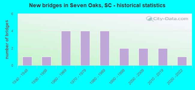
- New bridges - historical statistics
- 11940-1949
- 11950-1959
- 41960-1969
- 41970-1979
- 41980-1989
- 21990-1999
- 22000-2009
- 22010-2019
- 12020-2022

- Reconstructed bridges - Historical Statistics
- 21970-1979
- 21980-1989


- Bridge Condition - Deck
- 6.3%Excellent
- 12.5%Very good
- 56.3%Good
- 18.8%Satisfactory
- 6.3%Fair

- Bridge Condition - Superstructure
- 6.3%Excellent
- 18.8%Very good
- 37.5%Good
- 25.0%Satisfactory
- 12.5%Fair

- Bridge Condition - Substructure
- 6.3%Excellent
- 18.8%Very good
- 37.5%Good
- 31.3%Satisfactory
- 6.3%Poor

- Bridge Condition - Channel
- 7.7%Excellent
- 69.2%Very good
- 23.1%Satisfactory
Find on map >> Show street view
Structure Number: 1631, Location: 4 MI S IRMO (Lat: 34.031117, Lng: -81.161792), Route carried "on" structure: State highway 68, Year Built: 1949, Status: Open, Structure Length: 1.58m (5.18ft), Average Daily Traffic: 10,000 (year 2020), Truck Traffic: 3%, Average Future Daily Traffic: 16,100 (year 2040), Design Load: HS 15, Features Intersected: TWELVE MILE CREEK
Minimum Vertical Clearance: 30+ m (98+ ft), Kilometerpoint: 2.253, Lanes on structure: 2, Owner: State Highway Agency, Approaching Roadway Width: 7.3m (24.0ft), Material/Design: Steel, Design/Construction: Stringer/Multi-beam, Number Of Spans In Main Unit: 1, Length of Maximum Span: 15.8m (51.8ft), Curb-To-Curb Width: 7.3m (24.0ft), Out-to-Out Width: 7.8m (25.6ft)
Condition: Deck: Good, Superstructure: Fair, Substructure: Satisfactory, Channel: Satisfactory, Operating Rating: 37.3 metric tons, Method Used To Determine Operating Rating: Load and Resistance Factor Rating (LRFR) rating reported by rating factor(RF) method using HL-93 loadings, Inventory Rating: 28.8 metric tons, Method Used To Determine Inventory Rating: Load and Resistance Factor Rating (LRFR) rating reported by rating factor(RF) method using HL-93 loadings, Structural Evaluation: Somewhat better than minimum adequacy, Deck Geometry: High priority of replacement, Waterway Adequacy: Better than present minimum criteria, Approach Roadway Alignment: Equal to present desirable criteria, Length Of Structure Improvement: 2.29m (7.51ft), Designated Inspection Frequency: Every 24 months, Inspection Date: October 2020, Bridge Improvement Cost: $173,000, Roadway Improvement Cost: $43,000, Total Project Cost: $260,000 ( Estimate for 2021), Deck Structure Type: Concrete Cast-file-Place, Wearing Surface/Protective System: Wearing Surface: Bituminous
Find on map >> Show street view
Structure Number: 1744, Location: 2 MI S OF IRMO (Lat: 34.059378, Lng: -81.180281), Route carried "on" structure: State highway 174, Year Built: 1950, Status: Posted for load, Structure Length: 2.41m (7.91ft), Average Daily Traffic: 1,650 (year 2021), Truck Traffic: 5%, Average Future Daily Traffic: 2,657 (year 2041), Design Load: H 10, Features Intersected: RR CSXT
Minimum Vertical Clearance: 30+ m (98+ ft), Kilometerpoint: 0.835, Lanes on structure: 2, Owner: State Highway Agency, Approaching Roadway Width: 7.3m (24.0ft), Skew: 1 degrees, Material/Design: Steel, Design/Construction: Stringer/Multi-beam, Number Of Spans In Main Unit: 1, Length of Maximum Span: 24.1m (79.1ft), Curb-To-Curb Width: 7.5m (24.6ft), Out-to-Out Width: 8.4m (27.6ft)
Condition: Deck: Good, Superstructure: Satisfactory, Substructure: Good, Operating Rating: 15.6 metric tons, Method Used To Determine Operating Rating: Load and Resistance Factor Rating (LRFR) rating reported by rating factor(RF) method using HL-93 loadings, Inventory Rating: 12.0 metric tons, Method Used To Determine Inventory Rating: Load and Resistance Factor Rating (LRFR) rating reported by rating factor(RF) method using HL-93 loadings, Structural Evaluation: High priority of replacement, Deck Geometry: Meets minimum limits, Approach Roadway Alignment: Equal to present minimum criteria, Bridge Posting: Required (Relationship of Operating Rating to Maximum Legal Load: > 39.9% below), Length Of Structure Improvement: 3.20m (10.50ft), Designated Inspection Frequency: Every 24 months, Inspection Date: October 2021, Bridge Improvement Cost: $323,000, Roadway Improvement Cost: $81,000, Total Project Cost: $485,000 ( Estimate for 2022), Deck Structure Type: Concrete Cast-file-Place, Wearing Surface/Protective System: Wearing Surface: Bituminous
Find on map >> Show street view
Structure Number: 3374, Location: 6 MI NE OF COLUMBIA (Lat: 34.043611, Lng: -81.118056), Route carried "on" structure: Interstate 26, Year Built: 1960, Year Reconstructed: 1979, Status: Open, Structure Length: 0.64m (2.10ft), Average Daily Traffic: 143,800 (year 2021), Truck Traffic: 9%, Average Future Daily Traffic: 178,312 (year 2041), Design Load: H 20, Features Intersected: STOOP CREEK
Minimum Vertical Clearance: 30+ m (98+ ft), Kilometerpoint: 171.344, Lanes on structure: 8, Base Highway Network: Yes, Owner: State Highway Agency, Approaching Roadway Width: 38.4m (126.0ft), Material/Design: Concrete, Design/Construction: Culvert, Number Of Spans In Main Unit: 2, Length of Maximum Span: 3.0m (9.8ft), Curb-To-Curb Width: 38.4m (126.0ft), Out-to-Out Width: 45.7m (149.9ft)
Condition: Channel: Very good, Culverts: Good, Operating Rating: 58.6 metric tons, Method Used To Determine Operating Rating: Load and Resistance Factor Rating (LRFR) rating reported by rating factor(RF) method using HL-93 loadings, Inventory Rating: 45.4 metric tons, Method Used To Determine Inventory Rating: Load and Resistance Factor Rating (LRFR) rating reported by rating factor(RF) method using HL-93 loadings, Structural Evaluation: Better than present minimum criteria, Deck Geometry: Superior to present desirable criteria, Waterway Adequacy: Superior to present desirable criteria, Approach Roadway Alignment: Equal to present desirable criteria, Length Of Structure Improvement: 0.64m (2.10ft), Designated Inspection Frequency: Every 24 months, Inspection Date: October 2021
Find on map >> Show street view
Structure Number: 3919, Location: 2.5 MI SE IRMO (Lat: 34.058553, Lng: -81.153683), Route carried "on" structure: State highway 671, Year Built: 2008, Status: Open, Structure Length: 2.44m (8.01ft), Average Daily Traffic: 9,400 (year 2020), Truck Traffic: 2%, Average Future Daily Traffic: 12,690 (year 2040), Design Load: HL 93, Features Intersected: KINLEY CREEK
Minimum Vertical Clearance: 30+ m (98+ ft), Kilometerpoint: 0.824, Lanes on structure: 3, Owner: State Highway Agency, Approaching Roadway Width: 12.8m (42.0ft), Material/Design: Concrete continuous, Design/Construction: Slab, Number Of Spans In Main Unit: 2, Length of Maximum Span: 12.2m (40.0ft), Curb or Sidewalk Widths: Left: 1.7m (5.6ft), Right: 1.7m (5.6ft), Curb-To-Curb Width: 12.9m (42.3ft), Out-to-Out Width: 17.2m (56.4ft)
Condition: Deck: Good, Superstructure: Good, Substructure: Good, Channel: Very good, Operating Rating: 67.4 metric tons, Method Used To Determine Operating Rating: Load and Resistance Factor Rating (LRFR) rating reported by rating factor(RF) method using HL-93 loadings, Inventory Rating: 51.8 metric tons, Method Used To Determine Inventory Rating: Load and Resistance Factor Rating (LRFR) rating reported by rating factor(RF) method using HL-93 loadings, Structural Evaluation: Better than present minimum criteria, Deck Geometry: Meets minimum limits, Waterway Adequacy: Equal to present minimum criteria, Approach Roadway Alignment: Equal to present minimum criteria, Length Of Structure Improvement: 2.44m (8.01ft), Designated Inspection Frequency: Every 24 months, Inspection Date: November 2020, Deck Structure Type: Concrete Cast-file-Place, Wearing Surface/Protective System: Wearing Surface: Monolithic Concrete
Find on map >> Show street view
Structure Number: 4366, Location: 5MI NW OF COLUMBIA (Lat: 34.027778, Lng: -81.126111), Route carried "on" structure: Interstate 20, Year Built: 1964, Year Reconstructed: 1991, Status: Open, Structure Length: 5.30m (17.39ft), Average Daily Traffic: 69,200 (year 2020), Truck Traffic: 8%, Average Future Daily Traffic: 85,808 (year 2040), Design Load: HS 20+Mod, Features Intersected: RR CN&L
Minimum Vertical Clearance: 30+ m (98+ ft), Kilometerpoint: 101.379, Lanes on structure: 6, Base Highway Network: Yes, Owner: State Highway Agency, Approaching Roadway Width: 31.1m (102.0ft), Skew: 32 degrees, Material/Design: Prestressed concrete, Design/Construction: Stringer/Multi-beam, Number Of Spans In Main Unit: 3, Length of Maximum Span: 17.7m (58.1ft), Curb-To-Curb Width: 31.3m (102.7ft), Out-to-Out Width: 33.4m (109.6ft)
Condition: Deck: Satisfactory, Superstructure: Satisfactory, Substructure: Good, Operating Rating: 50.9 metric tons, Method Used To Determine Operating Rating: Load and Resistance Factor Rating (LRFR) rating reported by rating factor(RF) method using HL-93 loadings, Inventory Rating: 32.7 metric tons, Method Used To Determine Inventory Rating: Load and Resistance Factor Rating (LRFR) rating reported by rating factor(RF) method using HL-93 loadings, Structural Evaluation: Equal to present minimum criteria, Deck Geometry: Superior to present desirable criteria, Underclear: Somewhat better than minimum adequacy, Approach Roadway Alignment: Better than present minimum criteria, Length Of Structure Improvement: 5.36m (17.59ft), Designated Inspection Frequency: Every 24 months, Inspection Date: November 2021, Deck Structure Type: Concrete Cast-file-Place, Wearing Surface/Protective System: Wearing Surface: Monolithic Concrete
Find on map >> Show street view
Structure Number: 4367, Location: 2 MI SE OF SEVEN OAKS (Lat: 34.035000, Lng: -81.115556), Route carried "on" structure: Interstate 20, Year Built: 1964, Year Reconstructed: 1978, Status: Open, Structure Length: 1.04m (3.41ft), Average Daily Traffic: 69,200 (year 2020), Truck Traffic: 8%, Average Future Daily Traffic: 85,808 (year 2040), Design Load: H 20, Features Intersected: STOOP CREEK
Minimum Vertical Clearance: 30+ m (98+ ft), Kilometerpoint: 101.191, Lanes on structure: 10, Base Highway Network: Yes, Owner: State Highway Agency, Approaching Roadway Width: 41.5m (136.2ft), Skew: 31 degrees, Material/Design: Concrete, Design/Construction: Culvert, Number Of Spans In Main Unit: 3, Length of Maximum Span: 3.0m (9.8ft)
Condition: Channel: Satisfactory, Culverts: Good, Operating Rating: 97.2 metric tons, Method Used To Determine Operating Rating: Load and Resistance Factor Rating (LRFR) rating reported by rating factor(RF) method using HL-93 loadings, Inventory Rating: 97.2 metric tons, Method Used To Determine Inventory Rating: Load and Resistance Factor Rating (LRFR) rating reported by rating factor(RF) method using HL-93 loadings, Structural Evaluation: Better than present minimum criteria, Waterway Adequacy: Equal to present minimum criteria, Approach Roadway Alignment: Equal to present desirable criteria, Length Of Structure Improvement: 1.04m (3.41ft), Designated Inspection Frequency: Every 24 months, Inspection Date: November 2021
Find on map >> Show street view
Structure Number: 4604, Location: 5MI NW OF COLUMBIA (Lat: 34.025600, Lng: -81.128278), Route carried "on" structure: Interstate 20, Year Built: 1965, Year Reconstructed: 1991, Status: Open, Structure Length: 20.03m (65.72ft), Average Daily Traffic: 69,200 (year 2020), Truck Traffic: 8%, Average Future Daily Traffic: 85,808 (year 2040), Design Load: HS 20+Mod, Features Intersected: SALUDA RIVER
Minimum Vertical Clearance: 30+ m (98+ ft), Kilometerpoint: 100.893, Lanes on structure: 6, Base Highway Network: Yes, Owner: State Highway Agency, Approaching Roadway Width: 31.1m (102.0ft), Skew: 32 degrees, Material/Design: Prestressed concrete, Design/Construction: Stringer/Multi-beam, Number Of Spans In Main Unit: 9, Length of Maximum Span: 22.3m (73.2ft), Curb-To-Curb Width: 31.1m (102.0ft), Out-to-Out Width: 32.7m (107.3ft)
Condition: Deck: Good, Superstructure: Good, Substructure: Satisfactory, Channel: Very good, Operating Rating: 41.1 metric tons, Method Used To Determine Operating Rating: Load and Resistance Factor Rating (LRFR) rating reported by rating factor(RF) method using HL-93 loadings, Inventory Rating: 24.9 metric tons, Method Used To Determine Inventory Rating: Load and Resistance Factor Rating (LRFR) rating reported by rating factor(RF) method using HL-93 loadings, Structural Evaluation: Equal to present minimum criteria, Deck Geometry: Superior to present desirable criteria, Waterway Adequacy: Better than present minimum criteria, Approach Roadway Alignment: Equal to present desirable criteria, Length Of Structure Improvement: 20.09m (65.91ft), Designated Inspection Frequency: Every 24 months, Underwater Inspection Frequency: Every 60 months, Inspection Date: November 2021, Underwater Inspection Date: October 2017, Deck Structure Type: Concrete Cast-file-Place, Wearing Surface/Protective System: Wearing Surface: Monolithic Concrete
Find on map >> Show street view
Structure Number: 4611, Location: 5 MI NW OF COLUMBIA (Lat: 34.033925, Lng: -81.115022), Route carried "on" structure: State highway 1241, Year Built: 2012, Status: Open, Structure Length: 1.83m (6.00ft), Average Daily Traffic: 450 (year 2020), Truck Traffic: 5%, Average Future Daily Traffic: 576 (year 2040), Design Load: HL 93, Features Intersected: STOOPS CREEK
Minimum Vertical Clearance: 30+ m (98+ ft), Kilometerpoint: 0.756, Lanes on structure: 2, Owner: State Highway Agency, Approaching Roadway Width: 10.1m (33.1ft), Material/Design: Prestressed concrete, Design/Construction: Slab, Number Of Spans In Main Unit: 1, Length of Maximum Span: 18.3m (60.0ft), Curb-To-Curb Width: 10.1m (33.1ft), Out-to-Out Width: 11.0m (36.1ft)
Condition: Deck: Very good, Superstructure: Very good, Substructure: Very good, Channel: Very good, Operating Rating: 49.6 metric tons, Method Used To Determine Operating Rating: Load and Resistance Factor Rating (LRFR) rating reported by rating factor(RF) method using HL-93 loadings, Inventory Rating: 37.9 metric tons, Method Used To Determine Inventory Rating: Load and Resistance Factor Rating (LRFR) rating reported by rating factor(RF) method using HL-93 loadings, Structural Evaluation: Equal to present desirable criteria, Deck Geometry: Equal to present minimum criteria, Waterway Adequacy: Better than present minimum criteria, Approach Roadway Alignment: Equal to present minimum criteria, Length Of Structure Improvement: 1.83m (6.00ft), Designated Inspection Frequency: Every 24 months, Inspection Date: November 2020, Deck Structure Type: Concrete Precast Panels, Wearing Surface/Protective System: Wearing Surface: Bituminous
Find on map >> Show street view
Structure Number: 5114, Location: 2 MI S IRMO (Lat: 34.053628, Lng: -81.186331), Route carried "on" structure: State highway 107, Year Built: 2007, Status: Open, Structure Length: 3.51m (11.52ft), Average Daily Traffic: 8,400 (year 2020), Truck Traffic: 3%, Average Future Daily Traffic: 11,340 (year 2040), Design Load: HL 93, Features Intersected: RAWLS CREEK
Minimum Vertical Clearance: 30+ m (98+ ft), Kilometerpoint: 3.581, Lanes on structure: 3, Owner: State Highway Agency, Approaching Roadway Width: 12.8m (42.0ft), Material/Design: Prestressed concrete continuous, Design/Construction: Stringer/Multi-beam, Number Of Spans In Main Unit: 3, Length of Maximum Span: 12.2m (40.0ft), Curb or Sidewalk Widths: Left: 1.7m (5.6ft), Right: 1.7m (5.6ft), Curb-To-Curb Width: 12.8m (42.0ft), Out-to-Out Width: 16.5m (54.1ft)
Condition: Deck: Good, Superstructure: Very good, Substructure: Very good, Channel: Very good, Operating Rating: 43.1 metric tons, Method Used To Determine Operating Rating: Load and Resistance Factor Rating (LRFR) rating reported by rating factor(RF) method using HL-93 loadings, Inventory Rating: 33.4 metric tons, Method Used To Determine Inventory Rating: Load and Resistance Factor Rating (LRFR) rating reported by rating factor(RF) method using HL-93 loadings, Structural Evaluation: Equal to present desirable criteria, Deck Geometry: Meets minimum limits, Waterway Adequacy: Better than present minimum criteria, Approach Roadway Alignment: Equal to present desirable criteria, Length Of Structure Improvement: 3.51m (11.52ft), Designated Inspection Frequency: Every 24 months, Inspection Date: October 2020, Deck Structure Type: Concrete Cast-file-Place, Wearing Surface/Protective System: Wearing Surface: Monolithic Concrete
Find on map >> Show street view
Structure Number: 6541, Location: 2MI S OF IRMO (Lat: 34.063889, Lng: -81.184167), Route carried "on" structure: County highway 5606, Year Built: 1974, Status: Posted for load, Structure Length: 0.91m (2.99ft), Average Daily Traffic: 150 (year 2020), Truck Traffic: 5%, Average Future Daily Traffic: 192 (year 2040), Design Load: H 10, Features Intersected: KOON BRANCH
Minimum Vertical Clearance: 30+ m (98+ ft), Kilometerpoint: 0.666, Lanes on structure: 2, Owner: County Highway Agency, Approaching Roadway Width: 8.5m (27.9ft), Material/Design: Concrete, Design/Construction: Slab, Number Of Spans In Main Unit: 2, Length of Maximum Span: 4.6m (15.1ft), Curb-To-Curb Width: 8.0m (26.2ft), Out-to-Out Width: 8.4m (27.6ft)
Condition: Deck: Fair, Superstructure: Fair, Substructure: Poor, Channel: Satisfactory, Operating Rating: 21.4 metric tons, Method Used To Determine Operating Rating: Load and Resistance Factor Rating (LRFR) rating reported by rating factor(RF) method using HL-93 loadings, Inventory Rating: 16.5 metric tons, Method Used To Determine Inventory Rating: Load and Resistance Factor Rating (LRFR) rating reported by rating factor(RF) method using HL-93 loadings, Structural Evaluation: Meets minimum limits, Deck Geometry: Somewhat better than minimum adequacy, Waterway Adequacy: Better than present minimum criteria, Approach Roadway Alignment: Better than present minimum criteria, Bridge Posting: Required (Relationship of Operating Rating to Maximum Legal Load: 20.0 - 29.9% below), Length Of Structure Improvement: 1.55m (5.09ft), Designated Inspection Frequency: Every 12 months, Inspection Date: October 2021, Bridge Improvement Cost: $124,000, Roadway Improvement Cost: $31,000, Total Project Cost: $186,000 ( Estimate for 2021), Deck Structure Type: Concrete Cast-file-Place, Wearing Surface/Protective System: Wearing Surface: Monolithic Concrete
Find on map >> Show street view
Structure Number: 6902, Location: 3 MI SE OF IRMO (Lat: 34.056300, Lng: -81.150833), Route carried "on" structure: State highway 765, Year Built: 1976, Status: Open, Structure Length: 1.37m (4.49ft), Average Daily Traffic: 1,150 (year 2020), Truck Traffic: 2%, Average Future Daily Traffic: 1,852 (year 2040), Design Load: H 10, Features Intersected: RAWLS CREEK
Minimum Vertical Clearance: 30+ m (98+ ft), Kilometerpoint: 1.022, Lanes on structure: 2, Owner: State Highway Agency, Approaching Roadway Width: 9.4m (30.8ft), Material/Design: Steel, Design/Construction: Stringer/Multi-beam, Number Of Spans In Main Unit: 1, Length of Maximum Span: 13.7m (44.9ft), Curb-To-Curb Width: 9.6m (31.5ft), Out-to-Out Width: 10.1m (33.1ft)
Condition: Deck: Good, Superstructure: Satisfactory, Substructure: Good, Channel: Very good, Operating Rating: 6.2 metric tons, Method Used To Determine Operating Rating: Load and Resistance Factor Rating (LRFR) rating reported by rating factor(RF) method using HL-93 loadings, Inventory Rating: 4.9 metric tons, Method Used To Determine Inventory Rating: Load and Resistance Factor Rating (LRFR) rating reported by rating factor(RF) method using HL-93 loadings, Structural Evaluation: High priority of replacement, Deck Geometry: Somewhat better than minimum adequacy, Waterway Adequacy: Better than present minimum criteria, Approach Roadway Alignment: Equal to present desirable criteria, Bridge Posting: Required (Relationship of Operating Rating to Maximum Legal Load: > 39.9% below), Length Of Structure Improvement: 2.06m (6.76ft), Designated Inspection Frequency: Every 24 months, Inspection Date: October 2020, Bridge Improvement Cost: $208,000, Roadway Improvement Cost: $52,000, Total Project Cost: $312,000 ( Estimate for 2021), Deck Structure Type: Concrete Precast Panels, Wearing Surface/Protective System: Wearing Surface: Bituminous
Find on map >> Show street view
Structure Number: 7272, Location: 5 MI NW OF WEST COLUMBIA (Lat: 34.031600, Lng: -81.121383), Route carried "on" structure: State highway 273, Year Built: 1979, Status: Open, Structure Length: 7.59m (24.90ft), Average Daily Traffic: 15,500 (year 2020), Truck Traffic: 2%, Average Future Daily Traffic: 20,925 (year 2040), Design Load: HS 20+Mod, Features Intersected: I-20
Minimum Vertical Clearance: 30+ m (98+ ft), Kilometerpoint: 1.336, Lanes on structure: 6, Lanes under structure: 7, Owner: State Highway Agency, Approaching Roadway Width: 24.1m (79.1ft), Skew: 21 degrees, Material/Design: Steel, Design/Construction: Stringer/Multi-beam, Number Of Spans In Main Unit: 4, Length of Maximum Span: 25.9m (85.0ft), Curb or Sidewalk Widths: Left: 1.8m (5.9ft), Right: 1.8m (5.9ft), Curb-To-Curb Width: 24.1m (79.1ft), Out-to-Out Width: 27.9m (91.5ft)
Condition: Deck: Satisfactory, Superstructure: Satisfactory, Substructure: Satisfactory, Operating Rating: 68.0 metric tons, Method Used To Determine Operating Rating: Load and Resistance Factor Rating (LRFR) rating reported by rating factor(RF) method using HL-93 loadings, Inventory Rating: 52.5 metric tons, Method Used To Determine Inventory Rating: Load and Resistance Factor Rating (LRFR) rating reported by rating factor(RF) method using HL-93 loadings, Structural Evaluation: Equal to present minimum criteria, Deck Geometry: Somewhat better than minimum adequacy, Underclear: Equal to present minimum criteria, Approach Roadway Alignment: Equal to present desirable criteria, Length Of Structure Improvement: 7.59m (24.90ft), Designated Inspection Frequency: Every 24 months, Inspection Date: November 2020, Deck Structure Type: Concrete Cast-file-Place, Wearing Surface/Protective System: Wearing Surface: Monolithic Concrete
Find on map >> Show street view
Structure Number: 7586, Location: 6 MI NW OF COLUMBIA (Lat: 34.044619, Lng: -81.117989), Route carried "on" structure: State highway 36, Year Built: 1982, Status: Open, Structure Length: 10.73m (35.20ft), Average Daily Traffic: 20,000 (year 2020), Truck Traffic: 2%, Average Future Daily Traffic: 27,000 (year 2040), Design Load: HS 20+Mod, Features Intersected: I-26
Minimum Vertical Clearance: 30+ m (98+ ft), Kilometerpoint: 0.105, Lanes on structure: 6, Lanes under structure: 8, Owner: State Highway Agency, Approaching Roadway Width: 25.3m (83.0ft), Skew: 21 degrees, Material/Design: Steel, Design/Construction: Stringer/Multi-beam, Number Of Spans In Main Unit: 4, Length of Maximum Span: 38.4m (126.0ft), Curb or Sidewalk Widths: Left: 1.5m (4.9ft), Right: 1.5m (4.9ft), Curb-To-Curb Width: 25.3m (83.0ft), Out-to-Out Width: 27.7m (90.9ft)
Condition: Deck: Satisfactory, Superstructure: Good, Substructure: Satisfactory, Operating Rating: 32.7 metric tons, Method Used To Determine Operating Rating: Load and Resistance Factor Rating (LRFR) rating reported by rating factor(RF) method using HL-93 loadings, Inventory Rating: 25.3 metric tons, Method Used To Determine Inventory Rating: Load and Resistance Factor Rating (LRFR) rating reported by rating factor(RF) method using HL-93 loadings, Structural Evaluation: Equal to present minimum criteria, Deck Geometry: Somewhat better than minimum adequacy, Underclear: Somewhat better than minimum adequacy, Approach Roadway Alignment: Equal to present desirable criteria, Length Of Structure Improvement: 10.73m (35.20ft), Designated Inspection Frequency: Every 24 months, Inspection Date: November 2020, Deck Structure Type: Concrete Cast-file-Place, Wearing Surface/Protective System: Wearing Surface: Monolithic Concrete
Find on map >> Show street view
Structure Number: 7587, Location: 3.5 MI SE IRMO (Lat: 34.046714, Lng: -81.149411), Route carried "on" structure: State highway 36, Year Built: 1982, Status: Open, Structure Length: 2.74m (8.99ft), Average Daily Traffic: 20,000 (year 2020), Truck Traffic: 2%, Average Future Daily Traffic: 27,000 (year 2040), Design Load: HS 20, Features Intersected: KINLEY CREEK
Minimum Vertical Clearance: 30+ m (98+ ft), Kilometerpoint: 3.117, Lanes on structure: 4, Owner: State Highway Agency, Approaching Roadway Width: 23.2m (76.1ft), Material/Design: Concrete, Design/Construction: Slab, Number Of Spans In Main Unit: 3, Length of Maximum Span: 9.1m (29.9ft), Curb or Sidewalk Widths: Left: 1.5m (4.9ft), Right: 1.5m (4.9ft), Curb-To-Curb Width: 19.5m (64.0ft), Out-to-Out Width: 23.2m (76.1ft)
Condition: Deck: Good, Superstructure: Good, Substructure: Satisfactory, Channel: Very good, Operating Rating: 51.2 metric tons, Method Used To Determine Operating Rating: Load and Resistance Factor Rating (LRFR) rating reported by rating factor(RF) method using HL-93 loadings, Inventory Rating: 39.5 metric tons, Method Used To Determine Inventory Rating: Load and Resistance Factor Rating (LRFR) rating reported by rating factor(RF) method using HL-93 loadings, Structural Evaluation: Equal to present minimum criteria, Deck Geometry: Better than present minimum criteria, Waterway Adequacy: Better than present minimum criteria, Approach Roadway Alignment: Equal to present desirable criteria, Length Of Structure Improvement: 2.74m (8.99ft), Designated Inspection Frequency: Every 24 months, Inspection Date: November 2020, Deck Structure Type: Concrete Cast-file-Place, Wearing Surface/Protective System: Wearing Surface: Monolithic Concrete
Find on map >> Show street view
Structure Number: 7919, Location: 5 MI SE IRMO (Lat: 34.029997, Lng: -81.114444), Route carried "on" structure: State highway 273, Year Built: 1985, Status: Open, Structure Length: 2.74m (8.99ft), Average Daily Traffic: 12,800 (year 2020), Truck Traffic: 3%, Average Future Daily Traffic: 17,280 (year 2040), Design Load: HS 20, Features Intersected: STOOPS CREEK
Minimum Vertical Clearance: 30+ m (98+ ft), Kilometerpoint: 0.674, Lanes on structure: 4, Owner: State Highway Agency, Approaching Roadway Width: 26.2m (86.0ft), Skew: 2 degrees, Material/Design: Concrete, Design/Construction: Slab, Number Of Spans In Main Unit: 3, Length of Maximum Span: 9.1m (29.9ft), Curb or Sidewalk Widths: Left: 1.5m (4.9ft), Right: 1.5m (4.9ft), Curb-To-Curb Width: 19.7m (64.6ft), Out-to-Out Width: 23.2m (76.1ft)
Condition: Deck: Good, Superstructure: Good, Substructure: Good, Channel: Very good, Operating Rating: 86.2 metric tons, Method Used To Determine Operating Rating: Load and Resistance Factor Rating (LRFR) rating reported by rating factor(RF) method using HL-93 loadings, Inventory Rating: 66.7 metric tons, Method Used To Determine Inventory Rating: Load and Resistance Factor Rating (LRFR) rating reported by rating factor(RF) method using HL-93 loadings, Structural Evaluation: Better than present minimum criteria, Deck Geometry: Better than present minimum criteria, Waterway Adequacy: Better than present minimum criteria, Approach Roadway Alignment: Equal to present desirable criteria, Length Of Structure Improvement: 2.74m (8.99ft), Designated Inspection Frequency: Every 24 months, Inspection Date: November 2020, Deck Structure Type: Concrete Cast-file-Place, Wearing Surface/Protective System: Wearing Surface: Monolithic Concrete
Find on map >> Show street view
Structure Number: 8893, Location: 8 MI NW OF COLUMBIA (Lat: 34.067392, Lng: -81.142211), Route carried "on" structure: State highway 671, Year Built: 1995, Status: Open, Structure Length: 8.35m (27.40ft), Average Daily Traffic: 9,400 (year 2020), Truck Traffic: 2%, Average Future Daily Traffic: 12,690 (year 2040), Design Load: HS 20+Mod, Features Intersected: I-26
Minimum Vertical Clearance: 5.41m (17.75ft), Kilometerpoint: 2.335, Lanes on structure: 6, Lanes under structure: 6, Owner: State Highway Agency, Approaching Roadway Width: 23.8m (78.1ft), Skew: 22 degrees, Material/Design: Steel continuous, Design/Construction: Stringer/Multi-beam, Number Of Spans In Main Unit: 2, Number Of Approach Spans: 2, Length of Maximum Span: 29.6m (97.1ft), Curb or Sidewalk Widths: Left: 1.5m (4.9ft), Right: 1.5m (4.9ft), Curb-To-Curb Width: 23.8m (78.1ft), Out-to-Out Width: 27.4m (89.9ft)
Condition: Deck: Good, Superstructure: Good, Substructure: Good, Operating Rating: 35.3 metric tons, Method Used To Determine Operating Rating: Load and Resistance Factor Rating (LRFR) rating reported by rating factor(RF) method using HL-93 loadings, Inventory Rating: 27.2 metric tons, Method Used To Determine Inventory Rating: Load and Resistance Factor Rating (LRFR) rating reported by rating factor(RF) method using HL-93 loadings, Structural Evaluation: Equal to present minimum criteria, Deck Geometry: Somewhat better than minimum adequacy, Underclear: Somewhat better than minimum adequacy, Approach Roadway Alignment: Equal to present minimum criteria, Length Of Structure Improvement: 8.35m (27.40ft), Designated Inspection Frequency: Every 24 months, Inspection Date: November 2020, Deck Structure Type: Concrete Cast-file-Place, Wearing Surface/Protective System: Wearing Surface: Monolithic Concrete
Find on map >> Show street view
Structure Number: 10071, Location: 2 MI S OF IRMO (Lat: 34.056961, Lng: -81.191069), Route carried "on" structure: County highway 356, Year Built: 2015, Status: Open, Structure Length: 4.66m (15.29ft), Average Daily Traffic: 150 (year 2020), Truck Traffic: 5%, Average Future Daily Traffic: 192 (year 2040), Design Load: HL 93, Features Intersected: RAWLS CREEK
Minimum Vertical Clearance: 30+ m (98+ ft), Kilometerpoint: 2.795, Lanes on structure: 2, Owner: County Highway Agency, Approaching Roadway Width: 8.5m (27.9ft), Material/Design: Steel, Design/Construction: Truss - Thru, Number Of Spans In Main Unit: 1, Length of Maximum Span: 45.7m (149.9ft), Curb or Sidewalk Widths: Left: 0.0m, Right: 1.8m (5.9ft), Curb-To-Curb Width: 8.5m (27.9ft), Out-to-Out Width: 9.1m (29.9ft)
Condition: Deck: Very good, Superstructure: Very good, Substructure: Very good, Channel: Very good, Operating Rating: 30.1 metric tons, Method Used To Determine Operating Rating: Load and Resistance Factor Rating (LRFR) rating reported by rating factor(RF) method using HL-93 loadings, Inventory Rating: 23.0 metric tons, Method Used To Determine Inventory Rating: Load and Resistance Factor Rating (LRFR) rating reported by rating factor(RF) method using HL-93 loadings, Structural Evaluation: Equal to present minimum criteria, Deck Geometry: High priority of corrective action, Waterway Adequacy: Better than present minimum criteria, Approach Roadway Alignment: Equal to present desirable criteria, Length Of Structure Improvement: 4.66m (15.29ft), Designated Inspection Frequency: Every 24 months, Critical Feature Inspection Frequency: Every 24 months, Inspection Date: October 2020, Critical Feature Inspection Date: October 2020, Deck Structure Type: Concrete Cast-file-Place, Wearing Surface/Protective System: Wearing Surface: Monolithic Concrete
Find on map >> Show street view
Structure Number: 10698, Location: 2 MI S OF IRMO (Lat: 34.060556, Lng: -81.185556), Route carried "on" structure: County highway 5610, Year Built: 2021, Status: Open, Structure Length: 2.13m (6.99ft), Average Daily Traffic: 150 (year 2021), Truck Traffic: 5%, Average Future Daily Traffic: 192 (year 2041), Design Load: HL 93, Features Intersected: KOON BRANCH
Minimum Vertical Clearance: 30+ m (98+ ft), Kilometerpoint: 0.755, Lanes on structure: 2, Owner: County Highway Agency, Approaching Roadway Width: 8.2m (26.9ft), Material/Design: Prestressed concrete, Design/Construction: Slab, Number Of Spans In Main Unit: 1, Length of Maximum Span: 21.3m (69.9ft), Curb-To-Curb Width: 8.2m (26.9ft), Out-to-Out Width: 9.1m (29.9ft)
Condition: Deck: Excellent, Superstructure: Excellent, Substructure: Excellent, Channel: Excellent, Operating Rating: 71.9 metric tons, Method Used To Determine Operating Rating: Load and Resistance Factor Rating (LRFR) rating reported by rating factor(RF) method using HL-93 loadings, Inventory Rating: 71.9 metric tons, Method Used To Determine Inventory Rating: Load and Resistance Factor Rating (LRFR) rating reported by rating factor(RF) method using HL-93 loadings, Structural Evaluation: Superior to present desirable criteria, Deck Geometry: Somewhat better than minimum adequacy, Waterway Adequacy: Better than present minimum criteria, Approach Roadway Alignment: Better than present minimum criteria, Bridge Posting: Required (Relationship of Operating Rating to Maximum Legal Load: > 39.9% below), Length Of Structure Improvement: 2.90m (9.51ft), Designated Inspection Frequency: Every 24 months, Other Special Inspection Frequency: Every 12 months, Inspection Date: October 2021, Other Special Inspection Date: December 2021, Bridge Improvement Cost: $231,000, Roadway Improvement Cost: $58,000, Total Project Cost: $347,000 ( Estimate for 2022), Deck Structure Type: Concrete Precast Panels, Wearing Surface/Protective System: Wearing Surface: Bituminous
Find on map >> Show street view
Structure Number: 7272, Location: 5 MI NW OF WEST COLUMBIA (Lat: 34.031600, Lng: -81.121383), Route carried "under" structure: Interstate 20, Year Built: 1979, Structure Length: 0. m, Average Daily Traffic: 69,200 (year 2020), Truck Traffic: 8%, Features Intersected: I-20, Facility Carried by Structure: S-32-273
Minimum Vertical Clearance: 5.36m (17.59ft), Kilometerpoint: 102.016, Lanes on structure: 6, Lanes under structure: 7, Material/Design: Steel, Design/Construction: Stringer/Multi-beam, Length of Maximum Span: 25.9m (85.0ft)
Find on map >> Show street view
Structure Number: 7586, Location: 6 MI NW OF COLUMBIA (Lat: 34.044619, Lng: -81.117989), Route carried "under" structure: Interstate 26, Year Built: 1982, Structure Length: 0. m, Average Daily Traffic: 112,400 (year 2020), Truck Traffic: 9%, Features Intersected: I-26, Facility Carried by Structure: S-32-36
Minimum Vertical Clearance: 5.23m (17.16ft), Kilometerpoint: 171.331, Lanes on structure: 6, Lanes under structure: 8, Material/Design: Steel, Design/Construction: Stringer/Multi-beam, Length of Maximum Span: 38.4m (126.0ft)
Find on map >> Show street view
Structure Number: 8893, Location: 8 MI NW OF COLUMBIA (Lat: 34.067392, Lng: -81.142211), Route carried "under" structure: Interstate 26, Year Built: 1995, Structure Length: 0. m, Average Daily Traffic: 100,500 (year 2020), Truck Traffic: 9%, Features Intersected: I-26, Facility Carried by Structure: S-32-671
Minimum Vertical Clearance: 5.41m (17.75ft), Kilometerpoint: 167.935, Lanes on structure: 6, Lanes under structure: 6, Material/Design: Steel continuous, Design/Construction: Stringer/Multi-beam, Length of Maximum Span: 29.6m (97.1ft)