Bridge Statistics for Severy, Kansas (KS)
Condition, Traffic, Stress, Structural Evaluation, Project Costs
- National Bridge Inventory (NBI) Statistics
- 21Number of bridges
- 98ft / 30.3mTotal length
- $150,000Total costs
- 15,735Total average daily traffic
- 4,498Total average daily truck traffic
- 24,125Total future (year 2040) average daily traffic
- National Bridge Inventory (NBI) Registered Bridges for Severy
- No street view available for this location
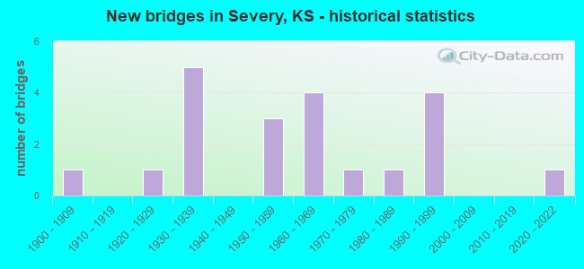
- New bridges - historical statistics
- 11900-1909
- 11920-1929
- 51930-1939
- 31950-1959
- 41960-1969
- 11970-1979
- 11980-1989
- 41990-1999
- 12020-2022


- Bridge Condition - Deck
- 11.1%Very good
- 22.2%Good
- 55.6%Satisfactory
- 11.1%Fair

- Bridge Condition - Superstructure
- 22.2%Very good
- 11.1%Good
- 55.6%Satisfactory
- 11.1%Fair

- Bridge Condition - Substructure
- 22.2%Very good
- 11.1%Good
- 44.4%Satisfactory
- 22.2%Fair

- Bridge Condition - Channel
- 47.6%Good
- 28.6%Satisfactory
- 19.0%Fair
- 4.8%Poor

- Bridge Condition - Culverts
- 8.3%Very good
- 41.7%Good
- 33.3%Satisfactory
- 8.3%Fair
- 8.3%Serious
Find on map >> Show street view
Structure Number: 25047, Location: 9.0N 2.5E OF HOWARD (Lat: 37.602744, Lng: -96.215742), Route carried "on" structure: County highway 1578, Year Built: 1978, Status: Open, Structure Length: 4.34m (14.24ft), Average Daily Traffic: 81 (year 2016), Truck Traffic: 10%, Average Future Daily Traffic: 97 (year 2040), Design Load: H 20, Features Intersected: SALT CREEK, Facility Carried by Structure: Road 18
Minimum Vertical Clearance: 30.47m (99.97ft), Kilometerpoint: 0.000, Lanes on structure: 2, Owner: County Highway Agency, Approaching Roadway Width: 9.1m (29.9ft), Material/Design: Concrete continuous, Design/Construction: Slab, Number Of Spans In Main Unit: 3, Length of Maximum Span: 17.1m (56.1ft), Curb-To-Curb Width: 8.5m (27.9ft), Out-to-Out Width: 9.1m (29.9ft)
Condition: Deck: Good, Superstructure: Good, Substructure: Satisfactory, Channel: Satisfactory, Operating Rating: 43.1 metric tons, Method Used To Determine Operating Rating: Load Factor (LF), Inventory Rating: 25.9 metric tons, Method Used To Determine Inventory Rating: Load Factor (LF), Structural Evaluation: Equal to present minimum criteria, Deck Geometry: Better than present minimum criteria, Waterway Adequacy: Equal to present desirable criteria, Approach Roadway Alignment: Equal to present desirable criteria, Designated Inspection Frequency: Every 24 months, Inspection Date: July 2020, Deck Structure Type: Concrete Cast-file-Place
Find on map >> Show street view
Structure Number: 25048, Location: 9.0N 2.5E OF HOWARD (Lat: 37.598764, Lng: -96.215675), Route carried "on" structure: County highway 1578, Year Built: 1952, Status: Open, Structure Length: 0.75m (2.46ft), Average Daily Traffic: 81 (year 2016), Truck Traffic: 10%, Average Future Daily Traffic: 97 (year 2040), Features Intersected: TRIB. TO SALT CREEK, Facility Carried by Structure: Road 18
Minimum Vertical Clearance: 30.47m (99.97ft), Kilometerpoint: 0.000, Lanes on structure: 2, Owner: County Highway Agency, Approaching Roadway Width: 10.9m (35.8ft), Skew: 3 degrees, Material/Design: Concrete continuous, Design/Construction: Slab, Number Of Spans In Main Unit: 2, Length of Maximum Span: 3.7m (12.1ft), Curb-To-Curb Width: 7.9m (25.9ft), Out-to-Out Width: 8.5m (27.9ft)
Condition: Deck: Satisfactory, Superstructure: Satisfactory, Substructure: Good, Channel: Fair, Operating Rating: 38.7 metric tons, Method Used To Determine Operating Rating: Load Factor (LF), Inventory Rating: 23.4 metric tons, Method Used To Determine Inventory Rating: Load Factor (LF), Structural Evaluation: Equal to present minimum criteria, Deck Geometry: Equal to present minimum criteria, Waterway Adequacy: Equal to present minimum criteria, Approach Roadway Alignment: Equal to present desirable criteria, Designated Inspection Frequency: Every 24 months, Inspection Date: July 2020, Deck Structure Type: Concrete Cast-file-Place, Wearing Surface/Protective System: Wearing Surface: Gravel
Find on map >> Show street view
Structure Number: 25049, Location: 8.5N 2.6E OF HOWARD (Lat: 37.591528, Lng: -96.212250), Route carried "on" structure: County highway 1578, Year Built: 1953, Status: Open, Structure Length: 1.23m (4.04ft), Average Daily Traffic: 81 (year 2016), Truck Traffic: 10%, Average Future Daily Traffic: 97 (year 2040), Features Intersected: TRIB. TO SALT CREEK, Facility Carried by Structure: Turkey
Minimum Vertical Clearance: 30.47m (99.97ft), Kilometerpoint: 0.000, Lanes on structure: 2, Owner: County Highway Agency, Approaching Roadway Width: 9.7m (31.8ft), Material/Design: Concrete, Design/Construction: Culvert, Number Of Spans In Main Unit: 4, Length of Maximum Span: 3.0m (9.8ft), Curb-To-Curb Width: 8.0m (26.2ft), Out-to-Out Width: 8.6m (28.2ft)
Condition: Channel: Good, Culverts: Satisfactory, Operating Rating: 38.7 metric tons, Method Used To Determine Operating Rating: Load Factor (LF), Inventory Rating: 23.4 metric tons, Method Used To Determine Inventory Rating: Load Factor (LF), Structural Evaluation: Equal to present minimum criteria, Deck Geometry: Equal to present minimum criteria, Waterway Adequacy: Better than present minimum criteria, Approach Roadway Alignment: Equal to present desirable criteria, Designated Inspection Frequency: Every 24 months, Inspection Date: July 2020, Wearing Surface/Protective System: Wearing Surface: Gravel
Find on map >> Show street view
Structure Number: 370415, Location: 3.0W OF SEVERY (Lat: 37.618833, Lng: -96.289500), Route carried "on" structure: County highway 780, Year Built: 1920, Status: Posted for load, Structure Length: 0.67m (2.20ft), Average Daily Traffic: 16 (year 2006), Average Future Daily Traffic: 16 (year 2043), Design Load: HS 20, Features Intersected: SALT CREEK
Minimum Vertical Clearance: 30.47m (99.97ft), Kilometerpoint: 0.000, Lanes on structure: 2, Owner: County Highway Agency, Approaching Roadway Width: 3.6m (11.8ft), Material/Design: Concrete, Design/Construction: Culvert, Number Of Spans In Main Unit: 1, Length of Maximum Span: 6.1m (20.0ft), Curb or Sidewalk Widths: Left: 0.1m (0.3ft), Right: 0.1m (0.3ft), Curb-To-Curb Width: 7.3m (24.0ft), Out-to-Out Width: 7.5m (24.6ft)
Condition: Channel: Poor, Culverts: Serious, Operating Rating: 28.8 metric tons, Method Used To Determine Operating Rating: Load Factor (LF), Inventory Rating: 21.6 metric tons, Method Used To Determine Inventory Rating: Load Factor (LF), Structural Evaluation: High priority of corrective action, Deck Geometry: Equal to present minimum criteria, Waterway Adequacy: Equal to present minimum criteria, Approach Roadway Alignment: Equal to present desirable criteria, Length Of Structure Improvement: 6.07m (19.91ft), Designated Inspection Frequency: Every 12 months, Inspection Date: June 2021, Bridge Improvement Cost: $33,000, Roadway Improvement Cost: $20,000, Total Project Cost: $61,000, Wearing Surface/Protective System: Wearing Surface: Gravel
Find on map >> Show street view
Structure Number: 250941006347, Location: 6.1N 2.7E OF HOWARD (Lat: 37.565836, Lng: -96.215592), Route carried "on" structure: County highway 2505, Year Built: 2020, Status: Open, Structure Length: 1.54m (5.05ft), Average Daily Traffic: 10 (year 2018), Truck Traffic: 5%, Average Future Daily Traffic: 12 (year 2041), Design Load: HL 93, Features Intersected: TRIB. TO SALT CREEK, Facility Carried by Structure: 18-C.9 MINOR
Minimum Vertical Clearance: 30.47m (99.97ft), Kilometerpoint: 0.000, Lanes on structure: 2, Owner: County Highway Agency, Approaching Roadway Width: 6.7m (22.0ft), Skew: 4 degrees, Material/Design: Concrete, Design/Construction: Stringer/Multi-beam, Number Of Spans In Main Unit: 1, Length of Maximum Span: 14.9m (48.9ft), Curb or Sidewalk Widths: Left: 0.1m (0.3ft), Right: 0.1m (0.3ft), Curb-To-Curb Width: 7.6m (24.9ft), Out-to-Out Width: 7.8m (25.6ft)
Condition: Deck: Very good, Superstructure: Very good, Substructure: Very good, Channel: Good, Operating Rating: 61.0 metric tons, Method Used To Determine Operating Rating: Load and Resistance Factor (LRFR), Inventory Rating: 47.0 metric tons, Method Used To Determine Inventory Rating: Load and Resistance Factor (LRFR), Structural Evaluation: Equal to present desirable criteria, Deck Geometry: Equal to present minimum criteria, Waterway Adequacy: Equal to present minimum criteria, Approach Roadway Alignment: Equal to present desirable criteria, Designated Inspection Frequency: Every 24 months, Inspection Date: July 2021, Deck Structure Type: Concrete Precast Panels
Find on map >> Show street view
Structure Number: 370935006261, Location: 2.0W OF SEVERY (Lat: 37.634806, Lng: -96.271278), Route carried "on" structure: County highway , Year Built: 1900, Status: Posted for load, Structure Length: 1.05m (3.44ft), Average Daily Traffic: 30 (year 2006), Average Future Daily Traffic: 30 (year 2043), Design Load: HS 20, Features Intersected: SALT CREEK, Facility Carried by Structure: CTY RD Q (O-38.1)
Minimum Vertical Clearance: 30.47m (99.97ft), Kilometerpoint: 0.000, Lanes on structure: 2, Owner: County Highway Agency, Approaching Roadway Width: 7.3m (24.0ft), Material/Design: Concrete continuous, Design/Construction: Slab, Number Of Spans In Main Unit: 3, Length of Maximum Span: 3.0m (9.8ft), Curb or Sidewalk Widths: Left: 0.1m (0.3ft), Right: 0.1m (0.3ft), Curb-To-Curb Width: 7.6m (24.9ft), Out-to-Out Width: 7.8m (25.6ft)
Condition: Deck: Satisfactory, Superstructure: Satisfactory, Substructure: Satisfactory, Channel: Satisfactory, Operating Rating: 28.8 metric tons, Method Used To Determine Operating Rating: Load Factor (LF), Inventory Rating: 21.6 metric tons, Method Used To Determine Inventory Rating: Load Factor (LF), Structural Evaluation: Equal to present minimum criteria, Deck Geometry: Equal to present minimum criteria, Waterway Adequacy: Somewhat better than minimum adequacy, Approach Roadway Alignment: Better than present minimum criteria, Designated Inspection Frequency: Every 24 months, Inspection Date: June 2021, Deck Structure Type: Other, Wearing Surface/Protective System: Wearing Surface: Gravel
Find on map >> Show street view
Structure Number: 37093580628, Location: 1.2W OF SEVERY (Lat: 37.620750, Lng: -96.258083), Route carried "on" structure: County highway , Year Built: 1966, Status: Posted for load, Structure Length: 2.27m (7.45ft), Average Daily Traffic: 37 (year 2006), Average Future Daily Traffic: 37 (year 2043), Design Load: HS 20, Features Intersected: SALT CREEK, Facility Carried by Structure: CTY RD 10 (39-O.8)
Minimum Vertical Clearance: 30.47m (99.97ft), Kilometerpoint: 0.000, Lanes on structure: 2, Owner: County Highway Agency, Approaching Roadway Width: 7.3m (24.0ft), Material/Design: Concrete, Design/Construction: Culvert, Number Of Spans In Main Unit: 5, Length of Maximum Span: 2.4m (7.9ft), Curb or Sidewalk Widths: Left: 0.2m (0.7ft), Right: 0.2m (0.7ft), Curb-To-Curb Width: 8.0m (26.2ft), Out-to-Out Width: 8.5m (27.9ft)
Condition: Channel: Satisfactory, Culverts: Fair, Operating Rating: 44.1 metric tons, Method Used To Determine Operating Rating: Load Factor (LF), Inventory Rating: 32.4 metric tons, Method Used To Determine Inventory Rating: Load Factor (LF), Structural Evaluation: Somewhat better than minimum adequacy, Deck Geometry: Equal to present minimum criteria, Waterway Adequacy: Equal to present minimum criteria, Approach Roadway Alignment: Equal to present desirable criteria, Designated Inspection Frequency: Every 24 months, Inspection Date: June 2021, Wearing Surface/Protective System: Wearing Surface: Gravel
Find on map >> Show street view
Structure Number: 37093590628, Location: 1.1W OF SEVERY (Lat: 37.620472, Lng: -96.252831), Route carried "on" structure: County highway , Year Built: 1965, Status: Posted for load, Structure Length: 0.91m (2.99ft), Average Daily Traffic: 37 (year 2006), Average Future Daily Traffic: 37 (year 2043), Design Load: HS 20, Features Intersected: TRIB. TO SALT CREEK, Facility Carried by Structure: CTY RD 10 (39-O.9)
Minimum Vertical Clearance: 30.47m (99.97ft), Kilometerpoint: 0.000, Lanes on structure: 2, Owner: County Highway Agency, Approaching Roadway Width: 7.8m (25.6ft), Skew: 3 degrees, Material/Design: Concrete, Design/Construction: Culvert, Number Of Spans In Main Unit: 3, Length of Maximum Span: 2.4m (7.9ft), Curb or Sidewalk Widths: Left: 0.2m (0.7ft), Right: 0.2m (0.7ft), Curb-To-Curb Width: 7.9m (25.9ft), Out-to-Out Width: 8.4m (27.6ft)
Condition: Channel: Satisfactory, Culverts: Satisfactory, Operating Rating: 44.1 metric tons, Method Used To Determine Operating Rating: Load Factor (LF), Inventory Rating: 32.4 metric tons, Method Used To Determine Inventory Rating: Load Factor (LF), Structural Evaluation: Equal to present minimum criteria, Deck Geometry: Equal to present minimum criteria, Waterway Adequacy: Equal to present minimum criteria, Approach Roadway Alignment: Better than present minimum criteria, Designated Inspection Frequency: Every 24 months, Inspection Date: June 2021, Wearing Surface/Protective System: Wearing Surface: Gravel
Find on map >> Show street view
Structure Number: 370939006285, Location: 0.5S of Severy (Lat: 37.613444, Lng: -96.233889), Route carried "on" structure: County highway , Year Built: 1965, Status: Open, Structure Length: 1.08m (3.54ft), Average Daily Traffic: 38 (year 2006), Average Future Daily Traffic: 38 (year 2043), Features Intersected: Salt Creek, Facility Carried by Structure: County Rd. S
Minimum Vertical Clearance: 30.47m (99.97ft), Kilometerpoint: 0.000, Lanes on structure: 2, Owner: County Highway Agency, Approaching Roadway Width: 6.4m (21.0ft), Material/Design: Steel, Design/Construction: Stringer/Multi-beam, Number Of Spans In Main Unit: 1, Length of Maximum Span: 9.8m (32.2ft), Curb or Sidewalk Widths: Left: 0.2m (0.7ft), Right: 0.2m (0.7ft), Curb-To-Curb Width: 7.4m (24.3ft), Out-to-Out Width: 7.9m (25.9ft)
Condition: Deck: Satisfactory, Superstructure: Satisfactory, Substructure: Fair, Channel: Fair, Operating Rating: 27.4 metric tons, Method Used To Determine Operating Rating: Load Factor (LF), Inventory Rating: 16.3 metric tons, Method Used To Determine Inventory Rating: Load Factor (LF), Structural Evaluation: Somewhat better than minimum adequacy, Deck Geometry: Equal to present minimum criteria, Waterway Adequacy: Equal to present minimum criteria, Approach Roadway Alignment: Better than present minimum criteria, Designated Inspection Frequency: Every 24 months, Inspection Date: June 2021, Deck Structure Type: Concrete Cast-file-Place, Wearing Surface/Protective System: Wearing Surface: Gravel
Find on map >> Show street view
Structure Number: 370939906265, Location: EAST EDGE OF SEVERY (Lat: 37.628028, Lng: -96.218056), Route carried "on" structure: County highway , Year Built: 1957, Status: Posted for load, Structure Length: 1.65m (5.41ft), Average Daily Traffic: 85 (year 2006), Average Future Daily Traffic: 85 (year 2043), Features Intersected: TRIB. TO SALT CREEK, Facility Carried by Structure: RD 15 (38.5-Q.9)
Minimum Vertical Clearance: 30.47m (99.97ft), Kilometerpoint: 0.000, Lanes on structure: 2, Owner: County Highway Agency, Approaching Roadway Width: 3.0m (9.8ft), Material/Design: Steel, Design/Construction: Stringer/Multi-beam, Number Of Spans In Main Unit: 1, Length of Maximum Span: 15.2m (49.9ft), Curb or Sidewalk Widths: Left: 0.3m (1.0ft), Right: 0.3m (1.0ft), Curb-To-Curb Width: 7.4m (24.3ft), Out-to-Out Width: 8.0m (26.2ft)
Condition: Deck: Satisfactory, Superstructure: Satisfactory, Substructure: Satisfactory, Channel: Fair, Operating Rating: 23.0 metric tons, Method Used To Determine Operating Rating: Load Factor (LF), Inventory Rating: 13.8 metric tons, Method Used To Determine Inventory Rating: Load Factor (LF), Structural Evaluation: Meets minimum limits, Deck Geometry: Equal to present minimum criteria, Waterway Adequacy: Equal to present minimum criteria, Approach Roadway Alignment: Equal to present desirable criteria, Bridge Posting: Required (Relationship of Operating Rating to Maximum Legal Load: > 39.9% below), Designated Inspection Frequency: Every 24 months, Inspection Date: June 2021, Deck Structure Type: Concrete Cast-file-Place, Wearing Surface/Protective System: Wearing Surface: Bituminous
Find on map >> Show street view
Structure Number: 37094110628, Location: 1.0E of Severy (Lat: 37.620667, Lng: -96.213639), Route carried "on" structure: County highway 3702, Year Built: 1936, Year Reconstructed: 1977, Status: Posted for load, Structure Length: 1.58m (5.18ft), Average Daily Traffic: 72 (year 2006), Average Future Daily Traffic: 72 (year 2043), Design Load: HS 20, Features Intersected: Trib. to Salt Creek, Facility Carried by Structure: County Rd. 10
Minimum Vertical Clearance: 30.47m (99.97ft), Kilometerpoint: 0.000, Lanes on structure: 2, Owner: County Highway Agency, Approaching Roadway Width: 6.0m (19.7ft), Material/Design: Concrete continuous, Design/Construction: Slab, Number Of Spans In Main Unit: 3, Length of Maximum Span: 4.3m (14.1ft), Curb or Sidewalk Widths: Left: 0.3m (1.0ft), Right: 0.3m (1.0ft), Curb-To-Curb Width: 6.1m (20.0ft), Out-to-Out Width: 6.7m (22.0ft)
Condition: Deck: Fair, Superstructure: Fair, Substructure: Fair, Channel: Fair, Operating Rating: 28.8 metric tons, Method Used To Determine Operating Rating: Load Factor (LF), Inventory Rating: 21.6 metric tons, Method Used To Determine Inventory Rating: Load Factor (LF), Structural Evaluation: Somewhat better than minimum adequacy, Deck Geometry: Somewhat better than minimum adequacy, Waterway Adequacy: Equal to present minimum criteria, Approach Roadway Alignment: Equal to present desirable criteria, Length Of Structure Improvement: 7.77m (25.49ft), Designated Inspection Frequency: Every 24 months, Inspection Date: June 2021, Bridge Improvement Cost: $52,000, Roadway Improvement Cost: $26,000, Total Project Cost: $89,000, Deck Structure Type: Other, Wearing Surface/Protective System: Wearing Surface: Gravel
Find on map >> Show street view
Structure Number: 370943006206, Location: 10.6S 6.0E OF EUREKA (Lat: 37.670472, Lng: -96.197389), Route carried "on" structure: County highway , Year Built: 1932, Status: Posted for load, Structure Length: 1.02m (3.35ft), Average Daily Traffic: 31 (year 2006), Average Future Daily Traffic: 31 (year 2043), Design Load: HS 20, Features Intersected: TRIB. TO FALL RIVER, Facility Carried by Structure: CTY RD U (S-35.6)
Minimum Vertical Clearance: 30.47m (99.97ft), Kilometerpoint: 0.000, Lanes on structure: 2, Owner: County Highway Agency, Approaching Roadway Width: 7.3m (24.0ft), Material/Design: Concrete, Design/Construction: Culvert, Number Of Spans In Main Unit: 3, Length of Maximum Span: 3.0m (9.8ft), Curb or Sidewalk Widths: Left: 0.4m (1.3ft), Right: 0.4m (1.3ft), Curb-To-Curb Width: 7.9m (25.9ft), Out-to-Out Width: 8.7m (28.5ft)
Condition: Channel: Satisfactory, Culverts: Satisfactory, Operating Rating: 44.1 metric tons, Method Used To Determine Operating Rating: Load Factor (LF), Inventory Rating: 32.4 metric tons, Method Used To Determine Inventory Rating: Load Factor (LF), Structural Evaluation: Equal to present minimum criteria, Deck Geometry: Equal to present minimum criteria, Waterway Adequacy: Somewhat better than minimum adequacy, Approach Roadway Alignment: Equal to present desirable criteria, Designated Inspection Frequency: Every 24 months, Inspection Date: June 2021, Wearing Surface/Protective System: Wearing Surface: Gravel
Find on map >> Show street view
Structure Number: 370943006207, Location: 10.7S 6.0E OF EUREKA (Lat: 37.668389, Lng: -96.197500), Route carried "on" structure: County highway , Year Built: 1932, Status: Posted for load, Structure Length: 1.04m (3.41ft), Average Daily Traffic: 31 (year 2006), Average Future Daily Traffic: 31 (year 2043), Design Load: HS 20, Features Intersected: TRIB. TO FALL RIVER, Facility Carried by Structure: CTY RD U (S-35.7)
Minimum Vertical Clearance: 30.47m (99.97ft), Kilometerpoint: 0.000, Lanes on structure: 2, Owner: County Highway Agency, Approaching Roadway Width: 7.3m (24.0ft), Material/Design: Concrete, Design/Construction: Culvert, Number Of Spans In Main Unit: 3, Length of Maximum Span: 3.0m (9.8ft), Curb or Sidewalk Widths: Left: 0.4m (1.3ft), Right: 0.4m (1.3ft), Curb-To-Curb Width: 8.0m (26.2ft), Out-to-Out Width: 8.8m (28.9ft)
Condition: Channel: Good, Culverts: Good, Operating Rating: 44.1 metric tons, Method Used To Determine Operating Rating: Load Factor (LF), Inventory Rating: 32.4 metric tons, Method Used To Determine Inventory Rating: Load Factor (LF), Structural Evaluation: Better than present minimum criteria, Deck Geometry: Equal to present minimum criteria, Waterway Adequacy: Somewhat better than minimum adequacy, Approach Roadway Alignment: Equal to present desirable criteria, Designated Inspection Frequency: Every 24 months, Inspection Date: June 2021
Find on map >> Show street view
Structure Number: 370943006226, Location: 1.0E 2.4N OF SEVERY (Lat: 37.655111, Lng: -96.197611), Route carried "on" structure: County highway , Year Built: 1932, Status: Posted for load, Structure Length: 0.69m (2.26ft), Average Daily Traffic: 42 (year 2006), Average Future Daily Traffic: 42 (year 2043), Design Load: HS 20, Features Intersected: TRIB. TO FALL RIVER, Facility Carried by Structure: CTY RD U (S-36.6)
Minimum Vertical Clearance: 30.47m (99.97ft), Kilometerpoint: 0.000, Lanes on structure: 2, Owner: County Highway Agency, Approaching Roadway Width: 7.3m (24.0ft), Material/Design: Concrete, Design/Construction: Culvert, Number Of Spans In Main Unit: 2, Length of Maximum Span: 3.0m (9.8ft), Curb or Sidewalk Widths: Left: 0.4m (1.3ft), Right: 0.4m (1.3ft), Curb-To-Curb Width: 7.9m (25.9ft), Out-to-Out Width: 8.7m (28.5ft)
Condition: Channel: Good, Culverts: Good, Operating Rating: 44.1 metric tons, Method Used To Determine Operating Rating: Load Factor (LF), Inventory Rating: 32.4 metric tons, Method Used To Determine Inventory Rating: Load Factor (LF), Structural Evaluation: Better than present minimum criteria, Deck Geometry: Equal to present minimum criteria, Waterway Adequacy: Somewhat better than minimum adequacy, Approach Roadway Alignment: Equal to present desirable criteria, Designated Inspection Frequency: Every 24 months, Inspection Date: June 2021, Wearing Surface/Protective System: Wearing Surface: Gravel
Find on map >> Show street view
Structure Number: 370945006283, Location: 2.0E 1.0S OF SEVERY (Lat: 37.616194, Lng: -96.178944), Route carried "on" structure: County highway , Year Built: 1962, Status: Open, Structure Length: 2.10m (6.89ft), Average Daily Traffic: 24 (year 2006), Average Future Daily Traffic: 24 (year 2043), Design Load: HS 20, Features Intersected: SALT CREEK, Facility Carried by Structure: CTY RD V (T-39.3)
Minimum Vertical Clearance: 30.47m (99.97ft), Kilometerpoint: 0.000, Lanes on structure: 2, Owner: County Highway Agency, Approaching Roadway Width: 6.7m (22.0ft), Skew: 1 degrees, Material/Design: Concrete, Design/Construction: Culvert, Number Of Spans In Main Unit: 7, Length of Maximum Span: 2.7m (8.9ft), Curb or Sidewalk Widths: Left: 0.3m (1.0ft), Right: 0.3m (1.0ft), Curb-To-Curb Width: 7.3m (24.0ft), Out-to-Out Width: 7.8m (25.6ft)
Condition: Channel: Satisfactory, Culverts: Satisfactory, Operating Rating: 44.1 metric tons, Method Used To Determine Operating Rating: Load Factor (LF), Inventory Rating: 32.4 metric tons, Method Used To Determine Inventory Rating: Load Factor (LF), Structural Evaluation: Equal to present minimum criteria, Deck Geometry: Equal to present minimum criteria, Waterway Adequacy: Better than present minimum criteria, Approach Roadway Alignment: Equal to present desirable criteria, Designated Inspection Frequency: Every 24 months, Inspection Date: June 2021, Wearing Surface/Protective System: Wearing Surface: Monolithic Concrete
Find on map >> Show street view
Structure Number: 370945206268, Location: 2.2E OF SEVERY (Lat: 37.623722, Lng: -96.173861), Route carried "on" structure: County highway 3702, Year Built: 1936, Status: Posted for load, Structure Length: 1.10m (3.61ft), Average Daily Traffic: 42 (year 2006), Average Future Daily Traffic: 42 (year 2043), Design Load: HS 20, Features Intersected: TRIB. TO SALT CREEK, Facility Carried by Structure: CTY RD X (2-T.4)
Minimum Vertical Clearance: 30.47m (99.97ft), Kilometerpoint: 0.000, Lanes on structure: 2, Owner: County Highway Agency, Approaching Roadway Width: 5.4m (17.7ft), Material/Design: Concrete continuous, Design/Construction: Slab, Number Of Spans In Main Unit: 2, Length of Maximum Span: 4.9m (16.1ft), Curb or Sidewalk Widths: Left: 0.4m (1.3ft), Right: 0.4m (1.3ft), Curb-To-Curb Width: 5.9m (19.4ft), Out-to-Out Width: 6.7m (22.0ft)
Condition: Deck: Satisfactory, Superstructure: Satisfactory, Substructure: Satisfactory, Channel: Good, Operating Rating: 44.1 metric tons, Method Used To Determine Operating Rating: Load Factor (LF), Inventory Rating: 32.4 metric tons, Method Used To Determine Inventory Rating: Load Factor (LF), Structural Evaluation: Equal to present minimum criteria, Deck Geometry: Meets minimum limits, Waterway Adequacy: Somewhat better than minimum adequacy, Approach Roadway Alignment: Somewhat better than minimum adequacy, Designated Inspection Frequency: Every 24 months, Inspection Date: June 2021, Deck Structure Type: Other, Wearing Surface/Protective System: Wearing Surface: Bituminous
Find on map >> Show street view
Structure Number: 999909900370461, Location: 0.99 MI N ELK COLN (Lat: 37.620278, Lng: -96.253056), Route carried "on" structure: State highway 99, Year Built: 1986, Status: Open, Structure Length: 4.05m (13.29ft), Average Daily Traffic: 1,304 (year 2020), Truck Traffic: 23%, Average Future Daily Traffic: 1,357 (year 2041), Design Load: HS 20, Features Intersected: SALT CREEK
Minimum Vertical Clearance: 30.47m (99.97ft), Kilometerpoint: 1.596, Lanes on structure: 2, Base Highway Network: Yes, Owner: State Highway Agency, Approaching Roadway Width: 9.1m (29.9ft), Skew: 2 degrees, Material/Design: Concrete continuous, Design/Construction: Slab, Number Of Spans In Main Unit: 3, Length of Maximum Span: 15.8m (51.8ft), Curb-To-Curb Width: 12.2m (40.0ft), Out-to-Out Width: 12.8m (42.0ft)
Condition: Deck: Good, Superstructure: Very good, Substructure: Very good, Channel: Good, Operating Rating: 75.3 metric tons, Method Used To Determine Operating Rating: Load Factor (LF), Inventory Rating: 44.5 metric tons, Method Used To Determine Inventory Rating: Load Factor (LF), Structural Evaluation: Equal to present desirable criteria, Deck Geometry: Better than present minimum criteria, Waterway Adequacy: Somewhat better than minimum adequacy, Approach Roadway Alignment: Better than present minimum criteria, Length Of Structure Improvement: 13.28m (43.57ft), Designated Inspection Frequency: Every 24 months, Inspection Date: Febuary 2021, Wearing Surface/Protective System: Wearing Surface: Monolithic Concrete, Deck Protection: Epoxy Coated Reinforcing
Find on map >> Show street view
Structure Number: 999909900370561, Location: 0.19 MI N US-400 (Lat: 37.637500, Lng: -96.233889), Route carried "on" structure: State highway 99, Year Built: 1995, Status: Open, Structure Length: 0.89m (2.92ft), Average Daily Traffic: 793 (year 2020), Truck Traffic: 39%, Average Future Daily Traffic: 842 (year 2041), Design Load: HS 20, Features Intersected: PLUM CREEK DRAINAGE
Minimum Vertical Clearance: 30.47m (99.97ft), Kilometerpoint: 5.190, Lanes on structure: 2, Base Highway Network: Yes, Owner: State Highway Agency, Approaching Roadway Width: 13.4m (44.0ft), Skew: 1 degrees, Material/Design: Concrete, Design/Construction: Culvert, Number Of Spans In Main Unit: 2, Length of Maximum Span: 4.3m (14.1ft), Curb-To-Curb Width: 13.4m (44.0ft), Out-to-Out Width: 35.1m (115.2ft)
Condition: Channel: Good, Culverts: Good, Operating Rating: 89.8 metric tons, Method Used To Determine Operating Rating: Load Factor (LF), Inventory Rating: 89.8 metric tons, Method Used To Determine Inventory Rating: Load Factor (LF), Structural Evaluation: Better than present minimum criteria, Deck Geometry: Superior to present desirable criteria, Waterway Adequacy: Better than present minimum criteria, Approach Roadway Alignment: Somewhat better than minimum adequacy, Length Of Structure Improvement: 2.92m (9.58ft), Designated Inspection Frequency: Every 24 months, Inspection Date: Febuary 2021, Deck Structure Type: Concrete Cast-file-Place, Wearing Surface/Protective System: Wearing Surface: Bituminous
Find on map >> Show street view
Structure Number: 999940000370551, Location: 1.20 MI W K-99 (Lat: 37.635833, Lng: -96.272778), Route carried "on" structure: US 400, Year Built: 1995, Status: Open, Structure Length: 0.74m (2.43ft), Average Daily Traffic: 4,251 (year 2020), Truck Traffic: 30%, Average Future Daily Traffic: 6,966 (year 2041), Design Load: HS 20, Features Intersected: SALT CREEK
Minimum Vertical Clearance: 30.47m (99.97ft), Kilometerpoint: 22.837, Lanes on structure: 2, Base Highway Network: Yes, Owner: State Highway Agency, Approaching Roadway Width: 13.4m (44.0ft), Skew: 3 degrees, Material/Design: Concrete, Design/Construction: Culvert, Number Of Spans In Main Unit: 2, Length of Maximum Span: 3.0m (9.8ft), Curb-To-Curb Width: 13.4m (44.0ft), Out-to-Out Width: 30.3m (99.4ft)
Condition: Channel: Good, Culverts: Good, Operating Rating: 89.8 metric tons, Method Used To Determine Operating Rating: Load Factor (LF), Inventory Rating: 89.8 metric tons, Method Used To Determine Inventory Rating: Load Factor (LF), Structural Evaluation: Better than present minimum criteria, Deck Geometry: Better than present minimum criteria, Waterway Adequacy: Somewhat better than minimum adequacy, Approach Roadway Alignment: Equal to present desirable criteria, Length Of Structure Improvement: 2.42m (7.94ft), Designated Inspection Frequency: Every 24 months, Inspection Date: Febuary 2021, Deck Structure Type: Concrete Cast-file-Place, Wearing Surface/Protective System: Wearing Surface: Monolithic Concrete
Find on map >> Show street view
Structure Number: 999940000370571, Location: 0.59 MI E K-99 (Lat: 37.634722, Lng: -96.223333), Route carried "on" structure: US 400, Year Built: 1995, Status: Open, Structure Length: 0.89m (2.92ft), Average Daily Traffic: 4,446 (year 2020), Truck Traffic: 29%, Average Future Daily Traffic: 7,285 (year 2041), Design Load: HS 20, Features Intersected: PLUM CREEK
Minimum Vertical Clearance: 30.47m (99.97ft), Kilometerpoint: 27.227, Lanes on structure: 2, Base Highway Network: Yes, Owner: State Highway Agency, Approaching Roadway Width: 13.4m (44.0ft), Skew: 1 degrees, Material/Design: Concrete, Design/Construction: Culvert, Number Of Spans In Main Unit: 2, Length of Maximum Span: 4.3m (14.1ft), Curb-To-Curb Width: 13.4m (44.0ft), Out-to-Out Width: 22.8m (74.8ft)
Condition: Channel: Good, Culverts: Very good, Operating Rating: 89.8 metric tons, Method Used To Determine Operating Rating: Load Factor (LF), Inventory Rating: 78.1 metric tons, Method Used To Determine Inventory Rating: Load Factor (LF), Structural Evaluation: Equal to present desirable criteria, Deck Geometry: Better than present minimum criteria, Waterway Adequacy: Better than present minimum criteria, Approach Roadway Alignment: Equal to present desirable criteria, Length Of Structure Improvement: 2.92m (9.58ft), Designated Inspection Frequency: Every 24 months, Inspection Date: Febuary 2021, Deck Structure Type: Concrete Cast-file-Place, Wearing Surface/Protective System: Wearing Surface: Monolithic Concrete
Find on map >> Show street view
Structure Number: 999940000370581, Location: 0.98 MI E K-99 (Lat: 37.634722, Lng: -96.214167), Route carried "on" structure: US 400, Year Built: 1995, Status: Open, Structure Length: 0.71m (2.33ft), Average Daily Traffic: 4,203 (year 2020), Truck Traffic: 31%, Average Future Daily Traffic: 6,887 (year 2041), Design Load: HS 20, Features Intersected: TRIBUTARY TO PLUM CREEK
Minimum Vertical Clearance: 30.47m (99.97ft), Kilometerpoint: 28.041, Lanes on structure: 2, Base Highway Network: Yes, Owner: State Highway Agency, Approaching Roadway Width: 13.4m (44.0ft), Skew: 4 degrees, Material/Design: Concrete, Design/Construction: Culvert, Number Of Spans In Main Unit: 2, Length of Maximum Span: 2.4m (7.9ft), Curb-To-Curb Width: 13.4m (44.0ft), Out-to-Out Width: 37.2m (122.0ft)
Condition: Channel: Good, Culverts: Good, Operating Rating: 70.0 metric tons, Method Used To Determine Operating Rating: Load Factor (LF), Inventory Rating: 41.9 metric tons, Method Used To Determine Inventory Rating: Load Factor (LF), Structural Evaluation: Better than present minimum criteria, Deck Geometry: Better than present minimum criteria, Waterway Adequacy: Equal to present desirable criteria, Approach Roadway Alignment: Equal to present desirable criteria, Length Of Structure Improvement: 2.34m (7.68ft), Designated Inspection Frequency: Every 24 months, Inspection Date: Febuary 2021, Deck Structure Type: Concrete Cast-file-Place, Wearing Surface/Protective System: Wearing Surface: Monolithic Concrete