Bridge Statistics for Seville, Ohio (OH)
Condition, Traffic, Stress, Structural Evaluation, Project Costs
- National Bridge Inventory (NBI) Statistics
- 39Number of bridges
- 459ft / 140mTotal length
- $266,000Total costs
- 543,386Total average daily traffic
- 106,078Total average daily truck traffic
- National Bridge Inventory (NBI) Registered Bridges for Seville
- No street view available for this location
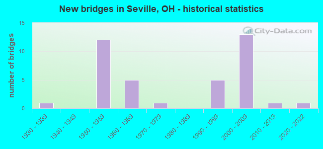
- New bridges - historical statistics
- 11930-1939
- 121950-1959
- 51960-1969
- 11970-1979
- 51990-1999
- 132000-2009
- 12010-2019
- 12020-2022

- Reconstructed bridges - Historical Statistics
- 21990-1999
- 42000-2009


- Bridge Condition - Deck
- 32.0%Excellent
- 24.0%Very good
- 44.0%Good

- Bridge Condition - Superstructure
- 32.0%Excellent
- 20.0%Very good
- 44.0%Good
- 4.0%Satisfactory

- Bridge Condition - Substructure
- 28.0%Excellent
- 28.0%Very good
- 28.0%Good
- 16.0%Satisfactory

- Bridge Condition - Channel
- 38.5%Very good
- 53.8%Good
- 7.7%Satisfactory
Find on map >> Show street view
Structure Number: 5200024, Location: 2.21 MILES N OF WAYNE CO (Lat: 41.010111, Lng: -81.864869), Route carried "on" structure: State highway 3, Year Built: 1934, Year Reconstructed: 2013, Status: Open, Structure Length: 1.86m (6.10ft), Average Daily Traffic: 4,798 (year 2015), Truck Traffic: 7%, Average Future Daily Traffic: 6,660 (year 2035), Design Load: HS 20+Mod, Features Intersected: CHIPPEWA DITCH
Minimum Vertical Clearance: 30+ m (98+ ft), Kilometerpoint: 3.557, Lanes on structure: 2, Base Highway Network: Yes, Owner: State Highway Agency, Approaching Roadway Width: 7.9m (25.9ft), Material/Design: Prestressed concrete, Design/Construction: Box Beam or Girders - Multiple, Number Of Spans In Main Unit: 1, Length of Maximum Span: 17.2m (56.4ft), Curb or Sidewalk Widths: Left: 1.5m (4.9ft), Right: 1.5m (4.9ft), Curb-To-Curb Width: 11.0m (36.1ft), Out-to-Out Width: 14.6m (47.9ft)
Condition: Deck: Excellent, Superstructure: Excellent, Substructure: Good, Channel: Good, Operating Rating: 94.0 metric tons, Method Used To Determine Operating Rating: Load Factor (LF) rating reported by rating factor (RF) method using MS18 loading, Inventory Rating: 58.3 metric tons, Method Used To Determine Inventory Rating: Load Factor (LF) rating reported by rating factor (RF) method using MS18 loading, Structural Evaluation: Better than present minimum criteria, Deck Geometry: Somewhat better than minimum adequacy, Waterway Adequacy: Better than present minimum criteria, Approach Roadway Alignment: Better than present minimum criteria, Designated Inspection Frequency: Every 24 months, Inspection Date: July 2020, Deck Structure Type: Concrete Cast-file-Place, Wearing Surface/Protective System: Wearing Surface: Monolithic Concrete, Deck Protection: Epoxy Coated Reinforcing
Find on map >> Show street view
Structure Number: 5200067, Location: 2.37 MILES N OF WAYNE CO (Lat: 41.010489, Lng: -81.862169), Route carried "on" structure: State highway 3, Year Built: 1995, Status: Open, Structure Length: 1.74m (5.71ft), Average Daily Traffic: 5,085 (year 2015), Truck Traffic: 6%, Average Future Daily Traffic: 7,058 (year 2035), Design Load: HS 20+Mod, Features Intersected: HUBBARD CREEK
Minimum Vertical Clearance: 30+ m (98+ ft), Kilometerpoint: 3.814, Lanes on structure: 2, Base Highway Network: Yes, Owner: State Highway Agency, Approaching Roadway Width: 12.2m (40.0ft), Material/Design: Prestressed concrete, Design/Construction: Box Beam or Girders - Multiple, Number Of Spans In Main Unit: 1, Length of Maximum Span: 16.2m (53.1ft), Curb or Sidewalk Widths: Left: 1.8m (5.9ft), Right: 1.8m (5.9ft), Curb-To-Curb Width: 12.2m (40.0ft), Out-to-Out Width: 12.3m (40.4ft)
Condition: Deck: Very good, Superstructure: Very good, Substructure: Very good, Channel: Satisfactory, Operating Rating: 42.1 metric tons, Method Used To Determine Operating Rating: Load Factor (LF) rating reported by rating factor (RF) method using MS18 loading, Inventory Rating: 32.4 metric tons, Method Used To Determine Inventory Rating: Load Factor (LF) rating reported by rating factor (RF) method using MS18 loading, Structural Evaluation: Equal to present desirable criteria, Deck Geometry: Somewhat better than minimum adequacy, Waterway Adequacy: Better than present minimum criteria, Approach Roadway Alignment: Equal to present desirable criteria, Length Of Structure Improvement: 12.86m (42.19ft), Designated Inspection Frequency: Every 24 months, Inspection Date: November 2020, Bridge Improvement Cost: $176,000, Roadway Improvement Cost: $18,000, Total Project Cost: $266,000, Deck Structure Type: Concrete Cast-file-Place, Wearing Surface/Protective System: Wearing Surface: Monolithic Concrete, Membrane: Epoxy
Find on map >> Show street view
Structure Number: 5200091, Location: OVER IR 76 (Lat: 41.033011, Lng: -81.864200), Route carried "on" structure: State highway 3, Year Built: 1958, Year Reconstructed: 1995, Status: Open, Structure Length: 6.40m (21.00ft), Average Daily Traffic: 9,131 (year 2015), Truck Traffic: 8%, Average Future Daily Traffic: 12,674 (year 2035), Design Load: HS 20+Mod, Features Intersected: OVER MED-076-0232
Minimum Vertical Clearance: 30+ m (98+ ft), Kilometerpoint: 6.357, Lanes on structure: 2, Lanes under structure: 4, Base Highway Network: Yes, Owner: State Highway Agency, Approaching Roadway Width: 18.9m (62.0ft), Material/Design: Steel continuous, Design/Construction: Stringer/Multi-beam, Number Of Spans In Main Unit: 4, Length of Maximum Span: 17.5m (57.4ft), Curb-To-Curb Width: 18.9m (62.0ft), Out-to-Out Width: 19.8m (65.0ft)
Condition: Deck: Good, Superstructure: Good, Substructure: Good, Operating Rating: 42.1 metric tons, Method Used To Determine Operating Rating: Load Factor (LF) rating reported by rating factor (RF) method using MS18 loading, Inventory Rating: 32.4 metric tons, Method Used To Determine Inventory Rating: Load Factor (LF) rating reported by rating factor (RF) method using MS18 loading, Structural Evaluation: Better than present minimum criteria, Deck Geometry: Superior to present desirable criteria, Underclear: Meets minimum limits, Approach Roadway Alignment: Equal to present desirable criteria, Designated Inspection Frequency: Every 24 months, Inspection Date: November 2020, Deck Structure Type: Concrete Cast-file-Place, Wearing Surface/Protective System: Wearing Surface: Monolithic Concrete, Deck Protection: Epoxy Coated Reinforcing
Find on map >> Show street view
Structure Number: 5200121, Location: OVER IR 71 (Lat: 41.050861, Lng: -81.864389), Route carried "on" structure: State highway 3, Year Built: 1959, Status: Open, Structure Length: 13.20m (43.31ft), Average Daily Traffic: 7,935 (year 2015), Truck Traffic: 8%, Average Future Daily Traffic: 11,014 (year 2035), Design Load: HS 15, Features Intersected: OVER MED-071-0993
Minimum Vertical Clearance: 30+ m (98+ ft), Kilometerpoint: 8.352, Lanes on structure: 2, Lanes under structure: 6, Base Highway Network: Yes, Owner: State Highway Agency, Approaching Roadway Width: 7.9m (25.9ft), Skew: 5 degrees, Material/Design: Steel continuous, Design/Construction: Stringer/Multi-beam, Number Of Spans In Main Unit: 4, Length of Maximum Span: 39.3m (128.9ft), Curb or Sidewalk Widths: Left: 0.6m (2.0ft), Right: 0.6m (2.0ft), Curb-To-Curb Width: 9.2m (30.2ft), Out-to-Out Width: 11.2m (36.7ft)
Condition: Deck: Good, Superstructure: Satisfactory, Substructure: Satisfactory, Operating Rating: 51.8 metric tons, Method Used To Determine Operating Rating: Load and Resistance Factor Rating (LRFR) rating reported by rating factor(RF) method using HL-93 loadings, Inventory Rating: 38.9 metric tons, Method Used To Determine Inventory Rating: Load and Resistance Factor Rating (LRFR) rating reported by rating factor(RF) method using HL-93 loadings, Structural Evaluation: Equal to present minimum criteria, Deck Geometry: Meets minimum limits, Underclear: Somewhat better than minimum adequacy, Approach Roadway Alignment: Equal to present desirable criteria, Designated Inspection Frequency: Every 12 months, Inspection Date: September 2021, Deck Structure Type: Concrete Cast-file-Place, Wearing Surface/Protective System: Wearing Surface: Integral Concrete
Find on map >> Show street view
Structure Number: 5202922, Location: 6.06 MILES NORTH OF SR-83 (Lat: 41.030381, Lng: -81.891400), Route carried "on" structure: Interstate 71, Year Built: 2008, Status: Open, Structure Length: 12.77m (41.90ft), Average Daily Traffic: 20,848 (year 2015), Truck Traffic: 7%, Average Future Daily Traffic: 28,937 (year 2035), Design Load: HS 25 or greater, Features Intersected: OVER IR-76
Minimum Vertical Clearance: 30+ m (98+ ft), Kilometerpoint: 12.778, Lanes on structure: 4, Lanes under structure: 4, Base Highway Network: Yes, Owner: State Highway Agency, Approaching Roadway Width: 17.1m (56.1ft), Skew: 6 degrees, Material/Design: Steel continuous, Design/Construction: Stringer/Multi-beam, Number Of Spans In Main Unit: 4, Length of Maximum Span: 40.7m (133.5ft), Curb-To-Curb Width: 21.9m (71.9ft), Out-to-Out Width: 22.9m (75.1ft)
Condition: Deck: Excellent, Superstructure: Excellent, Substructure: Excellent, Operating Rating: 48.6 metric tons, Method Used To Determine Operating Rating: Load and Resistance Factor Rating (LRFR) rating reported by rating factor(RF) method using HL-93 loadings, Inventory Rating: 38.9 metric tons, Method Used To Determine Inventory Rating: Load and Resistance Factor Rating (LRFR) rating reported by rating factor(RF) method using HL-93 loadings, Structural Evaluation: Superior to present desirable criteria, Deck Geometry: Better than present minimum criteria, Underclear: High priority of corrective action, Approach Roadway Alignment: Better than present minimum criteria, Designated Inspection Frequency: Every 24 months, Inspection Date: August 2020, Deck Structure Type: Concrete Cast-file-Place, Wearing Surface/Protective System: Wearing Surface: Monolithic Concrete, Deck Protection: Epoxy Coated Reinforcing
Find on map >> Show street view
Structure Number: 5202957, Location: 6.06 MILES NORTH OF SR-83 (Lat: 41.030389, Lng: -81.890619), Route carried "on" structure: Interstate 71, Year Built: 2008, Status: Open, Structure Length: 12.71m (41.70ft), Average Daily Traffic: 20,848 (year 2015), Truck Traffic: 7%, Average Future Daily Traffic: 28,937 (year 2035), Design Load: HS 25 or greater, Features Intersected: OVER IR-76
Minimum Vertical Clearance: 30+ m (98+ ft), Kilometerpoint: 12.778, Lanes on structure: 3, Lanes under structure: 4, Base Highway Network: Yes, Owner: State Highway Agency, Approaching Roadway Width: 18.9m (62.0ft), Skew: 6 degrees, Material/Design: Steel continuous, Design/Construction: Stringer/Multi-beam, Number Of Spans In Main Unit: 4, Length of Maximum Span: 38.3m (125.7ft), Curb-To-Curb Width: 19.0m (62.3ft), Out-to-Out Width: 19.9m (65.3ft)
Condition: Deck: Excellent, Superstructure: Excellent, Substructure: Excellent, Operating Rating: 42.1 metric tons, Method Used To Determine Operating Rating: Load Factor (LF) rating reported by rating factor (RF) method using MS18 loading, Inventory Rating: 32.4 metric tons, Method Used To Determine Inventory Rating: Load Factor (LF) rating reported by rating factor (RF) method using MS18 loading, Structural Evaluation: Equal to present desirable criteria, Deck Geometry: Superior to present desirable criteria, Underclear: High priority of corrective action, Approach Roadway Alignment: Better than present minimum criteria, Designated Inspection Frequency: Every 24 months, Inspection Date: August 2020, Deck Structure Type: Concrete Cast-file-Place, Wearing Surface/Protective System: Wearing Surface: Monolithic Concrete, Deck Protection: Epoxy Coated Reinforcing
Find on map >> Show street view
Structure Number: 5202965, Location: 0.16 MILES NORTH OF IR-76 (Lat: 41.031911, Lng: -81.887919), Route carried "on" structure: Interstate 71, Year Built: 2008, Status: Open, Structure Length: 3.60m (11.81ft), Average Daily Traffic: 20,848 (year 2015), Truck Traffic: 7%, Average Future Daily Traffic: 28,937 (year 2035), Design Load: HS 25 or greater, Features Intersected: OVER CHIPPEWA DITCH
Minimum Vertical Clearance: 30+ m (98+ ft), Kilometerpoint: 13.036, Lanes on structure: 3, Base Highway Network: Yes, Owner: State Highway Agency, Approaching Roadway Width: 18.0m (59.1ft), Material/Design: Prestressed concrete, Design/Construction: Stringer/Multi-beam, Number Of Spans In Main Unit: 1, Length of Maximum Span: 35.1m (115.2ft), Curb-To-Curb Width: 18.3m (60.0ft), Out-to-Out Width: 19.2m (63.0ft)
Condition: Deck: Excellent, Superstructure: Excellent, Substructure: Excellent, Channel: Very good, Operating Rating: 97.2 metric tons, Method Used To Determine Operating Rating: Load Factor (LF) rating reported by rating factor (RF) method using MS18 loading, Inventory Rating: 58.3 metric tons, Method Used To Determine Inventory Rating: Load Factor (LF) rating reported by rating factor (RF) method using MS18 loading, Structural Evaluation: Superior to present desirable criteria, Deck Geometry: Better than present minimum criteria, Waterway Adequacy: Superior to present desirable criteria, Approach Roadway Alignment: Better than present minimum criteria, Designated Inspection Frequency: Every 24 months, Inspection Date: August 2020, Deck Structure Type: Concrete Cast-file-Place, Wearing Surface/Protective System: Wearing Surface: Monolithic Concrete, Deck Protection: Epoxy Coated Reinforcing
Find on map >> Show street view
Structure Number: 5203015, Location: 0.16 MILES NORTH OF IR-76 (Lat: 41.031661, Lng: -81.887769), Route carried "on" structure: Interstate 71, Year Built: 2008, Status: Open, Structure Length: 3.60m (11.81ft), Average Daily Traffic: 20,848 (year 2015), Truck Traffic: 7%, Average Future Daily Traffic: 28,937 (year 2035), Design Load: HS 25 or greater, Features Intersected: OVER CHIPPEWA DITCH
Minimum Vertical Clearance: 30+ m (98+ ft), Kilometerpoint: 13.036, Lanes on structure: 3, Base Highway Network: Yes, Owner: State Highway Agency, Approaching Roadway Width: 18.0m (59.1ft), Material/Design: Prestressed concrete, Design/Construction: Stringer/Multi-beam, Number Of Spans In Main Unit: 1, Length of Maximum Span: 35.1m (115.2ft), Curb-To-Curb Width: 18.3m (60.0ft), Out-to-Out Width: 19.2m (63.0ft)
Condition: Deck: Excellent, Superstructure: Excellent, Substructure: Excellent, Channel: Very good, Operating Rating: 97.2 metric tons, Method Used To Determine Operating Rating: Load Factor (LF) rating reported by rating factor (RF) method using MS18 loading, Inventory Rating: 58.3 metric tons, Method Used To Determine Inventory Rating: Load Factor (LF) rating reported by rating factor (RF) method using MS18 loading, Structural Evaluation: Superior to present desirable criteria, Deck Geometry: Better than present minimum criteria, Waterway Adequacy: Superior to present desirable criteria, Approach Roadway Alignment: Better than present minimum criteria, Designated Inspection Frequency: Every 24 months, Inspection Date: August 2020, Deck Structure Type: Concrete Cast-file-Place, Wearing Surface/Protective System: Wearing Surface: Monolithic Concrete, Deck Protection: Epoxy Coated Reinforcing
Find on map >> Show street view
Structure Number: 5203031, Location: .66 MI N OF IR 76 (Lat: 41.036369, Lng: -81.880531), Route carried "on" structure: Interstate 71, Year Built: 1959, Year Reconstructed: 2007, Status: Open, Structure Length: 7.71m (25.30ft), Average Daily Traffic: 20,848 (year 2015), Truck Traffic: 7%, Average Future Daily Traffic: 28,937 (year 2035), Design Load: HS 25 or greater, Features Intersected: OVER MED-040-0082/CSXT R
Minimum Vertical Clearance: 30+ m (98+ ft), Kilometerpoint: 13.840, Lanes on structure: 3, Lanes under structure: 2, Base Highway Network: Yes, Owner: State Highway Agency, Approaching Roadway Width: 17.7m (58.1ft), Skew: 2 degrees, Material/Design: Steel continuous, Design/Construction: Stringer/Multi-beam, Number Of Spans In Main Unit: 4, Length of Maximum Span: 21.1m (69.2ft), Curb-To-Curb Width: 18.3m (60.0ft), Out-to-Out Width: 19.2m (63.0ft)
Condition: Deck: Very good, Superstructure: Very good, Substructure: Excellent, Operating Rating: 42.1 metric tons, Method Used To Determine Operating Rating: Load Factor (LF) rating reported by rating factor (RF) method using MS18 loading, Inventory Rating: 32.4 metric tons, Method Used To Determine Inventory Rating: Load Factor (LF) rating reported by rating factor (RF) method using MS18 loading, Structural Evaluation: Equal to present desirable criteria, Deck Geometry: Better than present minimum criteria, Underclear: Meets minimum limits, Approach Roadway Alignment: Equal to present desirable criteria, Designated Inspection Frequency: Every 24 months, Inspection Date: August 2020, Deck Structure Type: Concrete Cast-file-Place, Wearing Surface/Protective System: Wearing Surface: Monolithic Concrete, Deck Protection: Epoxy Coated Reinforcing
Find on map >> Show street view
Structure Number: 5203066, Location: .66 MI N OF IR 76 (Lat: 41.036069, Lng: -81.880400), Route carried "on" structure: Interstate 71, Year Built: 1959, Year Reconstructed: 2007, Status: Open, Structure Length: 7.71m (25.30ft), Average Daily Traffic: 20,848 (year 2015), Truck Traffic: 7%, Average Future Daily Traffic: 28,937 (year 2035), Design Load: HS 25 or greater, Features Intersected: OVER MED-040-0080/CSXT R
Minimum Vertical Clearance: 30+ m (98+ ft), Kilometerpoint: 13.840, Lanes on structure: 3, Lanes under structure: 2, Base Highway Network: Yes, Owner: State Highway Agency, Approaching Roadway Width: 19.8m (65.0ft), Skew: 2 degrees, Material/Design: Steel continuous, Design/Construction: Stringer/Multi-beam, Number Of Spans In Main Unit: 4, Length of Maximum Span: 20.9m (68.6ft), Curb-To-Curb Width: 20.7m (67.9ft), Out-to-Out Width: 21.6m (70.9ft)
Condition: Deck: Very good, Superstructure: Very good, Substructure: Excellent, Operating Rating: 42.1 metric tons, Method Used To Determine Operating Rating: Load Factor (LF) rating reported by rating factor (RF) method using MS18 loading, Inventory Rating: 32.4 metric tons, Method Used To Determine Inventory Rating: Load Factor (LF) rating reported by rating factor (RF) method using MS18 loading, Structural Evaluation: Equal to present desirable criteria, Deck Geometry: Superior to present desirable criteria, Underclear: Meets minimum limits, Approach Roadway Alignment: Equal to present desirable criteria, Designated Inspection Frequency: Every 24 months, Inspection Date: August 2020, Deck Structure Type: Concrete Cast-file-Place, Wearing Surface/Protective System: Wearing Surface: Monolithic Concrete, Deck Protection: Epoxy Coated Reinforcing
Find on map >> Show street view
Structure Number: 5203155, Location: 2.97 MILES NORTH OF IR76 (Lat: 41.062500, Lng: -81.853000), Route carried "on" structure: County highway C0120, Year Built: 1959, Status: Open, Structure Length: 10.18m (33.40ft), Average Daily Traffic: 537 (year 2015), Truck Traffic: 8%, Average Future Daily Traffic: 57,874 (year 2035), Design Load: H 10, Features Intersected: OVER MED-071 -1091, Facility Carried by Structure: TH 120 Good Rd
Minimum Vertical Clearance: 30+ m (98+ ft), Kilometerpoint: 0.950, Lanes on structure: 2, Lanes under structure: 4, Owner: State Highway Agency, Approaching Roadway Width: 7.9m (25.9ft), Skew: 3 degrees, Material/Design: Steel continuous, Design/Construction: Stringer/Multi-beam, Number Of Spans In Main Unit: 4, Length of Maximum Span: 30.5m (100.1ft), Curb or Sidewalk Widths: Left: 0.6m (2.0ft), Right: 0.6m (2.0ft), Curb-To-Curb Width: 7.3m (24.0ft), Out-to-Out Width: 9.4m (30.8ft)
Condition: Deck: Good, Superstructure: Good, Substructure: Good, Operating Rating: 42.1 metric tons, Method Used To Determine Operating Rating: Load Factor (LF) rating reported by rating factor (RF) method using MS18 loading, Inventory Rating: 25.9 metric tons, Method Used To Determine Inventory Rating: Load Factor (LF) rating reported by rating factor (RF) method using MS18 loading, Structural Evaluation: Equal to present minimum criteria, Deck Geometry: Meets minimum limits, Underclear: Somewhat better than minimum adequacy, Approach Roadway Alignment: Equal to present desirable criteria, Designated Inspection Frequency: Every 24 months, Inspection Date: August 2020, Deck Structure Type: Concrete Cast-file-Place, Wearing Surface/Protective System: Wearing Surface: Integral Concrete
Find on map >> Show street view
Structure Number: 520424, Location: .37 MI.E.OF CR19(LAKE RD) (Lat: 41.030731, Lng: -81.899169), Route carried "on" structure: Ramp US 224, Year Built: 2009, Status: Open, Structure Length: 6.07m (19.91ft), Average Daily Traffic: 18,410 (year 2010), Truck Traffic: 16%, Average Future Daily Traffic: 15,018 (year 2030), Design Load: HS 25 or greater, Features Intersected: MED-224-1582
Minimum Vertical Clearance: 30+ m (98+ ft), Kilometerpoint: 25.460, Lanes on structure: 1, Lanes under structure: 5, Owner: State Highway Agency, Approaching Roadway Width: 9.1m (29.9ft), Material/Design: Steel continuous, Design/Construction: Stringer/Multi-beam, Number Of Spans In Main Unit: 2, Length of Maximum Span: 34.4m (112.9ft), Curb-To-Curb Width: 9.1m (29.9ft), Out-to-Out Width: 13.8m (45.3ft)
Condition: Deck: Very good, Superstructure: Excellent, Substructure: Very good, Operating Rating: 42.1 metric tons, Method Used To Determine Operating Rating: Load Factor (LF) rating reported by rating factor (RF) method using MS18 loading, Inventory Rating: 32.4 metric tons, Method Used To Determine Inventory Rating: Load Factor (LF) rating reported by rating factor (RF) method using MS18 loading, Structural Evaluation: Equal to present desirable criteria, Deck Geometry: Superior to present desirable criteria, Underclear: High priority of corrective action, Approach Roadway Alignment: Equal to present minimum criteria, Designated Inspection Frequency: Every 24 months, Inspection Date: July 2020, Deck Structure Type: Concrete Cast-file-Place, Wearing Surface/Protective System: Wearing Surface: Monolithic Concrete, Deck Protection: Epoxy Coated Reinforcing
Find on map >> Show street view
Structure Number: 5204275, Location: I71/I76/US244 INTERCHANGE (Lat: 41.027681, Lng: -81.897961), Route carried "on" structure: Ramp Interstate 71, Year Built: 2009, Status: Open, Structure Length: 7.62m (25.00ft), Average Daily Traffic: 35,350 (year 2010), Truck Traffic: 21%, Average Future Daily Traffic: 43,183 (year 2030), Design Load: HS 25 or greater, Features Intersected: IR-71
Minimum Vertical Clearance: 30+ m (98+ ft), Kilometerpoint: 12.070, Lanes on structure: 2, Lanes under structure: 6, Owner: State Highway Agency, Approaching Roadway Width: 18.9m (62.0ft), Skew: 20 degrees, Material/Design: Steel continuous, Design/Construction: Stringer/Multi-beam, Number Of Spans In Main Unit: 2, Length of Maximum Span: 42.8m (140.4ft), Curb-To-Curb Width: 18.6m (61.0ft), Out-to-Out Width: 19.5m (64.0ft)
Condition: Deck: Excellent, Superstructure: Excellent, Substructure: Excellent, Operating Rating: 42.1 metric tons, Method Used To Determine Operating Rating: Load Factor (LF) rating reported by rating factor (RF) method using MS18 loading, Inventory Rating: 32.4 metric tons, Method Used To Determine Inventory Rating: Load Factor (LF) rating reported by rating factor (RF) method using MS18 loading, Structural Evaluation: Equal to present desirable criteria, Deck Geometry: Superior to present desirable criteria, Underclear: Equal to present minimum criteria, Approach Roadway Alignment: Equal to present minimum criteria, Designated Inspection Frequency: Every 24 months, Inspection Date: August 2020, Deck Structure Type: Concrete Cast-file-Place, Wearing Surface/Protective System: Wearing Surface: Monolithic Concrete, Deck Protection: Epoxy Coated Reinforcing
Find on map >> Show street view
Structure Number: 5204356, Location: 1.12 MI E OF IR 71 (Lat: 41.030719, Lng: -81.887089), Route carried "on" structure: Interstate 76, Year Built: 1958, Status: Open, Structure Length: 2.83m (9.28ft), Average Daily Traffic: 16,215 (year 2015), Truck Traffic: 38%, Average Future Daily Traffic: 22,506 (year 2035), Design Load: HS 20, Features Intersected: OVER CHIPPEWA DITCH
Minimum Vertical Clearance: 30+ m (98+ ft), Kilometerpoint: 1.352, Lanes on structure: 2, Base Highway Network: Yes, Owner: State Highway Agency, Approaching Roadway Width: 18.3m (60.0ft), Skew: 3 degrees, Material/Design: Concrete continuous, Design/Construction: Slab, Number Of Spans In Main Unit: 3, Length of Maximum Span: 10.1m (33.1ft), Curb-To-Curb Width: 12.5m (41.0ft), Out-to-Out Width: 13.4m (44.0ft)
Condition: Deck: Good, Superstructure: Good, Substructure: Satisfactory, Channel: Good, Operating Rating: 42.1 metric tons, Method Used To Determine Operating Rating: Allowable Stress (AS) rating reported by rating factor (RF) method using MS18 loading, Inventory Rating: 32.4 metric tons, Method Used To Determine Inventory Rating: Allowable Stress (AS) rating reported by rating factor (RF) method using MS18 loading, Structural Evaluation: Equal to present minimum criteria, Deck Geometry: Better than present minimum criteria, Waterway Adequacy: Equal to present desirable criteria, Approach Roadway Alignment: Equal to present desirable criteria, Designated Inspection Frequency: Every 12 months, Inspection Date: November 2021, Deck Structure Type: Concrete Cast-file-Place, Wearing Surface/Protective System: Wearing Surface: Integral Concrete
Find on map >> Show street view
Structure Number: 5204399, Location: 1.12 MI. EAST OF IR-71 (Lat: 41.030511, Lng: -81.886931), Route carried "on" structure: Interstate 76, Year Built: 2007, Status: Open, Structure Length: 2.82m (9.25ft), Average Daily Traffic: 16,215 (year 2015), Truck Traffic: 38%, Average Future Daily Traffic: 22,506 (year 2035), Design Load: HS 25 or greater, Features Intersected: OVER CHIPPEWA DITCH
Minimum Vertical Clearance: 30+ m (98+ ft), Kilometerpoint: 1.352, Lanes on structure: 3, Base Highway Network: Yes, Owner: State Highway Agency, Approaching Roadway Width: 17.6m (57.7ft), Skew: 3 degrees, Material/Design: Concrete continuous, Design/Construction: Slab, Number Of Spans In Main Unit: 3, Length of Maximum Span: 10.7m (35.1ft), Curb-To-Curb Width: 18.2m (59.7ft), Out-to-Out Width: 19.1m (62.7ft)
Condition: Deck: Very good, Superstructure: Very good, Substructure: Very good, Channel: Good, Operating Rating: 42.1 metric tons, Method Used To Determine Operating Rating: Load Factor (LF) rating reported by rating factor (RF) method using MS18 loading, Inventory Rating: 32.4 metric tons, Method Used To Determine Inventory Rating: Load Factor (LF) rating reported by rating factor (RF) method using MS18 loading, Structural Evaluation: Equal to present desirable criteria, Deck Geometry: Better than present minimum criteria, Waterway Adequacy: Superior to present desirable criteria, Approach Roadway Alignment: Better than present minimum criteria, Designated Inspection Frequency: Every 24 months, Inspection Date: November 2021, Deck Structure Type: Concrete Cast-file-Place, Wearing Surface/Protective System: Wearing Surface: Monolithic Concrete, Deck Protection: Epoxy Coated Reinforcing
Find on map >> Show street view
Structure Number: 5204429, Location: .67 MI E.IR71 (Lat: 41.031981, Lng: -81.878369), Route carried "on" structure: Interstate 76, Year Built: 1995, Year Reconstructed: 2007, Status: Open, Structure Length: 6.64m (21.78ft), Average Daily Traffic: 16,215 (year 2015), Truck Traffic: 38%, Average Future Daily Traffic: 22,506 (year 2035), Design Load: HS 20+Mod, Features Intersected: OVER CSX/MED-40-0048 CH
Minimum Vertical Clearance: 30+ m (98+ ft), Kilometerpoint: 2.108, Lanes on structure: 3, Lanes under structure: 2, Base Highway Network: Yes, Owner: State Highway Agency, Approaching Roadway Width: 12.2m (40.0ft), Material/Design: Steel continuous, Design/Construction: Stringer/Multi-beam, Number Of Spans In Main Unit: 4, Length of Maximum Span: 18.3m (60.0ft), Curb-To-Curb Width: 16.6m (54.5ft), Out-to-Out Width: 17.6m (57.7ft)
Condition: Deck: Good, Superstructure: Good, Substructure: Very good, Operating Rating: 58.3 metric tons, Method Used To Determine Operating Rating: Load and Resistance Factor Rating (LRFR) rating reported by rating factor(RF) method using HL-93 loadings, Inventory Rating: 45.4 metric tons, Method Used To Determine Inventory Rating: Load and Resistance Factor Rating (LRFR) rating reported by rating factor(RF) method using HL-93 loadings, Structural Evaluation: Better than present minimum criteria, Deck Geometry: Equal to present minimum criteria, Underclear: High priority of corrective action, Approach Roadway Alignment: Equal to present desirable criteria, Designated Inspection Frequency: Every 24 months, Inspection Date: October 2020, Deck Structure Type: Concrete Cast-file-Place, Wearing Surface/Protective System: Wearing Surface: Monolithic Concrete, Deck Protection: Epoxy Coated Reinforcing
Find on map >> Show street view
Structure Number: 5204437, Location: .67 MI E. IR71 (Lat: 41.031761, Lng: -81.878261), Route carried "on" structure: Interstate 76, Year Built: 1995, Status: Open, Structure Length: 6.64m (21.78ft), Average Daily Traffic: 16,215 (year 2015), Truck Traffic: 38%, Average Future Daily Traffic: 22,506 (year 2035), Design Load: HS 20+Mod, Features Intersected: OVER CSX/MED-40-0048 CH
Minimum Vertical Clearance: 30+ m (98+ ft), Kilometerpoint: 2.108, Lanes on structure: 2, Lanes under structure: 2, Base Highway Network: Yes, Owner: State Highway Agency, Approaching Roadway Width: 12.2m (40.0ft), Material/Design: Steel continuous, Design/Construction: Stringer/Multi-beam, Number Of Spans In Main Unit: 4, Length of Maximum Span: 18.3m (60.0ft), Curb-To-Curb Width: 12.2m (40.0ft), Out-to-Out Width: 13.1m (43.0ft)
Condition: Deck: Good, Superstructure: Good, Substructure: Very good, Operating Rating: 58.3 metric tons, Method Used To Determine Operating Rating: Load and Resistance Factor Rating (LRFR) rating reported by rating factor(RF) method using HL-93 loadings, Inventory Rating: 45.4 metric tons, Method Used To Determine Inventory Rating: Load and Resistance Factor Rating (LRFR) rating reported by rating factor(RF) method using HL-93 loadings, Structural Evaluation: Better than present minimum criteria, Deck Geometry: Better than present minimum criteria, Underclear: High priority of corrective action, Approach Roadway Alignment: Equal to present desirable criteria, Designated Inspection Frequency: Every 24 months, Inspection Date: October 2020, Deck Structure Type: Concrete Cast-file-Place, Wearing Surface/Protective System: Wearing Surface: Epoxy Overlay, Deck Protection: Epoxy Coated Reinforcing
Find on map >> Show street view
Structure Number: 5204593, Location: .67 MI E OF SR 3 (Lat: 41.033000, Lng: -81.851631), Route carried "on" structure: Interstate 76, Year Built: 1964, Status: Open, Structure Length: 3.02m (9.91ft), Average Daily Traffic: 14,948 (year 2015), Truck Traffic: 38%, Average Future Daily Traffic: 20,748 (year 2035), Design Load: HS 20, Features Intersected: HUBBARD CREEK
Minimum Vertical Clearance: 30+ m (98+ ft), Kilometerpoint: 4.361, Lanes on structure: 2, Base Highway Network: Yes, Owner: State Highway Agency, Approaching Roadway Width: 13.4m (44.0ft), Material/Design: Concrete continuous, Design/Construction: Slab, Number Of Spans In Main Unit: 3, Length of Maximum Span: 10.7m (35.1ft), Curb-To-Curb Width: 11.6m (38.1ft), Out-to-Out Width: 12.2m (40.0ft)
Condition: Deck: Good, Superstructure: Good, Substructure: Satisfactory, Channel: Good, Operating Rating: 51.8 metric tons, Method Used To Determine Operating Rating: Load Factor (LF) rating reported by rating factor (RF) method using MS18 loading, Inventory Rating: 32.4 metric tons, Method Used To Determine Inventory Rating: Load Factor (LF) rating reported by rating factor (RF) method using MS18 loading, Structural Evaluation: Equal to present minimum criteria, Deck Geometry: Equal to present minimum criteria, Waterway Adequacy: Superior to present desirable criteria, Approach Roadway Alignment: Equal to present desirable criteria, Designated Inspection Frequency: Every 12 months, Inspection Date: October 2021, Deck Structure Type: Concrete Cast-file-Place, Wearing Surface/Protective System: Wearing Surface: Integral Concrete
Find on map >> Show street view
Structure Number: 5204658, Location: .67 MI E OF SR 3 (Lat: 41.032819, Lng: -81.851619), Route carried "on" structure: Interstate 76, Year Built: 1958, Status: Open, Structure Length: 3.02m (9.91ft), Average Daily Traffic: 14,948 (year 2015), Truck Traffic: 38%, Average Future Daily Traffic: 20,748 (year 2035), Design Load: HS 20, Features Intersected: HUBBARD CREEK
Minimum Vertical Clearance: 30+ m (98+ ft), Kilometerpoint: 4.361, Lanes on structure: 2, Base Highway Network: Yes, Owner: State Highway Agency, Approaching Roadway Width: 13.4m (44.0ft), Material/Design: Concrete continuous, Design/Construction: Slab, Number Of Spans In Main Unit: 3, Length of Maximum Span: 10.7m (35.1ft), Curb-To-Curb Width: 12.5m (41.0ft), Out-to-Out Width: 13.4m (44.0ft)
Condition: Deck: Good, Superstructure: Good, Substructure: Satisfactory, Channel: Good, Operating Rating: 51.8 metric tons, Method Used To Determine Operating Rating: Load Factor (LF) rating reported by rating factor (RF) method using MS18 loading, Inventory Rating: 29.2 metric tons, Method Used To Determine Inventory Rating: Load Factor (LF) rating reported by rating factor (RF) method using MS18 loading, Structural Evaluation: Equal to present minimum criteria, Deck Geometry: Better than present minimum criteria, Waterway Adequacy: Superior to present desirable criteria, Approach Roadway Alignment: Equal to present desirable criteria, Designated Inspection Frequency: Every 12 months, Inspection Date: October 2021, Deck Structure Type: Concrete Cast-file-Place, Wearing Surface/Protective System: Wearing Surface: Integral Concrete
Find on map >> Show street view
Structure Number: 5204682, Location: .79 MI E OF SR3 (Lat: 41.032800, Lng: -81.849250), Route carried "on" structure: County highway C0093, Year Built: 1964, Status: Open, Structure Length: 6.25m (20.51ft), Average Daily Traffic: 281 (year 2015), Truck Traffic: 7%, Average Future Daily Traffic: 41,494 (year 2035), Design Load: H 15, Features Intersected: OVER MED-076 -0311 1, Facility Carried by Structure: TH-93 Hubbard Valy
Minimum Vertical Clearance: 30+ m (98+ ft), Kilometerpoint: 25.267, Lanes on structure: 2, Lanes under structure: 4, Owner: State Highway Agency, Approaching Roadway Width: 8.1m (26.6ft), Material/Design: Steel continuous, Design/Construction: Stringer/Multi-beam, Number Of Spans In Main Unit: 4, Length of Maximum Span: 18.2m (59.7ft), Curb-To-Curb Width: 8.1m (26.6ft), Out-to-Out Width: 9.4m (30.8ft)
Condition: Deck: Good, Superstructure: Good, Substructure: Good, Operating Rating: 42.1 metric tons, Method Used To Determine Operating Rating: Load Factor (LF) rating reported by rating factor (RF) method using MS18 loading, Inventory Rating: 32.4 metric tons, Method Used To Determine Inventory Rating: Load Factor (LF) rating reported by rating factor (RF) method using MS18 loading, Structural Evaluation: Better than present minimum criteria, Deck Geometry: Somewhat better than minimum adequacy, Underclear: High priority of corrective action, Approach Roadway Alignment: Equal to present desirable criteria, Designated Inspection Frequency: Every 24 months, Inspection Date: October 2020, Deck Structure Type: Concrete Cast-file-Place, Wearing Surface/Protective System: Wearing Surface: Integral Concrete
Find on map >> Show street view
Structure Number: 5204704, Location: 1.67 MI E OF SR 3 (Lat: 41.032350, Lng: -81.832450), Route carried "on" structure: County highway C0041, Year Built: 1964, Year Reconstructed: 1995, Status: Open, Structure Length: 6.28m (20.60ft), Average Daily Traffic: 476 (year 2015), Truck Traffic: 8%, Average Future Daily Traffic: 41,494 (year 2035), Design Load: HS 20+Mod, Features Intersected: OVER MED-076 -0399, Facility Carried by Structure: CH-41 Guliford Rd
Minimum Vertical Clearance: 30+ m (98+ ft), Kilometerpoint: 48.602, Lanes on structure: 2, Lanes under structure: 4, Owner: State Highway Agency, Approaching Roadway Width: 8.5m (27.9ft), Material/Design: Steel continuous, Design/Construction: Stringer/Multi-beam, Number Of Spans In Main Unit: 4, Length of Maximum Span: 18.2m (59.7ft), Curb-To-Curb Width: 8.5m (27.9ft), Out-to-Out Width: 9.4m (30.8ft)
Condition: Deck: Good, Superstructure: Good, Substructure: Good, Operating Rating: 42.1 metric tons, Method Used To Determine Operating Rating: Load Factor (LF) rating reported by rating factor (RF) method using MS18 loading, Inventory Rating: 32.4 metric tons, Method Used To Determine Inventory Rating: Load Factor (LF) rating reported by rating factor (RF) method using MS18 loading, Structural Evaluation: Better than present minimum criteria, Deck Geometry: Somewhat better than minimum adequacy, Underclear: High priority of corrective action, Approach Roadway Alignment: Equal to present desirable criteria, Designated Inspection Frequency: Every 24 months, Inspection Date: October 2020, Deck Structure Type: Concrete Cast-file-Place, Wearing Surface/Protective System: Wearing Surface: Monolithic Concrete, Deck Protection: Epoxy Coated Reinforcing
Find on map >> Show street view
Structure Number: 5234922, Location: 0.7 mile E of CH 158 (Lat: 41.020000, Lng: -81.876011), Route carried "on" structure: County highway 97, Year Built: 2020, Status: Open, Structure Length: 2.24m (7.35ft), Average Daily Traffic: 3,193 (year 2015), Truck Traffic: 3%, Average Future Daily Traffic: 4,432 (year 2035), Design Load: HL 93, Features Intersected: chippewa creek
Minimum Vertical Clearance: 30+ m (98+ ft), Kilometerpoint: 10.429, Lanes on structure: 2, Owner: County Highway Agency, Approaching Roadway Width: 7.5m (24.6ft), Material/Design: Prestressed concrete, Design/Construction: Box Beam or Girders - Multiple, Number Of Spans In Main Unit: 1, Length of Maximum Span: 22.1m (72.5ft), Curb-To-Curb Width: 9.8m (32.2ft), Out-to-Out Width: 9.8m (32.2ft)
Condition: Deck: Excellent, Superstructure: Excellent, Substructure: Very good, Channel: Very good, Operating Rating: 68.0 metric tons, Method Used To Determine Operating Rating: Load and Resistance Factor Rating (LRFR) rating reported by rating factor(RF) method using HL-93 loadings, Inventory Rating: 35.6 metric tons, Method Used To Determine Inventory Rating: Load and Resistance Factor Rating (LRFR) rating reported by rating factor(RF) method using HL-93 loadings, Structural Evaluation: Equal to present desirable criteria, Deck Geometry: Meets minimum limits, Waterway Adequacy: Superior to present desirable criteria, Approach Roadway Alignment: Equal to present desirable criteria, Length Of Structure Improvement: 2.24m (7.35ft), Designated Inspection Frequency: Every 12 months, Inspection Date: October 2021, Deck Structure Type: Concrete Cast-file-Place, Wearing Surface/Protective System: Wearing Surface: Monolithic Concrete, Membrane: Epoxy, Deck Protection: Epoxy Coated Reinforcing
Find on map >> Show street view
Structure Number: 5235421, Location: 777' E OF RD 146 (Lat: 41.003489, Lng: -81.864181), Route carried "on" structure: County highway 147, Year Built: 1975, Status: Open, Structure Length: 1.46m (4.79ft), Average Daily Traffic: 79 (year 2015), Truck Traffic: 6%, Average Future Daily Traffic: 110 (year 2035), Design Load: HS 20, Features Intersected: CHIPPEWA CREEK
Minimum Vertical Clearance: 30+ m (98+ ft), Kilometerpoint: 0.241, Lanes on structure: 2, Owner: County Highway Agency, Approaching Roadway Width: 6.7m (22.0ft), Material/Design: Steel, Design/Construction: Stringer/Multi-beam, Number Of Spans In Main Unit: 1, Length of Maximum Span: 14.0m (45.9ft), Curb-To-Curb Width: 7.3m (24.0ft), Out-to-Out Width: 7.3m (24.0ft)
Condition: Deck: Excellent, Superstructure: Good, Substructure: Good, Channel: Good, Operating Rating: 45.4 metric tons, Method Used To Determine Operating Rating: Load Factor (LF) rating reported by rating factor (RF) method using MS18 loading, Inventory Rating: 29.2 metric tons, Method Used To Determine Inventory Rating: Load Factor (LF) rating reported by rating factor (RF) method using MS18 loading, Structural Evaluation: Better than present minimum criteria, Deck Geometry: Equal to present minimum criteria, Waterway Adequacy: Equal to present desirable criteria, Approach Roadway Alignment: Equal to present desirable criteria, Designated Inspection Frequency: Every 24 months, Inspection Date: October 2021, Deck Structure Type: Corrugated Steel, Wearing Surface/Protective System: Wearing Surface: Bituminous
Find on map >> Show street view
Structure Number: 524313, Location: AT HUBBARD VALLEY RD. (Lat: 41.047139, Lng: -81.847639), Route carried "on" structure: County highway C0118, Year Built: 2000, Status: Open, Structure Length: 0.85m (2.79ft), Average Daily Traffic: 1,086 (year 2015), Truck Traffic: 8%, Average Future Daily Traffic: 1,507 (year 2035), Design Load: HS 20+Mod, Features Intersected: STREAM, Facility Carried by Structure: BLAKE RD.
Minimum Vertical Clearance: 30+ m (98+ ft), Kilometerpoint: 1.400, Lanes on structure: 2, Owner: County Highway Agency, Approaching Roadway Width: 6.1m (20.0ft), Skew: 1 degrees, Material/Design: Concrete, Design/Construction: Frame, Number Of Spans In Main Unit: 1, Length of Maximum Span: 8.5m (27.9ft), Curb-To-Curb Width: 6.1m (20.0ft), Out-to-Out Width: 6.1m (20.0ft)
Condition: Deck: Good, Superstructure: Good, Substructure: Good, Channel: Good, Operating Rating: 55.1 metric tons, Method Used To Determine Operating Rating: Assigned rating based on Load Factor Design (LFD) reported by rating factor (RF) using MS18 loading, Inventory Rating: 32.4 metric tons, Method Used To Determine Inventory Rating: Assigned rating based on Load Factor Design (LFD) reported by rating factor (RF) using MS18 loading, Structural Evaluation: Better than present minimum criteria, Deck Geometry: High priority of replacement, Waterway Adequacy: Equal to present desirable criteria, Approach Roadway Alignment: Equal to present desirable criteria, Designated Inspection Frequency: Every 24 months, Inspection Date: October 2021, Deck Structure Type: Concrete Cast-file-Place, Wearing Surface/Protective System: Wearing Surface: Bituminous
Find on map >> Show street view
Structure Number: 5243173, Location: JUST W.OF HUBBARD VALL (Lat: 41.025200, Lng: -81.851850), Route carried "on" structure: County highway C0097, Year Built: 2004, Status: Open, Structure Length: 1.68m (5.51ft), Average Daily Traffic: 4,344 (year 2015), Truck Traffic: 3%, Average Future Daily Traffic: 6,029 (year 2035), Design Load: HS 20+Mod, Features Intersected: HUBBARD CREEK, Facility Carried by Structure: GREENWICH RD.
Minimum Vertical Clearance: 30+ m (98+ ft), Kilometerpoint: 13.003, Lanes on structure: 2, Owner: County Highway Agency, Approaching Roadway Width: 6.7m (22.0ft), Material/Design: Prestressed concrete, Design/Construction: Stringer/Multi-beam, Number Of Spans In Main Unit: 1, Length of Maximum Span: 16.8m (55.1ft), Curb-To-Curb Width: 6.7m (22.0ft), Out-to-Out Width: 12.2m (40.0ft)
Condition: Deck: Very good, Superstructure: Very good, Substructure: Very good, Channel: Very good, Operating Rating: 42.1 metric tons, Method Used To Determine Operating Rating: Load Factor (LF) rating reported by rating factor (RF) method using MS18 loading, Inventory Rating: 32.4 metric tons, Method Used To Determine Inventory Rating: Load Factor (LF) rating reported by rating factor (RF) method using MS18 loading, Structural Evaluation: Equal to present desirable criteria, Deck Geometry: High priority of replacement, Waterway Adequacy: Equal to present desirable criteria, Approach Roadway Alignment: Equal to present desirable criteria, Designated Inspection Frequency: Every 24 months, Inspection Date: October 2021, Deck Structure Type: Concrete Cast-file-Place, Wearing Surface/Protective System: Wearing Surface: Bituminous, Membrane: Preformed Fabric
Find on map >> Show street view
Structure Number: 5245184, Location: 0.61 MI EAST OF SR 3 (Lat: 41.047150, Lng: -81.852781), Route carried "on" structure: County highway 118, Year Built: 2010, Status: Open, Structure Length: 0.79m (2.59ft), Average Daily Traffic: 1,086 (year 2015), Truck Traffic: 8%, Average Future Daily Traffic: 1,507 (year 2035), Design Load: HS 25 or greater, Features Intersected: HUBBARD CREEK
Minimum Vertical Clearance: 30+ m (98+ ft), Kilometerpoint: 0.982, Lanes on structure: 2, Owner: County Highway Agency, Approaching Roadway Width: 6.7m (22.0ft), Material/Design: Concrete, Design/Construction: Culvert, Number Of Spans In Main Unit: 1, Length of Maximum Span: 7.9m (25.9ft)
Condition: Channel: Very good, Culverts: Very good, Operating Rating: 97.2 metric tons, Method Used To Determine Operating Rating: Load Factor (LF) rating reported by rating factor (RF) method using MS18 loading, Inventory Rating: 81.0 metric tons, Method Used To Determine Inventory Rating: Load Factor (LF) rating reported by rating factor (RF) method using MS18 loading, Structural Evaluation: Equal to present desirable criteria, Waterway Adequacy: Superior to present desirable criteria, Approach Roadway Alignment: Better than present minimum criteria, Designated Inspection Frequency: Every 24 months, Inspection Date: October 2021
Find on map >> Show street view
Structure Number: 5200091, Location: OVER IR 76 (Lat: 41.033011, Lng: -81.864200), Route carried "under" structure: Interstate 76, Year Built: 1958, Structure Length: 0. m, Average Daily Traffic: 24,353 (year 2015), Truck Traffic: 38%, Features Intersected: UNDER MED-003-0395L, Facility Carried by Structure: SR 3
Minimum Vertical Clearance: 5.26m (17.26ft), Kilometerpoint: 3.734, Lanes on structure: 2, Lanes under structure: 4, Material/Design: Steel continuous, Design/Construction: Stringer/Multi-beam, Length of Maximum Span: 17.5m (57.4ft)
Find on map >> Show street view
Structure Number: 5200121, Location: OVER IR 71 (Lat: 41.050861, Lng: -81.864389), Route carried "under" structure: Interstate 71, Year Built: 1959, Structure Length: 0. m, Average Daily Traffic: 41,696 (year 2015), Truck Traffic: 7%, Features Intersected: UNDER MED-003-0519, Facility Carried by Structure: SR 3
Minimum Vertical Clearance: 4.98m (16.34ft), Kilometerpoint: 15.981, Lanes on structure: 2, Lanes under structure: 6, Material/Design: Steel continuous, Design/Construction: Stringer/Multi-beam, Length of Maximum Span: 39.3m (128.9ft)
Find on map >> Show street view
Structure Number: 5202922, Location: 6.06 MILES NORTH OF SR-83 (Lat: 41.030381, Lng: -81.891400), Route carried "under" structure: Interstate 76, Year Built: 2008, Structure Length: 0. m, Average Daily Traffic: 8,182 (year 2015), Truck Traffic: 38%, Features Intersected: UNDER MED-71-0794L, Facility Carried by Structure: IR 71
Minimum Vertical Clearance: 5.28m (17.32ft), Kilometerpoint: 1.465, Lanes on structure: 4, Lanes under structure: 4, Material/Design: Steel continuous, Design/Construction: Stringer/Multi-beam, Length of Maximum Span: 40.7m (133.5ft)
Find on map >> Show street view
Structure Number: 5202957, Location: 6.06 MILES NORTH OF SR-83 (Lat: 41.030389, Lng: -81.890619), Route carried "under" structure: Interstate 76, Year Built: 2008, Structure Length: 0. m, Average Daily Traffic: 8,182 (year 2015), Truck Traffic: 38%, Features Intersected: UNDER MED-71-0794R, Facility Carried by Structure: IR 71
Minimum Vertical Clearance: 5.28m (17.32ft), Kilometerpoint: 1.513, Lanes on structure: 3, Lanes under structure: 4, Material/Design: Steel continuous, Design/Construction: Stringer/Multi-beam, Length of Maximum Span: 38.3m (125.7ft)
Find on map >> Show street view
Structure Number: 5203031, Location: .66 MI N OF IR 76 (Lat: 41.036369, Lng: -81.880531), Route carried "under" structure: County highway 40, Year Built: 1959, Structure Length: 0. m, Average Daily Traffic: 1,480 (year 2015), Truck Traffic: 5%, Features Intersected: UNDER MED-071 -0860L, Facility Carried by Structure: IR 71
Minimum Vertical Clearance: 7.62m (25.00ft), Kilometerpoint: 1.320, Lanes on structure: 3, Lanes under structure: 2, Material/Design: Steel continuous, Design/Construction: Stringer/Multi-beam, Length of Maximum Span: 21.1m (69.2ft)
Find on map >> Show street view
Structure Number: 5203066, Location: .66 MI N OF IR 76 (Lat: 41.036069, Lng: -81.880400), Route carried "under" structure: County highway 40, Year Built: 1959, Structure Length: 0. m, Average Daily Traffic: 1,480 (year 2015), Truck Traffic: 5%, Features Intersected: UNDER MED-071 -0860R, Facility Carried by Structure: IR 71
Minimum Vertical Clearance: 7.62m (25.00ft), Kilometerpoint: 1.287, Lanes on structure: 3, Lanes under structure: 2, Material/Design: Steel continuous, Design/Construction: Stringer/Multi-beam, Length of Maximum Span: 20.9m (68.6ft)
Find on map >> Show street view
Structure Number: 5203155, Location: 2.97 MILES NORTH OF IR76 (Lat: 41.062500, Lng: -81.853000), Route carried "under" structure: Interstate 71, Year Built: 1959, Structure Length: 0. m, Average Daily Traffic: 41,696 (year 2015), Truck Traffic: 7%, Features Intersected: UNDER MED-120-0059 TH, Facility Carried by Structure: TH 120 Good Rd
Minimum Vertical Clearance: 5.11m (16.77ft), Kilometerpoint: 17.558, Lanes on structure: 2, Lanes under structure: 4, Material/Design: Steel continuous, Design/Construction: Stringer/Multi-beam, Length of Maximum Span: 30.5m (100.1ft)
Find on map >> Show street view
Structure Number: 520424, Location: .37 MI.E.OF CR19(LAKE RD) (Lat: 41.030731, Lng: -81.899169), Route carried "under" structure: US 224, Year Built: 2009, Structure Length: 0. m, Average Daily Traffic: 10,820 (year 2015), Truck Traffic: 18%, Features Intersected: UNDER I71 TO US224 RAMP
Minimum Vertical Clearance: 5.11m (16.77ft), Kilometerpoint: 25.460, Lanes on structure: 1, Lanes under structure: 5, Material/Design: Steel continuous, Design/Construction: Stringer/Multi-beam, Length of Maximum Span: 34.4m (112.9ft)
Find on map >> Show street view
Structure Number: 5204275, Location: I71/I76/US244 INTERCHANGE (Lat: 41.027681, Lng: -81.897961), Route carried "under" structure: Interstate 71, Year Built: 2009, Structure Length: 0. m, Average Daily Traffic: 31,112 (year 2015), Truck Traffic: 7%, Features Intersected: UNDER US224/I71 RAMP
Minimum Vertical Clearance: 5.28m (17.32ft), Kilometerpoint: 12.070, Lanes on structure: 2, Lanes under structure: 6, Material/Design: Steel continuous, Design/Construction: Stringer/Multi-beam, Length of Maximum Span: 42.8m (140.4ft)
Find on map >> Show street view
Structure Number: 5204429, Location: .67 MI E.IR71 (Lat: 41.031981, Lng: -81.878369), Route carried "under" structure: County highway 40CH, Year Built: 1995, Structure Length: 0. m, Average Daily Traffic: 1,480 (year 2015), Truck Traffic: 5%, Features Intersected: IR-76, Facility Carried by Structure: IR 76
Minimum Vertical Clearance: 7.62m (25.00ft), Kilometerpoint: 77.249, Lanes on structure: 3, Lanes under structure: 2, Material/Design: Steel continuous, Design/Construction: Stringer/Multi-beam, Length of Maximum Span: 18.3m (60.0ft)
Find on map >> Show street view
Structure Number: 5204437, Location: .67 MI E. IR71 (Lat: 41.031761, Lng: -81.878261), Route carried "under" structure: County highway 40CH, Year Built: 1995, Structure Length: 0. m, Average Daily Traffic: 1,480 (year 2015), Truck Traffic: 5%, Features Intersected: IR-76, Facility Carried by Structure: IR 76
Minimum Vertical Clearance: 7.62m (25.00ft), Kilometerpoint: 77.249, Lanes on structure: 2, Lanes under structure: 2, Material/Design: Steel continuous, Design/Construction: Stringer/Multi-beam, Length of Maximum Span: 18.3m (60.0ft)
Find on map >> Show street view
Structure Number: 5204682, Location: .79 MI E OF SR3 (Lat: 41.032800, Lng: -81.849250), Route carried "under" structure: Interstate 76, Year Built: 1964, Structure Length: 0. m, Average Daily Traffic: 29,895 (year 2015), Truck Traffic: 38%, Features Intersected: UNDER MED-93-0157 TH, Facility Carried by Structure: TH-93 Hubbard Valy
Minimum Vertical Clearance: 4.88m (16.01ft), Kilometerpoint: 4.554, Lanes on structure: 2, Lanes under structure: 4, Material/Design: Steel continuous, Design/Construction: Stringer/Multi-beam, Length of Maximum Span: 18.2m (59.7ft)
Find on map >> Show street view
Structure Number: 5204704, Location: 1.67 MI E OF SR 3 (Lat: 41.032350, Lng: -81.832450), Route carried "under" structure: Interstate 76, Year Built: 1964, Structure Length: 0. m, Average Daily Traffic: 29,895 (year 2015), Truck Traffic: 38%, Features Intersected: UNDER MED-41-0302 CH, Facility Carried by Structure: CH-41 Guliford Rd
Minimum Vertical Clearance: 4.93m (16.17ft), Kilometerpoint: 5.971, Lanes on structure: 2, Lanes under structure: 4, Material/Design: Steel continuous, Design/Construction: Stringer/Multi-beam, Length of Maximum Span: 18.2m (59.7ft)