Bridge Statistics for Shady Dale, Georgia (GA)
Condition, Traffic, Stress, Structural Evaluation, Project Costs
- National Bridge Inventory (NBI) Statistics
- 11Number of bridges
- 98ft / 29.6mTotal length
- $5,589,000Total costs
- 7,120Total average daily traffic
- 70Total average daily truck traffic
- National Bridge Inventory (NBI) Registered Bridges for Shady Dale
- No street view available for this location
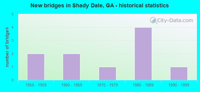
- New bridges - historical statistics
- 21950-1959
- 21960-1969
- 11970-1979
- 41980-1989
- 11990-1999

- Bridge Condition - Deck
- 66.7%Good
- 16.7%Satisfactory
- 16.7%Poor

- Bridge Condition - Superstructure
- 50.0%Good
- 16.7%Satisfactory
- 33.3%Fair

- Bridge Condition - Substructure
- 50.0%Good
- 16.7%Satisfactory
- 33.3%Fair

- Bridge Condition - Channel
- 10.0%Very good
- 80.0%Satisfactory
- 10.0%Fair

- Bridge Condition - Culverts
- 75.0%Good
- 25.0%Satisfactory
Find on map >> Show street view
Structure Number: 1590009, Location: 5.4 MI NE OF MONTICELLO (Lat: 33.365419, Lng: -83.625458), Route carried "on" structure: State highway 83, Year Built: 1963, Status: Open, Structure Length: 10.42m (34.19ft), Average Daily Traffic: 1,710 (year 2011), Truck Traffic: 1%, Average Future Daily Traffic: 2,565 (year 2031), Design Load: HS 20+Mod, Features Intersected: MURDER CREEK
Minimum Vertical Clearance: 30+ m (98+ ft), Kilometerpoint: 32.187, Lanes on structure: 2, Base Highway Network: Yes, Owner: State Highway Agency, Approaching Roadway Width: 7.3m (24.0ft), Material/Design: Concrete, Design/Construction: Tee Beam, Number Of Spans In Main Unit: 9, Length of Maximum Span: 11.6m (38.1ft), Curb or Sidewalk Widths: Left: 0.6m (2.0ft), Right: 0.6m (2.0ft), Curb-To-Curb Width: 8.5m (27.9ft), Out-to-Out Width: 10.5m (34.4ft)
Condition: Deck: Good, Superstructure: Good, Substructure: Fair, Channel: Satisfactory, Operating Rating: 34.4 metric tons, Method Used To Determine Operating Rating: Load Factor (LF), Inventory Rating: 18.1 metric tons, Method Used To Determine Inventory Rating: Load Factor (LF), Structural Evaluation: Somewhat better than minimum adequacy, Deck Geometry: Somewhat better than minimum adequacy, Waterway Adequacy: Equal to present desirable criteria, Approach Roadway Alignment: Equal to present minimum criteria, Designated Inspection Frequency: Every 24 months, Inspection Date: August 2021, Bridge Improvement Cost: $1,336,000, Roadway Improvement Cost: $134,000, Total Project Cost: $2,004,000, Deck Structure Type: Concrete Cast-file-Place
Find on map >> Show street view
Structure Number: 159001, Location: 3 MI NE OF SHADY DALE (Lat: 33.433700, Lng: -83.553419), Route carried "on" structure: State highway 83, Year Built: 1963, Status: Open, Structure Length: 4.39m (14.40ft), Average Daily Traffic: 2,350 (year 2011), Truck Traffic: 1%, Average Future Daily Traffic: 3,525 (year 2031), Design Load: HS 20+Mod, Features Intersected: GAP CREEK
Minimum Vertical Clearance: 30+ m (98+ ft), Kilometerpoint: 43.452, Lanes on structure: 2, Base Highway Network: Yes, Owner: State Highway Agency, Approaching Roadway Width: 7.3m (24.0ft), Skew: 3 degrees, Material/Design: Concrete, Design/Construction: Tee Beam, Number Of Spans In Main Unit: 4, Length of Maximum Span: 11.0m (36.1ft), Curb or Sidewalk Widths: Left: 0.6m (2.0ft), Right: 0.6m (2.0ft), Curb-To-Curb Width: 8.5m (27.9ft), Out-to-Out Width: 10.5m (34.4ft)
Condition: Deck: Good, Superstructure: Good, Substructure: Good, Channel: Satisfactory, Operating Rating: 53.5 metric tons, Method Used To Determine Operating Rating: Load Factor (LF), Inventory Rating: 32.6 metric tons, Method Used To Determine Inventory Rating: Load Factor (LF), Structural Evaluation: Better than present minimum criteria, Deck Geometry: Meets minimum limits, Waterway Adequacy: Equal to present desirable criteria, Approach Roadway Alignment: Equal to present minimum criteria, Designated Inspection Frequency: Every 24 months, Inspection Date: July 2021, Bridge Improvement Cost: $563,000, Roadway Improvement Cost: $56,000, Total Project Cost: $844,000, Deck Structure Type: Concrete Cast-file-Place
Find on map >> Show street view
Structure Number: 1590026, Location: 7.4 MI N OF MONTICELLO (Lat: 33.406589, Lng: -83.640878), Route carried "on" structure: County highway 2135, Year Built: 1981, Status: Posted for load, Structure Length: 4.27m (14.01ft), Average Daily Traffic: 210 (year 2011), Truck Traffic: 1%, Average Future Daily Traffic: 315 (year 2031), Design Load: HS 15, Features Intersected: MURDER CREEK, Facility Carried by Structure: BAR BRIDGE ROAD
Minimum Vertical Clearance: 30+ m (98+ ft), Kilometerpoint: 11.265, Lanes on structure: 2, Base Highway Network: Yes, Owner: County Highway Agency, Approaching Roadway Width: 6.4m (21.0ft), Material/Design: Concrete, Design/Construction: Slab, Number Of Spans In Main Unit: 7, Length of Maximum Span: 6.1m (20.0ft), Curb-To-Curb Width: 10.0m (32.8ft), Out-to-Out Width: 10.8m (35.4ft)
Condition: Deck: Satisfactory, Superstructure: Satisfactory, Substructure: Good, Channel: Satisfactory, Operating Rating: 24.4 metric tons, Method Used To Determine Operating Rating: Load Factor (LF), Inventory Rating: 12.7 metric tons, Method Used To Determine Inventory Rating: Load Factor (LF), Structural Evaluation: Meets minimum limits, Deck Geometry: Better than present minimum criteria, Waterway Adequacy: Equal to present desirable criteria, Approach Roadway Alignment: Better than present minimum criteria, Bridge Posting: Required (Relationship of Operating Rating to Maximum Legal Load: 20.0 - 29.9% below), Designated Inspection Frequency: Every 24 months, Inspection Date: July 2021, Bridge Improvement Cost: $547,000, Roadway Improvement Cost: $55,000, Total Project Cost: $821,000, Deck Structure Type: Concrete Precast Panels
Find on map >> Show street view
Structure Number: 1595016, Location: 2.3 MI SW OF SHADY DALE (Lat: 33.387769, Lng: -83.626689), Route carried "on" structure: County highway 25, Year Built: 1981, Status: Posted for load, Structure Length: 4.88m (16.01ft), Average Daily Traffic: 104 (year 2011), Truck Traffic: 1%, Average Future Daily Traffic: 156 (year 2031), Design Load: HS 15, Features Intersected: MURDER CREEK, Facility Carried by Structure: KING PLOW ROAD
Minimum Vertical Clearance: 30+ m (98+ ft), Kilometerpoint: 3.219, Lanes on structure: 2, Base Highway Network: Yes, Owner: County Highway Agency, Approaching Roadway Width: 6.1m (20.0ft), Material/Design: Concrete, Design/Construction: Slab, Number Of Spans In Main Unit: 8, Length of Maximum Span: 6.1m (20.0ft), Curb-To-Curb Width: 10.0m (32.8ft), Out-to-Out Width: 10.8m (35.4ft)
Condition: Deck: Good, Superstructure: Good, Substructure: Good, Channel: Fair, Operating Rating: 22.6 metric tons, Method Used To Determine Operating Rating: Load Factor (LF), Inventory Rating: 13.6 metric tons, Method Used To Determine Inventory Rating: Load Factor (LF), Structural Evaluation: Meets minimum limits, Deck Geometry: Better than present minimum criteria, Waterway Adequacy: Equal to present desirable criteria, Approach Roadway Alignment: Equal to present desirable criteria, Bridge Posting: Required (Relationship of Operating Rating to Maximum Legal Load: 30.0 - 39.9% below), Designated Inspection Frequency: Every 24 months, Inspection Date: July 2021, Bridge Improvement Cost: $625,000, Roadway Improvement Cost: $63,000, Total Project Cost: $938,000, Deck Structure Type: Concrete Precast Panels
Find on map >> Show street view
Structure Number: 1595025, Location: 2.4 MI E OF SHADY DALE (Lat: 33.401589, Lng: -83.548819), Route carried "on" structure: County highway 54, Year Built: 1987, Status: Open, Structure Length: 0.82m (2.69ft), Average Daily Traffic: 104 (year 2011), Truck Traffic: 1%, Average Future Daily Traffic: 156 (year 2031), Features Intersected: HANNA BRANCH, Facility Carried by Structure: STOCK FARM ROAD
Minimum Vertical Clearance: 30+ m (98+ ft), Kilometerpoint: 1.609, Lanes on structure: 2, Base Highway Network: Yes, Owner: County Highway Agency, Approaching Roadway Width: 4.9m (16.1ft), Material/Design: Steel, Design/Construction: Culvert, Number Of Spans In Main Unit: 3, Length of Maximum Span: 2.1m (6.9ft)
Condition: Channel: Satisfactory, Culverts: Good, Operating Rating: 41.7 metric tons, Method Used To Determine Operating Rating: Field evaluation and documented engineering judgment, Inventory Rating: 24.4 metric tons, Method Used To Determine Inventory Rating: Field evaluation and documented engineering judgment, Structural Evaluation: Equal to present minimum criteria, Waterway Adequacy: Equal to present desirable criteria, Approach Roadway Alignment: Equal to present minimum criteria, Designated Inspection Frequency: Every 24 months, Inspection Date: July 2021, Bridge Improvement Cost: $105,000, Roadway Improvement Cost: $11,000, Total Project Cost: $158,000
Find on map >> Show street view
Structure Number: 1595027, Location: 1.6 MI E OF SHADY DALE (Lat: 33.397819, Lng: -83.562139), Route carried "on" structure: County highway 61, Year Built: 1950, Status: Posted for load, Structure Length: 0.94m (3.08ft), Average Daily Traffic: 104 (year 2011), Truck Traffic: 1%, Average Future Daily Traffic: 156 (year 2031), Features Intersected: HANNA BRANCH, Facility Carried by Structure: WHITTEN ROAD
Minimum Vertical Clearance: 30+ m (98+ ft), Kilometerpoint: 0.000, Lanes on structure: 1, Base Highway Network: Yes, Owner: County Highway Agency, Approaching Roadway Width: 4.9m (16.1ft), Material/Design: Steel, Design/Construction: Stringer/Multi-beam, Number Of Spans In Main Unit: 1, Length of Maximum Span: 9.4m (30.8ft), Curb-To-Curb Width: 3.2m (10.5ft), Out-to-Out Width: 3.7m (12.1ft)
Condition: Deck: Poor, Superstructure: Fair, Substructure: Fair, Channel: Satisfactory, Operating Rating: 6.3 metric tons, Method Used To Determine Operating Rating: Load Factor (LF), Inventory Rating: 3.6 metric tons, Method Used To Determine Inventory Rating: Load Factor (LF), Structural Evaluation: High priority of replacement, Deck Geometry: High priority of replacement, Waterway Adequacy: Equal to present minimum criteria, Approach Roadway Alignment: Equal to present minimum criteria, Bridge Posting: Required (Relationship of Operating Rating to Maximum Legal Load: > 39.9% below), Length Of Structure Improvement: 163.37m (535.99ft), Designated Inspection Frequency: Every 24 months, Inspection Date: July 2021, Bridge Improvement Cost: $88,000, Roadway Improvement Cost: $9,000, Total Project Cost: $132,000, Deck Structure Type: Wood or Timber, Wearing Surface/Protective System: Wearing Surface: Wood or Timber
Find on map >> Show street view
Structure Number: 1595063, Location: 5.2 MI NE OF MONTICELLO (Lat: 33.345519, Lng: -83.608428), Route carried "on" structure: County highway 214, Year Built: 1950, Status: Posted for load, Structure Length: 1.22m (4.00ft), Average Daily Traffic: 104 (year 2011), Truck Traffic: 1%, Average Future Daily Traffic: 156 (year 2031), Features Intersected: JACK CREEK, Facility Carried by Structure: RIVER ROAD
Minimum Vertical Clearance: 30+ m (98+ ft), Kilometerpoint: 0.000, Lanes on structure: 1, Base Highway Network: Yes, Owner: County Highway Agency, Approaching Roadway Width: 4.3m (14.1ft), Material/Design: Steel, Design/Construction: Stringer/Multi-beam, Number Of Spans In Main Unit: 1, Length of Maximum Span: 12.2m (40.0ft), Curb-To-Curb Width: 4.1m (13.5ft), Out-to-Out Width: 4.3m (14.1ft)
Condition: Deck: Good, Superstructure: Fair, Substructure: Satisfactory, Channel: Satisfactory, Operating Rating: 7.2 metric tons, Method Used To Determine Operating Rating: Load Factor (LF), Inventory Rating: 4.5 metric tons, Method Used To Determine Inventory Rating: Load Factor (LF), Structural Evaluation: High priority of replacement, Deck Geometry: High priority of replacement, Waterway Adequacy: Equal to present minimum criteria, Approach Roadway Alignment: Equal to present minimum criteria, Bridge Posting: Required (Relationship of Operating Rating to Maximum Legal Load: > 39.9% below), Length Of Structure Improvement: 42.55m (139.60ft), Designated Inspection Frequency: Every 24 months, Inspection Date: July 2021, Bridge Improvement Cost: $114,000, Roadway Improvement Cost: $11,000, Total Project Cost: $170,000, Deck Structure Type: Wood or Timber, Wearing Surface/Protective System: Wearing Surface: Wood or Timber
Find on map >> Show street view
Structure Number: 1595067, Location: 3 MI SW OF SHADY DALE (Lat: 33.363758, Lng: -83.600478), Route carried "on" structure: County highway 78, Year Built: 1987, Status: Open, Structure Length: 0.76m (2.49ft), Average Daily Traffic: 20 (year 2011), Truck Traffic: 1%, Average Future Daily Traffic: 30 (year 2031), Design Load: H 15, Features Intersected: JACK CREEK, Facility Carried by Structure: DEER FIELD FARM RD
Minimum Vertical Clearance: 30+ m (98+ ft), Kilometerpoint: 3.219, Lanes on structure: 2, Base Highway Network: Yes, Owner: County Highway Agency, Approaching Roadway Width: 6.1m (20.0ft), Skew: 1 degrees, Material/Design: Steel, Design/Construction: Culvert, Number Of Spans In Main Unit: 3, Length of Maximum Span: 2.1m (6.9ft)
Condition: Channel: Satisfactory, Culverts: Satisfactory, Operating Rating: 41.7 metric tons, Method Used To Determine Operating Rating: Field evaluation and documented engineering judgment, Inventory Rating: 24.4 metric tons, Method Used To Determine Inventory Rating: Field evaluation and documented engineering judgment, Structural Evaluation: Equal to present minimum criteria, Waterway Adequacy: Better than present minimum criteria, Approach Roadway Alignment: Equal to present minimum criteria, Designated Inspection Frequency: Every 24 months, Inspection Date: August 2021, Bridge Improvement Cost: $98,000, Roadway Improvement Cost: $10,000, Total Project Cost: $147,000
Find on map >> Show street view
Structure Number: 1595072, Location: 3.7 MI N OF SHADY DALE (Lat: 33.454878, Lng: -83.582650), Route carried "on" structure: County highway 39, Year Built: 1999, Status: Open, Structure Length: 0.82m (2.69ft), Average Daily Traffic: 104 (year 2011), Truck Traffic: 1%, Average Future Daily Traffic: 156 (year 2031), Design Load: H 15, Features Intersected: TURKEY CREEK, Facility Carried by Structure: MIDWAY ROAD
Minimum Vertical Clearance: 30+ m (98+ ft), Kilometerpoint: 1.609, Lanes on structure: 2, Base Highway Network: Yes, Owner: County Highway Agency, Approaching Roadway Width: 4.9m (16.1ft), Material/Design: Steel, Design/Construction: Culvert, Number Of Spans In Main Unit: 3, Length of Maximum Span: 2.1m (6.9ft)
Condition: Channel: Very good, Culverts: Good, Operating Rating: 41.7 metric tons, Method Used To Determine Operating Rating: Field evaluation and documented engineering judgment, Inventory Rating: 24.4 metric tons, Method Used To Determine Inventory Rating: Field evaluation and documented engineering judgment, Structural Evaluation: Equal to present minimum criteria, Waterway Adequacy: Better than present minimum criteria, Approach Roadway Alignment: Equal to present minimum criteria, Designated Inspection Frequency: Every 24 months, Inspection Date: July 2021, Bridge Improvement Cost: $105,000, Roadway Improvement Cost: $11,000, Total Project Cost: $158,000
Find on map >> Show street view
Structure Number: 2115044, Location: 3.4 MI W OF GODFREY (Lat: 33.457269, Lng: -83.561139), Route carried "on" structure: County highway 253, Year Built: 1972, Status: Open, Structure Length: 1.13m (3.71ft), Average Daily Traffic: 600 (year 2011), Truck Traffic: 1%, Average Future Daily Traffic: 900 (year 2031), Design Load: HS 20+Mod, Features Intersected: GAP CREEK, Facility Carried by Structure: LITTLE RIVER ROAD
Minimum Vertical Clearance: 30+ m (98+ ft), Kilometerpoint: 3.219, Lanes on structure: 2, Base Highway Network: Yes, Owner: County Highway Agency, Approaching Roadway Width: 6.4m (21.0ft), Skew: 3 degrees, Material/Design: Concrete, Design/Construction: Culvert, Number Of Spans In Main Unit: 3, Length of Maximum Span: 3.7m (12.1ft)
Condition: Channel: Satisfactory, Culverts: Good, Operating Rating: 55.3 metric tons, Method Used To Determine Operating Rating: Field evaluation and documented engineering judgment, Inventory Rating: 32.6 metric tons, Method Used To Determine Inventory Rating: Field evaluation and documented engineering judgment, Structural Evaluation: Better than present minimum criteria, Waterway Adequacy: Equal to present desirable criteria, Approach Roadway Alignment: Equal to present desirable criteria, Designated Inspection Frequency: Every 24 months, Inspection Date: July 2020, Bridge Improvement Cost: $145,000, Roadway Improvement Cost: $14,000, Total Project Cost: $217,000
Find on map >> Show street view
Structure Number: 1590028, Location: .6 MI SW OF SHADY DALE (Lat: 33.393947, Lng: -83.595669), Route carried "under" structure: State highway 83, Structure Length: 0. m, Average Daily Traffic: 1,710 (year 2011), Truck Traffic: 1%, Features Intersected: SR 83, Facility Carried by Structure: NOR-SOU RAILROAD
Minimum Vertical Clearance: 4.74m (15.55ft), Kilometerpoint: 37.015, Length of Maximum Span: 0.0m