Bridge Statistics for Shady Hills, Florida (FL)
Condition, Traffic, Stress, Structural Evaluation, Project Costs
- National Bridge Inventory (NBI) Statistics
- 17Number of bridges
- 194ft / 59.0mTotal length
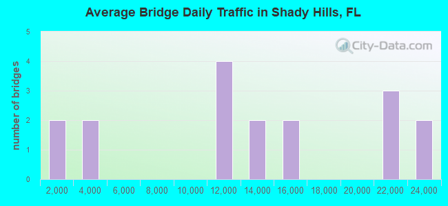
- 212,000Total average daily traffic
- 23,540Total average daily truck traffic
- National Bridge Inventory (NBI) Registered Bridges for Shady Hills
- No street view available for this location
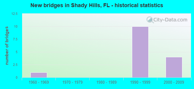
- New bridges - historical statistics
- 11930-1939
- 21960-1969
- 101990-1999
- 42000-2009
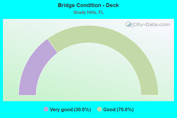
- Bridge Condition - Deck
- 30.0%Very good
- 70.0%Good
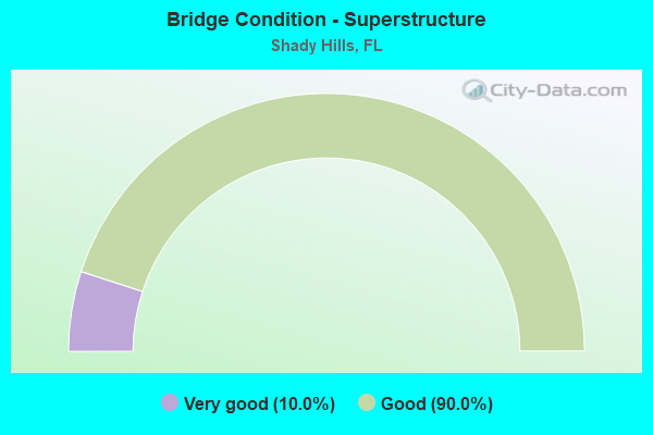
- Bridge Condition - Superstructure
- 10.0%Very good
- 90.0%Good
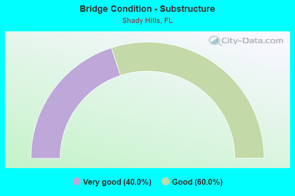
- Bridge Condition - Substructure
- 40.0%Very good
- 60.0%Good
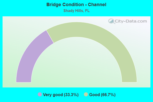
- Bridge Condition - Channel
- 33.3%Very good
- 66.7%Good
Find on map >> Show street view
Structure Number: 140004, Location: 4.7MILES NORTH OF SR-52 (Lat: 28.385147, Lng: -82.489197), Route carried "on" structure: US 41, Year Built: 1939, Status: Open, Structure Length: 1.55m (5.09ft), Average Daily Traffic: 12,500 (year 2021), Truck Traffic: 11%, Average Future Daily Traffic: 21,688 (year 2041), Design Load: H 15, Features Intersected: SCOTTS CANAL
Minimum Vertical Clearance: 30+ m (98+ ft), Kilometerpoint: 25.782, Lanes on structure: 2, Base Highway Network: Yes, Owner: State Highway Agency, Approaching Roadway Width: 9.2m (30.2ft), Material/Design: Concrete, Design/Construction: Tee Beam, Number Of Spans In Main Unit: 2, Length of Maximum Span: 7.7m (25.3ft), Curb or Sidewalk Widths: Left: 0.5m (1.6ft), Right: 0.5m (1.6ft), Curb-To-Curb Width: 9.2m (30.2ft), Out-to-Out Width: 10.6m (34.8ft)
Condition: Deck: Good, Superstructure: Good, Substructure: Very good, Channel: Good, Operating Rating: 72.6 metric tons, Method Used To Determine Operating Rating: Load Factor (LF), Inventory Rating: 43.5 metric tons, Method Used To Determine Inventory Rating: Load Factor (LF), Structural Evaluation: Better than present minimum criteria, Deck Geometry: High priority of corrective action, Waterway Adequacy: Equal to present desirable criteria, Approach Roadway Alignment: Equal to present desirable criteria, Designated Inspection Frequency: Every 24 months, Inspection Date: Febuary 2021, Deck Structure Type: Concrete Cast-file-Place, Wearing Surface/Protective System: Wearing Surface: Bituminous
Find on map >> Show street view
Structure Number: 140028, Location: 1.7MI S OF CR-578 (Lat: 28.413178, Lng: -82.473269), Route carried "on" structure: US 41, Year Built: 1969, Status: Open, Structure Length: 4.57m (14.99ft), Average Daily Traffic: 12,500 (year 2021), Truck Traffic: 11%, Average Future Daily Traffic: 21,688 (year 2041), Design Load: HS 20, Features Intersected: MASARYKTOWN CANAL (C534)
Minimum Vertical Clearance: 30+ m (98+ ft), Kilometerpoint: 29.345, Lanes on structure: 2, Base Highway Network: Yes, Owner: State Highway Agency, Approaching Roadway Width: 9.7m (31.8ft), Material/Design: Prestressed concrete, Design/Construction: Slab, Number Of Spans In Main Unit: 5, Length of Maximum Span: 9.1m (29.9ft), Curb-To-Curb Width: 12.1m (39.7ft), Out-to-Out Width: 14.2m (46.6ft)
Condition: Deck: Good, Superstructure: Good, Substructure: Good, Channel: Good, Operating Rating: 59.9 metric tons, Method Used To Determine Operating Rating: Load Factor (LF), Inventory Rating: 48.1 metric tons, Method Used To Determine Inventory Rating: Load Factor (LF), Structural Evaluation: Better than present minimum criteria, Deck Geometry: Somewhat better than minimum adequacy, Waterway Adequacy: Equal to present desirable criteria, Approach Roadway Alignment: Equal to present desirable criteria, Designated Inspection Frequency: Every 24 months, Inspection Date: Febuary 2021, Deck Structure Type: Concrete Precast Panels, Wearing Surface/Protective System: Wearing Surface: Bituminous
Find on map >> Show street view
Structure Number: 140082, Location: 9.8 MI N SR 54 (Lat: 28.330769, Lng: -82.552117), Route carried "on" structure: State highway 589, Year Built: 2000, Status: Open, Structure Length: 5.40m (17.72ft), Average Daily Traffic: 15,650 (year 2020), Truck Traffic: 10%, Average Future Daily Traffic: 27,153 (year 2042), Design Load: HS 20, Features Intersected: SR 52
Minimum Vertical Clearance: 30+ m (98+ ft), Kilometerpoint: 17.809, Lanes on structure: 2, Lanes under structure: 7, Base Highway Network: Yes, Toll: On toll road, Owner: State Toll Authority, Approaching Roadway Width: 12.2m (40.0ft), Material/Design: Steel, Design/Construction: Stringer/Multi-beam, Number Of Spans In Main Unit: 1, Length of Maximum Span: 54.0m (177.2ft), Curb-To-Curb Width: 12.2m (40.0ft), Out-to-Out Width: 12.8m (42.0ft)
Condition: Deck: Very good, Superstructure: Good, Substructure: Good, Operating Rating: 57.2 metric tons, Method Used To Determine Operating Rating: Load Factor (LF), Inventory Rating: 34.3 metric tons, Method Used To Determine Inventory Rating: Load Factor (LF), Structural Evaluation: Better than present minimum criteria, Deck Geometry: Better than present minimum criteria, Underclear: Better than present minimum criteria, Approach Roadway Alignment: Equal to present desirable criteria, Designated Inspection Frequency: Every 24 months, Inspection Date: June 2020, Deck Structure Type: Concrete Cast-file-Place
Find on map >> Show street view
Structure Number: 140083, Location: 9.8 MI N of SR 54 (Lat: 28.330789, Lng: -82.552394), Route carried "on" structure: State highway 589, Year Built: 2000, Status: Open, Structure Length: 5.40m (17.72ft), Average Daily Traffic: 15,650 (year 2020), Truck Traffic: 10%, Average Future Daily Traffic: 27,153 (year 2042), Design Load: HS 20, Features Intersected: SR 52
Minimum Vertical Clearance: 30+ m (98+ ft), Kilometerpoint: 17.809, Lanes on structure: 2, Lanes under structure: 7, Base Highway Network: Yes, Toll: On toll road, Owner: State Toll Authority, Approaching Roadway Width: 12.2m (40.0ft), Material/Design: Steel, Design/Construction: Stringer/Multi-beam, Number Of Spans In Main Unit: 1, Length of Maximum Span: 54.0m (177.2ft), Curb-To-Curb Width: 12.2m (40.0ft), Out-to-Out Width: 12.8m (42.0ft)
Condition: Deck: Very good, Superstructure: Good, Substructure: Very good, Operating Rating: 57.2 metric tons, Method Used To Determine Operating Rating: Load Factor (LF), Inventory Rating: 34.3 metric tons, Method Used To Determine Inventory Rating: Load Factor (LF), Structural Evaluation: Better than present minimum criteria, Deck Geometry: Better than present minimum criteria, Underclear: Superior to present desirable criteria, Approach Roadway Alignment: Equal to present desirable criteria, Designated Inspection Frequency: Every 24 months, Inspection Date: June 2020, Deck Structure Type: Concrete Cast-file-Place
Find on map >> Show street view
Structure Number: 140084, Location: 2.9 MI N OF SR 52 (Lat: 28.371719, Lng: -82.543214), Route carried "on" structure: State highway 589, Year Built: 1999, Status: Open, Structure Length: 4.95m (16.24ft), Average Daily Traffic: 10,500 (year 2020), Truck Traffic: 10%, Average Future Daily Traffic: 18,218 (year 2042), Design Load: HS 20+Mod, Features Intersected: SHADY HILLS RD
Minimum Vertical Clearance: 30+ m (98+ ft), Kilometerpoint: 22.550, Lanes on structure: 2, Lanes under structure: 2, Base Highway Network: Yes, Toll: On toll road, Owner: State Toll Authority, Approaching Roadway Width: 12.2m (40.0ft), Skew: 1 degrees, Material/Design: Prestressed concrete, Design/Construction: Stringer/Multi-beam, Number Of Spans In Main Unit: 2, Length of Maximum Span: 24.8m (81.4ft), Curb-To-Curb Width: 12.2m (40.0ft), Out-to-Out Width: 12.8m (42.0ft)
Condition: Deck: Good, Superstructure: Very good, Substructure: Very good, Operating Rating: 37.4 metric tons, Method Used To Determine Operating Rating: Load and Resistance Factor (LRFR), Inventory Rating: 34.6 metric tons, Method Used To Determine Inventory Rating: Load and Resistance Factor (LRFR), Structural Evaluation: Equal to present desirable criteria, Deck Geometry: Better than present minimum criteria, Underclear: Equal to present minimum criteria, Approach Roadway Alignment: Equal to present desirable criteria, Designated Inspection Frequency: Every 24 months, Inspection Date: May 2020, Deck Structure Type: Concrete Cast-file-Place
Find on map >> Show street view
Structure Number: 140085, Location: 2.9 MI N OF SR 52 (Lat: 28.371886, Lng: -82.543458), Route carried "on" structure: State highway 589, Year Built: 1999, Status: Open, Structure Length: 4.95m (16.24ft), Average Daily Traffic: 10,500 (year 2020), Truck Traffic: 10%, Average Future Daily Traffic: 18,218 (year 2042), Design Load: HS 20+Mod, Features Intersected: SHADY HILLS RD
Minimum Vertical Clearance: 30+ m (98+ ft), Kilometerpoint: 22.558, Lanes on structure: 2, Lanes under structure: 2, Base Highway Network: Yes, Toll: On toll road, Owner: State Toll Authority, Approaching Roadway Width: 12.2m (40.0ft), Skew: 1 degrees, Material/Design: Prestressed concrete, Design/Construction: Stringer/Multi-beam, Number Of Spans In Main Unit: 2, Length of Maximum Span: 24.8m (81.4ft), Curb-To-Curb Width: 12.2m (40.0ft), Out-to-Out Width: 12.8m (42.0ft)
Condition: Deck: Good, Superstructure: Good, Substructure: Very good, Operating Rating: 37.4 metric tons, Method Used To Determine Operating Rating: Load and Resistance Factor (LRFR), Inventory Rating: 34.6 metric tons, Method Used To Determine Inventory Rating: Load and Resistance Factor (LRFR), Structural Evaluation: Better than present minimum criteria, Deck Geometry: Better than present minimum criteria, Underclear: Equal to present minimum criteria, Approach Roadway Alignment: Equal to present desirable criteria, Designated Inspection Frequency: Every 24 months, Inspection Date: May 2020, Deck Structure Type: Concrete Cast-file-Place
Find on map >> Show street view
Structure Number: 140086, Location: 4.0MI N OF SR 52 (Lat: 28.386461, Lng: -82.536592), Route carried "on" structure: State highway 589, Year Built: 1999, Status: Open, Structure Length: 9.18m (30.12ft), Average Daily Traffic: 3,000 (year 2016), Truck Traffic: 9%, Average Future Daily Traffic: 4,000 (year 2037), Design Load: HS 20, Features Intersected: SR 589 SCP, Facility Carried by Structure: CALDWELL LN 32.5
Minimum Vertical Clearance: 30+ m (98+ ft), Kilometerpoint: 24.287, Lanes on structure: 2, Lanes under structure: 6, Owner: State Toll Authority, Approaching Roadway Width: 7.3m (24.0ft), Skew: 4 degrees, Material/Design: Steel continuous, Design/Construction: Stringer/Multi-beam, Number Of Spans In Main Unit: 2, Length of Maximum Span: 47.6m (156.2ft), Curb-To-Curb Width: 13.4m (44.0ft), Out-to-Out Width: 14.4m (47.2ft)
Condition: Deck: Very good, Superstructure: Good, Substructure: Good, Operating Rating: 50.7 metric tons, Method Used To Determine Operating Rating: Load Factor (LF), Inventory Rating: 30.4 metric tons, Method Used To Determine Inventory Rating: Load Factor (LF), Structural Evaluation: Better than present minimum criteria, Deck Geometry: Better than present minimum criteria, Underclear: Equal to present minimum criteria, Approach Roadway Alignment: Equal to present desirable criteria, Designated Inspection Frequency: Every 24 months, Inspection Date: May 2020, Deck Structure Type: Concrete Cast-file-Place
Find on map >> Show street view
Structure Number: 140087, Location: 5.5 MI N OF SR 52 (Lat: 28.402131, Lng: -82.518606), Route carried "on" structure: County highway 589, Year Built: 1999, Status: Open, Structure Length: 8.04m (26.38ft), Average Daily Traffic: 1,000 (year 2016), Truck Traffic: 8%, Average Future Daily Traffic: 1,735 (year 2038), Design Load: HS 20+Mod, Features Intersected: SR 589 SCP, Facility Carried by Structure: LAWLESS W/EB 33.7
Minimum Vertical Clearance: 30+ m (98+ ft), Kilometerpoint: 0.000, Lanes on structure: 2, Lanes under structure: 6, Owner: State Toll Authority, Approaching Roadway Width: 13.4m (44.0ft), Skew: 3 degrees, Material/Design: Prestressed concrete, Design/Construction: Stringer/Multi-beam, Number Of Spans In Main Unit: 2, Length of Maximum Span: 40.2m (131.9ft), Curb-To-Curb Width: 13.4m (44.0ft), Out-to-Out Width: 14.4m (47.2ft)
Condition: Deck: Good, Superstructure: Good, Substructure: Good, Operating Rating: 36.9 metric tons, Method Used To Determine Operating Rating: Load and Resistance Factor (LRFR), Inventory Rating: 33.4 metric tons, Method Used To Determine Inventory Rating: Load and Resistance Factor (LRFR), Structural Evaluation: Better than present minimum criteria, Deck Geometry: Superior to present desirable criteria, Underclear: Superior to present desirable criteria, Approach Roadway Alignment: Equal to present desirable criteria, Designated Inspection Frequency: Every 24 months, Inspection Date: June 2020, Deck Structure Type: Concrete Cast-file-Place
Find on map >> Show street view
Structure Number: 140088, Location: 7.5 MI N OF SR 52 (Lat: 28.419203, Lng: -82.491136), Route carried "on" structure: City street 589, Year Built: 1999, Status: Open, Structure Length: 10.46m (34.32ft), Average Daily Traffic: 2,500 (year 2016), Truck Traffic: 8%, Average Future Daily Traffic: 3,000 (year 2037), Design Load: HS 20, Features Intersected: SR 589 SUNCOAST PARKWAY, Facility Carried by Structure: W BOWMAN RD 36.1
Minimum Vertical Clearance: 30+ m (98+ ft), Kilometerpoint: 30.058, Lanes on structure: 2, Lanes under structure: 4, Owner: State Toll Authority, Approaching Roadway Width: 7.2m (23.6ft), Skew: 5 degrees, Material/Design: Steel continuous, Design/Construction: Stringer/Multi-beam, Number Of Spans In Main Unit: 2, Length of Maximum Span: 52.3m (171.6ft), Curb-To-Curb Width: 13.4m (44.0ft), Out-to-Out Width: 14.3m (46.9ft)
Condition: Deck: Good, Superstructure: Good, Substructure: Good, Operating Rating: 73.7 metric tons, Method Used To Determine Operating Rating: Load Factor (LF), Inventory Rating: 44.1 metric tons, Method Used To Determine Inventory Rating: Load Factor (LF), Structural Evaluation: Better than present minimum criteria, Deck Geometry: Better than present minimum criteria, Underclear: Superior to present desirable criteria, Approach Roadway Alignment: Equal to present desirable criteria, Designated Inspection Frequency: Every 24 months, Inspection Date: May 2020, Deck Structure Type: Concrete Cast-file-Place
Find on map >> Show street view
Structure Number: 144038, Location: 0.4MI EAST OF US-41 (Lat: 28.419219, Lng: -82.463108), Route carried "on" structure: County highway , Year Built: 1969, Status: Open, Structure Length: 4.53m (14.86ft), Average Daily Traffic: 200 (year 2022), Truck Traffic: 5%, Average Future Daily Traffic: 250 (year 2042), Design Load: HS 20, Features Intersected: MASARYKTOWN CANAL, Facility Carried by Structure: BOWMAN RD.
Minimum Vertical Clearance: 30+ m (98+ ft), Kilometerpoint: 0.000, Lanes on structure: 2, Owner: County Highway Agency, Approaching Roadway Width: 6.1m (20.0ft), Skew: 3 degrees, Material/Design: Prestressed concrete, Design/Construction: Channel Beam, Number Of Spans In Main Unit: 7, Length of Maximum Span: 6.5m (21.3ft), Curb-To-Curb Width: 7.5m (24.6ft), Out-to-Out Width: 8.1m (26.6ft)
Condition: Deck: Good, Superstructure: Good, Substructure: Good, Channel: Very good, Operating Rating: 41.5 metric tons, Method Used To Determine Operating Rating: Load Factor (LF), Inventory Rating: 25.9 metric tons, Method Used To Determine Inventory Rating: Load Factor (LF), Structural Evaluation: Equal to present minimum criteria, Deck Geometry: Somewhat better than minimum adequacy, Waterway Adequacy: Superior to present desirable criteria, Approach Roadway Alignment: Equal to present minimum criteria, Designated Inspection Frequency: Every 24 months, Inspection Date: Febuary 2022, Deck Structure Type: Concrete Cast-file-Place
Find on map >> Show street view
Structure Number: 140082, Location: 9.8 MI N SR 54 (Lat: 28.330769, Lng: -82.552117), Route carried "under" structure: State highway 52, Year Built: 2000, Structure Length: 0. m, Average Daily Traffic: 22,000 (year 2020), Truck Traffic: 15%, Features Intersected: SR 52, Facility Carried by Structure: SR 589 NB SCP 28.5
Minimum Vertical Clearance: 5.00m (16.40ft), Kilometerpoint: 15.020, Lanes on structure: 2, Lanes under structure: 7, Material/Design: Steel, Design/Construction: Stringer/Multi-beam, Length of Maximum Span: 54.0m (177.2ft)
Find on map >> Show street view
Structure Number: 140083, Location: 9.8 MI N of SR 54 (Lat: 28.330789, Lng: -82.552394), Route carried "under" structure: State highway 52, Year Built: 2000, Structure Length: 0. m, Average Daily Traffic: 22,000 (year 2020), Truck Traffic: 15%, Features Intersected: SR 52, Facility Carried by Structure: SR 589 SB SCP 28.5
Minimum Vertical Clearance: 5.13m (16.83ft), Kilometerpoint: 14.993, Lanes on structure: 2, Lanes under structure: 7, Material/Design: Steel, Design/Construction: Stringer/Multi-beam, Length of Maximum Span: 54.0m (177.2ft)
Find on map >> Show street view
Structure Number: 140084, Location: 2.9 MI N OF SR 52 (Lat: 28.371719, Lng: -82.543214), Route carried "under" structure: County highway , Year Built: 1999, Structure Length: 0. m, Average Daily Traffic: 10,500 (year 2020), Truck Traffic: 10%, Features Intersected: SHADY HILLS RD, Facility Carried by Structure: SR 589 NB SCP 31.1
Minimum Vertical Clearance: 5.36m (17.59ft), Kilometerpoint: 22.550, Lanes on structure: 2, Lanes under structure: 2, Material/Design: Prestressed concrete, Design/Construction: Stringer/Multi-beam, Length of Maximum Span: 24.8m (81.4ft)
Find on map >> Show street view
Structure Number: 140085, Location: 2.9 MI N OF SR 52 (Lat: 28.371886, Lng: -82.543458), Route carried "under" structure: County highway , Year Built: 1999, Structure Length: 0. m, Average Daily Traffic: 10,500 (year 2020), Truck Traffic: 10%, Features Intersected: SHADY HILLS RD, Facility Carried by Structure: SR589 SB SCP 31.05
Minimum Vertical Clearance: 5.26m (17.26ft), Kilometerpoint: 22.565, Lanes on structure: 2, Lanes under structure: 2, Material/Design: Prestressed concrete, Design/Construction: Stringer/Multi-beam, Length of Maximum Span: 24.8m (81.4ft)
Find on map >> Show street view
Structure Number: 140086, Location: 4.0MI N OF SR 52 (Lat: 28.386461, Lng: -82.536592), Route carried "under" structure: State highway 589, Year Built: 1999, Structure Length: 0. m, Average Daily Traffic: 21,000 (year 2020), Truck Traffic: 10%, Features Intersected: SR 589 SCP, Facility Carried by Structure: CALDWELL LN 32.5
Minimum Vertical Clearance: 5.08m (16.67ft), Kilometerpoint: 24.287, Lanes on structure: 2, Lanes under structure: 4, Toll: On toll road, Material/Design: Steel continuous, Design/Construction: Stringer/Multi-beam, Length of Maximum Span: 47.6m (156.2ft)
Find on map >> Show street view
Structure Number: 140087, Location: 5.5 MI N OF SR 52 (Lat: 28.402131, Lng: -82.518606), Route carried "under" structure: State highway 589, Year Built: 1999, Structure Length: 0. m, Average Daily Traffic: 21,000 (year 2020), Truck Traffic: 10%, Features Intersected: SR 589 SCP, Facility Carried by Structure: LAWLESS W/EB 33.7
Minimum Vertical Clearance: 5.11m (16.77ft), Kilometerpoint: 26.760, Lanes on structure: 2, Lanes under structure: 4, Toll: On toll road, Material/Design: Prestressed concrete, Design/Construction: Stringer/Multi-beam, Length of Maximum Span: 40.2m (131.9ft)
Find on map >> Show street view
Structure Number: 140088, Location: 7.5 MI N OF SR 52 (Lat: 28.419203, Lng: -82.491136), Route carried "under" structure: State highway 589, Year Built: 1999, Structure Length: 0. m, Average Daily Traffic: 21,000 (year 2020), Truck Traffic: 10%, Features Intersected: SR 589 SUNCOAST PARKWAY, Facility Carried by Structure: W BOWMAN RD 36.1
Minimum Vertical Clearance: 5.08m (16.67ft), Kilometerpoint: 30.058, Lanes on structure: 2, Lanes under structure: 4, Toll: On toll road, Material/Design: Steel continuous, Design/Construction: Stringer/Multi-beam, Length of Maximum Span: 52.3m (171.6ft)