Bridge Statistics for Shawneeland, Virginia (VA)
Condition, Traffic, Stress, Structural Evaluation, Project Costs
- National Bridge Inventory (NBI) Statistics
- 13Number of bridges
- 66ft / 19.5mTotal length
- $462,000Total costs
- 29,713Total average daily traffic
- 641Total average daily truck traffic
- 41,197Total future (year 2040) average daily traffic
- National Bridge Inventory (NBI) Registered Bridges for Shawneeland
- No street view available for this location
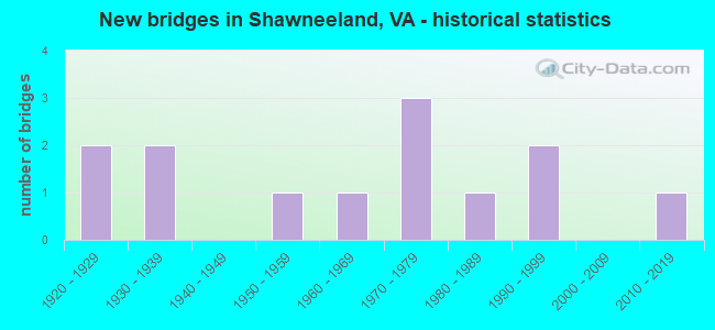
- New bridges - historical statistics
- 21920-1929
- 21930-1939
- 11950-1959
- 11960-1969
- 31970-1979
- 11980-1989
- 21990-1999
- 12010-2019

- Reconstructed bridges - Historical Statistics
- 11950-1959
- 01960-1969
- 11970-1979
- 01980-1989
- 01990-1999
- 12000-2009
- 12010-2019


- Bridge Condition - Deck
- 22.2%Very good
- 33.3%Satisfactory
- 33.3%Fair
- 11.1%Poor

- Bridge Condition - Superstructure
- 22.2%Very good
- 11.1%Good
- 33.3%Satisfactory
- 22.2%Fair
- 11.1%Poor

- Bridge Condition - Substructure
- 22.2%Very good
- 33.3%Good
- 22.2%Satisfactory
- 22.2%Fair

- Bridge Condition - Channel
- 53.8%Very good
- 15.4%Good
- 30.8%Satisfactory

- Bridge Condition - Culverts
- 75.0%Good
- 25.0%Satisfactory
Find on map >> Show street view
Structure Number: 8098, Location: 0.18 TO 614 - 0.27 TO 615 (Lat: 39.224875, Lng: -78.279508), Route carried "on" structure: US 50, Year Built: 1929, Status: Open, Structure Length: 2.53m (8.30ft), Average Daily Traffic: 5,930 (year 2020), Truck Traffic: 3%, Average Future Daily Traffic: 8,303 (year 2040), Design Load: HS 20+Mod, Features Intersected: HOGUE CREEK, Facility Carried by Structure: NORTHWESTRN PK-EBL
Minimum Vertical Clearance: 30+ m (98+ ft), Kilometerpoint: 14.280, Lanes on structure: 2, Base Highway Network: Yes, Owner: State Highway Agency, Approaching Roadway Width: 6.7m (22.0ft), Material/Design: Concrete, Design/Construction: Tee Beam, Number Of Spans In Main Unit: 3, Length of Maximum Span: 8.5m (27.9ft), Curb or Sidewalk Widths: Left: 0.2m (0.7ft), Right: 0.2m (0.7ft), Curb-To-Curb Width: 7.0m (23.0ft), Out-to-Out Width: 8.1m (26.6ft)
Condition: Deck: Satisfactory, Superstructure: Good, Substructure: Satisfactory, Channel: Very good, Operating Rating: 62.6 metric tons, Method Used To Determine Operating Rating: Load Factor (LF), Inventory Rating: 37.2 metric tons, Method Used To Determine Inventory Rating: Load Factor (LF), Structural Evaluation: Equal to present minimum criteria, Deck Geometry: High priority of replacement, Waterway Adequacy: Equal to present minimum criteria, Approach Roadway Alignment: Equal to present desirable criteria, Length Of Structure Improvement: 2.53m (8.30ft), Designated Inspection Frequency: Every 24 months, Inspection Date: March 2021, Bridge Improvement Cost: $118,000, Roadway Improvement Cost: $18,000, Total Project Cost: $137,000, Deck Structure Type: Concrete Cast-file-Place, Wearing Surface/Protective System: Wearing Surface: Epoxy Overlay
Find on map >> Show street view
Structure Number: 8105, Location: 0.18 TO 614 - 0.27 TO 615 (Lat: 39.225078, Lng: -78.279350), Route carried "on" structure: US 50, Year Built: 1962, Status: Open, Structure Length: 3.05m (10.01ft), Average Daily Traffic: 5,930 (year 2020), Truck Traffic: 3%, Average Future Daily Traffic: 8,303 (year 2040), Design Load: HS 20+Mod, Features Intersected: HOGUE CREEK, Facility Carried by Structure: NORTHWESTRN PK-WBL
Minimum Vertical Clearance: 30+ m (98+ ft), Kilometerpoint: 14.275, Lanes on structure: 2, Base Highway Network: Yes, Owner: State Highway Agency, Approaching Roadway Width: 7.3m (24.0ft), Material/Design: Concrete, Design/Construction: Tee Beam, Number Of Spans In Main Unit: 3, Length of Maximum Span: 10.1m (33.1ft), Curb or Sidewalk Widths: Left: 0.5m (1.6ft), Right: 0.5m (1.6ft), Curb-To-Curb Width: 9.1m (29.9ft), Out-to-Out Width: 10.1m (33.1ft)
Condition: Deck: Fair, Superstructure: Satisfactory, Substructure: Fair, Channel: Very good, Operating Rating: 57.2 metric tons, Method Used To Determine Operating Rating: Load and Resistance Factor (LRFR), Inventory Rating: 43.5 metric tons, Method Used To Determine Inventory Rating: Load and Resistance Factor (LRFR), Structural Evaluation: Somewhat better than minimum adequacy, Deck Geometry: Meets minimum limits, Waterway Adequacy: Equal to present minimum criteria, Approach Roadway Alignment: Better than present minimum criteria, Length Of Structure Improvement: 3.05m (10.01ft), Designated Inspection Frequency: Every 24 months, Inspection Date: October 2020, Bridge Improvement Cost: $120,000, Roadway Improvement Cost: $20,000, Total Project Cost: $141,000, Deck Structure Type: Concrete Cast-file-Place, Wearing Surface/Protective System: Wearing Surface: Latex Concrete
Find on map >> Show street view
Structure Number: 8186, Location: 1.60 TO 611 - 1.80 TO 607 (Lat: 39.142497, Lng: -78.379742), Route carried "on" structure: County highway 600, Year Built: 1953, Status: Open, Structure Length: 0.88m (2.89ft), Average Daily Traffic: 1,938 (year 2020), Truck Traffic: 3%, Average Future Daily Traffic: 2,713 (year 2040), Design Load: H 20, Features Intersected: PIFER RUN, Facility Carried by Structure: BACK MOUNTAIN RD
Minimum Vertical Clearance: 30+ m (98+ ft), Kilometerpoint: 17.345, Lanes on structure: 2, Owner: State Highway Agency, Approaching Roadway Width: 5.2m (17.1ft), Skew: 3 degrees, Material/Design: Concrete, Design/Construction: Culvert, Number Of Spans In Main Unit: 3, Length of Maximum Span: 2.4m (7.9ft)
Condition: Channel: Satisfactory, Culverts: Satisfactory, Operating Rating: 61.7 metric tons, Method Used To Determine Operating Rating: Allowable Stress (AS), Inventory Rating: 37.2 metric tons, Method Used To Determine Inventory Rating: Allowable Stress (AS), Structural Evaluation: Equal to present minimum criteria, Waterway Adequacy: Equal to present minimum criteria, Approach Roadway Alignment: Better than present minimum criteria, Designated Inspection Frequency: Every 24 months, Inspection Date: December 2021
Find on map >> Show street view
Structure Number: 8206, Location: 0.01 TO 50 - 2.00 TO 600 (Lat: 39.221783, Lng: -78.276972), Route carried "on" structure: County highway 614, Year Built: 1981, Status: Open, Structure Length: 1.22m (4.00ft), Average Daily Traffic: 4,928 (year 2020), Truck Traffic: 1%, Average Future Daily Traffic: 6,840 (year 2040), Design Load: HS 20+Mod, Features Intersected: GAP RUN, Facility Carried by Structure: BACK MOUNTAIN RD
Minimum Vertical Clearance: 30+ m (98+ ft), Kilometerpoint: 3.218, Lanes on structure: 2, Owner: State Highway Agency, Approaching Roadway Width: 7.0m (23.0ft), Material/Design: Prestressed concrete, Design/Construction: Slab, Number Of Spans In Main Unit: 1, Length of Maximum Span: 11.6m (38.1ft), Curb-To-Curb Width: 9.1m (29.9ft), Out-to-Out Width: 10.1m (33.1ft)
Condition: Deck: Poor, Superstructure: Poor, Substructure: Very good, Channel: Satisfactory, Operating Rating: 70.8 metric tons, Method Used To Determine Operating Rating: Load and Resistance Factor (LRFR), Inventory Rating: 54.4 metric tons, Method Used To Determine Inventory Rating: Load and Resistance Factor (LRFR), Structural Evaluation: Meets minimum limits, Deck Geometry: Meets minimum limits, Waterway Adequacy: Equal to present minimum criteria, Approach Roadway Alignment: Better than present minimum criteria, Designated Inspection Frequency: Every 12 months, Inspection Date: May 2021, Deck Structure Type: Other, Wearing Surface/Protective System: Wearing Surface: Epoxy Overlay
Find on map >> Show street view
Structure Number: 8207, Location: 0.80 TO 50 - 1.24 TO 600 (Lat: 39.214981, Lng: -78.288272), Route carried "on" structure: County highway 614, Year Built: 1932, Year Reconstructed: 1959, Status: Open, Structure Length: 2.26m (7.41ft), Average Daily Traffic: 4,928 (year 2020), Truck Traffic: 1%, Average Future Daily Traffic: 6,840 (year 2040), Design Load: HS 15, Features Intersected: HOGUE CREEK, Facility Carried by Structure: BACK MOUNTAIN RD
Minimum Vertical Clearance: 30+ m (98+ ft), Kilometerpoint: 1.995, Lanes on structure: 2, Owner: State Highway Agency, Approaching Roadway Width: 6.7m (22.0ft), Material/Design: Prestressed concrete, Design/Construction: Box Beam or Girders - Multiple, Number Of Spans In Main Unit: 1, Length of Maximum Span: 21.6m (70.9ft), Curb or Sidewalk Widths: Left: 0.5m (1.6ft), Right: 0.5m (1.6ft), Curb-To-Curb Width: 7.3m (24.0ft), Out-to-Out Width: 8.2m (26.9ft)
Condition: Deck: Satisfactory, Superstructure: Satisfactory, Substructure: Satisfactory, Channel: Very good, Operating Rating: 64.4 metric tons, Method Used To Determine Operating Rating: Load and Resistance Factor (LRFR), Inventory Rating: 28.1 metric tons, Method Used To Determine Inventory Rating: Load and Resistance Factor (LRFR), Structural Evaluation: Equal to present minimum criteria, Deck Geometry: High priority of replacement, Waterway Adequacy: Better than present minimum criteria, Approach Roadway Alignment: Equal to present minimum criteria, Length Of Structure Improvement: 2.26m (7.41ft), Designated Inspection Frequency: Every 24 months, Inspection Date: March 2020, Bridge Improvement Cost: $67,000, Roadway Improvement Cost: $7,000, Total Project Cost: $75,000, Deck Structure Type: Other, Wearing Surface/Protective System: Wearing Surface: Bituminous, Membrane: Epoxy
Find on map >> Show street view
Structure Number: 8231, Location: 0.10 TO 704 - 0.30 TO END (Lat: 39.260322, Lng: -78.333664), Route carried "on" structure: County highway 632, Year Built: 1975, Status: Open, Structure Length: 1.83m (6.00ft), Average Daily Traffic: 642 (year 2020), Average Future Daily Traffic: 899 (year 2040), Design Load: HS 20+Mod, Features Intersected: BACK CREEK, Facility Carried by Structure: SANDMINE RD
Minimum Vertical Clearance: 30+ m (98+ ft), Kilometerpoint: 0.481, Lanes on structure: 2, Owner: State Highway Agency, Approaching Roadway Width: 6.7m (22.0ft), Material/Design: Prestressed concrete, Design/Construction: Box Beam or Girders - Multiple, Number Of Spans In Main Unit: 1, Length of Maximum Span: 17.7m (58.1ft), Curb-To-Curb Width: 9.1m (29.9ft), Out-to-Out Width: 10.0m (32.8ft)
Condition: Deck: Satisfactory, Superstructure: Satisfactory, Substructure: Good, Channel: Very good, Operating Rating: 54.4 metric tons, Method Used To Determine Operating Rating: Load and Resistance Factor (LRFR), Inventory Rating: 41.7 metric tons, Method Used To Determine Inventory Rating: Load and Resistance Factor (LRFR), Structural Evaluation: Equal to present minimum criteria, Deck Geometry: Equal to present minimum criteria, Waterway Adequacy: Better than present minimum criteria, Approach Roadway Alignment: Equal to present minimum criteria, Designated Inspection Frequency: Every 24 months, Inspection Date: March 2020, Deck Structure Type: Other, Wearing Surface/Protective System: Wearing Surface: Bituminous, Membrane: Preformed Fabric
Find on map >> Show street view
Structure Number: 829, Location: 3.30 TO 632 - 1.05 TO 683 (Lat: 39.231231, Lng: -78.374969), Route carried "on" structure: County highway 704, Year Built: 1932, Year Reconstructed: 2014, Status: Open, Structure Length: 1.55m (5.09ft), Average Daily Traffic: 423 (year 2017), Average Future Daily Traffic: 499 (year 2040), Design Load: HS 20+Mod, Features Intersected: BACK CREEK, Facility Carried by Structure: BACK CREEK RD
Minimum Vertical Clearance: 30+ m (98+ ft), Kilometerpoint: 6.985, Lanes on structure: 2, Owner: State Highway Agency, Approaching Roadway Width: 5.5m (18.0ft), Material/Design: Prestressed concrete, Design/Construction: Slab, Number Of Spans In Main Unit: 1, Length of Maximum Span: 15.5m (50.9ft), Curb-To-Curb Width: 8.1m (26.6ft), Out-to-Out Width: 8.2m (26.9ft)
Condition: Deck: Very good, Superstructure: Very good, Substructure: Good, Channel: Very good, Operating Rating: 71.7 metric tons, Method Used To Determine Operating Rating: Load and Resistance Factor (LRFR), Inventory Rating: 55.3 metric tons, Method Used To Determine Inventory Rating: Load and Resistance Factor (LRFR), Structural Evaluation: Better than present minimum criteria, Deck Geometry: Somewhat better than minimum adequacy, Waterway Adequacy: Equal to present minimum criteria, Approach Roadway Alignment: Somewhat better than minimum adequacy, Designated Inspection Frequency: Every 24 months, Inspection Date: November 2020, Deck Structure Type: Other, Wearing Surface/Protective System: Wearing Surface: Bituminous, Membrane: Epoxy
Find on map >> Show street view
Structure Number: 8291, Location: 1.48 TO 617 - 0.19 TO 683 (Lat: 39.217567, Lng: -78.388922), Route carried "on" structure: County highway 704, Year Built: 1927, Year Reconstructed: 1983, Status: Open, Structure Length: 0.94m (3.08ft), Average Daily Traffic: 225 (year 2020), Average Future Daily Traffic: 261 (year 2040), Features Intersected: BACK CREEK, Facility Carried by Structure: BACK CREEK RD
Minimum Vertical Clearance: 30+ m (98+ ft), Kilometerpoint: 4.996, Lanes on structure: 2, Owner: State Highway Agency, Approaching Roadway Width: 4.3m (14.1ft), Material/Design: Concrete, Design/Construction: Slab, Number Of Spans In Main Unit: 2, Length of Maximum Span: 4.6m (15.1ft), Curb-To-Curb Width: 5.8m (19.0ft), Out-to-Out Width: 6.5m (21.3ft)
Condition: Deck: Fair, Superstructure: Fair, Substructure: Good, Channel: Good, Operating Rating: 53.5 metric tons, Method Used To Determine Operating Rating: Load and Resistance Factor (LRFR), Inventory Rating: 41.2 metric tons, Method Used To Determine Inventory Rating: Load and Resistance Factor (LRFR), Structural Evaluation: Somewhat better than minimum adequacy, Deck Geometry: High priority of corrective action, Waterway Adequacy: Equal to present minimum criteria, Approach Roadway Alignment: Meets minimum limits, Length Of Structure Improvement: 0.94m (3.08ft), Designated Inspection Frequency: Every 24 months, Inspection Date: May 2020, Bridge Improvement Cost: $20,000, Roadway Improvement Cost: $5,000, Total Project Cost: $26,000, Deck Structure Type: Concrete Cast-file-Place, Wearing Surface/Protective System: Wearing Surface: Bituminous
Find on map >> Show street view
Structure Number: 8309, Location: 0.43 END MAINT-0.01 TO817 (Lat: 39.207000, Lng: -78.263903), Route carried "on" structure: County highway 809, Year Built: 1971, Year Reconstructed: 2018, Status: Open, Structure Length: 0.79m (2.59ft), Average Daily Traffic: 50 (year 2017), Average Future Daily Traffic: 73 (year 2040), Features Intersected: GAP RUN, Facility Carried by Structure: MCFARLAND RD
Minimum Vertical Clearance: 30+ m (98+ ft), Kilometerpoint: 0.700, Lanes on structure: 2, Owner: State Highway Agency, Approaching Roadway Width: 5.5m (18.0ft), Material/Design: Prestressed concrete, Design/Construction: Slab, Number Of Spans In Main Unit: 1, Length of Maximum Span: 7.3m (24.0ft), Curb-To-Curb Width: 6.8m (22.3ft), Out-to-Out Width: 6.9m (22.6ft)
Condition: Deck: Very good, Superstructure: Very good, Substructure: Very good, Channel: Very good, Operating Rating: 53.5 metric tons, Method Used To Determine Operating Rating: Load and Resistance Factor (LRFR), Inventory Rating: 40.8 metric tons, Method Used To Determine Inventory Rating: Load and Resistance Factor (LRFR), Structural Evaluation: Equal to present desirable criteria, Deck Geometry: Somewhat better than minimum adequacy, Waterway Adequacy: Equal to present minimum criteria, Approach Roadway Alignment: Equal to present minimum criteria, Designated Inspection Frequency: Every 24 months, Inspection Date: May 2020, Deck Structure Type: Other, Wearing Surface/Protective System: Wearing Surface: Epoxy Overlay, Deck Protection: Other Coated Reinforcing
Find on map >> Show street view
Structure Number: 8311, Location: 0.25 TO 751 - 0.25 TO END (Lat: 39.261472, Lng: -78.328192), Route carried "on" structure: County highway 853, Year Built: 1972, Status: Posted for load, Structure Length: 1.95m (6.40ft), Average Daily Traffic: 296 (year 2014), Average Future Daily Traffic: 327 (year 2040), Design Load: HS 20, Features Intersected: BACK CREEK, Facility Carried by Structure: SINKING SPRINGS LN
Minimum Vertical Clearance: 30+ m (98+ ft), Kilometerpoint: 0.383, Lanes on structure: 2, Owner: State Highway Agency, Approaching Roadway Width: 4.9m (16.1ft), Material/Design: Steel, Design/Construction: Stringer/Multi-beam, Number Of Spans In Main Unit: 2, Length of Maximum Span: 11.9m (39.0ft), Curb or Sidewalk Widths: Left: 0.2m (0.7ft), Right: 0.2m (0.7ft), Curb-To-Curb Width: 5.8m (19.0ft), Out-to-Out Width: 6.1m (20.0ft)
Condition: Deck: Fair, Superstructure: Fair, Substructure: Fair, Channel: Satisfactory, Operating Rating: 35.4 metric tons, Method Used To Determine Operating Rating: Load Factor (LF), Inventory Rating: 20.9 metric tons, Method Used To Determine Inventory Rating: Load Factor (LF), Structural Evaluation: Somewhat better than minimum adequacy, Deck Geometry: High priority of corrective action, Waterway Adequacy: Somewhat better than minimum adequacy, Approach Roadway Alignment: Equal to present minimum criteria, Bridge Posting: Required (Relationship of Operating Rating to Maximum Legal Load: > 39.9% below), Length Of Structure Improvement: 1.95m (6.40ft), Designated Inspection Frequency: Every 24 months, Inspection Date: March 2021, Bridge Improvement Cost: $75,000, Roadway Improvement Cost: $7,000, Total Project Cost: $83,000, Deck Structure Type: Wood or Timber, Wearing Surface/Protective System: Wearing Surface: Bituminous
Find on map >> Show street view
Structure Number: 24115, Location: 1.05 TO 753 - 0.15 TO 612 (Lat: 39.177422, Lng: -78.340417), Route carried "on" structure: County highway 600, Year Built: 1994, Status: Open, Structure Length: 0.64m (2.10ft), Average Daily Traffic: 4,134 (year 2020), Truck Traffic: 3%, Average Future Daily Traffic: 5,788 (year 2040), Design Load: HS 20+Mod, Features Intersected: TRIB HOGUE CREEK, Facility Carried by Structure: BACK MOUNTAIN RD
Minimum Vertical Clearance: 30+ m (98+ ft), Kilometerpoint: 23.121, Lanes on structure: 2, Owner: State Highway Agency, Approaching Roadway Width: 5.5m (18.0ft), Skew: 2 degrees, Material/Design: Concrete, Design/Construction: Culvert, Number Of Spans In Main Unit: 2, Length of Maximum Span: 2.7m (8.9ft)
Condition: Channel: Good, Culverts: Good, Operating Rating: 50.8 metric tons, Method Used To Determine Operating Rating: Field evaluation and documented engineering judgment, Inventory Rating: 29.9 metric tons, Method Used To Determine Inventory Rating: Field evaluation and documented engineering judgment, Structural Evaluation: Better than present minimum criteria, Waterway Adequacy: Equal to present minimum criteria, Approach Roadway Alignment: Equal to present desirable criteria, Designated Inspection Frequency: Every 24 months, Inspection Date: March 2021
Find on map >> Show street view
Structure Number: 24624, Location: 1.90 TO 629 - 2.31 TO 600 (Lat: 39.136289, Lng: -78.364194), Route carried "on" structure: County highway 608, Year Built: 1996, Status: Open, Structure Length: 1.22m (4.00ft), Average Daily Traffic: 175 (year 2020), Truck Traffic: 4%, Average Future Daily Traffic: 191 (year 2040), Design Load: HS 20, Features Intersected: FURNACE RUN, Facility Carried by Structure: WARDENSVILLE PIKE
Minimum Vertical Clearance: 30+ m (98+ ft), Kilometerpoint: 8.978, Lanes on structure: 2, Owner: State Highway Agency, Approaching Roadway Width: 4.6m (15.1ft), Material/Design: Concrete, Design/Construction: Culvert, Number Of Spans In Main Unit: 3, Length of Maximum Span: 3.7m (12.1ft)
Condition: Channel: Satisfactory, Culverts: Good, Operating Rating: 54.4 metric tons, Method Used To Determine Operating Rating: Field evaluation and documented engineering judgment, Inventory Rating: 32.7 metric tons, Method Used To Determine Inventory Rating: Field evaluation and documented engineering judgment, Structural Evaluation: Better than present minimum criteria, Waterway Adequacy: Equal to present minimum criteria, Approach Roadway Alignment: Equal to present minimum criteria, Designated Inspection Frequency: Every 24 months, Inspection Date: October 2020
Find on map >> Show street view
Structure Number: 30655, Location: 0.21 TO 617-1.30WV LINE (Lat: 39.201275, Lng: -78.411267), Route carried "on" structure: County highway 704, Year Built: 2015, Status: Open, Structure Length: 0.67m (2.20ft), Average Daily Traffic: 114 (year 2020), Average Future Daily Traffic: 160 (year 2040), Design Load: HS 20+Mod, Features Intersected: BACK CREEK, Facility Carried by Structure: BACK CREEK ROAD
Minimum Vertical Clearance: 30+ m (98+ ft), Kilometerpoint: 2.231, Lanes on structure: 2, Owner: State Highway Agency, Approaching Roadway Width: 3.7m (12.1ft), Skew: 3 degrees, Material/Design: Concrete, Design/Construction: Culvert, Number Of Spans In Main Unit: 1, Length of Maximum Span: 2.4m (7.9ft), Curb-To-Curb Width: 6.7m (22.0ft), Out-to-Out Width: 6.7m (22.0ft)
Condition: Channel: Very good, Culverts: Good, Operating Rating: 44.5 metric tons, Method Used To Determine Operating Rating: Field evaluation and documented engineering judgment, Inventory Rating: 32.7 metric tons, Method Used To Determine Inventory Rating: Field evaluation and documented engineering judgment, Structural Evaluation: Better than present minimum criteria, Deck Geometry: Meets minimum limits, Approach Roadway Alignment: Equal to present minimum criteria, Designated Inspection Frequency: Every 24 months, Inspection Date: July 2021