Bridge Statistics for Shelby, Montana (MT)
Condition, Traffic, Stress, Structural Evaluation, Project Costs
- National Bridge Inventory (NBI) Statistics
- 23Number of bridges
- 430ft / 131mTotal length
- $2,544,000Total costs
- 33,382Total average daily traffic
- 8,821Total average daily truck traffic
- National Bridge Inventory (NBI) Registered Bridges for Shelby
- No street view available for this location
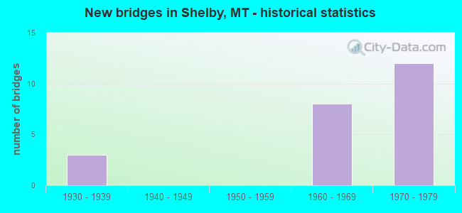
- New bridges - historical statistics
- 31930-1939
- 81960-1969
- 121970-1979


- Bridge Condition - Deck
- 30.8%Very good
- 23.1%Good
- 38.5%Satisfactory
- 7.7%Fair

- Bridge Condition - Superstructure
- 53.8%Very good
- 46.2%Satisfactory

- Bridge Condition - Substructure
- 61.5%Good
- 30.8%Satisfactory
- 7.7%Fair

- Bridge Condition - Channel
- 66.7%Good
- 33.3%Satisfactory
Find on map >> Show street view
Structure Number: I00015357+00751, Location: 6M S SHELBY (Lat: 48.427228, Lng: -111.891347), Route carried "on" structure: Interstate 15, Year Built: 1976, Status: Open, Structure Length: 14.75m (48.39ft), Average Daily Traffic: 2,807 (year 2020), Truck Traffic: 28%, Average Future Daily Traffic: 2,947 (year 2040), Design Load: HS 20, Features Intersected: MARIAS RIVER
Minimum Vertical Clearance: 30+ m (98+ ft), Kilometerpoint: 572.013, Lanes on structure: 2, Base Highway Network: Yes, Owner: State Highway Agency, Approaching Roadway Width: 12.6m (41.3ft), Material/Design: Prestressed concrete, Design/Construction: Stringer/Multi-beam, Number Of Spans In Main Unit: 5, Length of Maximum Span: 38.6m (126.6ft), Curb or Sidewalk Widths: Left: 0.1m (0.3ft), Right: 0.1m (0.3ft), Curb-To-Curb Width: 12.6m (41.3ft), Out-to-Out Width: 13.5m (44.3ft)
Condition: Deck: Satisfactory, Superstructure: Very good, Substructure: Good, Channel: Good, Operating Rating: 46.3 metric tons, Method Used To Determine Operating Rating: Load and Resistance Factor (LRFR), Inventory Rating: 28.1 metric tons, Method Used To Determine Inventory Rating: Load and Resistance Factor (LRFR), Structural Evaluation: Better than present minimum criteria, Deck Geometry: Better than present minimum criteria, Waterway Adequacy: Better than present minimum criteria, Approach Roadway Alignment: Equal to present desirable criteria, Designated Inspection Frequency: Every 24 months, Inspection Date: August 2021, Deck Structure Type: Concrete Cast-file-Place, Wearing Surface/Protective System: Wearing Surface: Monolithic Concrete
Find on map >> Show street view
Structure Number: I00015357+00752, Location: 6M S SHELBY (Lat: 48.427333, Lng: -111.891578), Route carried "on" structure: Interstate 15, Year Built: 1976, Status: Open, Structure Length: 14.75m (48.39ft), Average Daily Traffic: 2,807 (year 2020), Truck Traffic: 28%, Average Future Daily Traffic: 2,947 (year 2040), Design Load: HS 20, Features Intersected: MARIAS RIVER
Minimum Vertical Clearance: 30+ m (98+ ft), Kilometerpoint: 571.713, Lanes on structure: 2, Base Highway Network: Yes, Owner: State Highway Agency, Approaching Roadway Width: 12.6m (41.3ft), Material/Design: Prestressed concrete, Design/Construction: Stringer/Multi-beam, Number Of Spans In Main Unit: 5, Length of Maximum Span: 38.6m (126.6ft), Curb or Sidewalk Widths: Left: 0.1m (0.3ft), Right: 0.1m (0.3ft), Curb-To-Curb Width: 12.6m (41.3ft), Out-to-Out Width: 13.5m (44.3ft)
Condition: Deck: Satisfactory, Superstructure: Very good, Substructure: Good, Channel: Good, Operating Rating: 46.3 metric tons, Method Used To Determine Operating Rating: Load and Resistance Factor (LRFR), Inventory Rating: 28.1 metric tons, Method Used To Determine Inventory Rating: Load and Resistance Factor (LRFR), Structural Evaluation: Better than present minimum criteria, Deck Geometry: Better than present minimum criteria, Waterway Adequacy: Better than present minimum criteria, Approach Roadway Alignment: Equal to present desirable criteria, Designated Inspection Frequency: Every 24 months, Inspection Date: August 2021, Deck Structure Type: Concrete Cast-file-Place, Wearing Surface/Protective System: Wearing Surface: Monolithic Concrete
Find on map >> Show street view
Structure Number: I00015362+01851, Location: 1M S SHELBY (Lat: 48.499883, Lng: -111.883211), Route carried "on" structure: Interstate 15, Year Built: 1976, Status: Open, Structure Length: 2.35m (7.71ft), Average Daily Traffic: 2,275 (year 2020), Truck Traffic: 35%, Average Future Daily Traffic: 2,389 (year 2040), Design Load: HS 20, Features Intersected: SEP COUNTY ROAD
Minimum Vertical Clearance: 30+ m (98+ ft), Kilometerpoint: 580.347, Lanes on structure: 2, Lanes under structure: 2, Base Highway Network: Yes, Owner: State Highway Agency, Approaching Roadway Width: 12.6m (41.3ft), Material/Design: Prestressed concrete, Design/Construction: Stringer/Multi-beam, Number Of Spans In Main Unit: 1, Length of Maximum Span: 22.9m (75.1ft), Curb or Sidewalk Widths: Left: 0.1m (0.3ft), Right: 0.1m (0.3ft), Curb-To-Curb Width: 12.6m (41.3ft), Out-to-Out Width: 13.5m (44.3ft)
Condition: Deck: Satisfactory, Superstructure: Very good, Substructure: Satisfactory, Operating Rating: 65.2 metric tons, Method Used To Determine Operating Rating: Load Factor (LF), Inventory Rating: 41.0 metric tons, Method Used To Determine Inventory Rating: Load Factor (LF), Structural Evaluation: Equal to present minimum criteria, Deck Geometry: Better than present minimum criteria, Underclear: Better than present minimum criteria, Approach Roadway Alignment: Equal to present desirable criteria, Designated Inspection Frequency: Every 48 months, Inspection Date: August 2020, Deck Structure Type: Concrete Cast-file-Place, Wearing Surface/Protective System: Wearing Surface: Monolithic Concrete
Find on map >> Show street view
Structure Number: I00015362+01852, Location: 1M S SHELBY (Lat: 48.499878, Lng: -111.883650), Route carried "on" structure: Interstate 15, Year Built: 1976, Status: Open, Structure Length: 2.29m (7.51ft), Average Daily Traffic: 2,275 (year 2020), Truck Traffic: 35%, Average Future Daily Traffic: 2,389 (year 2040), Design Load: HS 20, Features Intersected: SEP COUNTY ROAD
Minimum Vertical Clearance: 30+ m (98+ ft), Kilometerpoint: 580.029, Lanes on structure: 2, Lanes under structure: 2, Base Highway Network: Yes, Owner: State Highway Agency, Approaching Roadway Width: 12.6m (41.3ft), Material/Design: Prestressed concrete, Design/Construction: Stringer/Multi-beam, Number Of Spans In Main Unit: 1, Length of Maximum Span: 22.9m (75.1ft), Curb or Sidewalk Widths: Left: 0.1m (0.3ft), Right: 0.1m (0.3ft), Curb-To-Curb Width: 12.6m (41.3ft), Out-to-Out Width: 13.5m (44.3ft)
Condition: Deck: Satisfactory, Superstructure: Very good, Substructure: Satisfactory, Operating Rating: 61.7 metric tons, Method Used To Determine Operating Rating: Load Factor (LF), Inventory Rating: 41.0 metric tons, Method Used To Determine Inventory Rating: Load Factor (LF), Structural Evaluation: Equal to present minimum criteria, Deck Geometry: Better than present minimum criteria, Underclear: Superior to present desirable criteria, Approach Roadway Alignment: Equal to present desirable criteria, Designated Inspection Frequency: Every 48 months, Inspection Date: August 2020, Deck Structure Type: Concrete Cast-file-Place, Wearing Surface/Protective System: Wearing Surface: Monolithic Concrete
Find on map >> Show street view
Structure Number: I00015363+04831, Location: SHELBY (Lat: 48.515672, Lng: -111.876133), Route carried "on" structure: Interstate 15, Year Built: 1960, Status: Open, Structure Length: 13.07m (42.88ft), Average Daily Traffic: 2,245 (year 2020), Truck Traffic: 32%, Average Future Daily Traffic: 2,357 (year 2040), Design Load: HS 20, Features Intersected: INT SHELBY-RR
Minimum Vertical Clearance: 30+ m (98+ ft), Kilometerpoint: 582.225, Lanes on structure: 2, Lanes under structure: 4, Base Highway Network: Yes, Owner: State Highway Agency, Approaching Roadway Width: 12.2m (40.0ft), Material/Design: Steel, Design/Construction: Stringer/Multi-beam, Number Of Spans In Main Unit: 2, Number Of Approach Spans: 6, Length of Maximum Span: 20.6m (67.6ft), Curb-To-Curb Width: 12.2m (40.0ft), Out-to-Out Width: 13.4m (44.0ft)
Condition: Deck: Very good, Superstructure: Satisfactory, Substructure: Good, Operating Rating: 54.4 metric tons, Method Used To Determine Operating Rating: Load Factor (LF), Inventory Rating: 32.7 metric tons, Method Used To Determine Inventory Rating: Load Factor (LF), Structural Evaluation: Equal to present minimum criteria, Deck Geometry: Better than present minimum criteria, Underclear: Equal to present minimum criteria, Approach Roadway Alignment: Equal to present desirable criteria, Designated Inspection Frequency: Every 24 months, Inspection Date: August 2020, Deck Structure Type: Concrete Cast-file-Place, Wearing Surface/Protective System: Wearing Surface: Latex Concrete
Find on map >> Show street view
Structure Number: I00015363+04832, Location: SHELBY (Lat: 48.515778, Lng: -111.876456), Route carried "on" structure: Interstate 15, Year Built: 1960, Status: Open, Structure Length: 13.07m (42.88ft), Average Daily Traffic: 2,275 (year 2020), Truck Traffic: 35%, Average Future Daily Traffic: 2,389 (year 2040), Design Load: HS 20, Features Intersected: INT SHELBY-RR
Minimum Vertical Clearance: 30+ m (98+ ft), Kilometerpoint: 581.920, Lanes on structure: 2, Lanes under structure: 4, Base Highway Network: Yes, Owner: State Highway Agency, Approaching Roadway Width: 12.2m (40.0ft), Material/Design: Steel, Design/Construction: Stringer/Multi-beam, Number Of Spans In Main Unit: 2, Number Of Approach Spans: 6, Length of Maximum Span: 20.6m (67.6ft), Curb-To-Curb Width: 8.5m (27.9ft), Out-to-Out Width: 9.7m (31.8ft)
Condition: Deck: Very good, Superstructure: Satisfactory, Substructure: Good, Operating Rating: 50.8 metric tons, Method Used To Determine Operating Rating: Load Factor (LF), Inventory Rating: 30.8 metric tons, Method Used To Determine Inventory Rating: Load Factor (LF), Structural Evaluation: Equal to present minimum criteria, Deck Geometry: High priority of corrective action, Underclear: Equal to present minimum criteria, Approach Roadway Alignment: Better than present minimum criteria, Designated Inspection Frequency: Every 24 months, Inspection Date: August 2020, Bridge Improvement Cost: $814,000, Roadway Improvement Cost: $81,000, Total Project Cost: $895,000, Deck Structure Type: Concrete Cast-file-Place, Wearing Surface/Protective System: Wearing Surface: Latex Concrete
Find on map >> Show street view
Structure Number: L37115000+05001, Location: 9M SW SHELBY (Lat: 48.365114, Lng: -111.935739), Route carried "on" structure: Spur County highway 37115, Year Built: 1976, Status: Open, Structure Length: 8.78m (28.81ft), Average Daily Traffic: 100 (year 2022), Truck Traffic: 3%, Average Future Daily Traffic: 100 (year 2037), Design Load: HS 20, Features Intersected: INT BULLHEAD RD-I 15 008, Facility Carried by Structure: WESTRIDGE RD
Minimum Vertical Clearance: 30+ m (98+ ft), Kilometerpoint: 0.880, Lanes on structure: 2, Lanes under structure: 4, Owner: State Highway Agency, Approaching Roadway Width: 9.6m (31.5ft), Material/Design: Prestressed concrete, Design/Construction: Stringer/Multi-beam, Number Of Spans In Main Unit: 4, Length of Maximum Span: 30.9m (101.4ft), Curb-To-Curb Width: 9.6m (31.5ft), Out-to-Out Width: 10.4m (34.1ft)
Condition: Deck: Very good, Superstructure: Very good, Substructure: Good, Operating Rating: 47.2 metric tons, Method Used To Determine Operating Rating: Load and Resistance Factor (LRFR), Inventory Rating: 24.5 metric tons, Method Used To Determine Inventory Rating: Load and Resistance Factor (LRFR), Structural Evaluation: Equal to present minimum criteria, Deck Geometry: Better than present minimum criteria, Underclear: Superior to present desirable criteria, Approach Roadway Alignment: Better than present minimum criteria, Designated Inspection Frequency: Every 24 months, Inspection Date: December 2021, Deck Structure Type: Concrete Cast-file-Place, Wearing Surface/Protective System: Wearing Surface: Monolithic Concrete
Find on map >> Show street view
Structure Number: L51012000+02001, Location: 5M N SHELBY (Lat: 48.595364, Lng: -111.861847), Route carried "on" structure: Spur County highway 51012, Year Built: 1964, Year Reconstructed: 1980, Status: Open, Structure Length: 7.50m (24.61ft), Average Daily Traffic: 100 (year 2022), Truck Traffic: 3%, Average Future Daily Traffic: 100 (year 2037), Design Load: HL 93, Features Intersected: INT BRONKEN RD I 15 003, Facility Carried by Structure: BRONKEN RD
Minimum Vertical Clearance: 30+ m (98+ ft), Kilometerpoint: 0.252, Lanes on structure: 2, Lanes under structure: 4, Owner: State Highway Agency, Approaching Roadway Width: 8.5m (27.9ft), Material/Design: Prestressed concrete, Design/Construction: Stringer/Multi-beam, Number Of Spans In Main Unit: 4, Length of Maximum Span: 23.3m (76.4ft), Curb or Sidewalk Widths: Left: 0.1m (0.3ft), Right: 0.1m (0.3ft), Curb-To-Curb Width: 8.5m (27.9ft), Out-to-Out Width: 9.5m (31.2ft)
Condition: Deck: Very good, Superstructure: Very good, Substructure: Good, Operating Rating: 47.2 metric tons, Method Used To Determine Operating Rating: Load and Resistance Factor (LRFR), Inventory Rating: 24.5 metric tons, Method Used To Determine Inventory Rating: Load and Resistance Factor (LRFR), Structural Evaluation: Equal to present minimum criteria, Deck Geometry: Better than present minimum criteria, Underclear: Equal to present minimum criteria, Approach Roadway Alignment: Better than present minimum criteria, Designated Inspection Frequency: Every 24 months, Inspection Date: June 2020, Deck Structure Type: Concrete Cast-file-Place, Wearing Surface/Protective System: Wearing Surface: Monolithic Concrete
Find on map >> Show street view
Structure Number: L51172000+03001, Location: 3M S SHELBY (Lat: 48.450914, Lng: -111.883817), Route carried "on" structure: Spur County highway 51172, Year Built: 1976, Status: Open, Structure Length: 8.74m (28.67ft), Average Daily Traffic: 100 (year 2022), Truck Traffic: 3%, Average Future Daily Traffic: 100 (year 2037), Design Load: HS 20, Features Intersected: INT MARIAS VALLEY RD 007, Facility Carried by Structure: LINCOLN RD
Minimum Vertical Clearance: 30+ m (98+ ft), Kilometerpoint: 0.257, Lanes on structure: 2, Lanes under structure: 4, Owner: State Highway Agency, Approaching Roadway Width: 9.1m (29.9ft), Material/Design: Prestressed concrete, Design/Construction: Stringer/Multi-beam, Number Of Spans In Main Unit: 4, Length of Maximum Span: 32.5m (106.6ft), Curb or Sidewalk Widths: Left: 0.1m (0.3ft), Right: 0.1m (0.3ft), Curb-To-Curb Width: 9.0m (29.5ft), Out-to-Out Width: 9.8m (32.2ft)
Condition: Deck: Good, Superstructure: Satisfactory, Substructure: Good, Operating Rating: 74.1 metric tons, Method Used To Determine Operating Rating: Load Factor (LF), Inventory Rating: 35.6 metric tons, Method Used To Determine Inventory Rating: Load Factor (LF), Structural Evaluation: Equal to present minimum criteria, Deck Geometry: Better than present minimum criteria, Underclear: Superior to present desirable criteria, Approach Roadway Alignment: Equal to present minimum criteria, Designated Inspection Frequency: Every 24 months, Inspection Date: September 2021, Deck Structure Type: Concrete Cast-file-Place, Wearing Surface/Protective System: Wearing Surface: Monolithic Concrete
Find on map >> Show street view
Structure Number: L51306000+09001, Location: 7M S SHELBY (Lat: 48.397208, Lng: -111.917731), Route carried "on" structure: Spur State highway 81007, Year Built: 1976, Status: Open, Structure Length: 9.01m (29.56ft), Average Daily Traffic: 100 (year 2022), Truck Traffic: 3%, Average Future Daily Traffic: 100 (year 2037), Design Load: HS 20, Features Intersected: SEP I 15 010, Facility Carried by Structure: MARIAS VALLEY RD
Minimum Vertical Clearance: 30+ m (98+ ft), Kilometerpoint: 25.487, Lanes on structure: 2, Lanes under structure: 4, Owner: State Highway Agency, Approaching Roadway Width: 9.7m (31.8ft), Material/Design: Prestressed concrete, Design/Construction: Stringer/Multi-beam, Number Of Spans In Main Unit: 4, Length of Maximum Span: 32.0m (105.0ft), Curb or Sidewalk Widths: Left: 0.1m (0.3ft), Right: 0.1m (0.3ft), Curb-To-Curb Width: 9.6m (31.5ft), Out-to-Out Width: 10.4m (34.1ft)
Condition: Deck: Good, Superstructure: Very good, Substructure: Satisfactory, Operating Rating: 45.4 metric tons, Method Used To Determine Operating Rating: Load and Resistance Factor (LRFR), Inventory Rating: 19.1 metric tons, Method Used To Determine Inventory Rating: Load and Resistance Factor (LRFR), Structural Evaluation: Somewhat better than minimum adequacy, Deck Geometry: Better than present minimum criteria, Underclear: Superior to present desirable criteria, Approach Roadway Alignment: Equal to present minimum criteria, Designated Inspection Frequency: Every 24 months, Inspection Date: September 2021, Deck Structure Type: Concrete Cast-file-Place, Wearing Surface/Protective System: Wearing Surface: Monolithic Concrete
Find on map >> Show street view
Structure Number: L51306003+02001, Location: 5M S SHELBY (Lat: 48.427011, Lng: -111.891006), Route carried "on" structure: Spur State highway 81007, Year Built: 1936, Status: Open, Structure Length: 16.61m (54.49ft), Average Daily Traffic: 100 (year 2022), Truck Traffic: 3%, Average Future Daily Traffic: 100 (year 2037), Design Load: H 15, Features Intersected: MARIAS RIVER 001, Facility Carried by Structure: MARIAS VALLEY RD
Minimum Vertical Clearance: 30+ m (98+ ft), Kilometerpoint: 29.806, Lanes on structure: 2, Owner: State Highway Agency, Approaching Roadway Width: 7.3m (24.0ft), Material/Design: Steel continuous, Design/Construction: Girder and Floorbeam System, Number Of Spans In Main Unit: 2, Number Of Approach Spans: 4, Length of Maximum Span: 36.7m (120.4ft), Curb-To-Curb Width: 7.3m (24.0ft), Out-to-Out Width: 8.3m (27.2ft)
Condition: Deck: Fair, Superstructure: Satisfactory, Substructure: Fair, Channel: Satisfactory, Operating Rating: 43.5 metric tons, Method Used To Determine Operating Rating: Load Factor (LF), Inventory Rating: 26.3 metric tons, Method Used To Determine Inventory Rating: Load Factor (LF), Structural Evaluation: Somewhat better than minimum adequacy, Deck Geometry: Equal to present minimum criteria, Waterway Adequacy: Better than present minimum criteria, Approach Roadway Alignment: Better than present minimum criteria, Designated Inspection Frequency: Every 24 months, Critical Feature Inspection Frequency: Every 24 months, Inspection Date: September 2021, Critical Feature Inspection Date: September 2021, Deck Structure Type: Concrete Cast-file-Place, Wearing Surface/Protective System: Wearing Surface: Monolithic Concrete
Find on map >> Show street view
Structure Number: P00067000+00861, Location: SHELBY (Lat: 48.507536, Lng: -111.858944), Route carried "on" structure: Bypass State highway 67, Year Built: 1938, Status: Open, Structure Length: 11.64m (38.19ft), Average Daily Traffic: 2,239 (year 2020), Truck Traffic: 1%, Average Future Daily Traffic: 2,351 (year 2040), Design Load: H 15, Features Intersected: FRONT ST-RR
Minimum Vertical Clearance: 30+ m (98+ ft), Kilometerpoint: 0.134, Lanes on structure: 2, Lanes under structure: 2, Base Highway Network: Yes, Owner: State Highway Agency, Approaching Roadway Width: 9.1m (29.9ft), Material/Design: Steel, Design/Construction: Stringer/Multi-beam, Number Of Spans In Main Unit: 5, Number Of Approach Spans: 2, Length of Maximum Span: 25.5m (83.7ft), Curb or Sidewalk Widths: Left: 1.1m (3.6ft), Right: 1.1m (3.6ft), Curb-To-Curb Width: 7.3m (24.0ft), Out-to-Out Width: 10.3m (33.8ft)
Condition: Deck: Satisfactory, Superstructure: Satisfactory, Substructure: Satisfactory, Operating Rating: 39.0 metric tons, Method Used To Determine Operating Rating: Load Factor (LF), Inventory Rating: 23.6 metric tons, Method Used To Determine Inventory Rating: Load Factor (LF), Structural Evaluation: Equal to present minimum criteria, Deck Geometry: High priority of replacement, Underclear: Somewhat better than minimum adequacy, Approach Roadway Alignment: Somewhat better than minimum adequacy, Length Of Structure Improvement: 12.50m (41.01ft), Designated Inspection Frequency: Every 24 months, Other Special Inspection Frequency: Every 48 months, Inspection Date: May 2020, Other Special Inspection Date: August 2020, Bridge Improvement Cost: $1,099,000, Roadway Improvement Cost: $550,000, Total Project Cost: $1,649,000, Deck Structure Type: Concrete Cast-file-Place, Wearing Surface/Protective System: Wearing Surface: Monolithic Concrete
Find on map >> Show street view
Structure Number: P00067001+07541, Location: 1M N SHELBY (Lat: 48.530356, Lng: -111.861225), Route carried "on" structure: Bypass State highway 67, Year Built: 1960, Status: Open, Structure Length: 8.56m (28.08ft), Average Daily Traffic: 100 (year 2022), Truck Traffic: 3%, Average Future Daily Traffic: 100 (year 2037), Design Load: HS 20, Features Intersected: INT N SHELBY I 15
Minimum Vertical Clearance: 30+ m (98+ ft), Kilometerpoint: 2.814, Lanes on structure: 2, Lanes under structure: 4, Base Highway Network: Yes, Owner: State Highway Agency, Approaching Roadway Width: 9.1m (29.9ft), Skew: 3 degrees, Material/Design: Steel, Design/Construction: Stringer/Multi-beam, Number Of Spans In Main Unit: 4, Length of Maximum Span: 24.5m (80.4ft), Curb-To-Curb Width: 8.5m (27.9ft), Out-to-Out Width: 9.7m (31.8ft)
Condition: Deck: Good, Superstructure: Satisfactory, Substructure: Good, Operating Rating: 50.0 metric tons, Method Used To Determine Operating Rating: Load Factor (LF), Inventory Rating: 29.9 metric tons, Method Used To Determine Inventory Rating: Load Factor (LF), Structural Evaluation: Equal to present minimum criteria, Deck Geometry: Better than present minimum criteria, Underclear: Equal to present minimum criteria, Approach Roadway Alignment: Better than present minimum criteria, Designated Inspection Frequency: Every 24 months, Other Special Inspection Frequency: Every 48 months, Inspection Date: May 2020, Other Special Inspection Date: August 2020, Deck Structure Type: Concrete Cast-file-Place, Wearing Surface/Protective System: Wearing Surface: Monolithic Concrete
Find on map >> Show street view
Structure Number: I00015362+01851, Location: 1M S SHELBY (Lat: 48.499883, Lng: -111.883211), Route carried "under" structure: ServiceCounty highway 51282, Year Built: 1976, Structure Length: 0. m, Average Daily Traffic: 100 (year 2022), Truck Traffic: 3%, Features Intersected: SEP COUNTY ROAD, Facility Carried by Structure: I 15
Minimum Vertical Clearance: 4.78m (15.68ft), Kilometerpoint: 0.033, Lanes on structure: 2, Lanes under structure: 2, Material/Design: Prestressed concrete, Design/Construction: Stringer/Multi-beam, Length of Maximum Span: 22.9m (75.1ft)
Find on map >> Show street view
Structure Number: I00015362+01852, Location: 1M S SHELBY (Lat: 48.499878, Lng: -111.883650), Route carried "under" structure: ServiceCounty highway 51282, Year Built: 1976, Structure Length: 0. m, Average Daily Traffic: 100 (year 2022), Truck Traffic: 3%, Features Intersected: SEP COUNTY ROAD, Facility Carried by Structure: I 15
Minimum Vertical Clearance: 5.46m (17.91ft), Kilometerpoint: 0.065, Lanes on structure: 2, Lanes under structure: 2, Material/Design: Prestressed concrete, Design/Construction: Stringer/Multi-beam, Length of Maximum Span: 22.9m (75.1ft)
Find on map >> Show street view
Structure Number: I00015363+04831, Location: SHELBY (Lat: 48.515672, Lng: -111.876133), Route carried "under" structure: US 2, Year Built: 1960, Structure Length: 0. m, Average Daily Traffic: 1,572 (year 2020), Truck Traffic: 9%, Features Intersected: INT SHELBY-RR, Facility Carried by Structure: I 15
Minimum Vertical Clearance: 7.45m (24.44ft), Kilometerpoint: 447.217, Lanes on structure: 2, Lanes under structure: 4, Material/Design: Steel, Design/Construction: Stringer/Multi-beam, Length of Maximum Span: 20.6m (67.6ft)
Find on map >> Show street view
Structure Number: I00015363+04832, Location: SHELBY (Lat: 48.515778, Lng: -111.876456), Route carried "under" structure: US 2, Year Built: 1960, Structure Length: 0. m, Average Daily Traffic: 1,572 (year 2020), Truck Traffic: 9%, Features Intersected: INT SHELBY-RR, Facility Carried by Structure: I 15
Minimum Vertical Clearance: 7.25m (23.79ft), Kilometerpoint: 447.190, Lanes on structure: 2, Lanes under structure: 4, Material/Design: Steel, Design/Construction: Stringer/Multi-beam, Length of Maximum Span: 20.6m (67.6ft)
Find on map >> Show street view
Structure Number: L37115000+05001, Location: 9M SW SHELBY (Lat: 48.365114, Lng: -111.935739), Route carried "under" structure: Interstate 15, Year Built: 1976, Structure Length: 0. m, Average Daily Traffic: 2,807 (year 2020), Truck Traffic: 28%, Features Intersected: INT BULLHEAD RD-I 15 008, Facility Carried by Structure: WESTRIDGE RD
Minimum Vertical Clearance: 5.36m (17.59ft), Kilometerpoint: 564.286, Lanes on structure: 2, Lanes under structure: 4, Material/Design: Prestressed concrete, Design/Construction: Stringer/Multi-beam, Length of Maximum Span: 30.9m (101.4ft)
Find on map >> Show street view
Structure Number: L51012000+02001, Location: 5M N SHELBY (Lat: 48.595364, Lng: -111.861847), Route carried "under" structure: Interstate 15, Year Built: 1964, Structure Length: 0. m, Average Daily Traffic: 2,263 (year 2020), Truck Traffic: 32%, Features Intersected: INT BRONKEN RD I 15 003, Facility Carried by Structure: BRONKEN RD
Minimum Vertical Clearance: 5.21m (17.09ft), Kilometerpoint: 591.461, Lanes on structure: 2, Lanes under structure: 4, Material/Design: Prestressed concrete, Design/Construction: Stringer/Multi-beam, Length of Maximum Span: 23.3m (76.4ft)
Find on map >> Show street view
Structure Number: L51172000+03001, Location: 3M S SHELBY (Lat: 48.450914, Lng: -111.883817), Route carried "under" structure: Interstate 15, Year Built: 1976, Structure Length: 0. m, Average Daily Traffic: 2,275 (year 2020), Truck Traffic: 35%, Features Intersected: INT MARIAS VALLEY RD 007, Facility Carried by Structure: LINCOLN RD
Minimum Vertical Clearance: 5.23m (17.16ft), Kilometerpoint: 574.841, Lanes on structure: 2, Lanes under structure: 4, Material/Design: Prestressed concrete, Design/Construction: Stringer/Multi-beam, Length of Maximum Span: 32.5m (106.6ft)
Find on map >> Show street view
Structure Number: L51306000+09001, Location: 7M S SHELBY (Lat: 48.397208, Lng: -111.917731), Route carried "under" structure: Interstate 15, Year Built: 1976, Structure Length: 0. m, Average Daily Traffic: 2,807 (year 2020), Truck Traffic: 28%, Features Intersected: SEP I 15 010, Facility Carried by Structure: MARIAS VALLEY RD
Minimum Vertical Clearance: 5.21m (17.09ft), Kilometerpoint: 568.102, Lanes on structure: 2, Lanes under structure: 4, Material/Design: Prestressed concrete, Design/Construction: Stringer/Multi-beam, Length of Maximum Span: 32.0m (105.0ft)
Find on map >> Show street view
Structure Number: P00067000+00861, Location: SHELBY (Lat: 48.507536, Lng: -111.858944), Route carried "under" structure: ServiceState highway 51816, Year Built: 1938, Structure Length: 0. m, Average Daily Traffic: 100 (year 2022), Truck Traffic: 3%, Features Intersected: FRONT ST-RR, Facility Carried by Structure: S 67
Minimum Vertical Clearance: 5.15m (16.90ft), Kilometerpoint: 0.178, Lanes on structure: 2, Lanes under structure: 2, Material/Design: Steel, Design/Construction: Stringer/Multi-beam, Length of Maximum Span: 25.5m (83.7ft)
Find on map >> Show street view
Structure Number: P00067001+07541, Location: 1M N SHELBY (Lat: 48.530356, Lng: -111.861225), Route carried "under" structure: Interstate 15, Year Built: 1960, Structure Length: 0. m, Average Daily Traffic: 2,263 (year 2020), Truck Traffic: 32%, Features Intersected: INT N SHELBY I 15, Facility Carried by Structure: S 67
Minimum Vertical Clearance: 5.34m (17.52ft), Kilometerpoint: 584.196, Lanes on structure: 2, Lanes under structure: 4, Material/Design: Steel, Design/Construction: Stringer/Multi-beam, Length of Maximum Span: 24.5m (80.4ft)