Bridge Statistics for Sheldon, Missouri (MO)
Condition, Traffic, Stress, Structural Evaluation, Project Costs
- National Bridge Inventory (NBI) Statistics
- 14Number of bridges
- 56ft / 17.1mTotal length
- 25,773Total average daily traffic
- 10,070Total average daily truck traffic
- National Bridge Inventory (NBI) Registered Bridges for Sheldon
- No street view available for this location
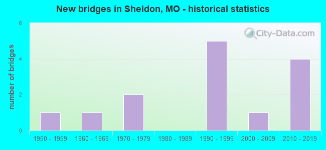
- New bridges - historical statistics
- 11950-1959
- 11960-1969
- 21970-1979
- 51990-1999
- 12000-2009
- 42010-2019


- Bridge Condition - Deck
- 12.5%Very good
- 87.5%Good

- Bridge Condition - Superstructure
- 12.5%Very good
- 75.0%Good
- 12.5%Satisfactory

- Bridge Condition - Substructure
- 12.5%Excellent
- 12.5%Very good
- 12.5%Good
- 62.5%Satisfactory

- Bridge Condition - Channel
- 44.4%Good
- 44.4%Satisfactory
- 11.1%Poor

- Bridge Condition - Culverts
- 50.0%Satisfactory
- 50.0%Fair
Find on map >> Show street view
Structure Number: 1458, Location: S 3 T 33 N R 31 W (Lat: 37.647753, Lng: -94.326514), Route carried "on" structure: County highway 70, Year Built: 2000, Status: Open, Structure Length: 0.91m (2.99ft), Average Daily Traffic: 100 (year 2021), Truck Traffic: 10%, Average Future Daily Traffic: 140 (year 2041), Design Load: HS 20, Features Intersected: TRIB LIT DRYWOOD C, Facility Carried by Structure: NW 100TH RD
Minimum Vertical Clearance: 30+ m (98+ ft), Kilometerpoint: 4.828, Lanes on structure: 2, Owner: County Highway Agency, Approaching Roadway Width: 6.7m (22.0ft), Material/Design: Steel, Design/Construction: Stringer/Multi-beam, Number Of Spans In Main Unit: 1, Length of Maximum Span: 8.2m (26.9ft), Curb-To-Curb Width: 7.3m (24.0ft), Out-to-Out Width: 7.4m (24.3ft)
Condition: Deck: Very good, Superstructure: Very good, Substructure: Good, Channel: Satisfactory, Operating Rating: 41.4 metric tons, Method Used To Determine Operating Rating: Load Factor (LF), Inventory Rating: 24.3 metric tons, Method Used To Determine Inventory Rating: Load Factor (LF), Structural Evaluation: Equal to present minimum criteria, Deck Geometry: Equal to present minimum criteria, Waterway Adequacy: Better than present minimum criteria, Approach Roadway Alignment: Equal to present desirable criteria, Designated Inspection Frequency: Every 24 months, Inspection Date: March 2021, Deck Structure Type: Concrete Cast-file-Place, Wearing Surface/Protective System: Wearing Surface: Monolithic Concrete
Find on map >> Show street view
Structure Number: 24947, Location: S 15 T 34 N R 31 W (Lat: 37.692708, Lng: -94.327178), Route carried "on" structure: County highway 584, Year Built: 1998, Status: Open, Structure Length: 0.94m (3.08ft), Average Daily Traffic: 45 (year 2022), Truck Traffic: 10%, Average Future Daily Traffic: 59 (year 2042), Features Intersected: TRIB PLEASANT CR, Facility Carried by Structure: COUNTY RD 1725
Minimum Vertical Clearance: 30+ m (98+ ft), Kilometerpoint: 3.058, Lanes on structure: 2, Owner: County Highway Agency, Approaching Roadway Width: 5.8m (19.0ft), Material/Design: Steel, Design/Construction: Stringer/Multi-beam, Number Of Spans In Main Unit: 1, Length of Maximum Span: 8.5m (27.9ft), Curb-To-Curb Width: 6.1m (20.0ft), Out-to-Out Width: 6.2m (20.3ft)
Condition: Deck: Good, Superstructure: Good, Substructure: Satisfactory, Channel: Satisfactory, Operating Rating: 36.9 metric tons, Method Used To Determine Operating Rating: Load Factor (LF), Inventory Rating: 21.6 metric tons, Method Used To Determine Inventory Rating: Load Factor (LF), Structural Evaluation: Equal to present minimum criteria, Deck Geometry: Somewhat better than minimum adequacy, Waterway Adequacy: Better than present minimum criteria, Approach Roadway Alignment: Equal to present desirable criteria, Designated Inspection Frequency: Every 24 months, Inspection Date: Febuary 2022, Deck Structure Type: Concrete Cast-file-Place, Wearing Surface/Protective System: Wearing Surface: Monolithic Concrete
Find on map >> Show street view
Structure Number: 2523, Location: S 19 T 34 N R 30 W (Lat: 37.675619, Lng: -94.261942), Route carried "on" structure: County highway 699, Year Built: 1998, Status: Open, Structure Length: 1.83m (6.00ft), Average Daily Traffic: 25 (year 2022), Truck Traffic: 10%, Average Future Daily Traffic: 33 (year 2042), Design Load: HS 20, Features Intersected: TRIB OF CLEAR CR, Facility Carried by Structure: COUNTY RD YATER
Minimum Vertical Clearance: 30+ m (98+ ft), Kilometerpoint: 0.966, Lanes on structure: 2, Owner: County Highway Agency, Approaching Roadway Width: 5.5m (18.0ft), Material/Design: Steel, Design/Construction: Stringer/Multi-beam, Number Of Spans In Main Unit: 1, Length of Maximum Span: 17.4m (57.1ft), Curb-To-Curb Width: 6.1m (20.0ft), Out-to-Out Width: 6.2m (20.3ft)
Condition: Deck: Good, Superstructure: Good, Substructure: Satisfactory, Channel: Satisfactory, Operating Rating: 42.3 metric tons, Method Used To Determine Operating Rating: Load Factor (LF), Inventory Rating: 25.2 metric tons, Method Used To Determine Inventory Rating: Load Factor (LF), Structural Evaluation: Equal to present minimum criteria, Deck Geometry: Somewhat better than minimum adequacy, Waterway Adequacy: Better than present minimum criteria, Approach Roadway Alignment: Equal to present desirable criteria, Designated Inspection Frequency: Every 24 months, Inspection Date: Febuary 2022, Deck Structure Type: Concrete Cast-file-Place, Wearing Surface/Protective System: Wearing Surface: Monolithic Concrete
Find on map >> Show street view
Structure Number: 25253, Location: S 36 T 34 N R 31 W (Lat: 37.646956, Lng: -94.284353), Route carried "on" structure: County highway 719, Year Built: 1996, Status: Open, Structure Length: 1.52m (4.99ft), Average Daily Traffic: 50 (year 2022), Truck Traffic: 10%, Average Future Daily Traffic: 65 (year 2042), Design Load: HS 20, Features Intersected: TRIB CLEAR CR, Facility Carried by Structure: COUNTY RD ZODIAC
Minimum Vertical Clearance: 30+ m (98+ ft), Kilometerpoint: 1.448, Lanes on structure: 2, Owner: County Highway Agency, Approaching Roadway Width: 6.1m (20.0ft), Material/Design: Steel, Design/Construction: Stringer/Multi-beam, Number Of Spans In Main Unit: 1, Length of Maximum Span: 14.3m (46.9ft), Curb-To-Curb Width: 6.0m (19.7ft), Out-to-Out Width: 6.2m (20.3ft)
Condition: Deck: Good, Superstructure: Satisfactory, Substructure: Satisfactory, Channel: Good, Operating Rating: 58.5 metric tons, Method Used To Determine Operating Rating: Load Factor (LF), Inventory Rating: 35.1 metric tons, Method Used To Determine Inventory Rating: Load Factor (LF), Structural Evaluation: Equal to present minimum criteria, Deck Geometry: Meets minimum limits, Waterway Adequacy: Better than present minimum criteria, Approach Roadway Alignment: Equal to present desirable criteria, Designated Inspection Frequency: Every 24 months, Inspection Date: Febuary 2022, Deck Structure Type: Concrete Cast-file-Place
Find on map >> Show street view
Structure Number: 28235, Location: S 19 T 34 N R 30 W (Lat: 37.675881, Lng: -94.271725), Route carried "on" structure: County highway 699, Year Built: 1998, Status: Open, Structure Length: 0.76m (2.49ft), Average Daily Traffic: 25 (year 2022), Truck Traffic: 10%, Average Future Daily Traffic: 33 (year 2042), Design Load: HS 20, Features Intersected: TRIB OF CLEAR CR, Facility Carried by Structure: COUNTY RD YATER
Minimum Vertical Clearance: 30+ m (98+ ft), Kilometerpoint: 0.161, Lanes on structure: 2, Owner: County Highway Agency, Approaching Roadway Width: 5.5m (18.0ft), Skew: 1 degrees, Material/Design: Steel, Design/Construction: Stringer/Multi-beam, Number Of Spans In Main Unit: 1, Length of Maximum Span: 6.7m (22.0ft), Curb-To-Curb Width: 6.1m (20.0ft), Out-to-Out Width: 6.2m (20.3ft)
Condition: Deck: Good, Superstructure: Good, Substructure: Satisfactory, Channel: Good, Operating Rating: 32.4 metric tons, Method Used To Determine Operating Rating: Load Factor (LF), Inventory Rating: 18.9 metric tons, Method Used To Determine Inventory Rating: Load Factor (LF), Structural Evaluation: Somewhat better than minimum adequacy, Deck Geometry: Somewhat better than minimum adequacy, Waterway Adequacy: Better than present minimum criteria, Approach Roadway Alignment: Equal to present desirable criteria, Designated Inspection Frequency: Every 24 months, Inspection Date: Febuary 2022, Deck Structure Type: Concrete Cast-file-Place, Wearing Surface/Protective System: Wearing Surface: Monolithic Concrete
Find on map >> Show street view
Structure Number: 28236, Location: S 19 T 34 N R 30 W (Lat: 37.675917, Lng: -94.270094), Route carried "on" structure: County highway 699, Year Built: 1997, Status: Open, Structure Length: 0.76m (2.49ft), Average Daily Traffic: 25 (year 2022), Truck Traffic: 10%, Average Future Daily Traffic: 33 (year 2042), Design Load: HS 20, Features Intersected: TRIB OF CLEAR CR, Facility Carried by Structure: COUNTY RD YATER
Minimum Vertical Clearance: 30+ m (98+ ft), Kilometerpoint: 0.322, Lanes on structure: 2, Owner: County Highway Agency, Approaching Roadway Width: 5.5m (18.0ft), Material/Design: Steel, Design/Construction: Stringer/Multi-beam, Number Of Spans In Main Unit: 1, Length of Maximum Span: 6.7m (22.0ft), Curb-To-Curb Width: 6.1m (20.0ft), Out-to-Out Width: 6.2m (20.3ft)
Condition: Deck: Good, Superstructure: Good, Substructure: Satisfactory, Channel: Good, Operating Rating: 28.8 metric tons, Method Used To Determine Operating Rating: Load Factor (LF), Inventory Rating: 17.1 metric tons, Method Used To Determine Inventory Rating: Load Factor (LF), Structural Evaluation: Somewhat better than minimum adequacy, Deck Geometry: Somewhat better than minimum adequacy, Waterway Adequacy: Better than present minimum criteria, Approach Roadway Alignment: Equal to present desirable criteria, Designated Inspection Frequency: Every 24 months, Inspection Date: Febuary 2022, Deck Structure Type: Concrete Cast-file-Place, Wearing Surface/Protective System: Wearing Surface: Monolithic Concrete
Find on map >> Show street view
Structure Number: 33111, Location: S 28 T 34 N R 31 W (Lat: 37.669928, Lng: -94.344414), Route carried "on" structure: State highway N, Year Built: 2010, Status: Open, Structure Length: 3.26m (10.70ft), Average Daily Traffic: 436 (year 2021), Truck Traffic: 15%, Average Future Daily Traffic: 610 (year 2041), Design Load: HS 20, Features Intersected: LIT DRYWOOD CR
Minimum Vertical Clearance: 30+ m (98+ ft), Kilometerpoint: 23.957, Lanes on structure: 2, Owner: State Highway Agency, Approaching Roadway Width: 6.1m (20.0ft), Material/Design: Prestressed concrete, Design/Construction: Box Beam or Girders - Multiple, Number Of Spans In Main Unit: 1, Length of Maximum Span: 32.0m (105.0ft), Curb-To-Curb Width: 7.3m (24.0ft), Out-to-Out Width: 7.9m (25.9ft)
Condition: Deck: Good, Superstructure: Good, Substructure: Very good, Channel: Good, Operating Rating: 68.4 metric tons, Method Used To Determine Operating Rating: Load Factor (LF), Inventory Rating: 34.2 metric tons, Method Used To Determine Inventory Rating: Load Factor (LF), Structural Evaluation: Better than present minimum criteria, Deck Geometry: Meets minimum limits, Waterway Adequacy: Superior to present desirable criteria, Approach Roadway Alignment: Equal to present desirable criteria, Designated Inspection Frequency: Every 24 months, Inspection Date: June 2021, Deck Structure Type: Concrete Precast Panels, Wearing Surface/Protective System: Wearing Surface: Bituminous
Find on map >> Show street view
Structure Number: 33279, Location: S 15 T 34 N R 31 W (Lat: 37.705847, Lng: -94.308303), Route carried "on" structure: State highway BB, Year Built: 2010, Status: Open, Structure Length: 5.66m (18.57ft), Average Daily Traffic: 299 (year 2021), Truck Traffic: 7%, Average Future Daily Traffic: 419 (year 2041), Features Intersected: IS 49
Minimum Vertical Clearance: 5.19m (17.03ft), Kilometerpoint: 21.678, Lanes on structure: 2, Lanes under structure: 4, Owner: State Highway Agency, Approaching Roadway Width: 8.5m (27.9ft), Material/Design: Prestressed concrete, Design/Construction: Stringer/Multi-beam, Number Of Spans In Main Unit: 2, Length of Maximum Span: 28.0m (91.9ft), Curb-To-Curb Width: 8.5m (27.9ft), Out-to-Out Width: 9.3m (30.5ft)
Condition: Deck: Good, Superstructure: Good, Substructure: Excellent, Operating Rating: 53.1 metric tons, Method Used To Determine Operating Rating: Load Factor (LF), Inventory Rating: 31.5 metric tons, Method Used To Determine Inventory Rating: Load Factor (LF), Structural Evaluation: Better than present minimum criteria, Deck Geometry: Equal to present minimum criteria, Underclear: Equal to present minimum criteria, Approach Roadway Alignment: Equal to present desirable criteria, Designated Inspection Frequency: Every 24 months, Inspection Date: June 2021, Deck Structure Type: Concrete Cast-file-Place, Wearing Surface/Protective System: Wearing Surface: Monolithic Concrete, Deck Protection: Epoxy Coated Reinforcing
Find on map >> Show street view
Structure Number: 8247, Location: S 28 T 34 N R 31 W (Lat: 37.668539, Lng: -94.330197), Route carried "on" structure: State highway N, Year Built: 1962, Status: Open, Structure Length: 0.67m (2.20ft), Average Daily Traffic: 436 (year 2021), Truck Traffic: 15%, Average Future Daily Traffic: 610 (year 2041), Design Load: H 15, Features Intersected: LIT DRYWOOD CR
Minimum Vertical Clearance: 30+ m (98+ ft), Kilometerpoint: 25.262, Lanes on structure: 2, Owner: State Highway Agency, Approaching Roadway Width: 7.3m (24.0ft), Skew: 2 degrees, Material/Design: Concrete continuous, Design/Construction: Culvert, Number Of Spans In Main Unit: 2, Length of Maximum Span: 3.0m (9.8ft), Curb-To-Curb Width: 7.9m (25.9ft), Out-to-Out Width: 8.5m (27.9ft)
Condition: Channel: Satisfactory, Culverts: Satisfactory, Operating Rating: 65.7 metric tons, Method Used To Determine Operating Rating: Load Factor (LF), Inventory Rating: 39.6 metric tons, Method Used To Determine Inventory Rating: Load Factor (LF), Structural Evaluation: Equal to present minimum criteria, Deck Geometry: Somewhat better than minimum adequacy, Waterway Adequacy: Equal to present desirable criteria, Approach Roadway Alignment: Equal to present minimum criteria, Designated Inspection Frequency: Every 24 months, Inspection Date: March 2022
Find on map >> Show street view
Structure Number: 9048, Location: S 29 T 34 N R 30 W (Lat: 37.660650, Lng: -94.247725), Route carried "on" structure: State highway B, Year Built: 1953, Status: Open, Structure Length: 0.77m (2.53ft), Average Daily Traffic: 1,247 (year 2021), Truck Traffic: 12%, Average Future Daily Traffic: 1,746 (year 2041), Design Load: H 10, Features Intersected: COAL CR
Minimum Vertical Clearance: 30+ m (98+ ft), Kilometerpoint: 5.488, Lanes on structure: 2, Owner: State Highway Agency, Approaching Roadway Width: 5.8m (19.0ft), Skew: 1 degrees, Material/Design: Concrete continuous, Design/Construction: Culvert, Number Of Spans In Main Unit: 2, Length of Maximum Span: 3.7m (12.1ft), Curb-To-Curb Width: 7.3m (24.0ft), Out-to-Out Width: 7.9m (25.9ft)
Condition: Channel: Poor, Culverts: Fair, Operating Rating: 43.2 metric tons, Method Used To Determine Operating Rating: Load Factor (LF), Inventory Rating: 26.1 metric tons, Method Used To Determine Inventory Rating: Load Factor (LF), Structural Evaluation: Somewhat better than minimum adequacy, Deck Geometry: Meets minimum limits, Waterway Adequacy: Equal to present minimum criteria, Approach Roadway Alignment: Equal to present minimum criteria, Designated Inspection Frequency: Every 24 months, Inspection Date: March 2022
Find on map >> Show street view
Structure Number: 2433, Location: S 26 T 34 N R 31 W (Lat: 37.662044, Lng: -94.309086), Route carried "under" structure: Interstate 49, Year Built: 1975, Structure Length: 0. m, Average Daily Traffic: 5,830 (year 2021), Truck Traffic: 41%, Features Intersected: IS 49, Facility Carried by Structure: RT B E
Minimum Vertical Clearance: 5.00m (16.40ft), Kilometerpoint: 152.793, Lanes on structure: 2, Lanes under structure: 2, Material/Design: Steel continuous, Design/Construction: Stringer/Multi-beam, Length of Maximum Span: 26.5m (86.9ft)
Find on map >> Show street view
Structure Number: 2433, Location: S 26 T 34 N R 31 W (Lat: 37.662044, Lng: -94.309086), Route carried "under" structure: Interstate 49, Year Built: 1975, Structure Length: 0. m, Average Daily Traffic: 5,644 (year 2021), Truck Traffic: 46%, Features Intersected: IS 49, Facility Carried by Structure: RT B E
Minimum Vertical Clearance: 4.98m (16.34ft), Kilometerpoint: 143.299, Lanes on structure: 2, Lanes under structure: 2, Material/Design: Steel continuous, Design/Construction: Stringer/Multi-beam, Length of Maximum Span: 26.5m (86.9ft)
Find on map >> Show street view
Structure Number: 33279, Location: S 15 T 34 N R 31 W (Lat: 37.705847, Lng: -94.308303), Route carried "under" structure: Interstate 49, Year Built: 2010, Structure Length: 0. m, Average Daily Traffic: 5,464 (year 2021), Truck Traffic: 41%, Features Intersected: IS 49, Facility Carried by Structure: RT BB S
Minimum Vertical Clearance: 5.08m (16.67ft), Kilometerpoint: 148.165, Lanes on structure: 2, Lanes under structure: 2, Material/Design: Prestressed concrete, Design/Construction: Stringer/Multi-beam, Length of Maximum Span: 28.0m (91.9ft)
Find on map >> Show street view
Structure Number: 33279, Location: S 15 T 34 N R 31 W (Lat: 37.705847, Lng: -94.308303), Route carried "under" structure: Interstate 49, Year Built: 2010, Structure Length: 0. m, Average Daily Traffic: 6,147 (year 2021), Truck Traffic: 41%, Features Intersected: IS 49, Facility Carried by Structure: RT BB S
Minimum Vertical Clearance: 5.18m (16.99ft), Kilometerpoint: 147.928, Lanes on structure: 2, Lanes under structure: 2, Material/Design: Prestressed concrete, Design/Construction: Stringer/Multi-beam, Length of Maximum Span: 28.0m (91.9ft)