Bridge Statistics for Shenandoah Farms, Virginia (VA)
Condition, Traffic, Stress, Structural Evaluation, Project Costs
- National Bridge Inventory (NBI) Statistics
- 26Number of bridges
- 187ft / 57.3mTotal length
- $121,000Total costs
- 100,167Total average daily traffic
- 10,783Total average daily truck traffic
- National Bridge Inventory (NBI) Registered Bridges for Shenandoah Farms
- No street view available for this location
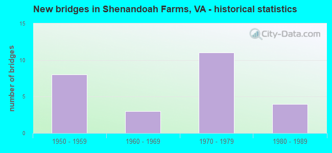
- New bridges - historical statistics
- 81950-1959
- 31960-1969
- 111970-1979
- 41980-1989

- Reconstructed bridges - Historical Statistics
- 11970-1979
- 11980-1989
- 21990-1999
- 22000-2009


- Bridge Condition - Deck
- 45.5%Good
- 45.5%Satisfactory
- 9.1%Fair

- Bridge Condition - Superstructure
- 36.4%Good
- 27.3%Satisfactory
- 36.4%Fair

- Bridge Condition - Substructure
- 9.1%Very good
- 18.2%Good
- 63.6%Satisfactory
- 9.1%Fair

- Bridge Condition - Channel
- 23.8%Very good
- 33.3%Good
- 33.3%Satisfactory
- 9.5%Fair

- Bridge Condition - Culverts
- 81.8%Satisfactory
- 18.2%Fair
Find on map >> Show street view
Structure Number: 5383, Location: 0.60 TO 600 - 0.60 TO 606 (Lat: 39.024297, Lng: -77.975342), Route carried "on" structure: US 17, Year Built: 1975, Status: Open, Structure Length: 0.73m (2.40ft), Average Daily Traffic: 13,078 (year 2020), Truck Traffic: 6%, Average Future Daily Traffic: 14,386 (year 2040), Design Load: HS 20+Mod, Features Intersected: TRIB SHENANDOAH RIVER, Facility Carried by Structure: JOHN MOSBY HWY
Minimum Vertical Clearance: 30+ m (98+ ft), Kilometerpoint: 51.868, Lanes on structure: 4, Base Highway Network: Yes, Owner: State Highway Agency, Approaching Roadway Width: 7.3m (24.0ft), Skew: 3 degrees, Material/Design: Concrete, Design/Construction: Culvert, Number Of Spans In Main Unit: 2, Length of Maximum Span: 3.0m (9.8ft)
Condition: Channel: Very good, Culverts: Satisfactory, Operating Rating: 89.8 metric tons, Method Used To Determine Operating Rating: Load Factor (LF), Inventory Rating: 63.5 metric tons, Method Used To Determine Inventory Rating: Load Factor (LF), Structural Evaluation: Equal to present minimum criteria, Waterway Adequacy: Equal to present minimum criteria, Approach Roadway Alignment: Equal to present desirable criteria, Designated Inspection Frequency: Every 24 months, Inspection Date: March 2021
Find on map >> Show street view
Structure Number: 5386, Location: 0.03 TO 602 - 0.40 TO 638 (Lat: 39.034781, Lng: -77.991519), Route carried "on" structure: US 17, Year Built: 1975, Status: Open, Structure Length: 0.73m (2.40ft), Average Daily Traffic: 13,078 (year 2020), Truck Traffic: 6%, Average Future Daily Traffic: 14,386 (year 2040), Design Load: HS 20+Mod, Features Intersected: TRIB SHEN RIVER, Facility Carried by Structure: JOHN MARSHALL HWY
Minimum Vertical Clearance: 30+ m (98+ ft), Kilometerpoint: 50.066, Lanes on structure: 4, Base Highway Network: Yes, Owner: State Highway Agency, Approaching Roadway Width: 14.6m (47.9ft), Skew: 3 degrees, Material/Design: Concrete, Design/Construction: Culvert, Number Of Spans In Main Unit: 2, Length of Maximum Span: 3.0m (9.8ft)
Condition: Channel: Good, Culverts: Satisfactory, Operating Rating: 89.8 metric tons, Method Used To Determine Operating Rating: Load Factor (LF), Inventory Rating: 88.9 metric tons, Method Used To Determine Inventory Rating: Load Factor (LF), Structural Evaluation: Equal to present minimum criteria, Waterway Adequacy: Equal to present minimum criteria, Approach Roadway Alignment: Better than present minimum criteria, Designated Inspection Frequency: Every 24 months, Inspection Date: June 2020
Find on map >> Show street view
Structure Number: 5389, Location: 0.30 TO 638 - 0.20 TO 622 (Lat: 39.042389, Lng: -78.000297), Route carried "on" structure: US 17, Year Built: 1975, Status: Open, Structure Length: 33.31m (109.28ft), Average Daily Traffic: 6,539 (year 2020), Truck Traffic: 6%, Average Future Daily Traffic: 8,455 (year 2040), Design Load: HS 20+Mod, Features Intersected: SHENANDOAH RIVER & RT622, Facility Carried by Structure: JOHN MOSBY HWY-NBL
Minimum Vertical Clearance: 30+ m (98+ ft), Kilometerpoint: 48.967, Lanes on structure: 2, Lanes under structure: 2, Base Highway Network: Yes, Owner: State Highway Agency, Approaching Roadway Width: 7.3m (24.0ft), Material/Design: Steel continuous, Design/Construction: Stringer/Multi-beam, Number Of Spans In Main Unit: 4, Number Of Approach Spans: 9, Length of Maximum Span: 52.4m (171.9ft), Curb-To-Curb Width: 11.0m (36.1ft), Out-to-Out Width: 12.2m (40.0ft)
Condition: Deck: Good, Superstructure: Fair, Substructure: Satisfactory, Channel: Very good, Operating Rating: 48.1 metric tons, Method Used To Determine Operating Rating: Load and Resistance Factor (LRFR), Inventory Rating: 37.2 metric tons, Method Used To Determine Inventory Rating: Load and Resistance Factor (LRFR), Structural Evaluation: Somewhat better than minimum adequacy, Deck Geometry: Equal to present minimum criteria, Underclear: Somewhat better than minimum adequacy, Waterway Adequacy: Equal to present desirable criteria, Approach Roadway Alignment: Better than present minimum criteria, Designated Inspection Frequency: Every 24 months, Underwater Inspection Frequency: Every 60 months, Inspection Date: August 2021, Underwater Inspection Date: July 2019, Deck Structure Type: Concrete Cast-file-Place, Wearing Surface/Protective System: Wearing Surface: Epoxy Overlay
Find on map >> Show street view
Structure Number: 5439, Location: 1.20 TO 626 - 0.00 TO 622 (Lat: 39.035856, Lng: -78.053128), Route carried "on" structure: County highway 624, Year Built: 1952, Status: Posted for load, Structure Length: 1.34m (4.40ft), Average Daily Traffic: 335 (year 2020), Truck Traffic: 2%, Average Future Daily Traffic: 469 (year 2040), Design Load: H 20, Features Intersected: LONG BRANCH, Facility Carried by Structure: RED GATE RD
Minimum Vertical Clearance: 30+ m (98+ ft), Kilometerpoint: 3.784, Lanes on structure: 2, Owner: State Highway Agency, Approaching Roadway Width: 4.9m (16.1ft), Material/Design: Steel, Design/Construction: Stringer/Multi-beam, Number Of Spans In Main Unit: 1, Length of Maximum Span: 13.4m (44.0ft), Curb or Sidewalk Widths: Left: 0.3m (1.0ft), Right: 0.3m (1.0ft), Curb-To-Curb Width: 6.7m (22.0ft), Out-to-Out Width: 7.2m (23.6ft)
Condition: Deck: Fair, Superstructure: Good, Substructure: Satisfactory, Channel: Very good, Operating Rating: 27.2 metric tons, Method Used To Determine Operating Rating: Load and Resistance Factor (LRFR), Inventory Rating: 20.9 metric tons, Method Used To Determine Inventory Rating: Load and Resistance Factor (LRFR), Structural Evaluation: Equal to present minimum criteria, Deck Geometry: Meets minimum limits, Waterway Adequacy: Equal to present minimum criteria, Approach Roadway Alignment: Better than present minimum criteria, Designated Inspection Frequency: Every 24 months, Inspection Date: December 2021, Deck Structure Type: Concrete Cast-file-Place, Wearing Surface/Protective System: Wearing Surface: Epoxy Overlay
Find on map >> Show street view
Structure Number: 5447, Location: 0.00 TO 622 - 0.06 TO 644 (Lat: 39.024783, Lng: -78.104772), Route carried "on" structure: County highway 658, Year Built: 1968, Status: Open, Structure Length: 0.61m (2.00ft), Average Daily Traffic: 321 (year 2020), Truck Traffic: 1%, Average Future Daily Traffic: 353 (year 2040), Design Load: HS 20, Features Intersected: BORDENS MARSH RUN, Facility Carried by Structure: SUGAR HILL RD
Minimum Vertical Clearance: 30+ m (98+ ft), Kilometerpoint: 2.634, Lanes on structure: 2, Owner: State Highway Agency, Approaching Roadway Width: 6.7m (22.0ft), Material/Design: Concrete, Design/Construction: Culvert, Number Of Spans In Main Unit: 3, Length of Maximum Span: 1.8m (5.9ft)
Condition: Channel: Very good, Culverts: Satisfactory, Operating Rating: 89.8 metric tons, Method Used To Determine Operating Rating: Field evaluation and documented engineering judgment, Inventory Rating: 88.9 metric tons, Method Used To Determine Inventory Rating: Field evaluation and documented engineering judgment, Structural Evaluation: Equal to present minimum criteria, Waterway Adequacy: Equal to present minimum criteria, Approach Roadway Alignment: Equal to present minimum criteria, Designated Inspection Frequency: Every 24 months, Inspection Date: December 2021
Find on map >> Show street view
Structure Number: 7106, Location: .08 Fr 688 & .32 To End (Lat: 38.908600, Lng: -77.996522), Route carried "on" structure: ServiceCounty highway F284, Year Built: 1979, Status: Open, Structure Length: 0.76m (2.49ft), Average Daily Traffic: 113 (year 2015), Average Future Daily Traffic: 127 (year 2040), Design Load: HS 20, Features Intersected: Branch Goose Creek, Facility Carried by Structure: Marshall School Ln
Minimum Vertical Clearance: 30+ m (98+ ft), Kilometerpoint: 4.312, Lanes on structure: 2, Owner: State Highway Agency, Approaching Roadway Width: 4.6m (15.1ft), Material/Design: Concrete, Design/Construction: Culvert, Number Of Spans In Main Unit: 3, Length of Maximum Span: 2.4m (7.9ft)
Condition: Channel: Good, Culverts: Satisfactory, Operating Rating: 89.8 metric tons, Method Used To Determine Operating Rating: Load Factor (LF), Inventory Rating: 64.4 metric tons, Method Used To Determine Inventory Rating: Load Factor (LF), Structural Evaluation: Equal to present minimum criteria, Waterway Adequacy: Equal to present desirable criteria, Approach Roadway Alignment: Equal to present desirable criteria, Designated Inspection Frequency: Every 24 months, Inspection Date: September 2021
Find on map >> Show street view
Structure Number: 7137, Location: .82 Fr 50 & .50 To 710 (Lat: 38.991469, Lng: -77.948761), Route carried "on" structure: US 17, Year Built: 1957, Status: Open, Structure Length: 0.82m (2.69ft), Average Daily Traffic: 7,140 (year 2020), Truck Traffic: 6%, Average Future Daily Traffic: 7,854 (year 2040), Design Load: HS 20, Features Intersected: Gap Run, Facility Carried by Structure: Winchester Road
Minimum Vertical Clearance: 30+ m (98+ ft), Kilometerpoint: 385.204, Lanes on structure: 2, Base Highway Network: Yes, Owner: State Highway Agency, Approaching Roadway Width: 7.3m (24.0ft), Skew: 4 degrees, Material/Design: Concrete, Design/Construction: Culvert, Number Of Spans In Main Unit: 3, Length of Maximum Span: 2.4m (7.9ft)
Condition: Channel: Fair, Culverts: Satisfactory, Operating Rating: 60.8 metric tons, Method Used To Determine Operating Rating: Load Factor (LF), Inventory Rating: 36.3 metric tons, Method Used To Determine Inventory Rating: Load Factor (LF), Structural Evaluation: Equal to present minimum criteria, Waterway Adequacy: Somewhat better than minimum adequacy, Approach Roadway Alignment: Equal to present desirable criteria, Designated Inspection Frequency: Every 24 months, Inspection Date: November 2021
Find on map >> Show street view
Structure Number: 7206, Location: 4.48 Warrn CL; 3.10 To 55 (Lat: 38.907386, Lng: -77.998136), Route carried "on" structure: Interstate 66, Year Built: 1978, Status: Open, Structure Length: 4.59m (15.06ft), Average Daily Traffic: 17,037 (year 2020), Truck Traffic: 15%, Average Future Daily Traffic: 23,852 (year 2040), Design Load: HS 20+Mod, Features Intersected: Rte 688
Minimum Vertical Clearance: 30+ m (98+ ft), Kilometerpoint: 30.571, Lanes on structure: 2, Lanes under structure: 4, Base Highway Network: Yes, Owner: State Highway Agency, Approaching Roadway Width: 12.2m (40.0ft), Material/Design: Prestressed concrete, Design/Construction: Stringer/Multi-beam, Number Of Spans In Main Unit: 3, Length of Maximum Span: 21.0m (68.9ft), Curb-To-Curb Width: 12.4m (40.7ft), Out-to-Out Width: 13.4m (44.0ft)
Condition: Deck: Satisfactory, Superstructure: Fair, Substructure: Fair, Operating Rating: 84.4 metric tons, Method Used To Determine Operating Rating: Load and Resistance Factor (LRFR), Inventory Rating: 48.1 metric tons, Method Used To Determine Inventory Rating: Load and Resistance Factor (LRFR), Structural Evaluation: Somewhat better than minimum adequacy, Deck Geometry: Better than present minimum criteria, Underclear: Meets minimum limits, Approach Roadway Alignment: Equal to present desirable criteria, Designated Inspection Frequency: Every 24 months, Inspection Date: October 2020, Deck Structure Type: Concrete Cast-file-Place, Wearing Surface/Protective System: Wearing Surface: Epoxy Overlay, Deck Protection: Epoxy Coated Reinforcing
Find on map >> Show street view
Structure Number: 7234, Location: .06 Fr 688 & 1.20 To 724 (Lat: 38.907119, Lng: -77.996861), Route carried "on" structure: Interstate 66, Year Built: 1979, Status: Open, Structure Length: 0.79m (2.59ft), Average Daily Traffic: 36,013 (year 2020), Truck Traffic: 16%, Average Future Daily Traffic: 50,418 (year 2040), Design Load: HS 20, Features Intersected: Branch Goose Creek
Minimum Vertical Clearance: 30+ m (98+ ft), Kilometerpoint: 30.507, Lanes on structure: 6, Base Highway Network: Yes, Owner: State Highway Agency, Approaching Roadway Width: 38.1m (125.0ft), Material/Design: Concrete, Design/Construction: Culvert, Number Of Spans In Main Unit: 3, Length of Maximum Span: 2.4m (7.9ft)
Condition: Channel: Good, Culverts: Satisfactory, Operating Rating: 89.8 metric tons, Method Used To Determine Operating Rating: Load Factor (LF), Inventory Rating: 89.8 metric tons, Method Used To Determine Inventory Rating: Load Factor (LF), Structural Evaluation: Equal to present minimum criteria, Waterway Adequacy: Equal to present desirable criteria, Approach Roadway Alignment: Equal to present desirable criteria, Designated Inspection Frequency: Every 24 months, Inspection Date: January 2022
Find on map >> Show street view
Structure Number: 7368, Location: 4.48 Fr 55 & 1.47 To 711 (Lat: 38.957992, Lng: -77.983453), Route carried "on" structure: County highway 688, Year Built: 1959, Year Reconstructed: 1994, Status: Open, Structure Length: 0.64m (2.10ft), Average Daily Traffic: 214 (year 2015), Average Future Daily Traffic: 321 (year 2040), Design Load: HS 20, Features Intersected: Branch Crooked Run, Facility Carried by Structure: Leeds Manor Road
Minimum Vertical Clearance: 30+ m (98+ ft), Kilometerpoint: 40.273, Lanes on structure: 2, Owner: State Highway Agency, Approaching Roadway Width: 5.8m (19.0ft), Skew: 3 degrees, Material/Design: Steel, Design/Construction: Culvert, Number Of Spans In Main Unit: 3, Length of Maximum Span: 1.5m (4.9ft)
Condition: Channel: Satisfactory, Culverts: Satisfactory, Operating Rating: 44.5 metric tons, Method Used To Determine Operating Rating: Field evaluation and documented engineering judgment, Inventory Rating: 32.7 metric tons, Method Used To Determine Inventory Rating: Field evaluation and documented engineering judgment, Structural Evaluation: Equal to present minimum criteria, Waterway Adequacy: Better than present minimum criteria, Approach Roadway Alignment: Better than present minimum criteria, Designated Inspection Frequency: Every 24 months, Inspection Date: January 2021
Find on map >> Show street view
Structure Number: 737, Location: 4.50 Fr 55 & 1.40 To 711 (Lat: 38.959117, Lng: -77.981600), Route carried "on" structure: County highway 688, Year Built: 1959, Year Reconstructed: 1984, Status: Open, Structure Length: 0.76m (2.49ft), Average Daily Traffic: 214 (year 2015), Average Future Daily Traffic: 321 (year 2040), Design Load: HS 20, Features Intersected: Crooked Run, Facility Carried by Structure: Leeds Manor Road
Minimum Vertical Clearance: 30+ m (98+ ft), Kilometerpoint: 40.305, Lanes on structure: 2, Owner: State Highway Agency, Approaching Roadway Width: 5.5m (18.0ft), Material/Design: Concrete, Design/Construction: Slab, Number Of Spans In Main Unit: 1, Length of Maximum Span: 6.7m (22.0ft), Curb-To-Curb Width: 6.3m (20.7ft), Out-to-Out Width: 7.3m (24.0ft)
Condition: Deck: Satisfactory, Superstructure: Satisfactory, Substructure: Satisfactory, Channel: Satisfactory, Operating Rating: 66.2 metric tons, Method Used To Determine Operating Rating: Allowable Stress (AS), Inventory Rating: 40.8 metric tons, Method Used To Determine Inventory Rating: Allowable Stress (AS), Structural Evaluation: Equal to present minimum criteria, Deck Geometry: Meets minimum limits, Waterway Adequacy: Equal to present minimum criteria, Approach Roadway Alignment: Equal to present desirable criteria, Designated Inspection Frequency: Every 24 months, Inspection Date: March 2022, Deck Structure Type: Concrete Precast Panels, Wearing Surface/Protective System: Wearing Surface: Bituminous, Membrane: Epoxy
Find on map >> Show street view
Structure Number: 7371, Location: 5.20 Fr 66 & .60 To 711 (Lat: 38.962606, Lng: -77.972161), Route carried "on" structure: County highway 688, Year Built: 1958, Year Reconstructed: 2003, Status: Open, Structure Length: 0.69m (2.26ft), Average Daily Traffic: 214 (year 2015), Average Future Daily Traffic: 321 (year 2040), Design Load: HS 20, Features Intersected: Crooked Run, Facility Carried by Structure: Leeds Manor Road
Minimum Vertical Clearance: 30+ m (98+ ft), Kilometerpoint: 41.625, Lanes on structure: 2, Owner: State Highway Agency, Approaching Roadway Width: 5.2m (17.1ft), Skew: 2 degrees, Material/Design: Concrete, Design/Construction: Slab, Number Of Spans In Main Unit: 1, Length of Maximum Span: 6.1m (20.0ft), Curb-To-Curb Width: 6.2m (20.3ft), Out-to-Out Width: 6.4m (21.0ft)
Condition: Deck: Good, Superstructure: Good, Substructure: Satisfactory, Channel: Fair, Operating Rating: 71.7 metric tons, Method Used To Determine Operating Rating: Load and Resistance Factor (LRFR), Inventory Rating: 55.3 metric tons, Method Used To Determine Inventory Rating: Load and Resistance Factor (LRFR), Structural Evaluation: Equal to present minimum criteria, Deck Geometry: Meets minimum limits, Waterway Adequacy: Somewhat better than minimum adequacy, Approach Roadway Alignment: Equal to present desirable criteria, Designated Inspection Frequency: Every 24 months, Inspection Date: June 2020, Deck Structure Type: Concrete Precast Panels, Wearing Surface/Protective System: Wearing Surface: Bituminous, Membrane: Epoxy, Deck Protection: Epoxy Coated Reinforcing
Find on map >> Show street view
Structure Number: 7372, Location: 5.90 Fr 55 & .01 To 711 (Lat: 38.969800, Lng: -77.967203), Route carried "on" structure: County highway 688, Year Built: 1979, Status: Open, Structure Length: 0.73m (2.40ft), Average Daily Traffic: 214 (year 2015), Average Future Daily Traffic: 321 (year 2040), Design Load: HS 20, Features Intersected: Crooked Run, Facility Carried by Structure: Leeds Manor Road
Minimum Vertical Clearance: 30+ m (98+ ft), Kilometerpoint: 42.655, Lanes on structure: 2, Owner: State Highway Agency, Approaching Roadway Width: 6.1m (20.0ft), Skew: 3 degrees, Material/Design: Concrete, Design/Construction: Slab, Number Of Spans In Main Unit: 1, Length of Maximum Span: 6.7m (22.0ft), Curb-To-Curb Width: 7.9m (25.9ft), Out-to-Out Width: 9.1m (29.9ft)
Condition: Deck: Satisfactory, Superstructure: Satisfactory, Substructure: Good, Channel: Good, Operating Rating: 89.8 metric tons, Method Used To Determine Operating Rating: Load and Resistance Factor (LRFR), Inventory Rating: 89.8 metric tons, Method Used To Determine Inventory Rating: Load and Resistance Factor (LRFR), Structural Evaluation: Equal to present minimum criteria, Deck Geometry: Somewhat better than minimum adequacy, Waterway Adequacy: Equal to present minimum criteria, Approach Roadway Alignment: Equal to present minimum criteria, Designated Inspection Frequency: Every 24 months, Inspection Date: January 2022, Deck Structure Type: Concrete Precast Panels, Wearing Surface/Protective System: Wearing Surface: Bituminous, Membrane: Epoxy
Find on map >> Show street view
Structure Number: 7376, Location: .68 Fr 55 & 5.27 To 711 (Lat: 38.915217, Lng: -78.000017), Route carried "on" structure: County highway 688, Year Built: 1958, Status: Open, Structure Length: 0.88m (2.89ft), Average Daily Traffic: 214 (year 2015), Average Future Daily Traffic: 321 (year 2040), Design Load: HS 20, Features Intersected: Goose Creek, Facility Carried by Structure: Leeds Manor Road
Minimum Vertical Clearance: 30+ m (98+ ft), Kilometerpoint: 34.159, Lanes on structure: 2, Owner: State Highway Agency, Approaching Roadway Width: 6.1m (20.0ft), Skew: 4 degrees, Material/Design: Concrete, Design/Construction: Culvert, Number Of Spans In Main Unit: 2, Length of Maximum Span: 4.3m (14.1ft)
Condition: Channel: Satisfactory, Culverts: Fair, Operating Rating: 63.5 metric tons, Method Used To Determine Operating Rating: Load Factor (LF), Inventory Rating: 38.1 metric tons, Method Used To Determine Inventory Rating: Load Factor (LF), Structural Evaluation: Somewhat better than minimum adequacy, Waterway Adequacy: Better than present minimum criteria, Approach Roadway Alignment: Better than present minimum criteria, Designated Inspection Frequency: Every 24 months, Inspection Date: May 2020
Find on map >> Show street view
Structure Number: 7379, Location: .01 Fr 757 & .01 To 55 (Lat: 38.905469, Lng: -77.997569), Route carried "on" structure: County highway 688, Year Built: 1966, Year Reconstructed: 2007, Status: Open, Structure Length: 1.31m (4.30ft), Average Daily Traffic: 697 (year 2020), Truck Traffic: 4%, Average Future Daily Traffic: 913 (year 2040), Design Load: HS 20, Features Intersected: Goose Creek, Facility Carried by Structure: Leeds Manor Road
Minimum Vertical Clearance: 30+ m (98+ ft), Kilometerpoint: 32.920, Lanes on structure: 2, Owner: State Highway Agency, Approaching Roadway Width: 6.1m (20.0ft), Material/Design: Prestressed concrete, Design/Construction: Slab, Number Of Spans In Main Unit: 1, Length of Maximum Span: 11.9m (39.0ft), Curb-To-Curb Width: 6.5m (21.3ft), Out-to-Out Width: 6.7m (22.0ft)
Condition: Deck: Good, Superstructure: Good, Substructure: Satisfactory, Channel: Satisfactory, Operating Rating: 77.1 metric tons, Method Used To Determine Operating Rating: Load Factor (LF), Inventory Rating: 45.4 metric tons, Method Used To Determine Inventory Rating: Load Factor (LF), Structural Evaluation: Equal to present minimum criteria, Deck Geometry: High priority of corrective action, Waterway Adequacy: Somewhat better than minimum adequacy, Approach Roadway Alignment: Equal to present minimum criteria, Designated Inspection Frequency: Every 24 months, Inspection Date: March 2021, Deck Structure Type: Other, Wearing Surface/Protective System: Wearing Surface: Bituminous, Membrane: Epoxy, Deck Protection: Epoxy Coated Reinforcing
Find on map >> Show street view
Structure Number: 7419, Location: .20 Fr 55 & 2.30 To 638 (Lat: 38.905489, Lng: -78.030006), Route carried "on" structure: County highway 726, Year Built: 1983, Year Reconstructed: 2009, Status: Open, Structure Length: 0.88m (2.89ft), Average Daily Traffic: 81 (year 2015), Average Future Daily Traffic: 122 (year 2040), Design Load: H 20, Features Intersected: Goose Creek, Facility Carried by Structure: Fiery Run Road
Minimum Vertical Clearance: 30+ m (98+ ft), Kilometerpoint: 10.129, Lanes on structure: 2, Owner: State Highway Agency, Approaching Roadway Width: 6.1m (20.0ft), Material/Design: Concrete, Design/Construction: Slab, Number Of Spans In Main Unit: 1, Length of Maximum Span: 7.9m (25.9ft), Curb-To-Curb Width: 7.2m (23.6ft), Out-to-Out Width: 7.3m (24.0ft)
Condition: Deck: Good, Superstructure: Good, Substructure: Satisfactory, Channel: Good, Operating Rating: 89.8 metric tons, Method Used To Determine Operating Rating: Load Factor (LF), Inventory Rating: 55.3 metric tons, Method Used To Determine Inventory Rating: Load Factor (LF), Structural Evaluation: Equal to present minimum criteria, Deck Geometry: Somewhat better than minimum adequacy, Waterway Adequacy: Somewhat better than minimum adequacy, Approach Roadway Alignment: Better than present minimum criteria, Designated Inspection Frequency: Every 24 months, Inspection Date: November 2021, Deck Structure Type: Concrete Precast Panels, Wearing Surface/Protective System: Wearing Surface: Epoxy Overlay, Deck Protection: Epoxy Coated Reinforcing
Find on map >> Show street view
Structure Number: 7435, Location: .01 Fr 55 & .09 To 760 (Lat: 38.905333, Lng: -77.993186), Route carried "on" structure: County highway 757, Year Built: 1956, Year Reconstructed: 1996, Status: Open, Structure Length: 1.55m (5.09ft), Average Daily Traffic: 97 (year 2015), Average Future Daily Traffic: 109 (year 2040), Design Load: HS 20, Features Intersected: Goose Creek, Facility Carried by Structure: Old Markham Road
Minimum Vertical Clearance: 30+ m (98+ ft), Kilometerpoint: 0.549, Lanes on structure: 2, Owner: State Highway Agency, Approaching Roadway Width: 4.9m (16.1ft), Material/Design: Steel, Design/Construction: Stringer/Multi-beam, Number Of Spans In Main Unit: 2, Length of Maximum Span: 7.9m (25.9ft), Curb-To-Curb Width: 6.7m (22.0ft), Out-to-Out Width: 7.3m (24.0ft)
Condition: Deck: Good, Superstructure: Satisfactory, Substructure: Good, Channel: Good, Operating Rating: 58.1 metric tons, Method Used To Determine Operating Rating: Load Factor (LF), Inventory Rating: 34.5 metric tons, Method Used To Determine Inventory Rating: Load Factor (LF), Structural Evaluation: Equal to present minimum criteria, Deck Geometry: Somewhat better than minimum adequacy, Waterway Adequacy: Somewhat better than minimum adequacy, Approach Roadway Alignment: Somewhat better than minimum adequacy, Designated Inspection Frequency: Every 24 months, Inspection Date: August 2020, Deck Structure Type: Wood or Timber, Wearing Surface/Protective System: Wearing Surface: Bituminous
Find on map >> Show street view
Structure Number: 7459, Location: .10 Fr 55 & .10 To End (Lat: 38.906369, Lng: -78.037525), Route carried "on" structure: County highway 822, Year Built: 1961, Status: Posted for load, Structure Length: 1.28m (4.20ft), Average Daily Traffic: 80 (year 2019), Average Future Daily Traffic: 114 (year 2040), Design Load: HS 20, Features Intersected: Goose Creek, Facility Carried by Structure: Distillery Road
Minimum Vertical Clearance: 30+ m (98+ ft), Kilometerpoint: 0.016, Lanes on structure: 1, Owner: State Highway Agency, Approaching Roadway Width: 3.7m (12.1ft), Material/Design: Steel, Design/Construction: Stringer/Multi-beam, Number Of Spans In Main Unit: 2, Length of Maximum Span: 6.4m (21.0ft), Curb-To-Curb Width: 3.7m (12.1ft), Out-to-Out Width: 4.0m (13.1ft)
Condition: Deck: Satisfactory, Superstructure: Fair, Substructure: Satisfactory, Channel: Satisfactory, Operating Rating: 21.8 metric tons, Method Used To Determine Operating Rating: Load Factor (LF), Inventory Rating: 12.7 metric tons, Method Used To Determine Inventory Rating: Load Factor (LF), Structural Evaluation: Meets minimum limits, Deck Geometry: Meets minimum limits, Waterway Adequacy: Equal to present minimum criteria, Approach Roadway Alignment: Equal to present desirable criteria, Bridge Posting: Required (Relationship of Operating Rating to Maximum Legal Load: > 39.9% below), Length Of Structure Improvement: 1.28m (4.20ft), Designated Inspection Frequency: Every 12 months, Inspection Date: October 2021, Bridge Improvement Cost: $30,000, Roadway Improvement Cost: $10,000, Total Project Cost: $50,000 ( Estimate for 2015), Deck Structure Type: Wood or Timber, Wearing Surface/Protective System: Wearing Surface: Bituminous
Find on map >> Show street view
Structure Number: 18793, Location: 0.43 TO 644 - 0.07 TO 642 (Lat: 39.002528, Lng: -78.097478), Route carried "on" structure: County highway 624, Year Built: 1980, Status: Open, Structure Length: 1.28m (4.20ft), Average Daily Traffic: 378 (year 2020), Truck Traffic: 1%, Average Future Daily Traffic: 416 (year 2040), Design Load: HS 20+Mod, Features Intersected: BORDENS MARSH, Facility Carried by Structure: MILLDALE RD
Minimum Vertical Clearance: 30+ m (98+ ft), Kilometerpoint: 10.206, Lanes on structure: 2, Owner: State Highway Agency, Approaching Roadway Width: 5.5m (18.0ft), Material/Design: Concrete, Design/Construction: Culvert, Number Of Spans In Main Unit: 4, Length of Maximum Span: 3.0m (9.8ft)
Condition: Channel: Satisfactory, Culverts: Satisfactory, Operating Rating: 89.8 metric tons, Method Used To Determine Operating Rating: Field evaluation and documented engineering judgment, Inventory Rating: 88.9 metric tons, Method Used To Determine Inventory Rating: Field evaluation and documented engineering judgment, Structural Evaluation: Equal to present minimum criteria, Waterway Adequacy: Equal to present minimum criteria, Approach Roadway Alignment: Better than present minimum criteria, Designated Inspection Frequency: Every 24 months, Inspection Date: October 2020
Find on map >> Show street view
Structure Number: 18796, Location: 0.00 CLARKE - 0.00 WARREN (Lat: 39.015639, Lng: -78.082778), Route carried "on" structure: County highway 624, Year Built: 1950, Status: Open, Structure Length: 0.82m (2.69ft), Average Daily Traffic: 272 (year 2020), Truck Traffic: 2%, Average Future Daily Traffic: 381 (year 2040), Features Intersected: WOLFE MARSH RUN, Facility Carried by Structure: MILLDALE RD
Minimum Vertical Clearance: 30+ m (98+ ft), Kilometerpoint: 12.180, Lanes on structure: 2, Owner: State Highway Agency, Approaching Roadway Width: 4.3m (14.1ft), Material/Design: Steel, Design/Construction: Culvert, Number Of Spans In Main Unit: 2, Length of Maximum Span: 3.7m (12.1ft)
Condition: Channel: Very good, Culverts: Satisfactory, Operating Rating: 54.4 metric tons, Method Used To Determine Operating Rating: Field evaluation and documented engineering judgment, Inventory Rating: 32.7 metric tons, Method Used To Determine Inventory Rating: Field evaluation and documented engineering judgment, Structural Evaluation: Equal to present minimum criteria, Waterway Adequacy: Equal to present minimum criteria, Approach Roadway Alignment: Better than present minimum criteria, Designated Inspection Frequency: Every 24 months, Inspection Date: March 2021
Find on map >> Show street view
Structure Number: 18809, Location: 2.00 TO 721 - 0.08 TO 685 (Lat: 39.003019, Lng: -78.052422), Route carried "on" structure: County highway 638, Year Built: 1976, Status: Open, Structure Length: 1.89m (6.20ft), Average Daily Traffic: 1,718 (year 2020), Truck Traffic: 2%, Average Future Daily Traffic: 2,131 (year 2040), Features Intersected: VENUS BRANCH, Facility Carried by Structure: HOWELLSVILLE RD
Minimum Vertical Clearance: 30+ m (98+ ft), Kilometerpoint: 23.701, Lanes on structure: 2, Owner: State Highway Agency, Approaching Roadway Width: 6.1m (20.0ft), Skew: 1 degrees, Material/Design: Steel, Design/Construction: Stringer/Multi-beam, Number Of Spans In Main Unit: 2, Length of Maximum Span: 9.4m (30.8ft), Curb or Sidewalk Widths: Left: 0.2m (0.7ft), Right: 0.2m (0.7ft), Curb-To-Curb Width: 7.3m (24.0ft), Out-to-Out Width: 8.0m (26.2ft)
Condition: Deck: Satisfactory, Superstructure: Fair, Substructure: Very good, Channel: Good, Operating Rating: 55.3 metric tons, Method Used To Determine Operating Rating: Load Factor (LF), Inventory Rating: 32.7 metric tons, Method Used To Determine Inventory Rating: Load Factor (LF), Structural Evaluation: Somewhat better than minimum adequacy, Deck Geometry: Meets minimum limits, Waterway Adequacy: Equal to present minimum criteria, Approach Roadway Alignment: Better than present minimum criteria, Length Of Structure Improvement: 1.89m (6.20ft), Designated Inspection Frequency: Every 24 months, Inspection Date: March 2020, Bridge Improvement Cost: $64,000, Roadway Improvement Cost: $6,000, Total Project Cost: $71,000, Deck Structure Type: Wood or Timber, Wearing Surface/Protective System: Wearing Surface: Bituminous
Find on map >> Show street view
Structure Number: 18811, Location: 0.90 TO END - 0.15 TO 624 (Lat: 39.000344, Lng: -78.096339), Route carried "on" structure: County highway 642, Year Built: 1989, Status: Open, Structure Length: 0.88m (2.89ft), Average Daily Traffic: 92 (year 2017), Average Future Daily Traffic: 103 (year 2040), Design Load: HS 20, Features Intersected: BORDENS MARSH RUN, Facility Carried by Structure: MILLDALE HOLLOW RD
Minimum Vertical Clearance: 30+ m (98+ ft), Kilometerpoint: 1.681, Lanes on structure: 2, Owner: State Highway Agency, Approaching Roadway Width: 3.0m (9.8ft), Skew: 4 degrees, Material/Design: Steel, Design/Construction: Culvert, Number Of Spans In Main Unit: 3, Length of Maximum Span: 1.5m (4.9ft)
Condition: Channel: Satisfactory, Culverts: Fair, Operating Rating: 54.4 metric tons, Method Used To Determine Operating Rating: Field evaluation and documented engineering judgment, Inventory Rating: 32.7 metric tons, Method Used To Determine Inventory Rating: Field evaluation and documented engineering judgment, Structural Evaluation: Somewhat better than minimum adequacy, Waterway Adequacy: Equal to present minimum criteria, Approach Roadway Alignment: Somewhat better than minimum adequacy, Designated Inspection Frequency: Every 12 months, Inspection Date: June 2021
Find on map >> Show street view
Structure Number: 5381, Location: 0.30 TO 638 - 0.25 TO 622 (Lat: 39.042292, Lng: -78.000481), Route carried "under" structure: County highway 622, Year Built: 1980, Structure Length: 0. m, Average Daily Traffic: 153 (year 2006), Features Intersected: SHENANDOAH RIVER & RT622, Facility Carried by Structure: JOHN MOSBY HWY-SBL
Minimum Vertical Clearance: 7.49m (24.57ft), Kilometerpoint: 11.263, Lanes on structure: 2, Lanes under structure: 2, Material/Design: Steel continuous, Design/Construction: Stringer/Multi-beam, Length of Maximum Span: 52.4m (171.9ft)
Find on map >> Show street view
Structure Number: 5389, Location: 0.30 TO 638 - 0.20 TO 622 (Lat: 39.042389, Lng: -78.000297), Route carried "under" structure: County highway 622, Year Built: 1975, Structure Length: 0. m, Average Daily Traffic: 153 (year 2006), Features Intersected: SHENANDOAH RIVER & RT622, Facility Carried by Structure: JOHN MOSBY HWY-NBL
Minimum Vertical Clearance: 7.14m (23.43ft), Kilometerpoint: 11.263, Lanes on structure: 2, Lanes under structure: 2, Material/Design: Steel continuous, Design/Construction: Stringer/Multi-beam, Length of Maximum Span: 52.4m (171.9ft)
Find on map >> Show street view
Structure Number: 7204, Location: 4.48 Warrn CL; 3.10 To 55 (Lat: 38.907050, Lng: -77.998131), Route carried "under" structure: Interstate 688, Year Built: 1978, Structure Length: 0. m, Average Daily Traffic: 861 (year 2001), Features Intersected: Rte 688, Facility Carried by Structure: I-66 EBL
Minimum Vertical Clearance: 5.33m (17.49ft), Kilometerpoint: 33.274, Lanes on structure: 2, Lanes under structure: 4, Material/Design: Prestressed concrete, Design/Construction: Stringer/Multi-beam, Length of Maximum Span: 21.0m (68.9ft)
Find on map >> Show street view
Structure Number: 7206, Location: 4.48 Warrn CL; 3.10 To 55 (Lat: 38.907386, Lng: -77.998136), Route carried "under" structure: County highway 688, Year Built: 1978, Structure Length: 0. m, Average Daily Traffic: 861 (year 2001), Features Intersected: Rte 688, Facility Carried by Structure: I-66 WBL
Minimum Vertical Clearance: 5.33m (17.49ft), Kilometerpoint: 33.306, Lanes on structure: 2, Lanes under structure: 4, Material/Design: Prestressed concrete, Design/Construction: Stringer/Multi-beam, Length of Maximum Span: 21.0m (68.9ft)