Bridge Statistics for Sheridan, Colorado (CO)
Condition, Traffic, Stress, Structural Evaluation, Project Costs
- National Bridge Inventory (NBI) Statistics
- 15Number of bridges
- 177ft / 53.9mTotal length
- $5,068,000Total costs
- 375,635Total average daily traffic
- 16,559Total average daily truck traffic
- National Bridge Inventory (NBI) Registered Bridges for Sheridan
- No street view available for this location
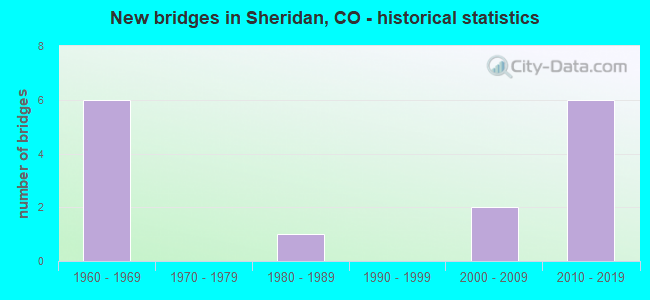
- New bridges - historical statistics
- 61960-1969
- 11980-1989
- 22000-2009
- 62010-2019


- Bridge Condition - Deck
- 10.0%Very good
- 30.0%Good
- 50.0%Satisfactory
- 10.0%Serious

- Bridge Condition - Superstructure
- 10.0%Very good
- 70.0%Good
- 10.0%Satisfactory
- 10.0%Poor

- Bridge Condition - Substructure
- 10.0%Very good
- 60.0%Good
- 10.0%Satisfactory
- 20.0%Fair
Find on map >> Show street view
Structure Number: F-16-BC, Location: 0.1 MI S of JCT US285 (Lat: 39.650492, Lng: -105.025400), Route carried "on" structure: State highway 88A, Year Built: 1966, Status: Open, Structure Length: 2.87m (9.42ft), Average Daily Traffic: 21,000 (year 2020), Truck Traffic: 4%, Average Future Daily Traffic: 21,420 (year 2040), Design Load: HS 20+Mod, Features Intersected: BEAR CREEK, Facility Carried by Structure: SH 88 ML
Minimum Vertical Clearance: 30+ m (98+ ft), Kilometerpoint: 9.971, Lanes on structure: 4, Base Highway Network: Yes, Owner: State Highway Agency, Approaching Roadway Width: 20.7m (67.9ft), Skew: 2 degrees, Material/Design: Concrete, Design/Construction: Tee Beam, Number Of Spans In Main Unit: 3, Length of Maximum Span: 9.4m (30.8ft), Curb or Sidewalk Widths: Left: 1.5m (4.9ft), Right: 1.5m (4.9ft), Curb-To-Curb Width: 20.7m (67.9ft), Out-to-Out Width: 24.5m (80.4ft)
Condition: Deck: Serious, Superstructure: Poor, Substructure: Fair, Channel: Very good, Operating Rating: 50.8 metric tons, Method Used To Determine Operating Rating: Load Factor (LF), Inventory Rating: 30.0 metric tons, Method Used To Determine Inventory Rating: Load Factor (LF), Structural Evaluation: Meets minimum limits, Deck Geometry: Superior to present desirable criteria, Waterway Adequacy: Equal to present desirable criteria, Approach Roadway Alignment: Equal to present desirable criteria, Length Of Structure Improvement: 3.78m (12.40ft), Designated Inspection Frequency: Every 12 months, Inspection Date: June 2021, Bridge Improvement Cost: $1,199,000, Roadway Improvement Cost: $120,000, Total Project Cost: $1,798,000, Deck Structure Type: Concrete Cast-file-Place, Wearing Surface/Protective System: Wearing Surface: Bituminous
Find on map >> Show street view
Structure Number: F-16-ES, Location: IN SHERIDAN (Lat: 39.653653, Lng: -105.005289), Route carried "on" structure: US 285D, Year Built: 1960, Year Reconstructed: 1985, Status: Open, Structure Length: 12.53m (41.11ft), Average Daily Traffic: 67,000 (year 2020), Truck Traffic: 2%, Average Future Daily Traffic: 77,050 (year 2040), Design Load: HS 20+Mod, Features Intersected: SOUTH PLATTE RVR, RDWY, Facility Carried by Structure: US 285 ML
Minimum Vertical Clearance: 30+ m (98+ ft), Kilometerpoint: 156.159, Lanes on structure: 6, Lanes under structure: 4, Base Highway Network: Yes, Owner: State Highway Agency, Approaching Roadway Width: 24.4m (80.1ft), Skew: 20 degrees, Material/Design: Prestressed concrete continuous, Design/Construction: Stringer/Multi-beam, Number Of Spans In Main Unit: 6, Length of Maximum Span: 23.0m (75.5ft), Curb-To-Curb Width: 24.7m (81.0ft), Out-to-Out Width: 25.7m (84.3ft)
Condition: Deck: Satisfactory, Superstructure: Satisfactory, Substructure: Fair, Channel: Very good, Operating Rating: 63.5 metric tons, Method Used To Determine Operating Rating: Load Factor (LF), Inventory Rating: 38.1 metric tons, Method Used To Determine Inventory Rating: Load Factor (LF), Structural Evaluation: Somewhat better than minimum adequacy, Deck Geometry: Meets minimum limits, Underclear: High priority of corrective action, Waterway Adequacy: Equal to present desirable criteria, Approach Roadway Alignment: Equal to present desirable criteria, Length Of Structure Improvement: 12.53m (41.11ft), Designated Inspection Frequency: Every 24 months, Inspection Date: June 2021, Bridge Improvement Cost: $4,000, Total Project Cost: $6,000, Deck Structure Type: Concrete Cast-file-Place, Wearing Surface/Protective System: Wearing Surface: Bituminous, Membrane: Preformed Fabric
Find on map >> Show street view
Structure Number: F-16-FA, Location: IN LITTLETON (Lat: 39.573103, Lng: -105.028786), Route carried "on" structure: US 85B, Year Built: 2013, Status: Open, Structure Length: 3.45m (11.32ft), Average Daily Traffic: 22,000 (year 2020), Truck Traffic: 9%, Average Future Daily Traffic: 27,940 (year 2040), Design Load: HL 93, Features Intersected: DAD CLARK GULCH, Facility Carried by Structure: US 85 ML NBND
Minimum Vertical Clearance: 30+ m (98+ ft), Kilometerpoint: 26.293, Lanes on structure: 2, Base Highway Network: Yes, Owner: State Highway Agency, Approaching Roadway Width: 19.1m (62.7ft), Skew: 2 degrees, Material/Design: Prestressed concrete, Design/Construction: Box Beam or Girders - Single/Spread, Number Of Spans In Main Unit: 1, Length of Maximum Span: 33.5m (109.9ft), Curb-To-Curb Width: 19.1m (62.7ft), Out-to-Out Width: 19.5m (64.0ft)
Condition: Deck: Good, Superstructure: Good, Substructure: Good, Channel: Very good, Operating Rating: 42.1 metric tons, Method Used To Determine Operating Rating: Load and Resistance Factor Rating (LRFR) rating reported by rating factor(RF) method using HL-93 loadings, Inventory Rating: 32.4 metric tons, Method Used To Determine Inventory Rating: Load and Resistance Factor Rating (LRFR) rating reported by rating factor(RF) method using HL-93 loadings, Structural Evaluation: Better than present minimum criteria, Deck Geometry: Superior to present desirable criteria, Waterway Adequacy: Equal to present desirable criteria, Approach Roadway Alignment: Equal to present desirable criteria, Length Of Structure Improvement: 2.47m (8.10ft), Designated Inspection Frequency: Every 24 months, Inspection Date: August 2020, Bridge Improvement Cost: $569,000, Roadway Improvement Cost: $57,000, Total Project Cost: $854,000, Deck Structure Type: Concrete Cast-file-Place, Wearing Surface/Protective System: Wearing Surface: Bituminous, Membrane: Built-up, Deck Protection: Epoxy Coated Reinforcing
Find on map >> Show street view
Structure Number: F-16-FU, Location: SHERIDAN/ENGLEWOOD (Lat: 39.653000, Lng: -105.002042), Route carried "on" structure: US 85B, Year Built: 1961, Year Reconstructed: 1992, Status: Open, Structure Length: 5.77m (18.93ft), Average Daily Traffic: 61,000 (year 2020), Truck Traffic: 8%, Average Future Daily Traffic: 73,810 (year 2040), Design Load: HS 20+Mod, Features Intersected: HAMPDEN AVENUE, Facility Carried by Structure: US 85ML
Minimum Vertical Clearance: 30+ m (98+ ft), Kilometerpoint: 35.600, Lanes on structure: 9, Lanes under structure: 6, Base Highway Network: Yes, Owner: State Highway Agency, Approaching Roadway Width: 44.5m (146.0ft), Skew: 21 degrees, Material/Design: Steel, Design/Construction: Stringer/Multi-beam, Number Of Spans In Main Unit: 4, Length of Maximum Span: 16.9m (55.4ft), Curb or Sidewalk Widths: Left: 2.6m (8.5ft), Right: 0.0m, Curb-To-Curb Width: 34.7m (113.8ft), Out-to-Out Width: 38.3m (125.7ft)
Condition: Deck: Satisfactory, Superstructure: Good, Substructure: Good, Operating Rating: 57.5 metric tons, Method Used To Determine Operating Rating: Load Factor (LF), Inventory Rating: 34.5 metric tons, Method Used To Determine Inventory Rating: Load Factor (LF), Structural Evaluation: Better than present minimum criteria, Deck Geometry: Meets minimum limits, Underclear: High priority of corrective action, Approach Roadway Alignment: Equal to present desirable criteria, Designated Inspection Frequency: Every 24 months, Inspection Date: September 2020, Deck Structure Type: Concrete Cast-file-Place, Wearing Surface/Protective System: Wearing Surface: Bituminous, Membrane: Preformed Fabric, Deck Protection: Epoxy Coated Reinforcing
Find on map >> Show street view
Structure Number: F-16-YG, Location: HAMPDEN OVER FEDERAL (Lat: 39.652153, Lng: -105.025039), Route carried "on" structure: US 285D, Year Built: 2012, Status: Open, Structure Length: 3.14m (10.30ft), Average Daily Traffic: 31,000 (year 2020), Truck Traffic: 2%, Average Future Daily Traffic: 35,340 (year 2040), Design Load: HS 20, Features Intersected: SH 88 ML (FEDERAL BLVD), Facility Carried by Structure: US 285 ML NBND
Minimum Vertical Clearance: 30+ m (98+ ft), Kilometerpoint: 154.608, Lanes on structure: 2, Lanes under structure: 6, Base Highway Network: Yes, Owner: State Highway Agency, Approaching Roadway Width: 11.6m (38.1ft), Material/Design: Prestressed concrete, Design/Construction: Stringer/Multi-beam, Number Of Spans In Main Unit: 1, Length of Maximum Span: 30.5m (100.1ft), Curb-To-Curb Width: 18.3m (60.0ft), Out-to-Out Width: 19.2m (63.0ft)
Condition: Deck: Good, Superstructure: Good, Substructure: Good, Operating Rating: 79.7 metric tons, Method Used To Determine Operating Rating: Load Factor (LF), Inventory Rating: 43.8 metric tons, Method Used To Determine Inventory Rating: Load Factor (LF), Structural Evaluation: Better than present minimum criteria, Deck Geometry: Superior to present desirable criteria, Underclear: Meets minimum limits, Approach Roadway Alignment: Equal to present desirable criteria, Length Of Structure Improvement: 4.54m (14.90ft), Designated Inspection Frequency: Every 24 months, Inspection Date: May 2020, Bridge Improvement Cost: $803,000, Roadway Improvement Cost: $80,000, Total Project Cost: $1,205,000, Deck Structure Type: Concrete Precast Panels, Wearing Surface/Protective System: Wearing Surface: Bituminous, Membrane: Built-up, Deck Protection: Epoxy Coated Reinforcing
Find on map >> Show street view
Structure Number: F-16-YH, Location: HAMPDEN OVER FEDERAL (Lat: 39.652317, Lng: -105.025017), Route carried "on" structure: US 285D, Year Built: 2013, Status: Open, Structure Length: 3.14m (10.30ft), Average Daily Traffic: 31,000 (year 2020), Truck Traffic: 2%, Average Future Daily Traffic: 35,340 (year 2040), Design Load: HS 20, Features Intersected: SH 88 ML (FEDERAL BLVD), Facility Carried by Structure: US 285 ML SBND
Minimum Vertical Clearance: 30+ m (98+ ft), Kilometerpoint: 154.610, Lanes on structure: 2, Lanes under structure: 6, Base Highway Network: Yes, Owner: State Highway Agency, Approaching Roadway Width: 11.6m (38.1ft), Material/Design: Prestressed concrete, Design/Construction: Stringer/Multi-beam, Number Of Spans In Main Unit: 1, Length of Maximum Span: 29.6m (97.1ft), Curb-To-Curb Width: 18.3m (60.0ft), Out-to-Out Width: 19.2m (63.0ft)
Condition: Deck: Very good, Superstructure: Very good, Substructure: Very good, Operating Rating: 81.3 metric tons, Method Used To Determine Operating Rating: Load Factor (LF), Inventory Rating: 43.8 metric tons, Method Used To Determine Inventory Rating: Load Factor (LF), Structural Evaluation: Equal to present desirable criteria, Deck Geometry: Superior to present desirable criteria, Underclear: Meets minimum limits, Approach Roadway Alignment: Equal to present desirable criteria, Length Of Structure Improvement: 4.54m (14.90ft), Designated Inspection Frequency: Every 24 months, Inspection Date: May 2020, Bridge Improvement Cost: $803,000, Roadway Improvement Cost: $80,000, Total Project Cost: $1,205,000, Deck Structure Type: Concrete Cast-file-Place, Wearing Surface/Protective System: Wearing Surface: Bituminous, Membrane: Built-up, Deck Protection: Epoxy Coated Reinforcing
Find on map >> Show street view
Structure Number: SHER-01-0.50-1A, Location: .5 MI E OF S FEDERAL BLVD (Lat: 39.642500, Lng: -105.015556), Route carried "on" structure: City street , Year Built: 2000, Status: Open, Structure Length: 6.58m (21.59ft), Average Daily Traffic: 12,227 (year 2021), Truck Traffic: 9%, Average Future Daily Traffic: 14,917 (year 2041), Design Load: HS 25 or greater, Features Intersected: SOUTH PLATTE RIVER, Facility Carried by Structure: OXFORD AVENUE
Minimum Vertical Clearance: 30+ m (98+ ft), Kilometerpoint: 1.191, Lanes on structure: 4, Owner: City or Municipal Highway Agency, Approaching Roadway Width: 14.6m (47.9ft), Material/Design: Prestressed concrete continuous, Design/Construction: Stringer/Multi-beam, Number Of Spans In Main Unit: 2, Length of Maximum Span: 31.5m (103.3ft), Curb or Sidewalk Widths: Left: 3.0m (9.8ft), Right: 0.0m, Curb-To-Curb Width: 16.5m (54.1ft), Out-to-Out Width: 20.3m (66.6ft)
Condition: Deck: Satisfactory, Superstructure: Good, Substructure: Satisfactory, Channel: Very good, Operating Rating: 85.1 metric tons, Method Used To Determine Operating Rating: Load Factor (LF), Inventory Rating: 51.0 metric tons, Method Used To Determine Inventory Rating: Load Factor (LF), Structural Evaluation: Equal to present minimum criteria, Deck Geometry: Meets minimum limits, Waterway Adequacy: Equal to present desirable criteria, Approach Roadway Alignment: Equal to present desirable criteria, Designated Inspection Frequency: Every 24 months, Inspection Date: September 2021, Deck Structure Type: Concrete Cast-file-Place, Wearing Surface/Protective System: Wearing Surface: Monolithic Concrete, Deck Protection: Epoxy Coated Reinforcing
Find on map >> Show street view
Structure Number: SHER-02-0.20-02, Location: .2 MI W OF SANTA FE (Lat: 39.654394, Lng: -105.006056), Route carried "on" structure: City street , Year Built: 2017, Status: Open, Structure Length: 6.43m (21.10ft), Average Daily Traffic: 1,811 (year 2021), Truck Traffic: 2%, Average Future Daily Traffic: 2,210 (year 2041), Design Load: HL 93, Features Intersected: SOUTH PLATTE RIVER, Facility Carried by Structure: HAMILTON PL
Minimum Vertical Clearance: 30+ m (98+ ft), Kilometerpoint: 0.681, Lanes on structure: 2, Owner: City or Municipal Highway Agency, Approaching Roadway Width: 10.4m (34.1ft), Material/Design: Prestressed concrete continuous, Design/Construction: Stringer/Multi-beam, Number Of Spans In Main Unit: 2, Length of Maximum Span: 30.2m (99.1ft), Curb or Sidewalk Widths: Left: 0.0m, Right: 1.5m (4.9ft), Curb-To-Curb Width: 9.1m (29.9ft), Out-to-Out Width: 11.6m (38.1ft)
Condition: Deck: Good, Superstructure: Good, Substructure: Good, Channel: Very good, Operating Rating: 54.1 metric tons, Method Used To Determine Operating Rating: Load and Resistance Factor Rating (LRFR) rating reported by rating factor(RF) method using HL-93 loadings, Inventory Rating: 41.8 metric tons, Method Used To Determine Inventory Rating: Load and Resistance Factor Rating (LRFR) rating reported by rating factor(RF) method using HL-93 loadings, Structural Evaluation: Better than present minimum criteria, Deck Geometry: Somewhat better than minimum adequacy, Waterway Adequacy: Equal to present desirable criteria, Approach Roadway Alignment: High priority of corrective action, Designated Inspection Frequency: Every 24 months, Inspection Date: September 2021, Deck Structure Type: Concrete Precast Panels, Wearing Surface/Protective System: Wearing Surface: Bituminous, Membrane: Other, Deck Protection: Other Coated Reinforcing
Find on map >> Show street view
Structure Number: SHER-03-0.90-01, Location: JUST SOUTH OF US285 (Lat: 39.652353, Lng: -105.033144), Route carried "on" structure: City street , Year Built: 1980, Status: Open, Structure Length: 2.44m (8.01ft), Average Daily Traffic: 5,444 (year 2021), Truck Traffic: 4%, Average Future Daily Traffic: 6,641 (year 2041), Design Load: HS 20, Features Intersected: BEAR CREEK, Facility Carried by Structure: LOWELL BLVD
Minimum Vertical Clearance: 30+ m (98+ ft), Kilometerpoint: 0.521, Lanes on structure: 2, Owner: City or Municipal Highway Agency, Approaching Roadway Width: 11.6m (38.1ft), Skew: 4 degrees, Material/Design: Prestressed concrete, Design/Construction: Box Beam or Girders - Single/Spread, Number Of Spans In Main Unit: 1, Length of Maximum Span: 23.0m (75.5ft), Curb or Sidewalk Widths: Left: 0.0m, Right: 3.0m (9.8ft), Curb-To-Curb Width: 10.4m (34.1ft), Out-to-Out Width: 14.2m (46.6ft)
Condition: Deck: Satisfactory, Superstructure: Good, Substructure: Good, Channel: Very good, Operating Rating: 51.1 metric tons, Method Used To Determine Operating Rating: Load Factor (LF), Inventory Rating: 30.6 metric tons, Method Used To Determine Inventory Rating: Load Factor (LF), Structural Evaluation: Better than present minimum criteria, Deck Geometry: Meets minimum limits, Waterway Adequacy: Equal to present desirable criteria, Approach Roadway Alignment: Equal to present minimum criteria, Designated Inspection Frequency: Every 24 months, Inspection Date: September 2021, Deck Structure Type: Concrete Cast-file-Place, Wearing Surface/Protective System: Wearing Surface: Bituminous, Membrane: Built-up
Find on map >> Show street view
Structure Number: SHER-07-0.10-01, Location: JUST S OF PLATTE RIV DR (Lat: 39.650781, Lng: -105.009747), Route carried "on" structure: City street , Year Built: 2006, Status: Open, Structure Length: 7.51m (24.64ft), Average Daily Traffic: 11,153 (year 2021), Truck Traffic: 4%, Average Future Daily Traffic: 13,606 (year 2041), Features Intersected: SOUTH PLATTE RIVER, Facility Carried by Structure: RIVERPOINT PKWY
Minimum Vertical Clearance: 30+ m (98+ ft), Kilometerpoint: 0.995, Lanes on structure: 2, Owner: City or Municipal Highway Agency, Approaching Roadway Width: 10.4m (34.1ft), Material/Design: Prestressed concrete continuous, Design/Construction: Stringer/Multi-beam, Number Of Spans In Main Unit: 2, Length of Maximum Span: 36.2m (118.8ft), Curb or Sidewalk Widths: Left: 0.0m, Right: 2.4m (7.9ft), Curb-To-Curb Width: 10.4m (34.1ft), Out-to-Out Width: 13.6m (44.6ft)
Condition: Deck: Satisfactory, Superstructure: Good, Substructure: Good, Channel: Very good, Operating Rating: 63.1 metric tons, Method Used To Determine Operating Rating: Load Factor (LF), Inventory Rating: 26.1 metric tons, Method Used To Determine Inventory Rating: Load Factor (LF), Structural Evaluation: Equal to present minimum criteria, Deck Geometry: Meets minimum limits, Waterway Adequacy: Equal to present desirable criteria, Approach Roadway Alignment: Better than present minimum criteria, Designated Inspection Frequency: Every 24 months, Inspection Date: September 2021, Deck Structure Type: Concrete Precast Panels, Wearing Surface/Protective System: Wearing Surface: Monolithic Concrete, Deck Protection: Epoxy Coated Reinforcing
Find on map >> Show street view
Structure Number: F-16-ES, Location: IN SHERIDAN (Lat: 39.653653, Lng: -105.005289), Route carried "under" structure: _, Year Built: 1960, Structure Length: 0. m, Features Intersected: SOUTH PLATTE RVR, RDWY, Facility Carried by Structure: US 285 ML
Minimum Vertical Clearance: 4.19m (13.75ft), Kilometerpoint: 0.000, Lanes on structure: 6, Material/Design: Prestressed concrete continuous, Design/Construction: Stringer/Multi-beam, Length of Maximum Span: 23.0m (75.5ft)
Find on map >> Show street view
Structure Number: F-16-ES, Location: IN SHERIDAN (Lat: 39.653653, Lng: -105.005289), Route carried "under" structure: _, Year Built: 1960, Structure Length: 0. m, Features Intersected: SOUTH PLATTE RVR, RDWY, Facility Carried by Structure: US 285 ML
Minimum Vertical Clearance: 4.50m (14.76ft), Kilometerpoint: 0.000, Lanes on structure: 6, Material/Design: Prestressed concrete continuous, Design/Construction: Stringer/Multi-beam, Length of Maximum Span: 23.0m (75.5ft)
Find on map >> Show street view
Structure Number: F-16-FU, Location: SHERIDAN/ENGLEWOOD (Lat: 39.653000, Lng: -105.002042), Route carried "under" structure: US 285D, Year Built: 1961, Structure Length: 0. m, Average Daily Traffic: 64,000 (year 2011), Truck Traffic: 4%, Features Intersected: HAMPDEN AVENUE, Facility Carried by Structure: US 85ML
Minimum Vertical Clearance: 4.88m (16.01ft), Kilometerpoint: 417.256, Lanes on structure: 9, Lanes under structure: 6, Material/Design: Steel, Design/Construction: Stringer/Multi-beam, Length of Maximum Span: 16.9m (55.4ft)
Find on map >> Show street view
Structure Number: F-16-YG, Location: HAMPDEN OVER FEDERAL (Lat: 39.652153, Lng: -105.025039), Route carried "under" structure: State highway 88A, Year Built: 2012, Structure Length: 0. m, Average Daily Traffic: 24,000 (year 2011), Truck Traffic: 4%, Features Intersected: SH 88 ML (FEDERAL BLVD), Facility Carried by Structure: US 285 ML NBND
Minimum Vertical Clearance: 5.16m (16.93ft), Kilometerpoint: 9.675, Lanes on structure: 2, Lanes under structure: 3, Material/Design: Prestressed concrete, Design/Construction: Stringer/Multi-beam, Length of Maximum Span: 30.5m (100.1ft)
Find on map >> Show street view
Structure Number: F-16-YH, Location: HAMPDEN OVER FEDERAL (Lat: 39.652317, Lng: -105.025017), Route carried "under" structure: State highway 88A, Year Built: 2013, Structure Length: 0. m, Average Daily Traffic: 24,000 (year 2011), Truck Traffic: 4%, Features Intersected: SH 88 ML (FEDERAL BLVD), Facility Carried by Structure: US 285 ML SBND
Minimum Vertical Clearance: 5.16m (16.93ft), Kilometerpoint: 9.673, Lanes on structure: 2, Lanes under structure: 6, Material/Design: Prestressed concrete, Design/Construction: Stringer/Multi-beam, Length of Maximum Span: 29.6m (97.1ft)