Bridge Statistics for Sherwood, Arkansas (AR)
Condition, Traffic, Stress, Structural Evaluation, Project Costs
- National Bridge Inventory (NBI) Statistics
- 43Number of bridges
- 417ft / 127mTotal length
- $2,254,000Total costs
- 712,912Total average daily traffic
- 7,660Total average daily truck traffic
- National Bridge Inventory (NBI) Registered Bridges for Sherwood
- No street view available for this location
- New bridges - historical statistics
- 41950-1959
- 11960-1969
- 61970-1979
- 21980-1989
- 51990-1999
- 52000-2009
- 52010-2019
- 22020-2022
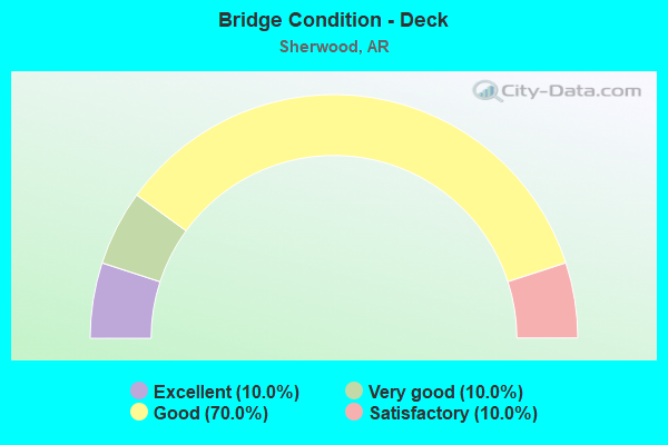
- Bridge Condition - Deck
- 10.0%Excellent
- 10.0%Very good
- 70.0%Good
- 10.0%Satisfactory
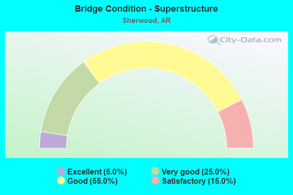
- Bridge Condition - Superstructure
- 5.0%Excellent
- 25.0%Very good
- 55.0%Good
- 15.0%Satisfactory
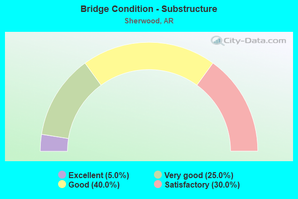
- Bridge Condition - Substructure
- 5.0%Excellent
- 25.0%Very good
- 40.0%Good
- 30.0%Satisfactory
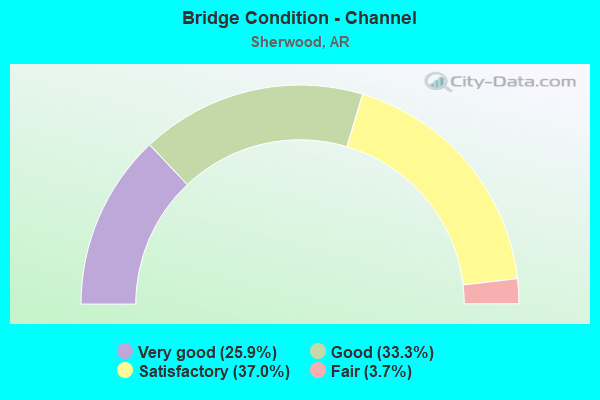
- Bridge Condition - Channel
- 25.9%Very good
- 33.3%Good
- 37.0%Satisfactory
- 3.7%Fair
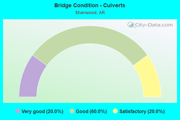
- Bridge Condition - Culverts
- 20.0%Very good
- 60.0%Good
- 20.0%Satisfactory
Find on map >> Show street view
Structure Number: 2347, Location: 0.05 Mi E AshleyC-Montros (Lat: 33.299808, Lng: -91.458378), Route carried "on" structure: US 82, Year Built: 1950, Status: Open, Structure Length: 1.90m (6.23ft), Average Daily Traffic: 2,196 (year 2018), Truck Traffic: 1%, Average Future Daily Traffic: 2,503 (year 2028), Design Load: H 20, Features Intersected: Wards Creek
Minimum Vertical Clearance: 30+ m (98+ ft), Kilometerpoint: 0.080, Lanes on structure: 2, Base Highway Network: Yes, Owner: State Highway Agency, Approaching Roadway Width: 9.8m (32.2ft), Material/Design: Steel, Design/Construction: Stringer/Multi-beam, Number Of Spans In Main Unit: 2, Length of Maximum Span: 9.1m (29.9ft), Curb or Sidewalk Widths: Left: 0.4m (1.3ft), Right: 0.4m (1.3ft), Curb-To-Curb Width: 7.9m (25.9ft), Out-to-Out Width: 9.0m (29.5ft)
Condition: Deck: Good, Superstructure: Satisfactory, Substructure: Satisfactory, Channel: Satisfactory, Operating Rating: 43.5 metric tons, Method Used To Determine Operating Rating: Load Factor (LF), Inventory Rating: 26.3 metric tons, Method Used To Determine Inventory Rating: Load Factor (LF), Structural Evaluation: Equal to present minimum criteria, Deck Geometry: High priority of corrective action, Waterway Adequacy: Equal to present desirable criteria, Approach Roadway Alignment: Equal to present desirable criteria, Length Of Structure Improvement: 2.65m (8.69ft), Designated Inspection Frequency: Every 24 months, Critical Feature Inspection Frequency: Every 24 months, Inspection Date: April 2021, Roadway Improvement Cost: $235,000, Total Project Cost: $476,000, Deck Structure Type: Concrete Cast-file-Place, Wearing Surface/Protective System: Wearing Surface: Bituminous
Find on map >> Show street view
Structure Number: 4392, Location: 1.5 W SH 107&70 (Lat: 34.914639, Lng: -92.196167), Route carried "on" structure: County highway 70, Year Built: 1980, Status: Open, Structure Length: 5.94m (19.49ft), Average Daily Traffic: 1,274 (year 2018), Truck Traffic: 1%, Average Future Daily Traffic: 391 (year 2007), Design Load: H 15, Features Intersected: BAYOU METO
Minimum Vertical Clearance: 30+ m (98+ ft), Kilometerpoint: 2.672, Lanes on structure: 2, Owner: County Highway Agency, Approaching Roadway Width: 7.3m (24.0ft), Material/Design: Steel, Design/Construction: Stringer/Multi-beam, Number Of Spans In Main Unit: 3, Length of Maximum Span: 19.8m (65.0ft), Curb-To-Curb Width: 7.3m (24.0ft), Out-to-Out Width: 8.2m (26.9ft)
Condition: Deck: Good, Superstructure: Good, Substructure: Satisfactory, Channel: Satisfactory, Operating Rating: 43.5 metric tons, Method Used To Determine Operating Rating: Load Factor (LF), Inventory Rating: 26.3 metric tons, Method Used To Determine Inventory Rating: Load Factor (LF), Structural Evaluation: Equal to present minimum criteria, Deck Geometry: Meets minimum limits, Waterway Adequacy: Equal to present desirable criteria, Approach Roadway Alignment: Equal to present desirable criteria, Designated Inspection Frequency: Every 24 months, Critical Feature Inspection Frequency: Every 24 months, Inspection Date: July 2020, Deck Structure Type: Concrete Cast-file-Place, Wearing Surface/Protective System: Wearing Surface: Bituminous
Find on map >> Show street view
Structure Number: 4614, Location: 2.75 MI W US 67 I-1 (Lat: 34.868811, Lng: -92.171869), Route carried "on" structure: City street 28880, Year Built: 1991, Status: Open, Structure Length: 6.00m (19.69ft), Average Daily Traffic: 6,800 (year 2018), Truck Traffic: 1%, Average Future Daily Traffic: 648 (year 2010), Design Load: HS 20, Features Intersected: BAYOU METO, Facility Carried by Structure: JACKSONVILLE CUTOF
Minimum Vertical Clearance: 30+ m (98+ ft), Kilometerpoint: 1.336, Lanes on structure: 2, Owner: City or Municipal Highway Agency, Approaching Roadway Width: 14.6m (47.9ft), Material/Design: Steel, Design/Construction: Stringer/Multi-beam, Number Of Spans In Main Unit: 3, Length of Maximum Span: 19.8m (65.0ft), Curb-To-Curb Width: 14.6m (47.9ft), Out-to-Out Width: 15.5m (50.9ft)
Condition: Deck: Good, Superstructure: Good, Substructure: Very good, Channel: Satisfactory, Operating Rating: 54.4 metric tons, Method Used To Determine Operating Rating: Load Factor (LF), Inventory Rating: 32.7 metric tons, Method Used To Determine Inventory Rating: Load Factor (LF), Structural Evaluation: Better than present minimum criteria, Deck Geometry: Superior to present desirable criteria, Waterway Adequacy: Equal to present desirable criteria, Approach Roadway Alignment: Equal to present desirable criteria, Designated Inspection Frequency: Every 24 months, Critical Feature Inspection Frequency: Every 24 months, Inspection Date: September 2021, Deck Structure Type: Concrete Cast-file-Place, Wearing Surface/Protective System: Wearing Surface: Monolithic Concrete
Find on map >> Show street view
Structure Number: 4942, Location: 1 Mi S of Jx Cutoff (Lat: 34.853278, Lng: -92.172300), Route carried "on" structure: City street 42850, Year Built: 2020, Status: Open, Structure Length: 3.99m (13.09ft), Average Daily Traffic: 1,900 (year 2019), Average Future Daily Traffic: 2,280 (year 2040), Design Load: HL 93, Features Intersected: Kellogg Creek, Facility Carried by Structure: Onedia Drive
Minimum Vertical Clearance: 30+ m (98+ ft), Kilometerpoint: 2.961, Lanes on structure: 2, Owner: City or Municipal Highway Agency, Approaching Roadway Width: 12.0m (39.4ft), Material/Design: Concrete, Design/Construction: Channel Beam, Number Of Spans In Main Unit: 5, Length of Maximum Span: 9.4m (30.8ft), Curb or Sidewalk Widths: Left: 2.6m (8.5ft), Right: 2.6m (8.5ft), Curb-To-Curb Width: 11.7m (38.4ft), Out-to-Out Width: 12.5m (41.0ft)
Condition: Deck: Excellent, Superstructure: Very good, Substructure: Very good, Channel: Very good, Operating Rating: 41.7 metric tons, Method Used To Determine Operating Rating: Load and Resistance Factor (LRFR), Inventory Rating: 31.8 metric tons, Method Used To Determine Inventory Rating: Load and Resistance Factor (LRFR), Structural Evaluation: Better than present minimum criteria, Deck Geometry: Equal to present minimum criteria, Waterway Adequacy: Equal to present desirable criteria, Approach Roadway Alignment: Equal to present desirable criteria, Designated Inspection Frequency: Every 24 months, Critical Feature Inspection Frequency: Every 24 months, Inspection Date: January 2021, Deck Structure Type: Concrete Precast Panels, Wearing Surface/Protective System: Wearing Surface: Monolithic Concrete
Find on map >> Show street view
Structure Number: 6395, Location: 3.24 MI N OF I-40 (Lat: 34.813989, Lng: -92.203119), Route carried "on" structure: US 67, Year Built: 1993, Status: Open, Structure Length: 6.64m (21.78ft), Average Daily Traffic: 76,603 (year 2018), Truck Traffic: 1%, Average Future Daily Traffic: 14,776 (year 2026), Design Load: HS 20, Features Intersected: WILDWOOD AVE
Minimum Vertical Clearance: 30+ m (98+ ft), Kilometerpoint: 5.246, Lanes on structure: 7, Lanes under structure: 5, Base Highway Network: Yes, Owner: State Highway Agency, Approaching Roadway Width: 15.8m (51.8ft), Skew: 33 degrees, Material/Design: Steel continuous, Design/Construction: Stringer/Multi-beam, Number Of Spans In Main Unit: 3, Length of Maximum Span: 27.4m (89.9ft), Curb-To-Curb Width: 36.6m (120.1ft), Out-to-Out Width: 38.0m (124.7ft)
Condition: Deck: Good, Superstructure: Very good, Substructure: Good, Operating Rating: 43.5 metric tons, Method Used To Determine Operating Rating: Load Factor (LF), Inventory Rating: 26.3 metric tons, Method Used To Determine Inventory Rating: Load Factor (LF), Structural Evaluation: Equal to present minimum criteria, Deck Geometry: Superior to present desirable criteria, Underclear: High priority of corrective action, Approach Roadway Alignment: Equal to present desirable criteria, Designated Inspection Frequency: Every 24 months, Critical Feature Inspection Frequency: Every 24 months, Inspection Date: October 2021, Deck Structure Type: Concrete Cast-file-Place, Wearing Surface/Protective System: Wearing Surface: Monolithic Concrete
Find on map >> Show street view
Structure Number: 6942, Location: 2 Mi N of I-40 (Lat: 34.802050, Lng: -92.213869), Route carried "on" structure: US 67, Year Built: 2004, Status: Open, Structure Length: 49.60m (162.73ft), Average Daily Traffic: 82,000 (year 2018), Truck Traffic: 1%, Average Future Daily Traffic: 14,776 (year 2026), Design Load: HS 20, Features Intersected: Five Mile Creek & SR
Minimum Vertical Clearance: 30+ m (98+ ft), Kilometerpoint: 3.557, Lanes on structure: 6, Lanes under structure: 2, Base Highway Network: Yes, Owner: State Highway Agency, Approaching Roadway Width: 34.1m (111.9ft), Skew: 30 degrees, Material/Design: Steel continuous, Design/Construction: Stringer/Multi-beam, Number Of Spans In Main Unit: 27, Length of Maximum Span: 38.1m (125.0ft), Curb-To-Curb Width: 34.1m (111.9ft), Out-to-Out Width: 35.7m (117.1ft)
Condition: Deck: Good, Superstructure: Good, Substructure: Good, Channel: Good, Operating Rating: 54.4 metric tons, Method Used To Determine Operating Rating: Load Factor (LF), Inventory Rating: 32.7 metric tons, Method Used To Determine Inventory Rating: Load Factor (LF), Structural Evaluation: Better than present minimum criteria, Deck Geometry: Superior to present desirable criteria, Waterway Adequacy: Equal to present desirable criteria, Approach Roadway Alignment: Equal to present desirable criteria, Designated Inspection Frequency: Every 24 months, Critical Feature Inspection Frequency: Every 24 months, Inspection Date: June 2021, Deck Structure Type: Concrete Cast-file-Place, Wearing Surface/Protective System: Wearing Surface: Monolithic Concrete, Deck Protection: Epoxy Coated Reinforcing
Find on map >> Show street view
Structure Number: 7051, Location: 3.8 Mi N of I-40 (Lat: 34.820911, Lng: -92.196889), Route carried "on" structure: US 67, Year Built: 2007, Status: Open, Structure Length: 5.41m (17.75ft), Average Daily Traffic: 76,603 (year 2018), Truck Traffic: 1%, Average Future Daily Traffic: 81,659 (year 2028), Design Load: HS 20, Features Intersected: Woodruff Creek
Minimum Vertical Clearance: 30+ m (98+ ft), Kilometerpoint: 6.180, Lanes on structure: 6, Base Highway Network: Yes, Owner: State Highway Agency, Approaching Roadway Width: 34.1m (111.9ft), Skew: 33 degrees, Material/Design: Steel continuous, Design/Construction: Stringer/Multi-beam, Number Of Spans In Main Unit: 5, Length of Maximum Span: 11.3m (37.1ft), Curb-To-Curb Width: 34.1m (111.9ft), Out-to-Out Width: 35.7m (117.1ft)
Condition: Deck: Good, Superstructure: Good, Substructure: Good, Channel: Good, Operating Rating: 54.4 metric tons, Method Used To Determine Operating Rating: Load Factor (LF), Inventory Rating: 32.7 metric tons, Method Used To Determine Inventory Rating: Load Factor (LF), Structural Evaluation: Better than present minimum criteria, Deck Geometry: Superior to present desirable criteria, Waterway Adequacy: Equal to present desirable criteria, Approach Roadway Alignment: Equal to present desirable criteria, Designated Inspection Frequency: Every 24 months, Critical Feature Inspection Frequency: Every 24 months, Inspection Date: June 2021, Deck Structure Type: Concrete Cast-file-Place, Wearing Surface/Protective System: Wearing Surface: Monolithic Concrete, Deck Protection: Epoxy Coated Reinforcing
Find on map >> Show street view
Structure Number: 7052, Location: 0.4 Mi S of Kiehl Ave. (Lat: 34.826600, Lng: -92.189800), Route carried "on" structure: Ramp US 67, Year Built: 2006, Status: Open, Structure Length: 14.94m (49.02ft), Average Daily Traffic: 13,949 (year 2011), Truck Traffic: 1%, Average Future Daily Traffic: 14,776 (year 2026), Design Load: HS 20, Features Intersected: US 67
Minimum Vertical Clearance: 30+ m (98+ ft), Kilometerpoint: 7.451, Lanes on structure: 1, Lanes under structure: 9, Owner: State Highway Agency, Approaching Roadway Width: 7.6m (24.9ft), Material/Design: Steel continuous, Design/Construction: Stringer/Multi-beam, Number Of Spans In Main Unit: 3, Length of Maximum Span: 56.1m (184.1ft), Curb-To-Curb Width: 7.6m (24.9ft), Out-to-Out Width: 8.5m (27.9ft)
Condition: Deck: Very good, Superstructure: Very good, Substructure: Very good, Operating Rating: 54.4 metric tons, Method Used To Determine Operating Rating: Load Factor (LF), Inventory Rating: 32.7 metric tons, Method Used To Determine Inventory Rating: Load Factor (LF), Structural Evaluation: Equal to present desirable criteria, Deck Geometry: Better than present minimum criteria, Underclear: High priority of corrective action, Approach Roadway Alignment: Equal to present desirable criteria, Designated Inspection Frequency: Every 24 months, Critical Feature Inspection Frequency: Every 24 months, Inspection Date: Febuary 2022, Deck Structure Type: Concrete Cast-file-Place, Wearing Surface/Protective System: Deck Protection: Epoxy Coated Reinforcing
Find on map >> Show street view
Structure Number: 7053, Location: 5 Mi N of I-40 (Lat: 34.830719, Lng: -92.181639), Route carried "on" structure: State highway 176, Year Built: 2007, Status: Open, Structure Length: 9.70m (31.82ft), Average Daily Traffic: 16,000 (year 2018), Truck Traffic: 1%, Average Future Daily Traffic: 19,443 (year 2028), Design Load: HS 20, Features Intersected: US 67 Log 4.95
Minimum Vertical Clearance: 30+ m (98+ ft), Kilometerpoint: 4.651, Lanes on structure: 2, Lanes under structure: 10, Owner: State Highway Agency, Approaching Roadway Width: 17.7m (58.1ft), Skew: 20 degrees, Material/Design: Steel continuous, Design/Construction: Stringer/Multi-beam, Number Of Spans In Main Unit: 4, Length of Maximum Span: 24.1m (79.1ft), Curb or Sidewalk Widths: Left: 1.8m (5.9ft), Right: 1.8m (5.9ft), Curb-To-Curb Width: 17.7m (58.1ft), Out-to-Out Width: 22.3m (73.2ft)
Condition: Deck: Good, Superstructure: Very good, Substructure: Very good, Operating Rating: 54.4 metric tons, Method Used To Determine Operating Rating: Load Factor (LF), Inventory Rating: 32.7 metric tons, Method Used To Determine Inventory Rating: Load Factor (LF), Structural Evaluation: Equal to present desirable criteria, Deck Geometry: Superior to present desirable criteria, Underclear: Equal to present minimum criteria, Approach Roadway Alignment: Equal to present desirable criteria, Designated Inspection Frequency: Every 24 months, Critical Feature Inspection Frequency: Every 24 months, Inspection Date: March 2021, Deck Structure Type: Concrete Cast-file-Place, Wearing Surface/Protective System: Wearing Surface: Monolithic Concrete, Deck Protection: Epoxy Coated Reinforcing
Find on map >> Show street view
Structure Number: 165, Location: .2 W SH 107 (I-1) (Lat: 34.872972, Lng: -92.200972), Route carried "on" structure: City street 28870, Year Built: 1950, Status: Open, Structure Length: 0.98m (3.22ft), Average Daily Traffic: 3,475 (year 2018), Truck Traffic: 1%, Average Future Daily Traffic: 5,847 (year 2007), Features Intersected: KELLOGG CREEK, Facility Carried by Structure: J'ville-Cato Road
Minimum Vertical Clearance: 30+ m (98+ ft), Kilometerpoint: 0.386, Lanes on structure: 2, Owner: City or Municipal Highway Agency, Approaching Roadway Width: 6.7m (22.0ft), Material/Design: Concrete, Design/Construction: Slab, Number Of Spans In Main Unit: 2, Length of Maximum Span: 4.0m (13.1ft), Curb or Sidewalk Widths: Left: 0.2m (0.7ft), Right: 0.2m (0.7ft), Curb-To-Curb Width: 7.4m (24.3ft), Out-to-Out Width: 7.9m (25.9ft)
Condition: Deck: Good, Superstructure: Good, Substructure: Satisfactory, Channel: Satisfactory, Operating Rating: 29.9 metric tons, Method Used To Determine Operating Rating: Load Factor (LF), Inventory Rating: 18.1 metric tons, Method Used To Determine Inventory Rating: Load Factor (LF), Structural Evaluation: Somewhat better than minimum adequacy, Deck Geometry: High priority of replacement, Waterway Adequacy: Equal to present minimum criteria, Approach Roadway Alignment: Better than present minimum criteria, Length Of Structure Improvement: 1.68m (5.51ft), Designated Inspection Frequency: Every 24 months, Critical Feature Inspection Frequency: Every 24 months, Inspection Date: July 2020, Roadway Improvement Cost: $125,000, Total Project Cost: $249,000, Deck Structure Type: Concrete Cast-file-Place, Wearing Surface/Protective System: Wearing Surface: Bituminous
Find on map >> Show street view
Structure Number: 16501, Location: 1.58 MI W SH 107(I-1) (Lat: 34.881833, Lng: -92.218722), Route carried "on" structure: City street 28870, Year Built: 1950, Status: Open, Structure Length: 1.48m (4.86ft), Average Daily Traffic: 3,700 (year 2018), Truck Traffic: 3%, Average Future Daily Traffic: 5,847 (year 2007), Features Intersected: BRNCH OF KELLOGG CREEK, Facility Carried by Structure: J' ville-Cato Rd
Minimum Vertical Clearance: 30+ m (98+ ft), Kilometerpoint: 2.543, Lanes on structure: 2, Owner: City or Municipal Highway Agency, Approaching Roadway Width: 7.3m (24.0ft), Material/Design: Concrete, Design/Construction: Slab, Number Of Spans In Main Unit: 3, Length of Maximum Span: 4.3m (14.1ft), Curb or Sidewalk Widths: Left: 0.2m (0.7ft), Right: 0.2m (0.7ft), Curb-To-Curb Width: 7.4m (24.3ft), Out-to-Out Width: 7.9m (25.9ft)
Condition: Deck: Good, Superstructure: Good, Substructure: Good, Channel: Fair, Operating Rating: 29.9 metric tons, Method Used To Determine Operating Rating: Load Factor (LF), Inventory Rating: 18.1 metric tons, Method Used To Determine Inventory Rating: Load Factor (LF), Structural Evaluation: Somewhat better than minimum adequacy, Deck Geometry: High priority of replacement, Waterway Adequacy: Equal to present desirable criteria, Approach Roadway Alignment: Equal to present minimum criteria, Length Of Structure Improvement: 2.19m (7.19ft), Designated Inspection Frequency: Every 24 months, Critical Feature Inspection Frequency: Every 24 months, Inspection Date: July 2020, Roadway Improvement Cost: $125,000, Total Project Cost: $277,000, Deck Structure Type: Concrete Cast-file-Place, Wearing Surface/Protective System: Wearing Surface: Bituminous
Find on map >> Show street view
Structure Number: 16573, Location: 1.33 E SH 107 (I-1) (Lat: 34.829528, Lng: -92.210639), Route carried "on" structure: City street 32830, Year Built: 1969, Status: Open, Structure Length: 0.84m (2.76ft), Average Daily Traffic: 1,900 (year 2018), Truck Traffic: 1%, Average Future Daily Traffic: 187 (year 2007), Features Intersected: BRANCH, Facility Carried by Structure: LEE AVE
Minimum Vertical Clearance: 30+ m (98+ ft), Kilometerpoint: 2.140, Lanes on structure: 2, Owner: City or Municipal Highway Agency, Approaching Roadway Width: 7.3m (24.0ft), Material/Design: Steel, Design/Construction: Stringer/Multi-beam, Number Of Spans In Main Unit: 1, Length of Maximum Span: 7.5m (24.6ft), Curb or Sidewalk Widths: Left: 0.2m (0.7ft), Right: 0.2m (0.7ft), Curb-To-Curb Width: 7.4m (24.3ft), Out-to-Out Width: 7.8m (25.6ft)
Condition: Deck: Good, Superstructure: Good, Substructure: Satisfactory, Channel: Very good, Operating Rating: 34.5 metric tons, Method Used To Determine Operating Rating: Load Factor (LF), Inventory Rating: 20.9 metric tons, Method Used To Determine Inventory Rating: Load Factor (LF), Structural Evaluation: Somewhat better than minimum adequacy, Deck Geometry: Meets minimum limits, Waterway Adequacy: Equal to present desirable criteria, Approach Roadway Alignment: Equal to present minimum criteria, Designated Inspection Frequency: Every 24 months, Critical Feature Inspection Frequency: Every 24 months, Inspection Date: July 2020, Deck Structure Type: Concrete Cast-file-Place, Wearing Surface/Protective System: Wearing Surface: Bituminous
Find on map >> Show street view
Structure Number: 19676, Location: .3 N CTRY CLUB RD(I-6) (Lat: 34.822803, Lng: -92.219528), Route carried "on" structure: City street 4880, Year Built: 1973, Status: Open, Structure Length: 1.89m (6.20ft), Average Daily Traffic: 585 (year 2018), Truck Traffic: 1%, Average Future Daily Traffic: 441 (year 2007), Features Intersected: WOODRUFF CREEK, Facility Carried by Structure: N BEVERLY STREET
Minimum Vertical Clearance: 30+ m (98+ ft), Kilometerpoint: 0.145, Lanes on structure: 2, Owner: City or Municipal Highway Agency, Approaching Roadway Width: 7.9m (25.9ft), Material/Design: Concrete, Design/Construction: Channel Beam, Number Of Spans In Main Unit: 2, Length of Maximum Span: 8.8m (28.9ft), Curb or Sidewalk Widths: Left: 0.3m (1.0ft), Right: 0.3m (1.0ft), Curb-To-Curb Width: 8.0m (26.2ft), Out-to-Out Width: 8.6m (28.2ft)
Condition: Deck: Satisfactory, Superstructure: Satisfactory, Substructure: Satisfactory, Channel: Good, Operating Rating: 43.5 metric tons, Method Used To Determine Operating Rating: Load Factor (LF), Inventory Rating: 26.3 metric tons, Method Used To Determine Inventory Rating: Load Factor (LF), Structural Evaluation: Equal to present minimum criteria, Deck Geometry: Somewhat better than minimum adequacy, Waterway Adequacy: Equal to present desirable criteria, Approach Roadway Alignment: Equal to present desirable criteria, Designated Inspection Frequency: Every 24 months, Critical Feature Inspection Frequency: Every 24 months, Inspection Date: July 2020, Deck Structure Type: Concrete Precast Panels, Wearing Surface/Protective System: Wearing Surface: Bituminous
Find on map >> Show street view
Structure Number: 19677, Location: .12 E CLUB LANE (I-6) (Lat: 34.824069, Lng: -92.213050), Route carried "on" structure: City street 62795, Year Built: 1970, Status: Open, Structure Length: 0.92m (3.02ft), Average Daily Traffic: 130 (year 2018), Truck Traffic: 1%, Average Future Daily Traffic: 468 (year 2007), Features Intersected: WOODRUFF CREEK, Facility Carried by Structure: WINDCHIME
Minimum Vertical Clearance: 30+ m (98+ ft), Kilometerpoint: 0.193, Lanes on structure: 2, Owner: City or Municipal Highway Agency, Approaching Roadway Width: 8.5m (27.9ft), Material/Design: Concrete, Design/Construction: Slab, Number Of Spans In Main Unit: 3, Length of Maximum Span: 3.0m (9.8ft), Curb-To-Curb Width: 9.0m (29.5ft), Out-to-Out Width: 9.3m (30.5ft)
Condition: Deck: Good, Superstructure: Good, Substructure: Good, Channel: Good, Operating Rating: 21.8 metric tons, Method Used To Determine Operating Rating: Load Factor (LF), Inventory Rating: 13.6 metric tons, Method Used To Determine Inventory Rating: Load Factor (LF), Structural Evaluation: Meets minimum limits, Deck Geometry: Equal to present minimum criteria, Waterway Adequacy: Meets minimum limits, Approach Roadway Alignment: Equal to present minimum criteria, Length Of Structure Improvement: 0.88m (2.89ft), Designated Inspection Frequency: Every 24 months, Critical Feature Inspection Frequency: Every 24 months, Inspection Date: October 2021, Total Project Cost: $40,000, Deck Structure Type: Concrete Cast-file-Place, Wearing Surface/Protective System: Wearing Surface: Monolithic Concrete
Find on map >> Show street view
Structure Number: 19678, Location: .54 E SH 107 (I-1) (Lat: 34.825664, Lng: -92.222258), Route carried "on" structure: City street 11890, Year Built: 1970, Status: Open, Structure Length: 0.94m (3.08ft), Average Daily Traffic: 3,100 (year 2018), Truck Traffic: 1%, Average Future Daily Traffic: 1,912 (year 2007), Features Intersected: WOODRUFF CREEK, Facility Carried by Structure: CLUB ROAD ZONE C
Minimum Vertical Clearance: 30+ m (98+ ft), Kilometerpoint: 0.869, Lanes on structure: 2, Owner: City or Municipal Highway Agency, Approaching Roadway Width: 6.7m (22.0ft), Material/Design: Concrete, Design/Construction: Channel Beam, Number Of Spans In Main Unit: 1, Length of Maximum Span: 8.5m (27.9ft), Curb or Sidewalk Widths: Left: 0.3m (1.0ft), Right: 0.3m (1.0ft), Curb-To-Curb Width: 7.3m (24.0ft), Out-to-Out Width: 8.0m (26.2ft)
Condition: Deck: Good, Superstructure: Good, Substructure: Good, Channel: Good, Operating Rating: 44.5 metric tons, Method Used To Determine Operating Rating: Load Factor (LF), Inventory Rating: 26.3 metric tons, Method Used To Determine Inventory Rating: Load Factor (LF), Structural Evaluation: Equal to present minimum criteria, Deck Geometry: High priority of replacement, Waterway Adequacy: Equal to present desirable criteria, Approach Roadway Alignment: Equal to present desirable criteria, Designated Inspection Frequency: Every 24 months, Critical Feature Inspection Frequency: Every 24 months, Inspection Date: June 2020, Deck Structure Type: Concrete Precast Panels, Wearing Surface/Protective System: Wearing Surface: Bituminous
Find on map >> Show street view
Structure Number: 19706, Location: 0.2 Mi N of SH 176 (Lat: 34.834639, Lng: -92.209778), Route carried "on" structure: City street 57640, Year Built: 1979, Status: Open, Structure Length: 0.94m (3.08ft), Average Daily Traffic: 341 (year 2018), Truck Traffic: 1%, Average Future Daily Traffic: 3,484 (year 2007), Features Intersected: BRANCH, Facility Carried by Structure: THORNHILL DRIVE
Minimum Vertical Clearance: 30+ m (98+ ft), Kilometerpoint: 0.064, Lanes on structure: 2, Owner: City or Municipal Highway Agency, Approaching Roadway Width: 8.5m (27.9ft), Material/Design: Concrete, Design/Construction: Channel Beam, Number Of Spans In Main Unit: 1, Length of Maximum Span: 8.5m (27.9ft), Curb or Sidewalk Widths: Left: 1.2m (3.9ft), Right: 0.3m (1.0ft), Curb-To-Curb Width: 8.5m (27.9ft), Out-to-Out Width: 10.5m (34.4ft)
Condition: Deck: Good, Superstructure: Good, Substructure: Satisfactory, Channel: Satisfactory, Operating Rating: 41.7 metric tons, Method Used To Determine Operating Rating: Load Factor (LF), Inventory Rating: 25.4 metric tons, Method Used To Determine Inventory Rating: Load Factor (LF), Structural Evaluation: Equal to present minimum criteria, Deck Geometry: Equal to present minimum criteria, Waterway Adequacy: Better than present minimum criteria, Approach Roadway Alignment: Equal to present desirable criteria, Length Of Structure Improvement: 1.65m (5.41ft), Designated Inspection Frequency: Every 24 months, Critical Feature Inspection Frequency: Every 24 months, Inspection Date: July 2020, Roadway Improvement Cost: $206,000, Total Project Cost: $358,000, Deck Structure Type: Concrete Cast-file-Place, Wearing Surface/Protective System: Wearing Surface: Bituminous
Find on map >> Show street view
Structure Number: 1975, Location: .10 MI W OF JCT SH107/I-1 (Lat: 34.840481, Lng: -92.233169), Route carried "on" structure: City street 36410, Year Built: 1975, Status: Open, Structure Length: 0.67m (2.20ft), Average Daily Traffic: 7,452 (year 2017), Truck Traffic: 3%, Average Future Daily Traffic: 132 (year 2007), Features Intersected: WOODRUFF CREEK, Facility Carried by Structure: W MARYLAND AVE.
Minimum Vertical Clearance: 30+ m (98+ ft), Kilometerpoint: 0.161, Lanes on structure: 3, Owner: City or Municipal Highway Agency, Approaching Roadway Width: 8.5m (27.9ft), Material/Design: Concrete, Design/Construction: Culvert, Number Of Spans In Main Unit: 2, Length of Maximum Span: 3.0m (9.8ft), Curb or Sidewalk Widths: Left: 1.7m (5.6ft), Right: 0.0m
Condition: Channel: Good, Culverts: Satisfactory, Operating Rating: 30.8 metric tons, Method Used To Determine Operating Rating: Load Factor (LF), Inventory Rating: 18.1 metric tons, Method Used To Determine Inventory Rating: Load Factor (LF), Structural Evaluation: Meets minimum limits, Waterway Adequacy: Equal to present desirable criteria, Approach Roadway Alignment: Equal to present desirable criteria, Designated Inspection Frequency: Every 24 months, Critical Feature Inspection Frequency: Every 24 months, Inspection Date: June 2020
Find on map >> Show street view
Structure Number: 19773, Location: .3 Mi N of SH176 (Lat: 34.836664, Lng: -92.210356), Route carried "on" structure: City street 2620, Year Built: 1978, Status: Open, Structure Length: 0.76m (2.49ft), Average Daily Traffic: 583 (year 2018), Truck Traffic: 1%, Average Future Daily Traffic: 3,484 (year 2007), Features Intersected: BRANCH, Facility Carried by Structure: AUTUMNBROOK CR
Minimum Vertical Clearance: 30+ m (98+ ft), Kilometerpoint: 0.129, Lanes on structure: 2, Owner: City or Municipal Highway Agency, Approaching Roadway Width: 8.5m (27.9ft), Material/Design: Concrete, Design/Construction: Channel Beam, Number Of Spans In Main Unit: 1, Length of Maximum Span: 7.3m (24.0ft), Curb or Sidewalk Widths: Left: 0.2m (0.7ft), Right: 1.4m (4.6ft), Curb-To-Curb Width: 8.4m (27.6ft), Out-to-Out Width: 8.4m (27.6ft)
Condition: Deck: Good, Superstructure: Good, Substructure: Good, Channel: Very good, Operating Rating: 54.4 metric tons, Method Used To Determine Operating Rating: Load Factor (LF), Inventory Rating: 32.7 metric tons, Method Used To Determine Inventory Rating: Load Factor (LF), Structural Evaluation: Better than present minimum criteria, Deck Geometry: Somewhat better than minimum adequacy, Waterway Adequacy: Better than present minimum criteria, Approach Roadway Alignment: Equal to present desirable criteria, Length Of Structure Improvement: 1.46m (4.79ft), Designated Inspection Frequency: Every 24 months, Critical Feature Inspection Frequency: Every 24 months, Inspection Date: July 2020, Roadway Improvement Cost: $202,000, Total Project Cost: $340,000, Deck Structure Type: Concrete Cast-file-Place, Wearing Surface/Protective System: Wearing Surface: Monolithic Concrete
Find on map >> Show street view
Structure Number: 20617, Location: 0.5 Mi N of Old Tom Box (Lat: 34.923056, Lng: -92.194969), Route carried "on" structure: County highway 693, Year Built: 1988, Status: Open, Structure Length: 1.89m (6.20ft), Average Daily Traffic: 200 (year 2018), Truck Traffic: 1%, Average Future Daily Traffic: 87 (year 2007), Design Load: HS 20, Features Intersected: BAYOU METO, Facility Carried by Structure: Jim Hall Rd
Minimum Vertical Clearance: 30+ m (98+ ft), Kilometerpoint: 0.805, Lanes on structure: 2, Owner: County Highway Agency, Approaching Roadway Width: 5.5m (18.0ft), Material/Design: Concrete, Design/Construction: Channel Beam, Number Of Spans In Main Unit: 2, Length of Maximum Span: 8.5m (27.9ft), Curb-To-Curb Width: 7.9m (25.9ft), Out-to-Out Width: 8.3m (27.2ft)
Condition: Deck: Very good, Superstructure: Very good, Substructure: Very good, Channel: Satisfactory, Operating Rating: 44.5 metric tons, Method Used To Determine Operating Rating: Load Factor (LF), Inventory Rating: 27.2 metric tons, Method Used To Determine Inventory Rating: Load Factor (LF), Structural Evaluation: Equal to present minimum criteria, Deck Geometry: Somewhat better than minimum adequacy, Waterway Adequacy: Equal to present minimum criteria, Approach Roadway Alignment: Equal to present desirable criteria, Designated Inspection Frequency: Every 24 months, Critical Feature Inspection Frequency: Every 24 months, Inspection Date: July 2020, Deck Structure Type: Concrete Precast Panels, Wearing Surface/Protective System: Wearing Surface: Monolithic Concrete
Find on map >> Show street view
Structure Number: 21385, Location: .1 MILES W US 67 (Lat: 34.814350, Lng: -92.205181), Route carried "on" structure: City street 62350, Year Built: 1993, Status: Open, Structure Length: 0.80m (2.62ft), Average Daily Traffic: 16,000 (year 2018), Truck Traffic: 1%, Average Future Daily Traffic: 17,750 (year 2032), Design Load: H 20, Features Intersected: DITCH, Facility Carried by Structure: WILDWOOD AVE
Minimum Vertical Clearance: 30+ m (98+ ft), Kilometerpoint: 3.701, Lanes on structure: 5, Owner: City or Municipal Highway Agency, Approaching Roadway Width: 18.3m (60.0ft), Material/Design: Concrete, Design/Construction: Culvert, Number Of Spans In Main Unit: 3, Length of Maximum Span: 2.4m (7.9ft), Curb or Sidewalk Widths: Left: 1.8m (5.9ft), Right: 0.0m, Curb-To-Curb Width: 25.6m (84.0ft), Out-to-Out Width: 26.2m (86.0ft)
Condition: Channel: Satisfactory, Culverts: Good, Operating Rating: 47.2 metric tons, Method Used To Determine Operating Rating: Load Factor (LF), Inventory Rating: 28.1 metric tons, Method Used To Determine Inventory Rating: Load Factor (LF), Structural Evaluation: Better than present minimum criteria, Deck Geometry: Superior to present desirable criteria, Waterway Adequacy: Equal to present desirable criteria, Approach Roadway Alignment: Equal to present desirable criteria, Designated Inspection Frequency: Every 24 months, Critical Feature Inspection Frequency: Every 24 months, Inspection Date: October 2021
Find on map >> Show street view
Structure Number: 21758, Location: .30 MI E OF US 67/I-6 (Lat: 34.813800, Lng: -92.196783), Route carried "on" structure: City street 58370, Year Built: 1996, Status: Open, Structure Length: 2.83m (9.28ft), Average Daily Traffic: 1,800 (year 2018), Truck Traffic: 3%, Average Future Daily Traffic: 2,200 (year 2038), Design Load: HS 20, Features Intersected: FIVE MILE CREEK, Facility Carried by Structure: Trammel Rd
Minimum Vertical Clearance: 30+ m (98+ ft), Kilometerpoint: 0.579, Lanes on structure: 2, Owner: City or Municipal Highway Agency, Approaching Roadway Width: 6.7m (22.0ft), Material/Design: Concrete, Design/Construction: Channel Beam, Number Of Spans In Main Unit: 3, Length of Maximum Span: 9.4m (30.8ft), Curb-To-Curb Width: 8.5m (27.9ft), Out-to-Out Width: 9.3m (30.5ft)
Condition: Deck: Satisfactory, Superstructure: Satisfactory, Substructure: Good, Channel: Good, Operating Rating: 54.4 metric tons, Method Used To Determine Operating Rating: Load Factor (LF), Inventory Rating: 32.7 metric tons, Method Used To Determine Inventory Rating: Load Factor (LF), Structural Evaluation: Equal to present minimum criteria, Deck Geometry: Somewhat better than minimum adequacy, Waterway Adequacy: Equal to present minimum criteria, Approach Roadway Alignment: Equal to present desirable criteria, Designated Inspection Frequency: Every 24 months, Critical Feature Inspection Frequency: Every 24 months, Inspection Date: June 2021, Deck Structure Type: Concrete Precast Panels, Wearing Surface/Protective System: Wearing Surface: Monolithic Concrete
Find on map >> Show street view
Structure Number: 21923, Location: .02 E JCT BRONCO LN I-1 (Lat: 34.829019, Lng: -92.210600), Route carried "on" structure: City street 35770, Year Built: 1998, Status: Open, Structure Length: 0.64m (2.10ft), Average Daily Traffic: 111 (year 2018), Average Future Daily Traffic: 43 (year 2007), Features Intersected: BRANCH, Facility Carried by Structure: MANOR DR.
Minimum Vertical Clearance: 30+ m (98+ ft), Kilometerpoint: 0.032, Lanes on structure: 2, Owner: City or Municipal Highway Agency, Approaching Roadway Width: 6.7m (22.0ft), Material/Design: Concrete, Design/Construction: Culvert, Number Of Spans In Main Unit: 2, Length of Maximum Span: 3.0m (9.8ft), Curb or Sidewalk Widths: Left: 0.2m (0.7ft), Right: 0.2m (0.7ft), Curb-To-Curb Width: 8.4m (27.6ft), Out-to-Out Width: 9.1m (29.9ft)
Condition: Channel: Satisfactory, Culverts: Good, Operating Rating: 39.9 metric tons, Method Used To Determine Operating Rating: Load Factor (LF), Inventory Rating: 23.6 metric tons, Method Used To Determine Inventory Rating: Load Factor (LF), Structural Evaluation: Equal to present minimum criteria, Deck Geometry: Somewhat better than minimum adequacy, Waterway Adequacy: Equal to present desirable criteria, Approach Roadway Alignment: Equal to present desirable criteria, Designated Inspection Frequency: Every 24 months, Critical Feature Inspection Frequency: Every 24 months, Inspection Date: September 2021, Deck Structure Type: Concrete Cast-file-Place, Wearing Surface/Protective System: Wearing Surface: Monolithic Concrete
Find on map >> Show street view
Structure Number: 22852, Location: 0.2 Mi S of SH 107 (Lat: 34.851639, Lng: -92.212417), Route carried "on" structure: City street 41775, Year Built: 2004, Status: Open, Structure Length: 0.77m (2.53ft), Average Daily Traffic: 1,961 (year 2018), Truck Traffic: 1%, Average Future Daily Traffic: 389 (year 2024), Features Intersected: Gap Creek, Facility Carried by Structure: Oakbrook Drive
Minimum Vertical Clearance: 30+ m (98+ ft), Kilometerpoint: 0.322, Lanes on structure: 2, Owner: City or Municipal Highway Agency, Approaching Roadway Width: 11.0m (36.1ft), Material/Design: Concrete, Design/Construction: Culvert, Number Of Spans In Main Unit: 3, Length of Maximum Span: 2.4m (7.9ft), Curb or Sidewalk Widths: Left: 2.6m (8.5ft), Right: 2.7m (8.9ft), Curb-To-Curb Width: 11.0m (36.1ft), Out-to-Out Width: 11.0m (36.1ft)
Condition: Channel: Very good, Culverts: Good, Operating Rating: 47.2 metric tons, Method Used To Determine Operating Rating: Load Factor (LF), Inventory Rating: 28.1 metric tons, Method Used To Determine Inventory Rating: Load Factor (LF), Structural Evaluation: Better than present minimum criteria, Deck Geometry: Equal to present minimum criteria, Waterway Adequacy: Equal to present desirable criteria, Approach Roadway Alignment: Equal to present desirable criteria, Designated Inspection Frequency: Every 24 months, Critical Feature Inspection Frequency: Every 24 months, Inspection Date: July 2020
Find on map >> Show street view
Structure Number: 23284, Location: 1.63 MI N US 67 (Lat: 34.852425, Lng: -92.197625), Route carried "on" structure: City street 7145, Year Built: 2010, Status: Open, Structure Length: 0.80m (2.62ft), Average Daily Traffic: 3,031 (year 2018), Truck Traffic: 5%, Average Future Daily Traffic: 22,500 (year 2032), Design Load: H 20, Features Intersected: Gap Creek, Facility Carried by Structure: Brockington Road
Minimum Vertical Clearance: 30+ m (98+ ft), Kilometerpoint: 2.623, Lanes on structure: 4, Owner: City or Municipal Highway Agency, Approaching Roadway Width: 14.6m (47.9ft), Skew: 20 degrees, Material/Design: Concrete, Design/Construction: Culvert, Number Of Spans In Main Unit: 2, Length of Maximum Span: 3.7m (12.1ft), Curb or Sidewalk Widths: Left: 1.2m (3.9ft), Right: 1.2m (3.9ft)
Condition: Channel: Satisfactory, Culverts: Good, Operating Rating: 31.8 metric tons, Method Used To Determine Operating Rating: Load Factor (LF), Inventory Rating: 19.1 metric tons, Method Used To Determine Inventory Rating: Load Factor (LF), Structural Evaluation: Somewhat better than minimum adequacy, Waterway Adequacy: Equal to present desirable criteria, Approach Roadway Alignment: Equal to present desirable criteria, Designated Inspection Frequency: Every 24 months, Critical Feature Inspection Frequency: Every 24 months, Inspection Date: Febuary 2022
Find on map >> Show street view
Structure Number: 23357, Location: 1.1 M E SH 107 (Lat: 34.839919, Lng: -92.211547), Route carried "on" structure: City street 36410, Year Built: 2010, Status: Open, Structure Length: 0.92m (3.02ft), Average Daily Traffic: 3,800 (year 2018), Truck Traffic: 2%, Average Future Daily Traffic: 7,000 (year 2032), Features Intersected: Creek, Facility Carried by Structure: East Maryland Ave.
Minimum Vertical Clearance: 30+ m (98+ ft), Kilometerpoint: 1.770, Lanes on structure: 2, Owner: City or Municipal Highway Agency, Approaching Roadway Width: 10.4m (34.1ft), Skew: 4 degrees, Material/Design: Concrete, Design/Construction: Culvert, Number Of Spans In Main Unit: 3, Length of Maximum Span: 2.6m (8.5ft), Curb or Sidewalk Widths: Left: 1.5m (4.9ft), Right: 0.0m
Condition: Channel: Very good, Culverts: Very good, Operating Rating: 36.3 metric tons, Method Used To Determine Operating Rating: Load Factor (LF), Inventory Rating: 21.8 metric tons, Method Used To Determine Inventory Rating: Load Factor (LF), Structural Evaluation: Somewhat better than minimum adequacy, Waterway Adequacy: Equal to present desirable criteria, Approach Roadway Alignment: Equal to present desirable criteria, Designated Inspection Frequency: Every 24 months, Critical Feature Inspection Frequency: Every 24 months, Inspection Date: March 2022
Find on map >> Show street view
Structure Number: 2347, Location: 0.31 E SH 107 (Lat: 34.830331, Lng: -92.227381), Route carried "on" structure: City street 32830, Year Built: 2011, Status: Open, Structure Length: 0.94m (3.08ft), Average Daily Traffic: 41 (year 2018), Truck Traffic: 2%, Average Future Daily Traffic: 2,100 (year 2038), Design Load: HS 20, Features Intersected: Woodruff Creek, Facility Carried by Structure: Lee Ave.
Minimum Vertical Clearance: 30+ m (98+ ft), Kilometerpoint: 0.499, Lanes on structure: 2, Owner: City or Municipal Highway Agency, Approaching Roadway Width: 5.8m (19.0ft), Material/Design: Concrete, Design/Construction: Channel Beam, Number Of Spans In Main Unit: 1, Length of Maximum Span: 9.4m (30.8ft), Curb or Sidewalk Widths: Left: 0.0m, Right: 2.1m (6.9ft), Curb-To-Curb Width: 8.5m (27.9ft), Out-to-Out Width: 11.8m (38.7ft)
Condition: Deck: Excellent, Superstructure: Excellent, Substructure: Excellent, Channel: Good, Operating Rating: 54.4 metric tons, Method Used To Determine Operating Rating: Load Factor (LF), Inventory Rating: 32.7 metric tons, Method Used To Determine Inventory Rating: Load Factor (LF), Structural Evaluation: Superior to present desirable criteria, Deck Geometry: Better than present minimum criteria, Waterway Adequacy: Equal to present minimum criteria, Approach Roadway Alignment: Equal to present minimum criteria, Designated Inspection Frequency: Every 24 months, Critical Feature Inspection Frequency: Every 24 months, Inspection Date: September 2021, Deck Structure Type: Concrete Precast Panels, Wearing Surface/Protective System: Wearing Surface: Monolithic Concrete
Find on map >> Show street view
Structure Number: 23513, Location: .24 Mi west Warden Rd. (Lat: 34.804611, Lng: -92.215125), Route carried "on" structure: City street 53513, Year Built: 2012, Status: Open, Structure Length: 0.69m (2.26ft), Average Daily Traffic: 2,884 (year 2018), Truck Traffic: 1%, Average Future Daily Traffic: 165 (year 2032), Features Intersected: Creek, Facility Carried by Structure: Silver Creek Drive
Minimum Vertical Clearance: 30+ m (98+ ft), Kilometerpoint: 0.386, Lanes on structure: 2, Owner: City or Municipal Highway Agency, Approaching Roadway Width: 7.9m (25.9ft), Skew: 3 degrees, Material/Design: Steel, Design/Construction: Culvert, Number Of Spans In Main Unit: 1, Length of Maximum Span: 2.3m (7.5ft)
Condition: Channel: Good, Culverts: Good, Operating Rating: 38.1 metric tons, Method Used To Determine Operating Rating: Load Factor (LF), Inventory Rating: 22.7 metric tons, Method Used To Determine Inventory Rating: Load Factor (LF), Structural Evaluation: Equal to present minimum criteria, Waterway Adequacy: Equal to present minimum criteria, Approach Roadway Alignment: Equal to present desirable criteria, Designated Inspection Frequency: Every 24 months, Critical Feature Inspection Frequency: Every 24 months, Inspection Date: Febuary 2022
Find on map >> Show street view
Structure Number: 24165, Location: 0.6 Mi W of Brock. rd (Lat: 34.850400, Lng: -92.208200), Route carried "on" structure: City street , Year Built: 2020, Status: Open, Structure Length: 1.18m (3.87ft), Average Daily Traffic: 100 (year 2020), Average Future Daily Traffic: 120 (year 2040), Features Intersected: Gap Creek, Facility Carried by Structure: Rock Springs Dr.
Minimum Vertical Clearance: 30+ m (98+ ft), Kilometerpoint: 0.000, Lanes on structure: 2, Owner: City or Municipal Highway Agency, Approaching Roadway Width: 11.9m (39.0ft), Material/Design: Concrete, Design/Construction: Culvert, Number Of Spans In Main Unit: 3, Length of Maximum Span: 3.7m (12.1ft), Curb or Sidewalk Widths: Left: 2.6m (8.5ft), Right: 0.3m (1.0ft)
Condition: Channel: Very good, Culverts: Very good, Operating Rating: 31.8 metric tons, Method Used To Determine Operating Rating: Load Factor (LF), Inventory Rating: 19.1 metric tons, Method Used To Determine Inventory Rating: Load Factor (LF), Structural Evaluation: Somewhat better than minimum adequacy, Waterway Adequacy: Equal to present desirable criteria, Approach Roadway Alignment: Equal to present desirable criteria, Designated Inspection Frequency: Every 24 months, Critical Feature Inspection Frequency: Every 24 months, Inspection Date: January 2021
Find on map >> Show street view
Structure Number: M0138, Location: 12.45 MI NO OF I-40 (Lat: 34.908181, Lng: -92.182269), Route carried "on" structure: State highway 107, Year Built: 1954, Status: Open, Structure Length: 1.01m (3.31ft), Average Daily Traffic: 8,200 (year 2018), Truck Traffic: 1%, Average Future Daily Traffic: 8,814 (year 2028), Design Load: H 20, Features Intersected: CREEK
Minimum Vertical Clearance: 30+ m (98+ ft), Kilometerpoint: 20.036, Lanes on structure: 2, Base Highway Network: Yes, Owner: State Highway Agency, Approaching Roadway Width: 7.9m (25.9ft), Material/Design: Concrete, Design/Construction: Culvert, Number Of Spans In Main Unit: 3, Length of Maximum Span: 3.0m (9.8ft)
Condition: Channel: Satisfactory, Culverts: Satisfactory, Operating Rating: 26.3 metric tons, Method Used To Determine Operating Rating: Load Factor (LF), Inventory Rating: 16.3 metric tons, Method Used To Determine Inventory Rating: Load Factor (LF), Structural Evaluation: Meets minimum limits, Waterway Adequacy: Equal to present desirable criteria, Approach Roadway Alignment: Equal to present desirable criteria, Length Of Structure Improvement: 1.01m (3.31ft), Designated Inspection Frequency: Every 24 months, Critical Feature Inspection Frequency: Every 24 months, Inspection Date: October 2021, Roadway Improvement Cost: $318,000, Total Project Cost: $514,000
Find on map >> Show street view
Structure Number: X1394, Location: 6.05 M N I-40 (Lat: 34.853081, Lng: -92.225858), Route carried "on" structure: State highway 107, Year Built: 2010, Status: Open, Structure Length: 0.66m (2.17ft), Average Daily Traffic: 14,279 (year 2018), Truck Traffic: 2%, Average Future Daily Traffic: 18,100 (year 2038), Design Load: HS 20+Mod, Features Intersected: Creek
Minimum Vertical Clearance: 30+ m (98+ ft), Kilometerpoint: 9.817, Lanes on structure: 5, Owner: State Highway Agency, Approaching Roadway Width: 17.7m (58.1ft), Skew: 3 degrees, Material/Design: Concrete, Design/Construction: Culvert, Number Of Spans In Main Unit: 2, Length of Maximum Span: 3.2m (10.5ft), Curb-To-Curb Width: 17.1m (56.1ft), Out-to-Out Width: 17.7m (58.1ft)
Condition: Channel: Very good, Culverts: Good, Operating Rating: 32.7 metric tons, Method Used To Determine Operating Rating: Load Factor (LF), Inventory Rating: 19.1 metric tons, Method Used To Determine Inventory Rating: Load Factor (LF), Structural Evaluation: Meets minimum limits, Deck Geometry: High priority of replacement, Waterway Adequacy: Equal to present desirable criteria, Approach Roadway Alignment: Equal to present desirable criteria, Designated Inspection Frequency: Every 24 months, Critical Feature Inspection Frequency: Every 24 months, Inspection Date: April 2020
Find on map >> Show street view
Structure Number: 6395, Location: 3.24 MI N OF I-40 (Lat: 34.813989, Lng: -92.203119), Route carried "under" structure: ServiceUS 67, Structure Length: 0. m, Average Daily Traffic: 2,000 (year 2014), Truck Traffic: 1%, Features Intersected: US 67 Frontage Rd.
Minimum Vertical Clearance: 5.21m (17.09ft), Kilometerpoint: 5.246, Length of Maximum Span: 0.0m
Find on map >> Show street view
Structure Number: 6395, Location: 3.24 MI N OF I-40 (Lat: 34.813989, Lng: -92.203119), Route carried "under" structure: City street 62350, Structure Length: 0. m, Average Daily Traffic: 5,000 (year 2005), Truck Traffic: 1%, Features Intersected: WILDWOOD AVE, Facility Carried by Structure: US 67 Mn Lns
Minimum Vertical Clearance: 4.99m (16.37ft), Kilometerpoint: 0.805, Length of Maximum Span: 0.0m
Find on map >> Show street view
Structure Number: 6942, Location: 2 Mi N of I-40 (Lat: 34.802050, Lng: -92.213869), Route carried "under" structure: ServiceUS 67, Structure Length: 0. m, Average Daily Traffic: 41,000 (year 2014), Truck Traffic: 1%, Features Intersected: Five Mile Creek & SR
Minimum Vertical Clearance: 5.27m (17.29ft), Kilometerpoint: 3.701, Length of Maximum Span: 0.0m
Find on map >> Show street view
Structure Number: 6942, Location: 2 Mi N of I-40 (Lat: 34.802050, Lng: -92.213869), Route carried "under" structure: ServiceUS 67, Structure Length: 0. m, Average Daily Traffic: 41,000 (year 2014), Truck Traffic: 1%, Features Intersected: Five Mile Creek & SR
Minimum Vertical Clearance: 4.84m (15.88ft), Kilometerpoint: 3.685, Length of Maximum Span: 0.0m
Find on map >> Show street view
Structure Number: 7052, Location: 0.4 Mi S of Kiehl Ave. (Lat: 34.826600, Lng: -92.189800), Route carried "under" structure: ServiceUS 67, Structure Length: 0. m, Average Daily Traffic: 38,500 (year 2014), Truck Traffic: 1%, Features Intersected: US 67
Minimum Vertical Clearance: 5.63m (18.47ft), Kilometerpoint: 7.451, Length of Maximum Span: 0.0m
Find on map >> Show street view
Structure Number: 7052, Location: 0.4 Mi S of Kiehl Ave. (Lat: 34.826600, Lng: -92.189800), Route carried "under" structure: US 67, Structure Length: 0. m, Average Daily Traffic: 38,500 (year 2014), Truck Traffic: 1%, Features Intersected: US 67
Minimum Vertical Clearance: 6.27m (20.57ft), Kilometerpoint: 7.451, Length of Maximum Span: 0.0m
Find on map >> Show street view
Structure Number: 7052, Location: 0.4 Mi S of Kiehl Ave. (Lat: 34.826600, Lng: -92.189800), Route carried "under" structure: US 67, Structure Length: 0. m, Average Daily Traffic: 38,500 (year 2014), Truck Traffic: 1%, Features Intersected: US 67
Minimum Vertical Clearance: 5.21m (17.09ft), Kilometerpoint: 7.451, Length of Maximum Span: 0.0m
Find on map >> Show street view
Structure Number: 7053, Location: 5 Mi N of I-40 (Lat: 34.830719, Lng: -92.181639), Route carried "under" structure: ServiceUS 67, Structure Length: 0. m, Average Daily Traffic: 38,500 (year 2014), Truck Traffic: 1%, Features Intersected: US 67 Log 4.95, Facility Carried by Structure: SH 176 Kiehl Ave.
Minimum Vertical Clearance: 6.79m (22.28ft), Kilometerpoint: 7.966, Length of Maximum Span: 0.0m
Find on map >> Show street view
Structure Number: 7053, Location: 5 Mi N of I-40 (Lat: 34.830719, Lng: -92.181639), Route carried "under" structure: ServiceUS 67, Structure Length: 0. m, Average Daily Traffic: 38,500 (year 2014), Truck Traffic: 1%, Features Intersected: US 67 Log 4.95, Facility Carried by Structure: SH 176 Kiehl Ave.
Minimum Vertical Clearance: 6.94m (22.77ft), Kilometerpoint: 7.966, Length of Maximum Span: 0.0m
Find on map >> Show street view
Structure Number: 7053, Location: 5 Mi N of I-40 (Lat: 34.830719, Lng: -92.181639), Route carried "under" structure: US 67, Structure Length: 0. m, Average Daily Traffic: 38,500 (year 2014), Truck Traffic: 1%, Features Intersected: US 67 Log 4.95, Facility Carried by Structure: SH 176 Kiehl Ave.
Minimum Vertical Clearance: 6.58m (21.59ft), Kilometerpoint: 7.966, Length of Maximum Span: 0.0m
Find on map >> Show street view
Structure Number: 7053, Location: 5 Mi N of I-40 (Lat: 34.830719, Lng: -92.181639), Route carried "under" structure: US 67, Structure Length: 0. m, Average Daily Traffic: 38,500 (year 2014), Truck Traffic: 1%, Features Intersected: US 67 Log 4.95, Facility Carried by Structure: SH 176 Kiehl Ave.
Minimum Vertical Clearance: 6.61m (21.69ft), Kilometerpoint: 7.966, Length of Maximum Span: 0.0m
Find on map >> Show street view
Structure Number: 16511, Location: 300 FT W OF SH 161 (Lat: 34.812125, Lng: -92.177261), Route carried "under" structure: City street 80, Structure Length: 0. m, Average Daily Traffic: 2,414 (year 1983), Truck Traffic: 1%, Features Intersected: TRAMMEL RD., Facility Carried by Structure: UPRR
Minimum Vertical Clearance: 3.29m (10.79ft), Kilometerpoint: 0.113, Length of Maximum Span: 0.0m
Find on map >> Show street view
Structure Number: 22616, Location: 0.05 Mi W of Hwy 107 (Lat: 34.840469, Lng: -92.232500), Route carried "under" structure: City street 36410, Structure Length: 0. m, Average Daily Traffic: 1,000 (year 2002), Truck Traffic: 1%, Features Intersected: Maryland Drive, Facility Carried by Structure: Ped O.P. Maryland
Minimum Vertical Clearance: 4.87m (15.98ft), Kilometerpoint: 0.080, Length of Maximum Span: 0.0m