Bridge Statistics for Shipshewana, Indiana (IN)
Condition, Traffic, Stress, Structural Evaluation, Project Costs
- National Bridge Inventory (NBI) Statistics
- 26Number of bridges
- 184ft / 55.8mTotal length
- 136,079Total average daily traffic
- 14,500Total average daily truck traffic
- National Bridge Inventory (NBI) Registered Bridges for Shipshewana
- No street view available for this location
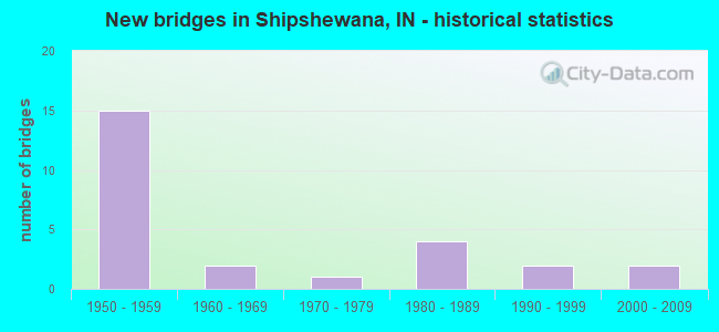
- New bridges - historical statistics
- 151950-1959
- 21960-1969
- 11970-1979
- 41980-1989
- 21990-1999
- 22000-2009

- Reconstructed bridges - Historical Statistics
- 51990-1999
- 12000-2009


- Bridge Condition - Deck
- 14.3%Very good
- 57.1%Good
- 14.3%Satisfactory
- 14.3%Fair

- Bridge Condition - Superstructure
- 57.1%Good
- 35.7%Satisfactory
- 7.1%Fair

- Bridge Condition - Substructure
- 7.1%Very good
- 64.3%Good
- 28.6%Satisfactory

- Bridge Condition - Channel
- 9.1%Very good
- 54.5%Good
- 36.4%Satisfactory
Find on map >> Show street view
Structure Number: 161, Location: 02.51 S US 20 (Lat: 41.618389, Lng: -85.579631), Route carried "on" structure: State highway 5, Year Built: 1988, Status: Open, Structure Length: 1.04m (3.41ft), Average Daily Traffic: 7,655 (year 2017), Truck Traffic: 21%, Average Future Daily Traffic: 10,542 (year 2034), Features Intersected: BONTRAGER DITCH
Minimum Vertical Clearance: 30+ m (98+ ft), Kilometerpoint: 10.445, Lanes on structure: 2, Owner: State Highway Agency, Approaching Roadway Width: 14.6m (47.9ft), Material/Design: Steel, Design/Construction: Culvert, Number Of Spans In Main Unit: 2, Length of Maximum Span: 4.5m (14.8ft), Curb-To-Curb Width: 14.6m (47.9ft), Out-to-Out Width: 14.6m (47.9ft)
Condition: Channel: Good, Culverts: Very good, Operating Rating: 48.3 metric tons, Method Used To Determine Operating Rating: Load and Resistance Factor Rating (LRFR) rating reported by rating factor(RF) method using HL-93 loadings, Inventory Rating: 37.3 metric tons, Method Used To Determine Inventory Rating: Load and Resistance Factor Rating (LRFR) rating reported by rating factor(RF) method using HL-93 loadings, Structural Evaluation: Equal to present desirable criteria, Deck Geometry: Superior to present desirable criteria, Waterway Adequacy: Equal to present desirable criteria, Approach Roadway Alignment: Equal to present desirable criteria, Designated Inspection Frequency: Every 24 months, Inspection Date: August 2020
Find on map >> Show street view
Structure Number: 4825, Location: 01.59 E SR 13 (Lat: 41.753239, Lng: -85.650558), Route carried "on" structure: County highway , Year Built: 1956, Year Reconstructed: 1997, Status: Open, Structure Length: 6.86m (22.51ft), Average Daily Traffic: 498 (year 2015), Truck Traffic: 10%, Average Future Daily Traffic: 2,766 (year 2031), Design Load: HS 20, Features Intersected: I-90, Facility Carried by Structure: CR 4/1150 W
Minimum Vertical Clearance: 30+ m (98+ ft), Kilometerpoint: 0.000, Lanes on structure: 2, Lanes under structure: 4, Owner: State Toll Authority, Approaching Roadway Width: 11.0m (36.1ft), Skew: 1 degrees, Material/Design: Steel, Design/Construction: Stringer/Multi-beam, Number Of Spans In Main Unit: 4, Length of Maximum Span: 20.9m (68.6ft), Curb-To-Curb Width: 7.9m (25.9ft), Out-to-Out Width: 9.1m (29.9ft)
Condition: Deck: Good, Superstructure: Satisfactory, Substructure: Satisfactory, Operating Rating: 85.0 metric tons, Method Used To Determine Operating Rating: Load Factor (LF), Inventory Rating: 50.9 metric tons, Method Used To Determine Inventory Rating: Load Factor (LF), Structural Evaluation: Equal to present minimum criteria, Deck Geometry: Somewhat better than minimum adequacy, Underclear: Meets minimum limits, Approach Roadway Alignment: Equal to present desirable criteria, Designated Inspection Frequency: Every 24 months, Other Special Inspection Frequency: Every 24 months, Inspection Date: August 2021, Other Special Inspection Date: August 2021, Deck Structure Type: Concrete Cast-file-Place, Wearing Surface/Protective System: Wearing Surface: Monolithic Concrete, Deck Protection: Epoxy Coated Reinforcing
Find on map >> Show street view
Structure Number: 4826, Location: 03.11 E SR 13 (Lat: 41.751419, Lng: -85.621733), Route carried "on" structure: Alternate County highway 1000, Year Built: 1956, Year Reconstructed: 1997, Status: Open, Structure Length: 6.58m (21.59ft), Average Daily Traffic: 260 (year 2015), Truck Traffic: 10%, Average Future Daily Traffic: 1,383 (year 2031), Design Load: HS 20, Features Intersected: I-90 EB/WB
Minimum Vertical Clearance: 30+ m (98+ ft), Kilometerpoint: 177.672, Lanes on structure: 2, Lanes under structure: 4, Owner: State Toll Authority, Approaching Roadway Width: 11.0m (36.1ft), Material/Design: Steel, Design/Construction: Stringer/Multi-beam, Number Of Spans In Main Unit: 4, Length of Maximum Span: 20.0m (65.6ft), Curb-To-Curb Width: 7.9m (25.9ft), Out-to-Out Width: 9.1m (29.9ft)
Condition: Deck: Very good, Superstructure: Satisfactory, Substructure: Good, Operating Rating: 87.1 metric tons, Method Used To Determine Operating Rating: Load Factor (LF), Inventory Rating: 52.1 metric tons, Method Used To Determine Inventory Rating: Load Factor (LF), Structural Evaluation: Equal to present minimum criteria, Deck Geometry: Somewhat better than minimum adequacy, Underclear: Meets minimum limits, Approach Roadway Alignment: Equal to present desirable criteria, Designated Inspection Frequency: Every 24 months, Other Special Inspection Frequency: Every 12 months, Inspection Date: July 2021, Other Special Inspection Date: July 2021, Deck Structure Type: Concrete Cast-file-Place, Wearing Surface/Protective System: Wearing Surface: Monolithic Concrete
Find on map >> Show street view
Structure Number: 4827, Location: 04.12 E SR 13 (Lat: 41.752189, Lng: -85.602142), Route carried "on" structure: Alternate County highway , Year Built: 1956, Year Reconstructed: 1997, Status: Open, Structure Length: 6.64m (21.78ft), Average Daily Traffic: 262 (year 2015), Truck Traffic: 10%, Average Future Daily Traffic: 504 (year 2031), Design Load: HS 20, Features Intersected: I-90 EB/WB, Facility Carried by Structure: CR 900 W/SNYDER RD
Minimum Vertical Clearance: 30+ m (98+ ft), Kilometerpoint: 179.281, Lanes on structure: 2, Lanes under structure: 4, Owner: State Toll Authority, Approaching Roadway Width: 11.6m (38.1ft), Material/Design: Steel, Design/Construction: Stringer/Multi-beam, Number Of Spans In Main Unit: 4, Length of Maximum Span: 20.0m (65.6ft), Curb-To-Curb Width: 8.2m (26.9ft), Out-to-Out Width: 9.1m (29.9ft)
Condition: Deck: Good, Superstructure: Good, Substructure: Good, Operating Rating: 87.2 metric tons, Method Used To Determine Operating Rating: Load Factor (LF), Inventory Rating: 52.2 metric tons, Method Used To Determine Inventory Rating: Load Factor (LF), Structural Evaluation: Better than present minimum criteria, Deck Geometry: Somewhat better than minimum adequacy, Underclear: Meets minimum limits, Approach Roadway Alignment: Equal to present desirable criteria, Designated Inspection Frequency: Every 24 months, Other Special Inspection Frequency: Every 24 months, Inspection Date: August 2021, Other Special Inspection Date: August 2021, Deck Structure Type: Concrete Cast-file-Place, Wearing Surface/Protective System: Wearing Surface: Monolithic Concrete
Find on map >> Show street view
Structure Number: 4828, Location: 05.10 E SR 13 (Lat: 41.753369, Lng: -85.583244), Route carried "on" structure: County highway , Year Built: 1956, Year Reconstructed: 1997, Status: Open, Structure Length: 6.61m (21.69ft), Average Daily Traffic: 224 (year 2015), Truck Traffic: 10%, Average Future Daily Traffic: 366 (year 2031), Design Load: HS 20, Features Intersected: I-90 EB/WB, Facility Carried by Structure: CR 800 W/FERGUSON
Minimum Vertical Clearance: 30+ m (98+ ft), Kilometerpoint: 180.890, Lanes on structure: 2, Lanes under structure: 4, Owner: State Toll Authority, Approaching Roadway Width: 11.6m (38.1ft), Material/Design: Steel, Design/Construction: Stringer/Multi-beam, Number Of Spans In Main Unit: 4, Length of Maximum Span: 20.3m (66.6ft), Curb-To-Curb Width: 8.2m (26.9ft), Out-to-Out Width: 9.1m (29.9ft)
Condition: Deck: Good, Superstructure: Satisfactory, Substructure: Good, Operating Rating: 84.9 metric tons, Method Used To Determine Operating Rating: Load Factor (LF), Inventory Rating: 50.8 metric tons, Method Used To Determine Inventory Rating: Load Factor (LF), Structural Evaluation: Equal to present minimum criteria, Deck Geometry: Somewhat better than minimum adequacy, Underclear: Somewhat better than minimum adequacy, Approach Roadway Alignment: Equal to present desirable criteria, Designated Inspection Frequency: Every 24 months, Other Special Inspection Frequency: Every 24 months, Inspection Date: August 2021, Other Special Inspection Date: August 2021, Deck Structure Type: Concrete Cast-file-Place, Wearing Surface/Protective System: Wearing Surface: Monolithic Concrete
Find on map >> Show street view
Structure Number: 4832, Location: 06.12 W SR 9 (Lat: 41.746269, Lng: -85.543419), Route carried "on" structure: Alternate County highway , Year Built: 1956, Year Reconstructed: 2000, Status: Open, Structure Length: 6.61m (21.69ft), Average Daily Traffic: 507 (year 2015), Truck Traffic: 10%, Average Future Daily Traffic: 1,538 (year 2031), Design Load: HS 20, Features Intersected: I-90, Facility Carried by Structure: CR 600 W/OLNEY RD
Minimum Vertical Clearance: 30+ m (98+ ft), Kilometerpoint: 184.270, Lanes on structure: 2, Lanes under structure: 4, Owner: State Toll Authority, Approaching Roadway Width: 9.5m (31.2ft), Skew: 1 degrees, Material/Design: Steel, Design/Construction: Stringer/Multi-beam, Number Of Spans In Main Unit: 4, Length of Maximum Span: 20.3m (66.6ft), Curb-To-Curb Width: 8.2m (26.9ft), Out-to-Out Width: 9.1m (29.9ft)
Condition: Deck: Very good, Superstructure: Good, Substructure: Good, Operating Rating: 87.0 metric tons, Method Used To Determine Operating Rating: Load Factor (LF), Inventory Rating: 52.0 metric tons, Method Used To Determine Inventory Rating: Load Factor (LF), Structural Evaluation: Better than present minimum criteria, Deck Geometry: Somewhat better than minimum adequacy, Underclear: Somewhat better than minimum adequacy, Approach Roadway Alignment: Equal to present minimum criteria, Designated Inspection Frequency: Every 24 months, Other Special Inspection Frequency: Every 24 months, Inspection Date: August 2021, Other Special Inspection Date: August 2021, Deck Structure Type: Concrete Cast-file-Place, Wearing Surface/Protective System: Wearing Surface: Monolithic Concrete, Deck Protection: Epoxy Coated Reinforcing
Find on map >> Show street view
Structure Number: 80384, Location: 00.49 E SR 5 (Lat: 41.726969, Lng: -85.572500), Route carried "on" structure: State highway 120, Year Built: 2008, Status: Open, Structure Length: 0.76m (2.49ft), Average Daily Traffic: 4,373 (year 2019), Truck Traffic: 16%, Average Future Daily Traffic: 6,860 (year 2034), Design Load: HL 93, Features Intersected: PAGE DITCH
Minimum Vertical Clearance: 30+ m (98+ ft), Kilometerpoint: 15.578, Lanes on structure: 2, Owner: State Highway Agency, Approaching Roadway Width: 11.0m (36.1ft), Skew: 4 degrees, Material/Design: Concrete, Design/Construction: Culvert, Number Of Spans In Main Unit: 1, Length of Maximum Span: 7.6m (24.9ft), Curb-To-Curb Width: 11.0m (36.1ft), Out-to-Out Width: 14.6m (47.9ft)
Condition: Channel: Very good, Culverts: Very good, Operating Rating: 82.0 metric tons, Method Used To Determine Operating Rating: Load and Resistance Factor Rating (LRFR) rating reported by rating factor(RF) method using HL-93 loadings, Inventory Rating: 63.5 metric tons, Method Used To Determine Inventory Rating: Load and Resistance Factor Rating (LRFR) rating reported by rating factor(RF) method using HL-93 loadings, Structural Evaluation: Equal to present desirable criteria, Deck Geometry: Somewhat better than minimum adequacy, Waterway Adequacy: Equal to present desirable criteria, Approach Roadway Alignment: Equal to present desirable criteria, Designated Inspection Frequency: Every 24 months, Inspection Date: May 2020
Find on map >> Show street view
Structure Number: 4400004, Location: 00.15 E OF CR 1000W (Lat: 41.625350, Lng: -85.616011), Route carried "on" structure: County highway 32, Year Built: 1982, Status: Posted for load, Structure Length: 1.13m (3.71ft), Average Daily Traffic: 100 (year 2019), Truck Traffic: 3%, Average Future Daily Traffic: 150 (year 2039), Design Load: HS 20, Features Intersected: LITTLE ELKHART RIVER, Facility Carried by Structure: CR 100 SOUTH
Minimum Vertical Clearance: 30+ m (98+ ft), Kilometerpoint: 0.000, Lanes on structure: 2, Owner: County Highway Agency, Approaching Roadway Width: 5.5m (18.0ft), Skew: 4 degrees, Material/Design: Prestressed concrete, Design/Construction: Box Beam or Girders - Multiple, Number Of Spans In Main Unit: 1, Length of Maximum Span: 10.0m (32.8ft), Curb-To-Curb Width: 7.2m (23.6ft), Out-to-Out Width: 7.3m (24.0ft)
Condition: Deck: Good, Superstructure: Good, Substructure: Satisfactory, Channel: Satisfactory, Operating Rating: 45.1 metric tons, Method Used To Determine Operating Rating: Load Factor (LF), Inventory Rating: 27.0 metric tons, Method Used To Determine Inventory Rating: Load Factor (LF), Structural Evaluation: Equal to present minimum criteria, Deck Geometry: Somewhat better than minimum adequacy, Waterway Adequacy: Better than present minimum criteria, Approach Roadway Alignment: Equal to present desirable criteria, Designated Inspection Frequency: Every 24 months, Inspection Date: November 2021, Deck Structure Type: Concrete Precast Panels, Wearing Surface/Protective System: Wearing Surface: Bituminous
Find on map >> Show street view
Structure Number: 4400009, Location: 00.20 N OF CR 100S (Lat: 41.627639, Lng: -85.618681), Route carried "on" structure: County highway 5, Year Built: 1977, Status: Posted for load, Structure Length: 1.28m (4.20ft), Average Daily Traffic: 625 (year 2019), Truck Traffic: 3%, Average Future Daily Traffic: 975 (year 2039), Design Load: HS 20, Features Intersected: LITTLE ELKHART RIVER, Facility Carried by Structure: CR 1000 WEST
Minimum Vertical Clearance: 30+ m (98+ ft), Kilometerpoint: 0.000, Lanes on structure: 2, Owner: County Highway Agency, Approaching Roadway Width: 6.7m (22.0ft), Skew: 1 degrees, Material/Design: Prestressed concrete, Design/Construction: Box Beam or Girders - Multiple, Number Of Spans In Main Unit: 1, Length of Maximum Span: 11.9m (39.0ft), Curb-To-Curb Width: 7.2m (23.6ft), Out-to-Out Width: 7.3m (24.0ft)
Condition: Deck: Good, Superstructure: Good, Substructure: Good, Channel: Good, Operating Rating: 36.9 metric tons, Method Used To Determine Operating Rating: Load Factor (LF), Inventory Rating: 22.1 metric tons, Method Used To Determine Inventory Rating: Load Factor (LF), Structural Evaluation: Somewhat better than minimum adequacy, Deck Geometry: Meets minimum limits, Waterway Adequacy: Better than present minimum criteria, Approach Roadway Alignment: Equal to present desirable criteria, Designated Inspection Frequency: Every 24 months, Inspection Date: November 2021, Deck Structure Type: Concrete Precast Panels, Wearing Surface/Protective System: Wearing Surface: Bituminous
Find on map >> Show street view
Structure Number: 4400012, Location: 00.30 E OF CR 800 W (Lat: 41.748800, Lng: -85.576519), Route carried "on" structure: County highway 60, Year Built: 1985, Status: Open, Structure Length: 4.65m (15.26ft), Average Daily Traffic: 375 (year 2021), Truck Traffic: 5%, Average Future Daily Traffic: 575 (year 2041), Design Load: HS 20, Features Intersected: PIGEON RIVER, Facility Carried by Structure: CR 750 NORTH
Minimum Vertical Clearance: 30+ m (98+ ft), Kilometerpoint: 0.000, Lanes on structure: 2, Owner: County Highway Agency, Approaching Roadway Width: 6.7m (22.0ft), Skew: 4 degrees, Material/Design: Prestressed concrete continuous, Design/Construction: Box Beam or Girders - Single/Spread, Number Of Spans In Main Unit: 3, Length of Maximum Span: 16.2m (53.1ft), Curb-To-Curb Width: 8.6m (28.2ft), Out-to-Out Width: 9.3m (30.5ft)
Condition: Deck: Satisfactory, Superstructure: Good, Substructure: Good, Channel: Satisfactory, Operating Rating: 74.6 metric tons, Method Used To Determine Operating Rating: Load Factor (LF), Inventory Rating: 30.1 metric tons, Method Used To Determine Inventory Rating: Load Factor (LF), Structural Evaluation: Better than present minimum criteria, Deck Geometry: Equal to present minimum criteria, Waterway Adequacy: Better than present minimum criteria, Approach Roadway Alignment: Equal to present desirable criteria, Designated Inspection Frequency: Every 24 months, Inspection Date: November 2021, Deck Structure Type: Concrete Cast-file-Place, Wearing Surface/Protective System: Wearing Surface: Monolithic Concrete
Find on map >> Show street view
Structure Number: 4400016, Location: 00.40 N OF CR 600 N (Lat: 41.731950, Lng: -85.534081), Route carried "on" structure: County highway 141, Year Built: 1992, Status: Posted for load, Structure Length: 3.47m (11.38ft), Average Daily Traffic: 100 (year 2021), Truck Traffic: 3%, Average Future Daily Traffic: 150 (year 2041), Design Load: HS 20, Features Intersected: PIGEON RIVER, Facility Carried by Structure: CR 550 WEST
Minimum Vertical Clearance: 30+ m (98+ ft), Kilometerpoint: 0.000, Lanes on structure: 2, Owner: County Highway Agency, Approaching Roadway Width: 5.5m (18.0ft), Skew: 2 degrees, Material/Design: Wood or Timber, Design/Construction: Slab, Number Of Spans In Main Unit: 5, Length of Maximum Span: 7.9m (25.9ft), Curb or Sidewalk Widths: Left: 0.2m (0.7ft), Right: 0.2m (0.7ft), Curb-To-Curb Width: 7.5m (24.6ft), Out-to-Out Width: 7.9m (25.9ft)
Condition: Deck: Good, Superstructure: Good, Substructure: Good, Channel: Good, Operating Rating: 38.5 metric tons, Method Used To Determine Operating Rating: Load and Resistance Factor (LRFR), Inventory Rating: 29.7 metric tons, Method Used To Determine Inventory Rating: Load and Resistance Factor (LRFR), Structural Evaluation: Better than present minimum criteria, Deck Geometry: Equal to present minimum criteria, Waterway Adequacy: Better than present minimum criteria, Approach Roadway Alignment: Equal to present minimum criteria, Designated Inspection Frequency: Every 24 months, Underwater Inspection Frequency: Every 60 months, Inspection Date: November 2021, Underwater Inspection Date: November 2017, Deck Structure Type: Wood or Timber, Wearing Surface/Protective System: Wearing Surface: Bituminous, Deck Protection: Internally Sealed
Find on map >> Show street view
Structure Number: 4400056, Location: 00.25 N OF CR 650 N (Lat: 41.737789, Lng: -85.557961), Route carried "on" structure: County highway 377, Year Built: 1960, Status: Open, Structure Length: 1.90m (6.23ft), Average Daily Traffic: 1,000 (year 2021), Truck Traffic: 6%, Average Future Daily Traffic: 1,525 (year 2041), Design Load: HS 20, Features Intersected: PIGEON RIVER, Facility Carried by Structure: CR 675 WEST
Minimum Vertical Clearance: 30+ m (98+ ft), Kilometerpoint: 0.000, Lanes on structure: 2, Owner: County Highway Agency, Approaching Roadway Width: 7.3m (24.0ft), Material/Design: Concrete continuous, Design/Construction: Slab, Number Of Spans In Main Unit: 3, Length of Maximum Span: 6.6m (21.7ft), Curb-To-Curb Width: 12.1m (39.7ft), Out-to-Out Width: 12.9m (42.3ft)
Condition: Deck: Satisfactory, Superstructure: Satisfactory, Substructure: Satisfactory, Channel: Satisfactory, Operating Rating: 32.7 metric tons, Method Used To Determine Operating Rating: Field evaluation and documented engineering judgment, Inventory Rating: 32.7 metric tons, Method Used To Determine Inventory Rating: Field evaluation and documented engineering judgment, Structural Evaluation: Equal to present minimum criteria, Deck Geometry: Better than present minimum criteria, Waterway Adequacy: Better than present minimum criteria, Approach Roadway Alignment: Equal to present minimum criteria, Designated Inspection Frequency: Every 24 months, Inspection Date: November 2021, Deck Structure Type: Concrete Cast-file-Place, Wearing Surface/Protective System: Wearing Surface: Latex Concrete
Find on map >> Show street view
Structure Number: 4400057, Location: 00.04 S OF CR 690 N (Lat: 41.740081, Lng: -85.557069), Route carried "on" structure: County highway 377, Year Built: 1960, Year Reconstructed: 1997, Status: Open, Structure Length: 5.82m (19.09ft), Average Daily Traffic: 1,000 (year 2021), Truck Traffic: 6%, Average Future Daily Traffic: 1,525 (year 2041), Design Load: HS 20, Features Intersected: PIGEON RIVER, Facility Carried by Structure: CR 675 WEST
Minimum Vertical Clearance: 30+ m (98+ ft), Kilometerpoint: 0.000, Lanes on structure: 2, Owner: County Highway Agency, Approaching Roadway Width: 7.3m (24.0ft), Skew: 1 degrees, Material/Design: Concrete continuous, Design/Construction: Stringer/Multi-beam, Number Of Spans In Main Unit: 3, Length of Maximum Span: 22.9m (75.1ft), Curb or Sidewalk Widths: Left: 0.5m (1.6ft), Right: 0.5m (1.6ft), Curb-To-Curb Width: 8.6m (28.2ft), Out-to-Out Width: 10.5m (34.4ft)
Condition: Deck: Fair, Superstructure: Satisfactory, Substructure: Satisfactory, Channel: Satisfactory, Operating Rating: 32.7 metric tons, Method Used To Determine Operating Rating: Field evaluation and documented engineering judgment, Inventory Rating: 32.7 metric tons, Method Used To Determine Inventory Rating: Field evaluation and documented engineering judgment, Structural Evaluation: Equal to present minimum criteria, Deck Geometry: Somewhat better than minimum adequacy, Waterway Adequacy: Better than present minimum criteria, Approach Roadway Alignment: Equal to present minimum criteria, Designated Inspection Frequency: Every 24 months, Inspection Date: November 2021, Deck Structure Type: Concrete Cast-file-Place, Wearing Surface/Protective System: Wearing Surface: Bituminous
Find on map >> Show street view
Structure Number: 4400061, Location: 00.10 E OF CR 900W (Lat: 41.611031, Lng: -85.596950), Route carried "on" structure: County highway 28, Year Built: 1984, Status: Posted for load, Structure Length: 0.91m (2.99ft), Average Daily Traffic: 1,525 (year 2019), Truck Traffic: 12%, Average Future Daily Traffic: 2,000 (year 2039), Design Load: HS 20, Features Intersected: LITTLE ELKHART RIVER, Facility Carried by Structure: CR 200 SOUTH
Minimum Vertical Clearance: 30+ m (98+ ft), Kilometerpoint: 0.000, Lanes on structure: 2, Owner: County Highway Agency, Approaching Roadway Width: 7.3m (24.0ft), Skew: 2 degrees, Material/Design: Wood or Timber, Design/Construction: Slab, Number Of Spans In Main Unit: 1, Length of Maximum Span: 8.8m (28.9ft), Curb or Sidewalk Widths: Left: 0.2m (0.7ft), Right: 0.2m (0.7ft), Curb-To-Curb Width: 7.4m (24.3ft), Out-to-Out Width: 7.8m (25.6ft)
Condition: Deck: Fair, Superstructure: Fair, Substructure: Good, Channel: Good, Operating Rating: 34.3 metric tons, Method Used To Determine Operating Rating: Load and Resistance Factor (LRFR), Inventory Rating: 26.4 metric tons, Method Used To Determine Inventory Rating: Load and Resistance Factor (LRFR), Structural Evaluation: Somewhat better than minimum adequacy, Deck Geometry: Meets minimum limits, Waterway Adequacy: Better than present minimum criteria, Approach Roadway Alignment: Equal to present desirable criteria, Designated Inspection Frequency: Every 24 months, Inspection Date: November 2021, Deck Structure Type: Wood or Timber, Wearing Surface/Protective System: Wearing Surface: Bituminous, Deck Protection: Internally Sealed
Find on map >> Show street view
Structure Number: 4400063, Location: 00.15 W OF CR 600W (Lat: 41.611419, Lng: -85.543911), Route carried "on" structure: County highway 28, Year Built: 1998, Status: Open, Structure Length: 0.67m (2.20ft), Average Daily Traffic: 1,750 (year 2019), Truck Traffic: 6%, Average Future Daily Traffic: 2,675 (year 2039), Design Load: HS 20, Features Intersected: EMMA CREEK, Facility Carried by Structure: CR 200 SOUTH
Minimum Vertical Clearance: 30+ m (98+ ft), Kilometerpoint: 0.000, Lanes on structure: 2, Owner: County Highway Agency, Approaching Roadway Width: 8.5m (27.9ft), Material/Design: Prestressed concrete, Design/Construction: Box Beam or Girders - Multiple, Number Of Spans In Main Unit: 1, Length of Maximum Span: 6.4m (21.0ft), Curb-To-Curb Width: 9.6m (31.5ft), Out-to-Out Width: 9.8m (32.2ft)
Condition: Deck: Good, Superstructure: Good, Substructure: Good, Channel: Good, Operating Rating: 71.6 metric tons, Method Used To Determine Operating Rating: Load Factor (LF), Inventory Rating: 42.9 metric tons, Method Used To Determine Inventory Rating: Load Factor (LF), Structural Evaluation: Better than present minimum criteria, Deck Geometry: Somewhat better than minimum adequacy, Waterway Adequacy: Equal to present minimum criteria, Approach Roadway Alignment: Equal to present desirable criteria, Designated Inspection Frequency: Every 24 months, Inspection Date: November 2021, Deck Structure Type: Concrete Precast Panels, Wearing Surface/Protective System: Wearing Surface: Bituminous
Find on map >> Show street view
Structure Number: 4400112, Location: 00.02 N OF CR 270N (Lat: 41.679261, Lng: -85.602589), Route carried "on" structure: County highway 182, Year Built: 2007, Status: Posted for load, Structure Length: 0.91m (2.99ft), Average Daily Traffic: 75 (year 2021), Truck Traffic: 2%, Average Future Daily Traffic: 100 (year 2041), Design Load: HS 20, Features Intersected: BRANCH LAKE SHIPSHEWANA, Facility Carried by Structure: CR 915 WEST
Minimum Vertical Clearance: 30+ m (98+ ft), Kilometerpoint: 0.000, Lanes on structure: 2, Owner: County Highway Agency, Approaching Roadway Width: 3.0m (9.8ft), Material/Design: Wood or Timber, Design/Construction: Slab, Number Of Spans In Main Unit: 1, Length of Maximum Span: 8.8m (28.9ft), Curb or Sidewalk Widths: Left: 0.2m (0.7ft), Right: 0.2m (0.7ft), Curb-To-Curb Width: 5.0m (16.4ft), Out-to-Out Width: 5.4m (17.7ft)
Condition: Deck: Good, Superstructure: Good, Substructure: Very good, Channel: Good, Operating Rating: 46.0 metric tons, Method Used To Determine Operating Rating: Load and Resistance Factor (LRFR), Inventory Rating: 35.6 metric tons, Method Used To Determine Inventory Rating: Load and Resistance Factor (LRFR), Structural Evaluation: Better than present minimum criteria, Deck Geometry: High priority of corrective action, Waterway Adequacy: Better than present minimum criteria, Approach Roadway Alignment: Equal to present desirable criteria, Designated Inspection Frequency: Every 24 months, Inspection Date: November 2021, Deck Structure Type: Wood or Timber, Wearing Surface/Protective System: Wearing Surface: Bituminous, Deck Protection: Internally Sealed
Find on map >> Show street view
Structure Number: 4825, Location: 01.59 E SR 13 (Lat: 41.753239, Lng: -85.650558), Route carried "under" structure: Interstate 90, Year Built: 1956, Structure Length: 0. m, Average Daily Traffic: 11,575 (year 2015), Truck Traffic: 10%, Features Intersected: I-90 EB, Facility Carried by Structure: CR 4/1150W
Minimum Vertical Clearance: 4.78m (15.68ft), Kilometerpoint: 175.258, Lanes on structure: 2, Lanes under structure: 2, Toll: On toll road, Material/Design: Steel, Design/Construction: Stringer/Multi-beam, Length of Maximum Span: 20.9m (68.6ft)
Find on map >> Show street view
Structure Number: 4825, Location: 01.59 E SR 13 (Lat: 41.753239, Lng: -85.650558), Route carried "under" structure: Interstate 90, Year Built: 1956, Structure Length: 0. m, Average Daily Traffic: 11,575 (year 2015), Truck Traffic: 10%, Features Intersected: I-90 WB, Facility Carried by Structure: CR 4/1150W
Minimum Vertical Clearance: 4.78m (15.68ft), Kilometerpoint: 175.258, Lanes on structure: 2, Lanes under structure: 2, Toll: On toll road, Material/Design: Steel, Design/Construction: Stringer/Multi-beam, Length of Maximum Span: 20.9m (68.6ft)
Find on map >> Show street view
Structure Number: 4826, Location: 03.11 E SR 13 (Lat: 41.751381, Lng: -85.621764), Route carried "under" structure: Interstate 90, Year Built: 1956, Structure Length: 0. m, Average Daily Traffic: 11,575 (year 2015), Truck Traffic: 10%, Features Intersected: I-90 EB, Facility Carried by Structure: CR 1000W
Minimum Vertical Clearance: 4.78m (15.68ft), Kilometerpoint: 177.704, Lanes on structure: 2, Lanes under structure: 2, Toll: On toll road, Material/Design: Steel, Design/Construction: Stringer/Multi-beam, Length of Maximum Span: 20.0m (65.6ft)
Find on map >> Show street view
Structure Number: 4826, Location: 03.11 E SR 13 (Lat: 41.751381, Lng: -85.621764), Route carried "under" structure: Interstate 90, Year Built: 1956, Structure Length: 0. m, Average Daily Traffic: 11,575 (year 2015), Truck Traffic: 10%, Features Intersected: I-90 WB, Facility Carried by Structure: CR 1000W
Minimum Vertical Clearance: 4.78m (15.68ft), Kilometerpoint: 177.704, Lanes on structure: 2, Lanes under structure: 2, Toll: On toll road, Material/Design: Steel, Design/Construction: Stringer/Multi-beam, Length of Maximum Span: 20.0m (65.6ft)
Find on map >> Show street view
Structure Number: 4827, Location: 04.12 E SR 13 (Lat: 41.752189, Lng: -85.602142), Route carried "under" structure: Interstate 90, Year Built: 1956, Structure Length: 0. m, Average Daily Traffic: 11,575 (year 2015), Truck Traffic: 10%, Features Intersected: I-90 EB
Minimum Vertical Clearance: 4.80m (15.75ft), Kilometerpoint: 179.329, Lanes on structure: 2, Lanes under structure: 2, Toll: On toll road, Material/Design: Steel, Design/Construction: Stringer/Multi-beam, Length of Maximum Span: 20.0m (65.6ft)
Find on map >> Show street view
Structure Number: 4827, Location: 04.12 E SR 13 (Lat: 41.752189, Lng: -85.602142), Route carried "under" structure: Interstate 90, Year Built: 1956, Structure Length: 0. m, Average Daily Traffic: 11,575 (year 2015), Truck Traffic: 10%, Features Intersected: I-90 WB
Minimum Vertical Clearance: 4.80m (15.75ft), Kilometerpoint: 179.329, Lanes on structure: 2, Lanes under structure: 2, Toll: On toll road, Material/Design: Steel, Design/Construction: Stringer/Multi-beam, Length of Maximum Span: 20.0m (65.6ft)
Find on map >> Show street view
Structure Number: 4828, Location: 05.10 E SR 13 (Lat: 41.753369, Lng: -85.583244), Route carried "under" structure: Interstate 90, Year Built: 1956, Structure Length: 0. m, Average Daily Traffic: 11,575 (year 2015), Truck Traffic: 10%, Features Intersected: I-90 WB, Facility Carried by Structure: CR 800W/FERGUSON
Minimum Vertical Clearance: 4.83m (15.85ft), Kilometerpoint: 180.906, Lanes on structure: 2, Lanes under structure: 2, Toll: On toll road, Material/Design: Steel, Design/Construction: Stringer/Multi-beam, Length of Maximum Span: 20.3m (66.6ft)
Find on map >> Show street view
Structure Number: 4828, Location: 05.10 E SR 13 (Lat: 41.753369, Lng: -85.583244), Route carried "under" structure: Interstate 90, Year Built: 1956, Structure Length: 0. m, Average Daily Traffic: 11,575 (year 2015), Truck Traffic: 10%, Features Intersected: I-90 EB, Facility Carried by Structure: CR 800W/FERGUSON
Minimum Vertical Clearance: 4.83m (15.85ft), Kilometerpoint: 180.906, Lanes on structure: 2, Lanes under structure: 2, Toll: On toll road, Material/Design: Steel, Design/Construction: Stringer/Multi-beam, Length of Maximum Span: 20.3m (66.6ft)
Find on map >> Show street view
Structure Number: 4832, Location: 06.12 W SR 9 (Lat: 41.746269, Lng: -85.543419), Route carried "under" structure: Interstate 90, Year Built: 1956, Structure Length: 0. m, Average Daily Traffic: 11,575 (year 2015), Truck Traffic: 10%, Features Intersected: I-90 EB, Facility Carried by Structure: CR 600W/OLNEY RD
Minimum Vertical Clearance: 4.83m (15.85ft), Kilometerpoint: 184.350, Lanes on structure: 2, Lanes under structure: 2, Toll: On toll road, Material/Design: Steel, Design/Construction: Stringer/Multi-beam, Length of Maximum Span: 20.3m (66.6ft)
Find on map >> Show street view
Structure Number: 4832, Location: 06.12 W SR 9 (Lat: 41.746269, Lng: -85.543419), Route carried "under" structure: Interstate 90, Year Built: 1956, Structure Length: 0. m, Average Daily Traffic: 11,575 (year 2015), Truck Traffic: 10%, Features Intersected: I-90 WB, Facility Carried by Structure: CR 600W/OLNEY RD
Minimum Vertical Clearance: 4.83m (15.85ft), Kilometerpoint: 184.350, Lanes on structure: 2, Lanes under structure: 2, Toll: On toll road, Material/Design: Steel, Design/Construction: Stringer/Multi-beam, Length of Maximum Span: 20.3m (66.6ft)