Bridge Statistics for Shively, Kentucky (KY)
Condition, Traffic, Stress, Structural Evaluation, Project Costs
- National Bridge Inventory (NBI) Statistics
- 34Number of bridges
- 226ft / 69.3mTotal length
- $9,259,000Total costs
- 1,399,173Total average daily traffic
- 62,625Total average daily truck traffic
- National Bridge Inventory (NBI) Registered Bridges for Shively
- No street view available for this location
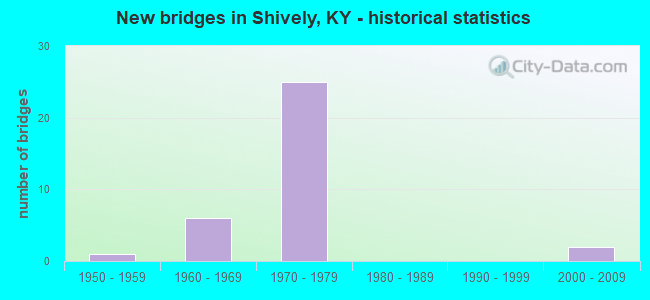
- New bridges - historical statistics
- 11950-1959
- 61960-1969
- 251970-1979
- 22000-2009


- Bridge Condition - Deck
- 6.7%Good
- 53.3%Satisfactory
- 33.3%Fair
- 6.7%Poor

- Bridge Condition - Superstructure
- 13.3%Good
- 86.7%Satisfactory

- Bridge Condition - Substructure
- 73.3%Satisfactory
- 20.0%Fair
- 6.7%Poor

- Bridge Condition - Channel
- 12.5%Very good
- 50.0%Good
- 25.0%Satisfactory
- 12.5%Fair
Find on map >> Show street view
Structure Number: 56B00228N, Location: 0.8 MI W OF US 31W NTRCH (Lat: 38.186389, Lng: -85.826667), Route carried "on" structure: Interstate 264, Year Built: 1971, Year Reconstructed: 2003, Status: Open, Structure Length: 4.89m (16.04ft), Average Daily Traffic: 54,708 (year 2020), Truck Traffic: 10%, Average Future Daily Traffic: 58,537 (year 2040), Design Load: HS 20, Features Intersected: SAVAGE DR
Minimum Vertical Clearance: 30+ m (98+ ft), Kilometerpoint: 10.824, Lanes on structure: 6, Lanes under structure: 2, Base Highway Network: Yes, Owner: State Highway Agency, Approaching Roadway Width: 32.7m (107.3ft), Skew: 32 degrees, Material/Design: Concrete continuous, Design/Construction: Tee Beam, Number Of Spans In Main Unit: 3, Length of Maximum Span: 18.7m (61.4ft), Curb-To-Curb Width: 32.7m (107.3ft), Out-to-Out Width: 34.4m (112.9ft)
Condition: Deck: Fair, Superstructure: Satisfactory, Substructure: Satisfactory, Operating Rating: 69.3 metric tons, Method Used To Determine Operating Rating: Load Factor (LF), Inventory Rating: 41.6 metric tons, Method Used To Determine Inventory Rating: Load Factor (LF), Structural Evaluation: Equal to present minimum criteria, Deck Geometry: Superior to present desirable criteria, Underclear: Better than present minimum criteria, Approach Roadway Alignment: Equal to present desirable criteria, Designated Inspection Frequency: Every 24 months, Inspection Date: January 2021, Deck Structure Type: Concrete Cast-file-Place, Wearing Surface/Protective System: Wearing Surface: Monolithic Concrete, Deck Protection: Epoxy Coated Reinforcing
Find on map >> Show street view
Structure Number: 56B00229N, Location: 1.1 MI W OF US 31W NTRCH (Lat: 38.190278, Lng: -85.830278), Route carried "on" structure: Interstate 264, Year Built: 1971, Year Reconstructed: 2003, Status: Open, Structure Length: 4.77m (15.65ft), Average Daily Traffic: 54,708 (year 2020), Truck Traffic: 10%, Average Future Daily Traffic: 58,537 (year 2040), Design Load: HS 20, Features Intersected: GARRS LN
Minimum Vertical Clearance: 30+ m (98+ ft), Kilometerpoint: 10.255, Lanes on structure: 6, Lanes under structure: 2, Base Highway Network: Yes, Owner: State Highway Agency, Approaching Roadway Width: 32.3m (106.0ft), Skew: 31 degrees, Material/Design: Concrete continuous, Design/Construction: Tee Beam, Number Of Spans In Main Unit: 3, Length of Maximum Span: 19.6m (64.3ft), Curb-To-Curb Width: 32.3m (106.0ft), Out-to-Out Width: 34.0m (111.5ft)
Condition: Deck: Fair, Superstructure: Satisfactory, Substructure: Fair, Operating Rating: 79.8 metric tons, Method Used To Determine Operating Rating: Load Factor (LF), Inventory Rating: 47.9 metric tons, Method Used To Determine Inventory Rating: Load Factor (LF), Structural Evaluation: Somewhat better than minimum adequacy, Deck Geometry: Superior to present desirable criteria, Underclear: Better than present minimum criteria, Approach Roadway Alignment: Equal to present desirable criteria, Designated Inspection Frequency: Every 24 months, Inspection Date: January 2021, Deck Structure Type: Concrete Cast-file-Place, Wearing Surface/Protective System: Wearing Surface: Monolithic Concrete, Deck Protection: Epoxy Coated Reinforcing
Find on map >> Show street view
Structure Number: 56B00230N, Location: 0.75 MI E OF KY 1934 NTRC (Lat: 38.195833, Lng: -85.828889), Route carried "on" structure: Interstate 264, Year Built: 1971, Year Reconstructed: 2003, Status: Open, Structure Length: 4.68m (15.35ft), Average Daily Traffic: 54,708 (year 2020), Truck Traffic: 10%, Average Future Daily Traffic: 58,537 (year 2040), Design Load: HS 20, Features Intersected: CRUMS LN
Minimum Vertical Clearance: 30+ m (98+ ft), Kilometerpoint: 9.622, Lanes on structure: 6, Lanes under structure: 4, Base Highway Network: Yes, Owner: State Highway Agency, Approaching Roadway Width: 32.3m (106.0ft), Skew: 30 degrees, Material/Design: Concrete continuous, Design/Construction: Tee Beam, Number Of Spans In Main Unit: 3, Length of Maximum Span: 20.7m (67.9ft), Curb-To-Curb Width: 32.3m (106.0ft), Out-to-Out Width: 34.0m (111.5ft)
Condition: Deck: Fair, Superstructure: Satisfactory, Substructure: Satisfactory, Operating Rating: 68.4 metric tons, Method Used To Determine Operating Rating: Load Factor (LF), Inventory Rating: 41.1 metric tons, Method Used To Determine Inventory Rating: Load Factor (LF), Structural Evaluation: Equal to present minimum criteria, Deck Geometry: Superior to present desirable criteria, Underclear: Meets minimum limits, Approach Roadway Alignment: Equal to present desirable criteria, Length Of Structure Improvement: 0.46m (1.51ft), Designated Inspection Frequency: Every 24 months, Inspection Date: January 2021, Bridge Improvement Cost: $2,084,000, Total Project Cost: $2,084,000, Deck Structure Type: Concrete Cast-file-Place, Wearing Surface/Protective System: Wearing Surface: Monolithic Concrete, Deck Protection: Epoxy Coated Reinforcing
Find on map >> Show street view
Structure Number: 56B00231N, Location: 0.25 MI E OF KY 1934 NTRC (Lat: 38.203056, Lng: -85.827500), Route carried "on" structure: Interstate 264, Year Built: 1971, Year Reconstructed: 2003, Status: Open, Structure Length: 4.37m (14.34ft), Average Daily Traffic: 54,708 (year 2020), Truck Traffic: 10%, Average Future Daily Traffic: 58,537 (year 2040), Design Load: HS 20, Features Intersected: FARNSLEY RD
Minimum Vertical Clearance: 30+ m (98+ ft), Kilometerpoint: 8.798, Lanes on structure: 6, Lanes under structure: 2, Base Highway Network: Yes, Owner: State Highway Agency, Approaching Roadway Width: 36.6m (120.1ft), Skew: 30 degrees, Material/Design: Concrete continuous, Design/Construction: Tee Beam, Number Of Spans In Main Unit: 3, Length of Maximum Span: 19.4m (63.6ft), Curb-To-Curb Width: 36.6m (120.1ft), Out-to-Out Width: 38.3m (125.7ft)
Condition: Deck: Satisfactory, Superstructure: Satisfactory, Substructure: Satisfactory, Operating Rating: 68.0 metric tons, Method Used To Determine Operating Rating: Load Factor (LF), Inventory Rating: 40.8 metric tons, Method Used To Determine Inventory Rating: Load Factor (LF), Structural Evaluation: Equal to present minimum criteria, Deck Geometry: Superior to present desirable criteria, Underclear: Somewhat better than minimum adequacy, Approach Roadway Alignment: Equal to present desirable criteria, Length Of Structure Improvement: 0.44m (1.44ft), Designated Inspection Frequency: Every 24 months, Inspection Date: January 2021, Bridge Improvement Cost: $1,430,000, Total Project Cost: $1,430,000, Deck Structure Type: Concrete Cast-file-Place, Wearing Surface/Protective System: Wearing Surface: Monolithic Concrete, Deck Protection: Epoxy Coated Reinforcing
Find on map >> Show street view
Structure Number: 56B00264N, Location: 1.6 MI W OF KY 1865 NTRCH (Lat: 38.186111, Lng: -85.812500), Route carried "on" structure: Interstate 264, Year Built: 1974, Status: Open, Structure Length: 3.78m (12.40ft), Average Daily Traffic: 81,002 (year 2020), Average Future Daily Traffic: 86,672 (year 2040), Design Load: HS 20+Mod, Features Intersected: US 31W (DIXIE HWY)
Minimum Vertical Clearance: 30+ m (98+ ft), Kilometerpoint: 12.101, Lanes on structure: 6, Lanes under structure: 4, Base Highway Network: Yes, Owner: State Highway Agency, Approaching Roadway Width: 15.6m (51.2ft), Skew: 1 degrees, Material/Design: Steel, Design/Construction: Stringer/Multi-beam, Number Of Spans In Main Unit: 1, Length of Maximum Span: 36.5m (119.8ft), Curb-To-Curb Width: 15.6m (51.2ft), Out-to-Out Width: 16.7m (54.8ft)
Condition: Deck: Satisfactory, Superstructure: Satisfactory, Substructure: Satisfactory, Operating Rating: 96.1 metric tons, Method Used To Determine Operating Rating: Load Factor (LF), Inventory Rating: 57.7 metric tons, Method Used To Determine Inventory Rating: Load Factor (LF), Structural Evaluation: Equal to present minimum criteria, Deck Geometry: High priority of replacement, Underclear: Better than present minimum criteria, Approach Roadway Alignment: Equal to present desirable criteria, Designated Inspection Frequency: Every 24 months, Inspection Date: June 2021, Deck Structure Type: Concrete Cast-file-Place, Wearing Surface/Protective System: Wearing Surface: Latex Concrete
Find on map >> Show street view
Structure Number: 56B00266N, Location: 1.7 MI W OF KY 1865 NTRCH (Lat: 38.185278, Lng: -85.813056), Route carried "on" structure: Interstate 264, Year Built: 1974, Status: Open, Structure Length: 4.43m (14.53ft), Average Daily Traffic: 81,002 (year 2020), Average Future Daily Traffic: 86,672 (year 2040), Design Load: HS 20+Mod, Features Intersected: US 31W (DIXIE HWY)
Minimum Vertical Clearance: 30+ m (98+ ft), Kilometerpoint: 12.040, Lanes on structure: 6, Lanes under structure: 4, Base Highway Network: Yes, Owner: State Highway Agency, Approaching Roadway Width: 29.3m (96.1ft), Skew: 2 degrees, Material/Design: Steel, Design/Construction: Stringer/Multi-beam, Number Of Spans In Main Unit: 1, Length of Maximum Span: 42.7m (140.1ft), Curb-To-Curb Width: 29.0m (95.1ft), Out-to-Out Width: 30.1m (98.8ft)
Condition: Deck: Fair, Superstructure: Satisfactory, Substructure: Satisfactory, Operating Rating: 61.4 metric tons, Method Used To Determine Operating Rating: Load Factor (LF), Inventory Rating: 36.8 metric tons, Method Used To Determine Inventory Rating: Load Factor (LF), Structural Evaluation: Equal to present minimum criteria, Deck Geometry: Better than present minimum criteria, Underclear: Better than present minimum criteria, Approach Roadway Alignment: Equal to present desirable criteria, Length Of Structure Improvement: 0.43m (1.41ft), Designated Inspection Frequency: Every 24 months, Inspection Date: June 2021, Bridge Improvement Cost: $1,111,000, Total Project Cost: $1,111,000, Deck Structure Type: Concrete Cast-file-Place, Wearing Surface/Protective System: Wearing Surface: Latex Concrete
Find on map >> Show street view
Structure Number: 56B00267N, Location: 0.1 MI E OF US 31W (Lat: 38.185278, Lng: -85.810556), Route carried "on" structure: Interstate 264, Year Built: 1974, Status: Open, Structure Length: 4.53m (14.86ft), Average Daily Traffic: 81,002 (year 2020), Average Future Daily Traffic: 86,672 (year 2040), Design Load: HS 20+Mod, Features Intersected: I-264 WB ON RAMP
Minimum Vertical Clearance: 30+ m (98+ ft), Kilometerpoint: 12.271, Lanes on structure: 6, Lanes under structure: 1, Base Highway Network: Yes, Owner: State Highway Agency, Approaching Roadway Width: 15.6m (51.2ft), Material/Design: Steel continuous, Design/Construction: Stringer/Multi-beam, Number Of Spans In Main Unit: 3, Length of Maximum Span: 19.5m (64.0ft), Curb-To-Curb Width: 15.6m (51.2ft), Out-to-Out Width: 16.7m (54.8ft)
Condition: Deck: Poor, Superstructure: Satisfactory, Substructure: Satisfactory, Operating Rating: 59.1 metric tons, Method Used To Determine Operating Rating: Load Factor (LF), Inventory Rating: 35.5 metric tons, Method Used To Determine Inventory Rating: Load Factor (LF), Structural Evaluation: Equal to present minimum criteria, Deck Geometry: High priority of replacement, Underclear: Better than present minimum criteria, Approach Roadway Alignment: Equal to present desirable criteria, Length Of Structure Improvement: 0.44m (1.44ft), Designated Inspection Frequency: Every 24 months, Inspection Date: June 2021, Bridge Improvement Cost: $950,000, Total Project Cost: $950,000, Deck Structure Type: Concrete Cast-file-Place, Wearing Surface/Protective System: Wearing Surface: Latex Concrete
Find on map >> Show street view
Structure Number: 56B00268N, Location: 0.1 MI E OF US 31W NTRCH (Lat: 38.185556, Lng: -85.810556), Route carried "on" structure: Interstate 264, Year Built: 1974, Status: Open, Structure Length: 5.85m (19.19ft), Average Daily Traffic: 81,002 (year 2020), Average Future Daily Traffic: 86,672 (year 2040), Design Load: HS 20+Mod, Features Intersected: I-264 WB ON RAMP
Minimum Vertical Clearance: 30+ m (98+ ft), Kilometerpoint: 12.255, Lanes on structure: 6, Lanes under structure: 1, Base Highway Network: Yes, Owner: State Highway Agency, Approaching Roadway Width: 21.9m (71.9ft), Skew: 4 degrees, Material/Design: Steel continuous, Design/Construction: Stringer/Multi-beam, Number Of Spans In Main Unit: 3, Length of Maximum Span: 25.9m (85.0ft), Curb-To-Curb Width: 21.9m (71.9ft), Out-to-Out Width: 23.0m (75.5ft)
Condition: Deck: Fair, Superstructure: Satisfactory, Substructure: Satisfactory, Operating Rating: 54.3 metric tons, Method Used To Determine Operating Rating: Load Factor (LF), Inventory Rating: 32.7 metric tons, Method Used To Determine Inventory Rating: Load Factor (LF), Structural Evaluation: Equal to present minimum criteria, Deck Geometry: High priority of replacement, Underclear: Somewhat better than minimum adequacy, Approach Roadway Alignment: Equal to present desirable criteria, Length Of Structure Improvement: 0.56m (1.84ft), Designated Inspection Frequency: Every 24 months, Inspection Date: June 2021, Bridge Improvement Cost: $1,492,000, Total Project Cost: $1,491,000, Deck Structure Type: Concrete Cast-file-Place, Wearing Surface/Protective System: Wearing Surface: Latex Concrete
Find on map >> Show street view
Structure Number: 56B00269N, Location: 375 FT W OF US 31W NTRCH (Lat: 38.185278, Lng: -85.814444), Route carried "on" structure: Interstate 264, Year Built: 1974, Status: Open, Structure Length: 4.31m (14.14ft), Average Daily Traffic: 54,708 (year 2020), Truck Traffic: 10%, Average Future Daily Traffic: 58,537 (year 2040), Design Load: HS 20+Mod, Features Intersected: I-264 WB OFF RAMP
Minimum Vertical Clearance: 30+ m (98+ ft), Kilometerpoint: 11.925, Lanes on structure: 6, Lanes under structure: 1, Base Highway Network: Yes, Owner: State Highway Agency, Approaching Roadway Width: 23.8m (78.1ft), Material/Design: Steel, Design/Construction: Stringer/Multi-beam, Number Of Spans In Main Unit: 3, Length of Maximum Span: 20.3m (66.6ft), Curb-To-Curb Width: 23.8m (78.1ft), Out-to-Out Width: 24.8m (81.4ft)
Condition: Deck: Satisfactory, Superstructure: Satisfactory, Substructure: Poor, Operating Rating: 67.6 metric tons, Method Used To Determine Operating Rating: Load Factor (LF), Inventory Rating: 40.6 metric tons, Method Used To Determine Inventory Rating: Load Factor (LF), Structural Evaluation: Meets minimum limits, Deck Geometry: High priority of corrective action, Underclear: Somewhat better than minimum adequacy, Approach Roadway Alignment: Equal to present desirable criteria, Length Of Structure Improvement: 0.43m (1.41ft), Designated Inspection Frequency: Every 24 months, Inspection Date: June 2021, Bridge Improvement Cost: $877,000, Total Project Cost: $876,000, Deck Structure Type: Concrete Cast-file-Place, Wearing Surface/Protective System: Wearing Surface: Latex Concrete
Find on map >> Show street view
Structure Number: 56B00270N, Location: 0.2 MI W OF US 31W NRTCH (Lat: 38.186389, Lng: -85.815556), Route carried "on" structure: Interstate 264, Year Built: 1974, Status: Open, Structure Length: 6.25m (20.51ft), Average Daily Traffic: 54,708 (year 2020), Truck Traffic: 10%, Average Future Daily Traffic: 58,537 (year 2040), Design Load: HS 20+Mod, Features Intersected: I-264 EB ON RAMP
Minimum Vertical Clearance: 30+ m (98+ ft), Kilometerpoint: 11.811, Lanes on structure: 6, Lanes under structure: 1, Base Highway Network: Yes, Owner: State Highway Agency, Approaching Roadway Width: 15.8m (51.8ft), Skew: 4 degrees, Material/Design: Steel, Design/Construction: Stringer/Multi-beam, Number Of Spans In Main Unit: 3, Length of Maximum Span: 23.1m (75.8ft), Curb-To-Curb Width: 15.8m (51.8ft), Out-to-Out Width: 16.9m (55.4ft)
Condition: Deck: Satisfactory, Superstructure: Satisfactory, Substructure: Fair, Operating Rating: 67.7 metric tons, Method Used To Determine Operating Rating: Load Factor (LF), Inventory Rating: 40.6 metric tons, Method Used To Determine Inventory Rating: Load Factor (LF), Structural Evaluation: Somewhat better than minimum adequacy, Deck Geometry: High priority of replacement, Underclear: Somewhat better than minimum adequacy, Approach Roadway Alignment: Equal to present desirable criteria, Length Of Structure Improvement: 0.60m (1.97ft), Designated Inspection Frequency: Every 24 months, Inspection Date: June 2021, Bridge Improvement Cost: $1,317,000, Total Project Cost: $1,317,000, Deck Structure Type: Concrete Cast-file-Place, Wearing Surface/Protective System: Wearing Surface: Latex Concrete
Find on map >> Show street view
Structure Number: 56B00272N, Location: 1.6 MI W OF KY 1865 NTRCH (Lat: 38.186111, Lng: -85.812222), Route carried "on" structure: Ramp Interstate 264, Year Built: 1974, Status: Open, Structure Length: 3.88m (12.73ft), Average Daily Traffic: 81,002 (year 2020), Average Future Daily Traffic: 86,672 (year 2040), Design Load: HS 20+Mod, Features Intersected: US 31W (DIXIE HWY)
Minimum Vertical Clearance: 30+ m (98+ ft), Kilometerpoint: 12.110, Lanes on structure: 1, Lanes under structure: 4, Owner: State Highway Agency, Approaching Roadway Width: 7.9m (25.9ft), Skew: 1 degrees, Material/Design: Steel, Design/Construction: Stringer/Multi-beam, Number Of Spans In Main Unit: 1, Length of Maximum Span: 37.5m (123.0ft), Curb-To-Curb Width: 7.9m (25.9ft), Out-to-Out Width: 9.0m (29.5ft)
Condition: Deck: Satisfactory, Superstructure: Satisfactory, Substructure: Satisfactory, Operating Rating: 88.5 metric tons, Method Used To Determine Operating Rating: Load Factor (LF), Inventory Rating: 53.1 metric tons, Method Used To Determine Inventory Rating: Load Factor (LF), Structural Evaluation: Equal to present minimum criteria, Deck Geometry: Equal to present desirable criteria, Underclear: Equal to present minimum criteria, Approach Roadway Alignment: Equal to present desirable criteria, Designated Inspection Frequency: Every 24 months, Inspection Date: June 2021, Deck Structure Type: Concrete Cast-file-Place, Wearing Surface/Protective System: Wearing Surface: Latex Concrete
Find on map >> Show street view
Structure Number: 56B00274N, Location: 1.6 MI W OF KY 1865 NTRCH (Lat: 38.185833, Lng: -85.812500), Route carried "on" structure: Ramp Interstate 264, Year Built: 1974, Status: Open, Structure Length: 3.87m (12.70ft), Average Daily Traffic: 81,002 (year 2020), Average Future Daily Traffic: 86,672 (year 2040), Design Load: HS 20+Mod, Features Intersected: US 31W (DIXIE HWY)
Minimum Vertical Clearance: 30+ m (98+ ft), Kilometerpoint: 12.085, Lanes on structure: 2, Lanes under structure: 4, Owner: State Highway Agency, Approaching Roadway Width: 12.3m (40.4ft), Skew: 1 degrees, Material/Design: Steel, Design/Construction: Stringer/Multi-beam, Number Of Spans In Main Unit: 1, Length of Maximum Span: 37.3m (122.4ft), Curb-To-Curb Width: 12.3m (40.4ft), Out-to-Out Width: 13.4m (44.0ft)
Condition: Deck: Satisfactory, Superstructure: Satisfactory, Substructure: Satisfactory, Operating Rating: 97.3 metric tons, Method Used To Determine Operating Rating: Load Factor (LF), Inventory Rating: 58.4 metric tons, Method Used To Determine Inventory Rating: Load Factor (LF), Structural Evaluation: Equal to present minimum criteria, Deck Geometry: Superior to present desirable criteria, Underclear: Better than present minimum criteria, Approach Roadway Alignment: Equal to present minimum criteria, Designated Inspection Frequency: Every 24 months, Inspection Date: June 2021, Deck Structure Type: Concrete Cast-file-Place, Wearing Surface/Protective System: Wearing Surface: Latex Concrete
Find on map >> Show street view
Structure Number: 56B00275N, Location: 250 FT S OF I-264 NTRCH (Lat: 38.184444, Lng: -85.813611), Route carried "on" structure: US 31, Year Built: 1974, Status: Posted for load, Structure Length: 0.71m (2.33ft), Average Daily Traffic: 56,997 (year 2018), Truck Traffic: 3%, Average Future Daily Traffic: 53,577 (year 2038), Design Load: HS 20, Features Intersected: MILL CREEK
Minimum Vertical Clearance: 30+ m (98+ ft), Kilometerpoint: 23.677, Lanes on structure: 4, Base Highway Network: Yes, Owner: State Highway Agency, Approaching Roadway Width: 41.1m (134.8ft), Skew: 32 degrees, Material/Design: Concrete, Design/Construction: Culvert, Number Of Spans In Main Unit: 2, Length of Maximum Span: 3.4m (11.2ft)
Condition: Channel: Fair, Culverts: Satisfactory, Operating Rating: 39.0 metric tons, Method Used To Determine Operating Rating: Field evaluation and documented engineering judgment, Inventory Rating: 18.1 metric tons, Method Used To Determine Inventory Rating: Field evaluation and documented engineering judgment, Structural Evaluation: Meets minimum limits, Waterway Adequacy: Equal to present minimum criteria, Approach Roadway Alignment: Equal to present desirable criteria, Bridge Posting: Required (Relationship of Operating Rating to Maximum Legal Load: > 39.9% below), Designated Inspection Frequency: Every 24 months, Inspection Date: June 2021
Find on map >> Show street view
Structure Number: 56B00480N, Location: 2.25 MI W OF US 31W NTRCH (Lat: 38.206389, Lng: -85.828056), Route carried "on" structure: Interstate 264, Year Built: 2003, Status: Open, Structure Length: 3.98m (13.06ft), Average Daily Traffic: 54,708 (year 2020), Truck Traffic: 10%, Average Future Daily Traffic: 58,537 (year 2040), Design Load: HS 25 or greater, Features Intersected: KY 1934 (CANE RUN RD)
Minimum Vertical Clearance: 30+ m (98+ ft), Kilometerpoint: 8.428, Lanes on structure: 6, Lanes under structure: 4, Base Highway Network: Yes, Owner: State Highway Agency, Approaching Roadway Width: 37.3m (122.4ft), Skew: 33 degrees, Material/Design: Prestressed concrete, Design/Construction: Stringer/Multi-beam, Number Of Spans In Main Unit: 1, Length of Maximum Span: 37.8m (124.0ft), Curb-To-Curb Width: 37.6m (123.4ft), Out-to-Out Width: 39.3m (128.9ft)
Condition: Deck: Good, Superstructure: Good, Substructure: Satisfactory, Operating Rating: 99.8 metric tons, Method Used To Determine Operating Rating: Load Factor (LF), Inventory Rating: 59.1 metric tons, Method Used To Determine Inventory Rating: Load Factor (LF), Structural Evaluation: Equal to present minimum criteria, Deck Geometry: Superior to present desirable criteria, Underclear: Somewhat better than minimum adequacy, Approach Roadway Alignment: Equal to present desirable criteria, Designated Inspection Frequency: Every 24 months, Inspection Date: January 2021, Deck Structure Type: Concrete Cast-file-Place, Wearing Surface/Protective System: Wearing Surface: Monolithic Concrete, Deck Protection: Epoxy Coated Reinforcing
Find on map >> Show street view
Structure Number: 56C00003N, Location: 0.2 MI W OF US 31W (Lat: 38.110833, Lng: -85.869444), Route carried "on" structure: City street 1038, Year Built: 1965, Status: Posted for load, Structure Length: 1.98m (6.50ft), Average Daily Traffic: 2,966 (year 2009), Average Future Daily Traffic: 2,788 (year 2029), Features Intersected: TRIB TO MILL CREEK, Facility Carried by Structure: ALANADALE DR
Minimum Vertical Clearance: 30+ m (98+ ft), Kilometerpoint: 0.386, Lanes on structure: 2, Owner: County Highway Agency, Approaching Roadway Width: 7.5m (24.6ft), Skew: 3 degrees, Material/Design: Prestressed concrete, Design/Construction: Stringer/Multi-beam, Number Of Spans In Main Unit: 1, Length of Maximum Span: 18.3m (60.0ft), Curb or Sidewalk Widths: Left: 0.9m (3.0ft), Right: 0.9m (3.0ft), Curb-To-Curb Width: 9.2m (30.2ft), Out-to-Out Width: 11.7m (38.4ft)
Condition: Deck: Satisfactory, Superstructure: Good, Substructure: Satisfactory, Channel: Good, Operating Rating: 16.4 metric tons, Method Used To Determine Operating Rating: Field evaluation and documented engineering judgment, Inventory Rating: 16.4 metric tons, Method Used To Determine Inventory Rating: Field evaluation and documented engineering judgment, Structural Evaluation: Meets minimum limits, Deck Geometry: Meets minimum limits, Waterway Adequacy: Equal to present desirable criteria, Approach Roadway Alignment: Equal to present desirable criteria, Bridge Posting: Required (Relationship of Operating Rating to Maximum Legal Load: > 39.9% below), Designated Inspection Frequency: Every 24 months, Inspection Date: November 2021, Deck Structure Type: Concrete Cast-file-Place, Wearing Surface/Protective System: Wearing Surface: Monolithic Concrete
Find on map >> Show street view
Structure Number: 56C00042N, Location: 0.2 MI N OF ROCKFORD LN (Lat: 38.178611, Lng: -85.833056), Route carried "on" structure: City street 1338, Year Built: 1965, Status: Open, Structure Length: 0.92m (3.02ft), Average Daily Traffic: 2,511 (year 2006), Average Future Daily Traffic: 4,636 (year 2026), Features Intersected: MILL CREEK, Facility Carried by Structure: DOHN RD
Minimum Vertical Clearance: 30+ m (98+ ft), Kilometerpoint: 0.344, Lanes on structure: 1, Owner: City or Municipal Highway Agency, Approaching Roadway Width: 5.8m (19.0ft), Skew: 2 degrees, Material/Design: Concrete, Design/Construction: Culvert, Number Of Spans In Main Unit: 2, Length of Maximum Span: 4.5m (14.8ft)
Condition: Channel: Good, Culverts: Satisfactory, Operating Rating: 54.4 metric tons, Method Used To Determine Operating Rating: Field evaluation and documented engineering judgment, Inventory Rating: 39.9 metric tons, Method Used To Determine Inventory Rating: Field evaluation and documented engineering judgment, Structural Evaluation: Equal to present minimum criteria, Waterway Adequacy: Equal to present desirable criteria, Approach Roadway Alignment: Equal to present desirable criteria, Designated Inspection Frequency: Every 24 months, Inspection Date: November 2021
Find on map >> Show street view
Structure Number: 56C00073N, Location: 0.1 MI S OF ROCKFORD LN (Lat: 38.175833, Lng: -85.846389), Route carried "on" structure: City street 1701, Year Built: 1955, Status: Open, Structure Length: 1.15m (3.77ft), Average Daily Traffic: 107 (year 2006), Average Future Daily Traffic: 198 (year 2026), Features Intersected: MILL CREEK, Facility Carried by Structure: IMPERIAL TERRACE
Minimum Vertical Clearance: 30+ m (98+ ft), Kilometerpoint: 0.138, Lanes on structure: 1, Owner: County Highway Agency, Approaching Roadway Width: 7.5m (24.6ft), Skew: 2 degrees, Material/Design: Concrete, Design/Construction: Culvert, Number Of Spans In Main Unit: 3, Length of Maximum Span: 3.7m (12.1ft)
Condition: Channel: Satisfactory, Culverts: Satisfactory, Operating Rating: 54.4 metric tons, Method Used To Determine Operating Rating: Field evaluation and documented engineering judgment, Inventory Rating: 39.9 metric tons, Method Used To Determine Inventory Rating: Field evaluation and documented engineering judgment, Structural Evaluation: Equal to present minimum criteria, Waterway Adequacy: Equal to present desirable criteria, Approach Roadway Alignment: Equal to present desirable criteria, Designated Inspection Frequency: Every 24 months, Inspection Date: November 2021
Find on map >> Show street view
Structure Number: 56C00084N, Location: 0.2 MI N OF ROCKFORD LN (Lat: 38.178889, Lng: -85.831944), Route carried "on" structure: City street 1400, Year Built: 1960, Status: Open, Structure Length: 0.84m (2.76ft), Average Daily Traffic: 2,511 (year 2006), Average Future Daily Traffic: 4,636 (year 2026), Features Intersected: MILL CREEK, Facility Carried by Structure: KIEFER RD
Minimum Vertical Clearance: 30+ m (98+ ft), Kilometerpoint: 0.298, Lanes on structure: 1, Owner: City or Municipal Highway Agency, Approaching Roadway Width: 5.8m (19.0ft), Skew: 2 degrees, Material/Design: Concrete, Design/Construction: Culvert, Number Of Spans In Main Unit: 2, Length of Maximum Span: 4.0m (13.1ft)
Condition: Channel: Satisfactory, Culverts: Satisfactory, Operating Rating: 54.4 metric tons, Method Used To Determine Operating Rating: Field evaluation and documented engineering judgment, Inventory Rating: 39.9 metric tons, Method Used To Determine Inventory Rating: Field evaluation and documented engineering judgment, Structural Evaluation: Equal to present minimum criteria, Waterway Adequacy: Better than present minimum criteria, Approach Roadway Alignment: Equal to present desirable criteria, Designated Inspection Frequency: Every 24 months, Inspection Date: November 2021
Find on map >> Show street view
Structure Number: 56C00125N, Location: 0.1 MI N OF ROCKFORD LN (Lat: 38.177778, Lng: -85.835833), Route carried "on" structure: City street 1283, Year Built: 1965, Status: Open, Structure Length: 0.84m (2.76ft), Average Daily Traffic: 2,511 (year 2006), Average Future Daily Traffic: 4,636 (year 2026), Features Intersected: MILL CREEK, Facility Carried by Structure: QUINN DR
Minimum Vertical Clearance: 30+ m (98+ ft), Kilometerpoint: 0.195, Lanes on structure: 1, Owner: City or Municipal Highway Agency, Approaching Roadway Width: 5.9m (19.4ft), Skew: 1 degrees, Material/Design: Concrete, Design/Construction: Culvert, Number Of Spans In Main Unit: 2, Length of Maximum Span: 4.1m (13.5ft)
Condition: Channel: Good, Culverts: Satisfactory, Operating Rating: 54.4 metric tons, Method Used To Determine Operating Rating: Field evaluation and documented engineering judgment, Inventory Rating: 39.9 metric tons, Method Used To Determine Inventory Rating: Field evaluation and documented engineering judgment, Structural Evaluation: Equal to present minimum criteria, Waterway Adequacy: Better than present minimum criteria, Approach Roadway Alignment: Equal to present desirable criteria, Designated Inspection Frequency: Every 24 months, Inspection Date: November 2021
Find on map >> Show street view
Structure Number: 56C00133N, Location: 200 FT N OF LYNN LEA RD (Lat: 38.181389, Lng: -85.827222), Route carried "on" structure: City street 1188, Year Built: 1967, Status: Posted for load, Structure Length: 2.56m (8.40ft), Average Daily Traffic: 2,097 (year 2016), Average Future Daily Traffic: 1,971 (year 2036), Design Load: H 20, Features Intersected: MILL CREEK, Facility Carried by Structure: SAVAGE DR
Minimum Vertical Clearance: 30+ m (98+ ft), Kilometerpoint: 0.969, Lanes on structure: 2, Owner: City or Municipal Highway Agency, Approaching Roadway Width: 6.7m (22.0ft), Skew: 1 degrees, Material/Design: Concrete, Design/Construction: Tee Beam, Number Of Spans In Main Unit: 3, Length of Maximum Span: 8.5m (27.9ft), Curb or Sidewalk Widths: Left: 0.5m (1.6ft), Right: 1.2m (3.9ft), Curb-To-Curb Width: 8.5m (27.9ft), Out-to-Out Width: 10.8m (35.4ft)
Condition: Deck: Satisfactory, Superstructure: Satisfactory, Substructure: Fair, Channel: Very good, Operating Rating: 30.2 metric tons, Method Used To Determine Operating Rating: Load Factor (LF), Inventory Rating: 18.1 metric tons, Method Used To Determine Inventory Rating: Load Factor (LF), Structural Evaluation: Somewhat better than minimum adequacy, Deck Geometry: Meets minimum limits, Waterway Adequacy: Better than present minimum criteria, Approach Roadway Alignment: Equal to present desirable criteria, Bridge Posting: Required (Relationship of Operating Rating to Maximum Legal Load: > 39.9% below), Designated Inspection Frequency: Every 24 months, Inspection Date: November 2021, Deck Structure Type: Concrete Cast-file-Place, Wearing Surface/Protective System: Wearing Surface: Bituminous
Find on map >> Show street view
Structure Number: 56C00144N, Location: 0.15 MI S OF LUCKERT AVE (Lat: 38.179722, Lng: -85.830556), Route carried "on" structure: City street 1475, Year Built: 1965, Status: Open, Structure Length: 0.76m (2.49ft), Average Daily Traffic: 2,511 (year 2006), Average Future Daily Traffic: 4,636 (year 2026), Features Intersected: MILL CREEK, Facility Carried by Structure: SPEN LEA RD
Minimum Vertical Clearance: 30+ m (98+ ft), Kilometerpoint: 0.290, Lanes on structure: 1, Owner: City or Municipal Highway Agency, Approaching Roadway Width: 7.3m (24.0ft), Material/Design: Concrete, Design/Construction: Culvert, Number Of Spans In Main Unit: 2, Length of Maximum Span: 3.7m (12.1ft)
Condition: Channel: Good, Culverts: Satisfactory, Operating Rating: 54.4 metric tons, Method Used To Determine Operating Rating: Field evaluation and documented engineering judgment, Inventory Rating: 39.9 metric tons, Method Used To Determine Inventory Rating: Field evaluation and documented engineering judgment, Structural Evaluation: Equal to present minimum criteria, Waterway Adequacy: Better than present minimum criteria, Approach Roadway Alignment: Equal to present desirable criteria, Designated Inspection Frequency: Every 24 months, Inspection Date: November 2021
Find on map >> Show street view
Structure Number: 56B00228N, Location: 0.8 MI W OF US 31W NTRCH (Lat: 38.186389, Lng: -85.826667), Route carried "under" structure: City street 1188, Year Built: 1971, Structure Length: 0. m, Average Daily Traffic: 2,097 (year 2016), Features Intersected: SAVAGE DR, Facility Carried by Structure: I-264
Minimum Vertical Clearance: 5.00m (16.40ft), Kilometerpoint: 0.417, Lanes on structure: 6, Lanes under structure: 2, Material/Design: Concrete continuous, Design/Construction: Tee Beam, Length of Maximum Span: 18.7m (61.4ft)
Find on map >> Show street view
Structure Number: 56B00229N, Location: 1.1 MI W OF US 31W NTRCH (Lat: 38.190278, Lng: -85.830278), Route carried "under" structure: City street 1058, Year Built: 1971, Structure Length: 0. m, Average Daily Traffic: 130 (year 2006), Features Intersected: GARRS LN, Facility Carried by Structure: I-264
Minimum Vertical Clearance: 4.83m (15.85ft), Kilometerpoint: 2.058, Lanes on structure: 6, Lanes under structure: 2, Material/Design: Concrete continuous, Design/Construction: Tee Beam, Length of Maximum Span: 19.6m (64.3ft)
Find on map >> Show street view
Structure Number: 56B00230N, Location: 0.75 MI E OF KY 1934 NTRC (Lat: 38.195833, Lng: -85.828889), Route carried "under" structure: State highway 2049, Year Built: 1971, Structure Length: 0. m, Average Daily Traffic: 9,858 (year 2020), Truck Traffic: 6%, Features Intersected: CRUMS LN, Facility Carried by Structure: I-264
Minimum Vertical Clearance: 5.28m (17.32ft), Kilometerpoint: 0.821, Lanes on structure: 6, Lanes under structure: 4, Material/Design: Concrete continuous, Design/Construction: Tee Beam, Length of Maximum Span: 20.7m (67.9ft)
Find on map >> Show street view
Structure Number: 56B00231N, Location: 0.25 MI E OF KY 1934 NTRC (Lat: 38.203056, Lng: -85.827500), Route carried "under" structure: City street 1035, Year Built: 1971, Structure Length: 0. m, Average Daily Traffic: 130 (year 2006), Features Intersected: FARNSLEY RD, Facility Carried by Structure: I-264
Minimum Vertical Clearance: 4.37m (14.34ft), Kilometerpoint: 2.240, Lanes on structure: 6, Lanes under structure: 2, Material/Design: Concrete continuous, Design/Construction: Tee Beam, Length of Maximum Span: 19.4m (63.6ft)
Find on map >> Show street view
Structure Number: 56B00264N, Location: 1.6 MI W OF KY 1865 NTRCH (Lat: 38.186111, Lng: -85.812500), Route carried "under" structure: US 31, Year Built: 1974, Structure Length: 0. m, Average Daily Traffic: 23,521 (year 2020), Truck Traffic: 8%, Features Intersected: US 31W (DIXIE HWY), Facility Carried by Structure: I-264 WB
Minimum Vertical Clearance: 5.13m (16.83ft), Kilometerpoint: 23.894, Lanes on structure: 6, Lanes under structure: 4, Material/Design: Steel, Design/Construction: Stringer/Multi-beam, Length of Maximum Span: 36.5m (119.8ft)
Find on map >> Show street view
Structure Number: 56B00266N, Location: 1.7 MI W OF KY 1865 NTRCH (Lat: 38.185278, Lng: -85.813056), Route carried "under" structure: US 31, Year Built: 1974, Structure Length: 0. m, Average Daily Traffic: 56,997 (year 2018), Truck Traffic: 3%, Features Intersected: US 31W (DIXIE HWY), Facility Carried by Structure: I-264 EB & RAMP
Minimum Vertical Clearance: 4.98m (16.34ft), Kilometerpoint: 23.767, Lanes on structure: 6, Lanes under structure: 4, Material/Design: Steel, Design/Construction: Stringer/Multi-beam, Length of Maximum Span: 42.7m (140.1ft)
Find on map >> Show street view
Structure Number: 56B00267N, Location: 0.1 MI E OF US 31W (Lat: 38.185278, Lng: -85.810556), Route carried "under" structure: Ramp Interstate 264, Year Built: 1974, Structure Length: 0. m, Average Daily Traffic: 81,002 (year 2020), Features Intersected: I-264 WB ON RAMP
Minimum Vertical Clearance: 7.32m (24.02ft), Kilometerpoint: 12.271, Lanes on structure: 6, Lanes under structure: 1, Material/Design: Steel continuous, Design/Construction: Stringer/Multi-beam, Length of Maximum Span: 19.5m (64.0ft)
Find on map >> Show street view
Structure Number: 56B00268N, Location: 0.1 MI E OF US 31W NTRCH (Lat: 38.185556, Lng: -85.810556), Route carried "under" structure: Ramp Interstate 264, Year Built: 1974, Structure Length: 0. m, Average Daily Traffic: 81,002 (year 2020), Features Intersected: I-264 WB ON RAMP
Minimum Vertical Clearance: 4.88m (16.01ft), Kilometerpoint: 12.255, Lanes on structure: 6, Lanes under structure: 1, Material/Design: Steel continuous, Design/Construction: Stringer/Multi-beam, Length of Maximum Span: 25.9m (85.0ft)
Find on map >> Show street view
Structure Number: 56B00269N, Location: 375 FT W OF US 31W NTRCH (Lat: 38.185278, Lng: -85.814444), Route carried "under" structure: Ramp Interstate 264, Year Built: 1974, Structure Length: 0. m, Average Daily Traffic: 54,708 (year 2020), Truck Traffic: 10%, Features Intersected: I-264 WB OFF RAMP
Minimum Vertical Clearance: 5.13m (16.83ft), Kilometerpoint: 11.925, Lanes on structure: 6, Lanes under structure: 1, Material/Design: Steel, Design/Construction: Stringer/Multi-beam, Length of Maximum Span: 20.3m (66.6ft)
Find on map >> Show street view
Structure Number: 56B00270N, Location: 0.2 MI W OF US 31W NRTCH (Lat: 38.186389, Lng: -85.815556), Route carried "under" structure: Ramp Interstate 264, Year Built: 1974, Structure Length: 0. m, Average Daily Traffic: 54,708 (year 2020), Truck Traffic: 10%, Features Intersected: I-264 EB ON RAMP
Minimum Vertical Clearance: 4.90m (16.08ft), Kilometerpoint: 11.811, Lanes on structure: 6, Lanes under structure: 1, Material/Design: Steel, Design/Construction: Stringer/Multi-beam, Length of Maximum Span: 23.1m (75.8ft)
Find on map >> Show street view
Structure Number: 56B00272N, Location: 1.6 MI W OF KY 1865 NTRCH (Lat: 38.186111, Lng: -85.812222), Route carried "under" structure: US 31, Year Built: 1974, Structure Length: 0. m, Average Daily Traffic: 23,521 (year 2020), Truck Traffic: 8%, Features Intersected: US 31W (DIXIE HWY), Facility Carried by Structure: I-264 WB ON RAMP
Minimum Vertical Clearance: 4.72m (15.49ft), Kilometerpoint: 23.910, Lanes on structure: 1, Lanes under structure: 4, Material/Design: Steel, Design/Construction: Stringer/Multi-beam, Length of Maximum Span: 37.5m (123.0ft)
Find on map >> Show street view
Structure Number: 56B00274N, Location: 1.6 MI W OF KY 1865 NTRCH (Lat: 38.185833, Lng: -85.812500), Route carried "under" structure: US 31, Year Built: 1974, Structure Length: 0. m, Average Daily Traffic: 23,521 (year 2020), Truck Traffic: 8%, Features Intersected: US 31W (DIXIE HWY), Facility Carried by Structure: I-264 WB OFF RAMP
Minimum Vertical Clearance: 5.08m (16.67ft), Kilometerpoint: 23.868, Lanes on structure: 2, Lanes under structure: 4, Material/Design: Steel, Design/Construction: Stringer/Multi-beam, Length of Maximum Span: 37.3m (122.4ft)
Find on map >> Show street view
Structure Number: 56B00480N, Location: 2.25 MI W OF US 31W NTRCH (Lat: 38.206389, Lng: -85.828056), Route carried "under" structure: State highway 1934, Year Built: 2003, Structure Length: 0. m, Average Daily Traffic: 46,799 (year 2018), Truck Traffic: 8%, Features Intersected: KY 1934 (CANE RUN RD), Facility Carried by Structure: I-264
Minimum Vertical Clearance: 4.78m (15.68ft), Kilometerpoint: 15.923, Lanes on structure: 6, Lanes under structure: 4, Material/Design: Prestressed concrete, Design/Construction: Stringer/Multi-beam, Length of Maximum Span: 37.8m (124.0ft)