Bridge Statistics for Shoreline, Washington (WA)
Condition, Traffic, Stress, Structural Evaluation, Project Costs
- National Bridge Inventory (NBI) Statistics
- 22Number of bridges
- 230ft / 70.3mTotal length
- $61,175,000Total costs
- 1,541,323Total average daily traffic
- 70,767Total average daily truck traffic
- National Bridge Inventory (NBI) Registered Bridges for Shoreline
- No street view available for this location
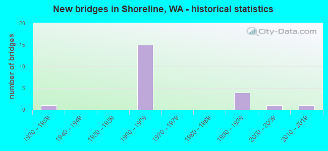
- New bridges - historical statistics
- 11930-1939
- 151960-1969
- 41990-1999
- 12000-2009
- 12010-2019
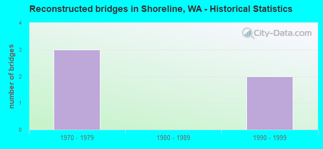
- Reconstructed bridges - Historical Statistics
- 31970-1979
- 01980-1989
- 21990-1999
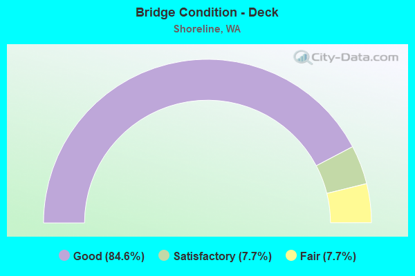
- Bridge Condition - Deck
- 84.6%Good
- 7.7%Satisfactory
- 7.7%Fair
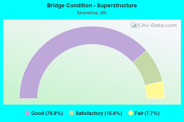
- Bridge Condition - Superstructure
- 76.9%Good
- 15.4%Satisfactory
- 7.7%Fair
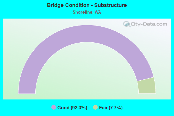
- Bridge Condition - Substructure
- 92.3%Good
- 7.7%Fair
Find on map >> Show street view
Structure Number: 7071A, Location: 3.1 N JCT SR 523 (Lat: 47.777389, Lng: -122.317750), Route carried "on" structure: Interstate 5, Year Built: 1963, Year Reconstructed: 1995, Status: Open, Structure Length: 6.10m (20.01ft), Average Daily Traffic: 81,740 (year 2019), Truck Traffic: 5%, Average Future Daily Traffic: 115,416 (year 2039), Design Load: HS 20, Features Intersected: SR 104 / NE 205TH ST
Minimum Vertical Clearance: 30+ m (98+ ft), Kilometerpoint: 286.061, Lanes on structure: 4, Lanes under structure: 6, Base Highway Network: Yes, Owner: State Highway Agency, Approaching Roadway Width: 20.7m (67.9ft), Material/Design: Prestressed concrete, Design/Construction: Stringer/Multi-beam, Number Of Spans In Main Unit: 3, Length of Maximum Span: 33.5m (109.9ft), Curb-To-Curb Width: 20.7m (67.9ft), Out-to-Out Width: 21.3m (69.9ft)
Condition: Deck: Good, Superstructure: Good, Substructure: Good, Operating Rating: 65.3 metric tons, Method Used To Determine Operating Rating: Load Factor (LF), Inventory Rating: 39.0 metric tons, Method Used To Determine Inventory Rating: Load Factor (LF), Structural Evaluation: Better than present minimum criteria, Deck Geometry: Equal to present minimum criteria, Underclear: Meets minimum limits, Approach Roadway Alignment: Equal to present desirable criteria, Length Of Structure Improvement: 6.10m (20.01ft), Designated Inspection Frequency: Every 24 months, Inspection Date: June 2021, Bridge Improvement Cost: $2,800,000, Roadway Improvement Cost: $560,000, Total Project Cost: $5,600,000 ( Estimate for 2014), Deck Structure Type: Concrete Cast-file-Place, Wearing Surface/Protective System: Wearing Surface: Latex Concrete
Find on map >> Show street view
Structure Number: 7071B, Location: 3.1 N JCT SR 523 (Lat: 47.777389, Lng: -122.318056), Route carried "on" structure: Interstate 5, Year Built: 1963, Year Reconstructed: 1983, Status: Open, Structure Length: 5.73m (18.80ft), Average Daily Traffic: 81,740 (year 2019), Truck Traffic: 5%, Average Future Daily Traffic: 115,416 (year 2039), Design Load: HS 20, Features Intersected: SR 104 / NE 205TH ST
Minimum Vertical Clearance: 30+ m (98+ ft), Kilometerpoint: 286.061, Lanes on structure: 4, Lanes under structure: 6, Base Highway Network: Yes, Owner: State Highway Agency, Approaching Roadway Width: 21.3m (69.9ft), Material/Design: Prestressed concrete, Design/Construction: Stringer/Multi-beam, Number Of Spans In Main Unit: 3, Length of Maximum Span: 33.5m (109.9ft), Curb-To-Curb Width: 20.4m (66.9ft), Out-to-Out Width: 21.2m (69.6ft)
Condition: Deck: Good, Superstructure: Good, Substructure: Good, Operating Rating: 34.7 metric tons, Method Used To Determine Operating Rating: Load and Resistance Factor Rating (LRFR) rating reported by rating factor(RF) method using HL-93 loadings, Inventory Rating: 26.9 metric tons, Method Used To Determine Inventory Rating: Load and Resistance Factor Rating (LRFR) rating reported by rating factor(RF) method using HL-93 loadings, Structural Evaluation: Equal to present minimum criteria, Deck Geometry: Equal to present minimum criteria, Underclear: Meets minimum limits, Approach Roadway Alignment: Equal to present desirable criteria, Length Of Structure Improvement: 5.73m (18.80ft), Designated Inspection Frequency: Every 24 months, Inspection Date: June 2021, Bridge Improvement Cost: $2,707,000, Roadway Improvement Cost: $541,000, Total Project Cost: $5,414,000 ( Estimate for 2014), Deck Structure Type: Concrete Cast-file-Place, Wearing Surface/Protective System: Wearing Surface: Latex Concrete
Find on map >> Show street view
Structure Number: 7071C, Location: 3.1 N JCT SR 523 (Lat: 47.777361, Lng: -122.317500), Route carried "on" structure: Ramp Interstate 5, Year Built: 1963, Year Reconstructed: 1995, Status: Open, Structure Length: 6.28m (20.60ft), Average Daily Traffic: 7,674 (year 2019), Truck Traffic: 5%, Average Future Daily Traffic: 10,835 (year 2039), Design Load: HS 20, Features Intersected: SR 104
Minimum Vertical Clearance: 30+ m (98+ ft), Kilometerpoint: 0.933, Lanes on structure: 2, Lanes under structure: 6, Owner: State Highway Agency, Approaching Roadway Width: 12.8m (42.0ft), Material/Design: Prestressed concrete, Design/Construction: Stringer/Multi-beam, Number Of Spans In Main Unit: 3, Length of Maximum Span: 32.9m (107.9ft), Curb-To-Curb Width: 12.8m (42.0ft), Out-to-Out Width: 13.7m (44.9ft)
Condition: Deck: Good, Superstructure: Good, Substructure: Good, Operating Rating: 67.1 metric tons, Method Used To Determine Operating Rating: Load Factor (LF), Inventory Rating: 39.9 metric tons, Method Used To Determine Inventory Rating: Load Factor (LF), Structural Evaluation: Better than present minimum criteria, Deck Geometry: Superior to present desirable criteria, Underclear: Meets minimum limits, Approach Roadway Alignment: Equal to present desirable criteria, Length Of Structure Improvement: 6.28m (20.60ft), Designated Inspection Frequency: Every 24 months, Inspection Date: June 2021, Bridge Improvement Cost: $1,813,000, Roadway Improvement Cost: $363,000, Total Project Cost: $3,626,000 ( Estimate for 2014), Deck Structure Type: Concrete Cast-file-Place, Wearing Surface/Protective System: Wearing Surface: Latex Concrete
Find on map >> Show street view
Structure Number: 7270C, Location: 0.5 N JCT SR 523 (Lat: 47.740989, Lng: -122.328722), Route carried "on" structure: Interstate 5, Year Built: 1964, Status: Open, Structure Length: 4.48m (14.70ft), Average Daily Traffic: 97,926 (year 2019), Truck Traffic: 5%, Average Future Daily Traffic: 138,271 (year 2039), Design Load: HS 20, Features Intersected: NE 155TH ST
Minimum Vertical Clearance: 30+ m (98+ ft), Kilometerpoint: 281.812, Lanes on structure: 5, Lanes under structure: 3, Base Highway Network: Yes, Owner: State Highway Agency, Approaching Roadway Width: 23.2m (76.1ft), Skew: 1 degrees, Material/Design: Concrete continuous, Design/Construction: Box Beam or Girders - Multiple, Number Of Spans In Main Unit: 3, Length of Maximum Span: 22.9m (75.1ft), Curb-To-Curb Width: 20.7m (67.9ft), Out-to-Out Width: 21.6m (70.9ft)
Condition: Deck: Good, Superstructure: Satisfactory, Substructure: Good, Operating Rating: 64.4 metric tons, Method Used To Determine Operating Rating: Load Factor (LF), Inventory Rating: 38.1 metric tons, Method Used To Determine Inventory Rating: Load Factor (LF), Structural Evaluation: Equal to present minimum criteria, Deck Geometry: Meets minimum limits, Underclear: Better than present minimum criteria, Approach Roadway Alignment: Equal to present desirable criteria, Length Of Structure Improvement: 4.48m (14.70ft), Designated Inspection Frequency: Every 24 months, Inspection Date: June 2021, Bridge Improvement Cost: $2,293,000, Roadway Improvement Cost: $459,000, Total Project Cost: $4,586,000 ( Estimate for 2014), Deck Structure Type: Concrete Cast-file-Place, Wearing Surface/Protective System: Wearing Surface: Other
Find on map >> Show street view
Structure Number: 7270D, Location: 0.5 N JCT SR 523 (Lat: 47.740958, Lng: -122.329025), Route carried "on" structure: Interstate 5, Year Built: 1964, Status: Open, Structure Length: 4.48m (14.70ft), Average Daily Traffic: 97,926 (year 2019), Truck Traffic: 5%, Average Future Daily Traffic: 138,271 (year 2039), Design Load: HS 20, Features Intersected: NE 155TH ST
Minimum Vertical Clearance: 30+ m (98+ ft), Kilometerpoint: 281.812, Lanes on structure: 4, Lanes under structure: 3, Base Highway Network: Yes, Owner: State Highway Agency, Approaching Roadway Width: 21.3m (69.9ft), Skew: 2 degrees, Material/Design: Concrete continuous, Design/Construction: Box Beam or Girders - Multiple, Number Of Spans In Main Unit: 3, Length of Maximum Span: 22.9m (75.1ft), Curb-To-Curb Width: 20.7m (67.9ft), Out-to-Out Width: 21.6m (70.9ft)
Condition: Deck: Good, Superstructure: Satisfactory, Substructure: Good, Operating Rating: 64.4 metric tons, Method Used To Determine Operating Rating: Load Factor (LF), Inventory Rating: 38.1 metric tons, Method Used To Determine Inventory Rating: Load Factor (LF), Structural Evaluation: Equal to present minimum criteria, Deck Geometry: Equal to present minimum criteria, Underclear: Superior to present desirable criteria, Approach Roadway Alignment: Equal to present desirable criteria, Length Of Structure Improvement: 4.48m (14.70ft), Designated Inspection Frequency: Every 24 months, Inspection Date: June 2021, Bridge Improvement Cost: $2,117,000, Roadway Improvement Cost: $423,000, Total Project Cost: $4,234,000 ( Estimate for 2014), Deck Structure Type: Concrete Cast-file-Place, Wearing Surface/Protective System: Wearing Surface: Other
Find on map >> Show street view
Structure Number: 7270E, Location: 1.0 E JCT SR 99 (Lat: 47.734086, Lng: -122.325394), Route carried "on" structure: State highway 523, Year Built: 1964, Status: Open, Structure Length: 7.59m (24.90ft), Average Daily Traffic: 30,279 (year 2019), Truck Traffic: 3%, Average Future Daily Traffic: 42,753 (year 2039), Design Load: HS 20, Features Intersected: I-5
Minimum Vertical Clearance: 30+ m (98+ ft), Kilometerpoint: 1.481, Lanes on structure: 5, Lanes under structure: 11, Base Highway Network: Yes, Owner: State Highway Agency, Approaching Roadway Width: 18.3m (60.0ft), Skew: 1 degrees, Material/Design: Concrete continuous, Design/Construction: Box Beam or Girders - Multiple, Number Of Spans In Main Unit: 4, Length of Maximum Span: 22.9m (75.1ft), Curb or Sidewalk Widths: Left: 1.8m (5.9ft), Right: 1.8m (5.9ft), Curb-To-Curb Width: 17.7m (58.1ft), Out-to-Out Width: 21.9m (71.9ft)
Condition: Deck: Good, Superstructure: Good, Substructure: Good, Operating Rating: 89.8 metric tons, Method Used To Determine Operating Rating: Load Factor (LF), Inventory Rating: 80.7 metric tons, Method Used To Determine Inventory Rating: Load Factor (LF), Structural Evaluation: Better than present minimum criteria, Deck Geometry: High priority of replacement, Underclear: High priority of corrective action, Approach Roadway Alignment: Equal to present desirable criteria, Length Of Structure Improvement: 7.59m (24.90ft), Designated Inspection Frequency: Every 24 months, Inspection Date: September 2021, Bridge Improvement Cost: $3,088,000, Roadway Improvement Cost: $618,000, Total Project Cost: $6,175,000 ( Estimate for 2014), Deck Structure Type: Concrete Cast-file-Place, Wearing Surface/Protective System: Wearing Surface: Latex Concrete
Find on map >> Show street view
Structure Number: 7299A, Location: 1.6 N JCT SR 523 (Lat: 47.755750, Lng: -122.329500), Route carried "on" structure: Interstate 5, Year Built: 1964, Year Reconstructed: 1983, Status: Open, Structure Length: 4.97m (16.31ft), Average Daily Traffic: 87,353 (year 2019), Truck Traffic: 5%, Average Future Daily Traffic: 123,342 (year 2039), Design Load: HS 20, Features Intersected: NE 175TH ST
Minimum Vertical Clearance: 30+ m (98+ ft), Kilometerpoint: 283.454, Lanes on structure: 4, Lanes under structure: 6, Base Highway Network: Yes, Owner: State Highway Agency, Approaching Roadway Width: 18.9m (62.0ft), Skew: 1 degrees, Material/Design: Concrete continuous, Design/Construction: Box Beam or Girders - Multiple, Number Of Spans In Main Unit: 3, Length of Maximum Span: 25.3m (83.0ft), Curb-To-Curb Width: 18.9m (62.0ft), Out-to-Out Width: 19.8m (65.0ft)
Condition: Deck: Good, Superstructure: Good, Substructure: Good, Operating Rating: 76.2 metric tons, Method Used To Determine Operating Rating: Load Factor (LF), Inventory Rating: 44.4 metric tons, Method Used To Determine Inventory Rating: Load Factor (LF), Structural Evaluation: Better than present minimum criteria, Deck Geometry: Meets minimum limits, Underclear: High priority of corrective action, Approach Roadway Alignment: Equal to present desirable criteria, Length Of Structure Improvement: 4.97m (16.31ft), Designated Inspection Frequency: Every 24 months, Inspection Date: June 2021, Bridge Improvement Cost: $2,086,000, Roadway Improvement Cost: $417,000, Total Project Cost: $4,173,000 ( Estimate for 2014), Deck Structure Type: Concrete Cast-file-Place, Wearing Surface/Protective System: Wearing Surface: Other
Find on map >> Show street view
Structure Number: 7299B, Location: 1.6 N JCT SR 523 (Lat: 47.755750, Lng: -122.329806), Route carried "on" structure: Interstate 5, Year Built: 1964, Year Reconstructed: 1983, Status: Open, Structure Length: 4.97m (16.31ft), Average Daily Traffic: 87,353 (year 2019), Truck Traffic: 5%, Average Future Daily Traffic: 123,342 (year 2039), Design Load: HS 20, Features Intersected: NE 175TH ST
Minimum Vertical Clearance: 30+ m (98+ ft), Kilometerpoint: 283.454, Lanes on structure: 4, Lanes under structure: 6, Base Highway Network: Yes, Owner: State Highway Agency, Approaching Roadway Width: 22.6m (74.1ft), Skew: 1 degrees, Material/Design: Concrete continuous, Design/Construction: Box Beam or Girders - Multiple, Number Of Spans In Main Unit: 3, Length of Maximum Span: 25.3m (83.0ft), Curb-To-Curb Width: 18.9m (62.0ft), Out-to-Out Width: 19.8m (65.0ft)
Condition: Deck: Good, Superstructure: Good, Substructure: Good, Operating Rating: 76.2 metric tons, Method Used To Determine Operating Rating: Load Factor (LF), Inventory Rating: 44.4 metric tons, Method Used To Determine Inventory Rating: Load Factor (LF), Structural Evaluation: Better than present minimum criteria, Deck Geometry: Meets minimum limits, Underclear: Meets minimum limits, Approach Roadway Alignment: Equal to present desirable criteria, Length Of Structure Improvement: 4.97m (16.31ft), Designated Inspection Frequency: Every 24 months, Inspection Date: June 2021, Bridge Improvement Cost: $2,478,000, Roadway Improvement Cost: $496,000, Total Project Cost: $4,955,000 ( Estimate for 2014), Deck Structure Type: Concrete Cast-file-Place, Wearing Surface/Protective System: Wearing Surface: Epoxy Overlay
Find on map >> Show street view
Structure Number: 7299C, Location: 2.1 N JCT SR 523 (Lat: 47.763250, Lng: -122.324306), Route carried "on" structure: City street , Year Built: 1964, Status: Open, Structure Length: 7.59m (24.90ft), Average Daily Traffic: 9,704 (year 2010), Truck Traffic: 5%, Average Future Daily Traffic: 15,255 (year 2036), Design Load: HS 20, Features Intersected: I-5, Facility Carried by Structure: NE 185TH ST
Minimum Vertical Clearance: 30+ m (98+ ft), Kilometerpoint: 5.472, Lanes on structure: 2, Lanes under structure: 9, Owner: State Highway Agency, Approaching Roadway Width: 17.7m (58.1ft), Skew: 1 degrees, Material/Design: Concrete continuous, Design/Construction: Box Beam or Girders - Multiple, Number Of Spans In Main Unit: 4, Length of Maximum Span: 22.9m (75.1ft), Curb or Sidewalk Widths: Left: 1.8m (5.9ft), Right: 1.8m (5.9ft), Curb-To-Curb Width: 14.0m (45.9ft), Out-to-Out Width: 18.3m (60.0ft)
Condition: Deck: Satisfactory, Superstructure: Good, Substructure: Good, Operating Rating: 54.4 metric tons, Method Used To Determine Operating Rating: Load Factor (LF), Inventory Rating: 32.7 metric tons, Method Used To Determine Inventory Rating: Load Factor (LF), Structural Evaluation: Better than present minimum criteria, Deck Geometry: Superior to present desirable criteria, Underclear: High priority of corrective action, Approach Roadway Alignment: Equal to present desirable criteria, Length Of Structure Improvement: 7.59m (24.90ft), Designated Inspection Frequency: Every 24 months, Inspection Date: June 2021, Bridge Improvement Cost: $2,988,000, Roadway Improvement Cost: $598,000, Total Project Cost: $5,976,000 ( Estimate for 2014), Deck Structure Type: Concrete Cast-file-Place, Wearing Surface/Protective System: Wearing Surface: Monolithic Concrete
Find on map >> Show street view
Structure Number: 13302A, Location: 0.9 N JCT SR 523 (Lat: 47.746914, Lng: -122.329239), Route carried "on" structure: Interstate 5, Year Built: 1990, Status: Open, Structure Length: 1.22m (4.00ft), Average Daily Traffic: 194,946 (year 2019), Truck Traffic: 5%, Average Future Daily Traffic: 275,263 (year 2039), Design Load: HS 20+Mod, Features Intersected: METRO ACCESS
Minimum Vertical Clearance: 30+ m (98+ ft), Kilometerpoint: 282.472, Lanes on structure: 9, Lanes under structure: 2, Base Highway Network: Yes, Owner: State Highway Agency, Approaching Roadway Width: 42.1m (138.1ft), Skew: 30 degrees, Material/Design: Concrete, Design/Construction: Slab, Number Of Spans In Main Unit: 1, Length of Maximum Span: 11.3m (37.1ft), Curb-To-Curb Width: 42.1m (138.1ft), Out-to-Out Width: 43.0m (141.1ft)
Condition: Deck: Good, Superstructure: Good, Substructure: Good, Operating Rating: 39.9 metric tons, Method Used To Determine Operating Rating: Load and Resistance Factor Rating (LRFR) rating reported by rating factor(RF) method using HL-93 loadings, Inventory Rating: 30.8 metric tons, Method Used To Determine Inventory Rating: Load and Resistance Factor Rating (LRFR) rating reported by rating factor(RF) method using HL-93 loadings, Structural Evaluation: Better than present minimum criteria, Deck Geometry: Superior to present desirable criteria, Underclear: High priority of corrective action, Approach Roadway Alignment: Equal to present desirable criteria, Length Of Structure Improvement: 1.22m (4.00ft), Designated Inspection Frequency: Every 24 months, Inspection Date: November 2020, Bridge Improvement Cost: $1,120,000, Roadway Improvement Cost: $224,000, Total Project Cost: $2,240,000 ( Estimate for 2014), Deck Structure Type: Concrete Cast-file-Place, Wearing Surface/Protective System: Wearing Surface: Monolithic Concrete, Deck Protection: Epoxy Coated Reinforcing
Find on map >> Show street view
Structure Number: 14326C, Location: 3.2 N JCT SR 523 (Lat: 47.777389, Lng: -122.318333), Route carried "on" structure: Ramp Interstate 5, Year Built: 1995, Status: Open, Structure Length: 5.76m (18.90ft), Average Daily Traffic: 7,005 (year 2019), Truck Traffic: 5%, Average Future Daily Traffic: 10,143 (year 2039), Design Load: HS 25 or greater, Features Intersected: SR 104/205TH ST
Minimum Vertical Clearance: 30+ m (98+ ft), Kilometerpoint: 0.789, Lanes on structure: 3, Lanes under structure: 6, Owner: State Highway Agency, Approaching Roadway Width: 14.9m (48.9ft), Material/Design: Prestressed concrete, Design/Construction: Stringer/Multi-beam, Number Of Spans In Main Unit: 3, Length of Maximum Span: 34.4m (112.9ft), Curb-To-Curb Width: 14.8m (48.6ft), Out-to-Out Width: 16.4m (53.8ft)
Condition: Deck: Good, Superstructure: Good, Substructure: Good, Operating Rating: 67.1 metric tons, Method Used To Determine Operating Rating: Load Factor (LF), Inventory Rating: 39.9 metric tons, Method Used To Determine Inventory Rating: Load Factor (LF), Structural Evaluation: Better than present minimum criteria, Deck Geometry: Equal to present desirable criteria, Underclear: Equal to present minimum criteria, Approach Roadway Alignment: Equal to present desirable criteria, Length Of Structure Improvement: 5.76m (18.90ft), Designated Inspection Frequency: Every 24 months, Inspection Date: June 2021, Bridge Improvement Cost: $1,928,000, Roadway Improvement Cost: $386,000, Total Project Cost: $3,856,000 ( Estimate for 2014), Deck Structure Type: Concrete Cast-file-Place, Wearing Surface/Protective System: Wearing Surface: Monolithic Concrete, Deck Protection: Epoxy Coated Reinforcing
Find on map >> Show street view
Structure Number: 81372, Location: 0.1 MI W OF NW INNIS ARD (Lat: 47.751944, Lng: -122.372583), Route carried "on" structure: County highway 1169, Year Built: 1931, Status: Posted for load, Structure Length: 9.51m (31.20ft), Average Daily Traffic: 730 (year 2019), Truck Traffic: 4%, Average Future Daily Traffic: 850 (year 2039), Design Load: HS 15, Features Intersected: SIDE HILL RAVINE, Facility Carried by Structure: 10TH AVENUE NW
Minimum Vertical Clearance: 30+ m (98+ ft), Kilometerpoint: 0.001, Lanes on structure: 2, Owner: City or Municipal Highway Agency, Approaching Roadway Width: 6.7m (22.0ft), Material/Design: Concrete continuous, Design/Construction: Slab, Number Of Spans In Main Unit: 10, Length of Maximum Span: 9.1m (29.9ft), Curb-To-Curb Width: 6.1m (20.0ft), Out-to-Out Width: 6.7m (22.0ft)
Condition: Deck: Fair, Superstructure: Fair, Substructure: Fair, Operating Rating: 24.6 metric tons, Method Used To Determine Operating Rating: Load and Resistance Factor Rating (LRFR) rating reported by rating factor(RF) method using HL-93 loadings, Inventory Rating: 14.9 metric tons, Method Used To Determine Inventory Rating: Load and Resistance Factor Rating (LRFR) rating reported by rating factor(RF) method using HL-93 loadings, Structural Evaluation: Meets minimum limits, Deck Geometry: High priority of corrective action, Approach Roadway Alignment: Equal to present minimum criteria, Bridge Posting: Required (Relationship of Operating Rating to Maximum Legal Load: > 39.9% below), Length Of Structure Improvement: 9.81m (32.19ft), Designated Inspection Frequency: Every 24 months, Inspection Date: June 2020, Bridge Improvement Cost: $4,894,000, Roadway Improvement Cost: $979,000, Total Project Cost: $9,789,000 ( Estimate for 2014), Deck Structure Type: Concrete Cast-file-Place, Wearing Surface/Protective System: Wearing Surface: Bituminous
Find on map >> Show street view
Structure Number: 88481, Location: JCT RICH BEACH DR NW (Lat: 47.771186, Lng: -122.392458), Route carried "on" structure: City street 58695, Year Built: 2011, Status: Open, Structure Length: 1.62m (5.31ft), Average Daily Traffic: 650 (year 2020), Truck Traffic: 5%, Average Future Daily Traffic: 800 (year 2040), Design Load: HL 93, Features Intersected: BNSF RR, Facility Carried by Structure: NW 195TH CT
Minimum Vertical Clearance: 30+ m (98+ ft), Kilometerpoint: 0.001, Lanes on structure: 2, Owner: City or Municipal Highway Agency, Approaching Roadway Width: 7.3m (24.0ft), Material/Design: Concrete, Design/Construction: Arch - Thru, Number Of Spans In Main Unit: 1, Length of Maximum Span: 15.5m (50.9ft), Curb or Sidewalk Widths: Left: 0.0m, Right: 1.8m (5.9ft), Curb-To-Curb Width: 7.3m (24.0ft), Out-to-Out Width: 9.1m (29.9ft)
Condition: Deck: Good, Superstructure: Good, Substructure: Good, Operating Rating: 68.0 metric tons, Method Used To Determine Operating Rating: Load and Resistance Factor (LRFR), Inventory Rating: 40.8 metric tons, Method Used To Determine Inventory Rating: Load and Resistance Factor (LRFR), Structural Evaluation: Better than present minimum criteria, Deck Geometry: Meets minimum limits, Underclear: Equal to present minimum criteria, Approach Roadway Alignment: High priority of corrective action, Length Of Structure Improvement: 1.62m (5.31ft), Designated Inspection Frequency: Every 24 months, Inspection Date: June 2020, Bridge Improvement Cost: $276,000, Roadway Improvement Cost: $55,000, Total Project Cost: $551,000 ( Estimate for 2014), Deck Structure Type: Concrete Cast-file-Place, Wearing Surface/Protective System: Wearing Surface: Monolithic Concrete, Deck Protection: Epoxy Coated Reinforcing
Find on map >> Show street view
Structure Number: 7071A, Location: 1.3 E JCT SR 99 (Lat: 47.777389, Lng: -122.317750), Route carried "under" structure: State highway 104, Year Built: 1963, Structure Length: 0. m, Average Daily Traffic: 48,479 (year 2019), Truck Traffic: 2%, Features Intersected: SR 104 / NE 205TH ST, Facility Carried by Structure: I-5
Minimum Vertical Clearance: 5.69m (18.67ft), Kilometerpoint: 47.749, Lanes on structure: 4, Lanes under structure: 6, Material/Design: Prestressed concrete, Design/Construction: Stringer/Multi-beam, Length of Maximum Span: 33.5m (109.9ft)
Find on map >> Show street view
Structure Number: 7071B, Location: 1.3 E JCT SR 99 (Lat: 47.777389, Lng: -122.318056), Route carried "under" structure: State highway 104, Year Built: 1963, Structure Length: 0. m, Average Daily Traffic: 48,479 (year 2019), Truck Traffic: 2%, Features Intersected: SR 104 / NE 205TH ST, Facility Carried by Structure: I-5
Minimum Vertical Clearance: 5.03m (16.50ft), Kilometerpoint: 47.717, Lanes on structure: 4, Lanes under structure: 6, Material/Design: Prestressed concrete, Design/Construction: Stringer/Multi-beam, Length of Maximum Span: 33.5m (109.9ft)
Find on map >> Show street view
Structure Number: 7071C, Location: 1.3 E JCT SR 99 (Lat: 47.777361, Lng: -122.317500), Route carried "under" structure: State highway 104, Year Built: 1963, Structure Length: 0. m, Average Daily Traffic: 48,479 (year 2019), Truck Traffic: 2%, Features Intersected: SR 104, Facility Carried by Structure: I-5 NBCD
Minimum Vertical Clearance: 6.05m (19.85ft), Kilometerpoint: 47.765, Lanes on structure: 2, Lanes under structure: 6, Material/Design: Prestressed concrete, Design/Construction: Stringer/Multi-beam, Length of Maximum Span: 32.9m (107.9ft)
Find on map >> Show street view
Structure Number: 7270E, Location: 3.8 N JCT SR 522 (Lat: 47.734086, Lng: -122.325394), Route carried "under" structure: Interstate 5, Year Built: 1964, Structure Length: 0. m, Average Daily Traffic: 175,081 (year 2019), Truck Traffic: 5%, Features Intersected: I-5
Minimum Vertical Clearance: 6.58m (21.59ft), Kilometerpoint: 280.959, Lanes on structure: 5, Lanes under structure: 11, Material/Design: Concrete continuous, Design/Construction: Box Beam or Girders - Multiple, Length of Maximum Span: 22.9m (75.1ft)
Find on map >> Show street view
Structure Number: 7299C, Location: 2.6 N JCT SR 523 (Lat: 47.763250, Lng: -122.324306), Route carried "under" structure: Interstate 5, Year Built: 1964, Structure Length: 0. m, Average Daily Traffic: 189,639 (year 2019), Truck Traffic: 5%, Features Intersected: I-5
Minimum Vertical Clearance: 6.63m (21.75ft), Kilometerpoint: 284.403, Lanes on structure: 2, Lanes under structure: 9, Material/Design: Concrete continuous, Design/Construction: Box Beam or Girders - Multiple, Length of Maximum Span: 22.9m (75.1ft)
Find on map >> Show street view
Structure Number: 7299D, Location: 2.6 N JCT SR 523 (Lat: 47.770250, Lng: -122.321667), Route carried "under" structure: Interstate 5, Year Built: 1964, Structure Length: 0. m, Average Daily Traffic: 163,479 (year 2019), Truck Traffic: 5%, Features Intersected: I-5
Minimum Vertical Clearance: 6.63m (21.75ft), Kilometerpoint: 285.192, Lanes under structure: 9, Material/Design: Prestressed concrete continuous, Design/Construction: Stringer/Multi-beam, Length of Maximum Span: 29.0m (95.1ft)
Find on map >> Show street view
Structure Number: 13302A, Location: 0.9 N JCT SR 523 (Lat: 47.746914, Lng: -122.329239), Route carried "under" structure: Ramp Interstate , Year Built: 1990, Structure Length: 0. m, Average Daily Traffic: 1,144 (year 2020), Truck Traffic: 75%, Features Intersected: METRO ACCESS, Facility Carried by Structure: I-5
Minimum Vertical Clearance: 5.05m (16.57ft), Kilometerpoint: 0.032, Lanes on structure: 9, Lanes under structure: 2, Material/Design: Concrete, Design/Construction: Slab, Length of Maximum Span: 11.3m (37.1ft)
Find on map >> Show street view
Structure Number: 14326C, Location: 1.2 E JCT SR 99 (Lat: 47.777389, Lng: -122.318333), Route carried "under" structure: State highway 104, Year Built: 1995, Structure Length: 0. m, Average Daily Traffic: 48,479 (year 2019), Truck Traffic: 2%, Features Intersected: SR 104/205TH ST, Facility Carried by Structure: I-5 SBCD
Minimum Vertical Clearance: 5.26m (17.26ft), Kilometerpoint: 47.685, Lanes on structure: 3, Lanes under structure: 6, Material/Design: Prestressed concrete, Design/Construction: Stringer/Multi-beam, Length of Maximum Span: 34.4m (112.9ft)
Find on map >> Show street view
Structure Number: 200412, Location: 14.7 N JCT SR 509 (Lat: 47.743417, Lng: -122.345444), Route carried "under" structure: State highway 99, Year Built: 2009, Structure Length: 0. m, Average Daily Traffic: 33,038 (year 2019), Truck Traffic: 3%, Features Intersected: AURORA AVE/SR 99, Facility Carried by Structure: INTERURBAN TRAIL
Minimum Vertical Clearance: 5.41m (17.75ft), Kilometerpoint: 66.160, Lanes under structure: 6, Material/Design: Prestressed concrete, Design/Construction: Box Beam or Girders - Single/Spread, Length of Maximum Span: 41.1m (134.8ft)