Bridge Statistics for Shorewood, Illinois (IL)
Condition, Traffic, Stress, Structural Evaluation, Project Costs
- National Bridge Inventory (NBI) Statistics
- 14Number of bridges
- 246ft / 74.8mTotal length
- $761,000Total costs
- 288,450Total average daily traffic
- 46,053Total average daily truck traffic
- National Bridge Inventory (NBI) Registered Bridges for Shorewood
- No street view available for this location
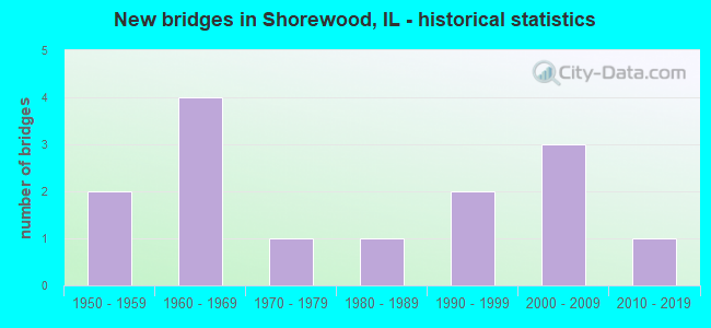
- New bridges - historical statistics
- 21950-1959
- 41960-1969
- 11970-1979
- 11980-1989
- 21990-1999
- 32000-2009
- 12010-2019

- Reconstructed bridges - Historical Statistics
- 21970-1979
- 11980-1989


- Bridge Condition - Deck
- 55.6%Satisfactory
- 22.2%Fair
- 11.1%Poor
- 11.1%Critical

- Bridge Condition - Superstructure
- 10.0%Very good
- 50.0%Satisfactory
- 20.0%Fair
- 10.0%Serious
- 10.0%Critical

- Bridge Condition - Substructure
- 20.0%Very good
- 40.0%Good
- 30.0%Satisfactory
- 10.0%Fair

- Bridge Condition - Channel
- 30.0%Very good
- 10.0%Good
- 60.0%Satisfactory
Find on map >> Show street view
Structure Number: 99004, Location: 0.8 M W OF I-55 (Lat: 41.485706, Lng: -88.212036), Route carried "on" structure: Interstate 80, Year Built: 1960, Year Reconstructed: 1982, Status: Open, Structure Length: 8.92m (29.27ft), Average Daily Traffic: 28,700 (year 2019), Truck Traffic: 24%, Average Future Daily Traffic: 30,642 (year 2032), Design Load: HS 20+Mod, Features Intersected: DUPAGE RIVER
Minimum Vertical Clearance: 30+ m (98+ ft), Kilometerpoint: 202.032, Lanes on structure: 2, Base Highway Network: Yes, Owner: State Highway Agency, Approaching Roadway Width: 12.8m (42.0ft), Material/Design: Prestressed concrete continuous, Design/Construction: Stringer/Multi-beam, Number Of Spans In Main Unit: 5, Length of Maximum Span: 17.7m (58.1ft), Curb-To-Curb Width: 12.8m (42.0ft), Out-to-Out Width: 13.8m (45.3ft)
Condition: Deck: Fair, Superstructure: Serious, Substructure: Satisfactory, Channel: Satisfactory, Operating Rating: 66.1 metric tons, Method Used To Determine Operating Rating: Load Factor (LF) rating reported by rating factor (RF) method using MS18 loading, Inventory Rating: 39.5 metric tons, Method Used To Determine Inventory Rating: Load Factor (LF) rating reported by rating factor (RF) method using MS18 loading, Structural Evaluation: High priority of corrective action, Deck Geometry: Equal to present desirable criteria, Waterway Adequacy: Better than present minimum criteria, Approach Roadway Alignment: Equal to present desirable criteria, Designated Inspection Frequency: Every 12 months, Inspection Date: October 2021, Deck Structure Type: Concrete Cast-file-Place, Wearing Surface/Protective System: Wearing Surface: Latex Concrete, Deck Protection: Epoxy Coated Reinforcing
Find on map >> Show street view
Structure Number: 990041, Location: 0.8 M W OF I-55 (Lat: 41.485708, Lng: -88.211842), Route carried "on" structure: Interstate 80, Year Built: 1960, Year Reconstructed: 1982, Status: Open, Structure Length: 8.92m (29.27ft), Average Daily Traffic: 28,700 (year 2019), Truck Traffic: 24%, Average Future Daily Traffic: 30,642 (year 2032), Design Load: HS 20+Mod, Features Intersected: DUPAGE RIVER
Minimum Vertical Clearance: 30+ m (98+ ft), Kilometerpoint: 202.048, Lanes on structure: 2, Base Highway Network: Yes, Owner: State Highway Agency, Approaching Roadway Width: 12.8m (42.0ft), Material/Design: Prestressed concrete continuous, Design/Construction: Stringer/Multi-beam, Number Of Spans In Main Unit: 5, Length of Maximum Span: 17.7m (58.1ft), Curb-To-Curb Width: 12.8m (42.0ft), Out-to-Out Width: 13.8m (45.3ft)
Condition: Deck: Satisfactory, Superstructure: Fair, Substructure: Satisfactory, Channel: Satisfactory, Operating Rating: 89.1 metric tons, Method Used To Determine Operating Rating: Load Factor (LF) rating reported by rating factor (RF) method using MS18 loading, Inventory Rating: 56.7 metric tons, Method Used To Determine Inventory Rating: Load Factor (LF) rating reported by rating factor (RF) method using MS18 loading, Structural Evaluation: Somewhat better than minimum adequacy, Deck Geometry: Equal to present desirable criteria, Waterway Adequacy: Better than present minimum criteria, Approach Roadway Alignment: Equal to present desirable criteria, Designated Inspection Frequency: Every 24 months, Inspection Date: October 2020, Deck Structure Type: Concrete Cast-file-Place, Wearing Surface/Protective System: Wearing Surface: Latex Concrete, Deck Protection: Epoxy Coated Reinforcing
Find on map >> Show street view
Structure Number: 990139, Location: 2.4 M N OF I-80 (Lat: 41.521639, Lng: -88.188769), Route carried "on" structure: US 52, Year Built: 1956, Year Reconstructed: 1994, Status: Open, Structure Length: 6.72m (22.05ft), Average Daily Traffic: 25,100 (year 2021), Truck Traffic: 6%, Average Future Daily Traffic: 41,200 (year 2041), Design Load: HS 20, Features Intersected: I- 55
Minimum Vertical Clearance: 30+ m (98+ ft), Kilometerpoint: 216.853, Lanes on structure: 5, Lanes under structure: 6, Base Highway Network: Yes, Owner: State Highway Agency, Approaching Roadway Width: 19.5m (64.0ft), Skew: 32 degrees, Material/Design: Steel continuous, Design/Construction: Stringer/Multi-beam, Number Of Spans In Main Unit: 4, Length of Maximum Span: 18.3m (60.0ft), Curb-To-Curb Width: 19.5m (64.0ft), Out-to-Out Width: 21.7m (71.2ft)
Condition: Deck: Satisfactory, Superstructure: Satisfactory, Substructure: Satisfactory, Operating Rating: 63.2 metric tons, Method Used To Determine Operating Rating: Load Factor (LF) rating reported by rating factor (RF) method using MS18 loading, Inventory Rating: 37.9 metric tons, Method Used To Determine Inventory Rating: Load Factor (LF) rating reported by rating factor (RF) method using MS18 loading, Structural Evaluation: Equal to present minimum criteria, Deck Geometry: Meets minimum limits, Underclear: High priority of corrective action, Approach Roadway Alignment: Equal to present desirable criteria, Designated Inspection Frequency: Every 24 months, Inspection Date: December 2020, Deck Structure Type: Concrete Cast-file-Place, Wearing Surface/Protective System: Deck Protection: Epoxy Coated Reinforcing
Find on map >> Show street view
Structure Number: 990177, Location: 1.0 M W OF I-55 (Lat: 41.486086, Lng: -88.216494), Route carried "on" structure: County highway , Year Built: 1960, Status: Open, Structure Length: 6.69m (21.95ft), Average Daily Traffic: 1,750 (year 2019), Truck Traffic: 9%, Average Future Daily Traffic: 2,146 (year 2032), Design Load: HS 15, Features Intersected: I- 80, Facility Carried by Structure: RIVER RD
Minimum Vertical Clearance: 30+ m (98+ ft), Kilometerpoint: 0.000, Lanes on structure: 2, Lanes under structure: 4, Owner: State Highway Agency, Approaching Roadway Width: 7.3m (24.0ft), Material/Design: Prestressed concrete, Design/Construction: Stringer/Multi-beam, Number Of Spans In Main Unit: 4, Length of Maximum Span: 20.6m (67.6ft), Curb-To-Curb Width: 7.3m (24.0ft), Out-to-Out Width: 9.1m (29.9ft)
Condition: Deck: Poor, Superstructure: Fair, Substructure: Fair, Operating Rating: 84.9 metric tons, Method Used To Determine Operating Rating: Load Factor (LF) rating reported by rating factor (RF) method using MS18 loading, Inventory Rating: 44.4 metric tons, Method Used To Determine Inventory Rating: Load Factor (LF) rating reported by rating factor (RF) method using MS18 loading, Structural Evaluation: Somewhat better than minimum adequacy, Deck Geometry: Meets minimum limits, Underclear: High priority of corrective action, Approach Roadway Alignment: Equal to present minimum criteria, Length Of Structure Improvement: 6.71m (22.01ft), Designated Inspection Frequency: Every 24 months, Inspection Date: August 2020, Bridge Improvement Cost: $507,000, Roadway Improvement Cost: $51,000, Total Project Cost: $761,000, Deck Structure Type: Concrete Cast-file-Place, Wearing Surface/Protective System: Wearing Surface: Bituminous
Find on map >> Show street view
Structure Number: 990276, Location: 0.2 M E OF IL 59 (Lat: 41.521589, Lng: -88.195986), Route carried "on" structure: US 52, Year Built: 1990, Status: Open, Structure Length: 14.02m (46.00ft), Average Daily Traffic: 24,900 (year 2021), Truck Traffic: 5%, Average Future Daily Traffic: 17,567 (year 2032), Design Load: HS 20, Features Intersected: DU PAGE RIVER
Minimum Vertical Clearance: 30+ m (98+ ft), Kilometerpoint: 216.290, Lanes on structure: 2, Base Highway Network: Yes, Owner: State Highway Agency, Approaching Roadway Width: 20.7m (67.9ft), Skew: 36 degrees, Material/Design: Steel continuous, Design/Construction: Stringer/Multi-beam, Number Of Spans In Main Unit: 4, Length of Maximum Span: 38.1m (125.0ft), Curb or Sidewalk Widths: Left: 0.0m, Right: 1.5m (4.9ft), Curb-To-Curb Width: 16.5m (54.1ft), Out-to-Out Width: 23.0m (75.5ft)
Condition: Deck: Satisfactory, Superstructure: Satisfactory, Substructure: Good, Channel: Satisfactory, Operating Rating: 71.6 metric tons, Method Used To Determine Operating Rating: Load Factor (LF) rating reported by rating factor (RF) method using MS18 loading, Inventory Rating: 37.9 metric tons, Method Used To Determine Inventory Rating: Load Factor (LF) rating reported by rating factor (RF) method using MS18 loading, Structural Evaluation: Equal to present minimum criteria, Deck Geometry: Superior to present desirable criteria, Waterway Adequacy: Equal to present desirable criteria, Approach Roadway Alignment: Equal to present desirable criteria, Designated Inspection Frequency: Every 24 months, Inspection Date: Febuary 2021, Deck Structure Type: Concrete Cast-file-Place, Wearing Surface/Protective System: Deck Protection: Epoxy Coated Reinforcing
Find on map >> Show street view
Structure Number: 990284, Location: 0.1 M S US 52 (Lat: 41.520303, Lng: -88.198603), Route carried "on" structure: State highway 59, Year Built: 1991, Status: Open, Structure Length: 7.38m (24.21ft), Average Daily Traffic: 20,600 (year 2021), Truck Traffic: 6%, Average Future Daily Traffic: 22,529 (year 2032), Design Load: HS 20, Features Intersected: DU PAGE RIVER
Minimum Vertical Clearance: 30+ m (98+ ft), Kilometerpoint: 1.513, Lanes on structure: 4, Base Highway Network: Yes, Owner: State Highway Agency, Approaching Roadway Width: 20.1m (65.9ft), Skew: 32 degrees, Material/Design: Prestressed concrete continuous, Design/Construction: Stringer/Multi-beam, Number Of Spans In Main Unit: 4, Length of Maximum Span: 18.1m (59.4ft), Curb or Sidewalk Widths: Left: 1.5m (4.9ft), Right: 0.0m, Curb-To-Curb Width: 20.1m (65.9ft), Out-to-Out Width: 23.0m (75.5ft)
Condition: Deck: Satisfactory, Superstructure: Satisfactory, Substructure: Good, Channel: Satisfactory, Operating Rating: 55.1 metric tons, Method Used To Determine Operating Rating: Load Factor (LF) rating reported by rating factor (RF) method using MS18 loading, Inventory Rating: 34.3 metric tons, Method Used To Determine Inventory Rating: Load Factor (LF) rating reported by rating factor (RF) method using MS18 loading, Structural Evaluation: Equal to present minimum criteria, Deck Geometry: Better than present minimum criteria, Waterway Adequacy: Equal to present minimum criteria, Approach Roadway Alignment: Equal to present desirable criteria, Designated Inspection Frequency: Every 24 months, Inspection Date: November 2020, Deck Structure Type: Concrete Cast-file-Place, Wearing Surface/Protective System: Deck Protection: Epoxy Coated Reinforcing
Find on map >> Show street view
Structure Number: 994251, Location: 300FT E OF RIVER RD (Lat: 41.492378, Lng: -88.215728), Route carried "on" structure: City street , Year Built: 1978, Status: Open, Structure Length: 6.23m (20.44ft), Average Daily Traffic: 1,200 (year 2019), Truck Traffic: 5%, Average Future Daily Traffic: 1,050 (year 2032), Design Load: HS 20, Features Intersected: DUPAGE RIVER, Facility Carried by Structure: MOUND ROAD
Minimum Vertical Clearance: 30+ m (98+ ft), Kilometerpoint: 1.706, Lanes on structure: 2, Owner: City or Municipal Highway Agency, Approaching Roadway Width: 8.2m (26.9ft), Skew: 2 degrees, Material/Design: Steel continuous, Design/Construction: Stringer/Multi-beam, Number Of Spans In Main Unit: 3, Length of Maximum Span: 23.5m (77.1ft), Curb-To-Curb Width: 8.8m (28.9ft), Out-to-Out Width: 9.8m (32.2ft)
Condition: Deck: Fair, Superstructure: Satisfactory, Substructure: Good, Channel: Satisfactory, Operating Rating: 53.8 metric tons, Method Used To Determine Operating Rating: Assigned rating based on Load Factor Design (LFD) reported by rating factor (RF) using MS18 loading, Inventory Rating: 32.4 metric tons, Method Used To Determine Inventory Rating: Assigned rating based on Load Factor Design (LFD) reported by rating factor (RF) using MS18 loading, Structural Evaluation: Equal to present minimum criteria, Deck Geometry: Somewhat better than minimum adequacy, Waterway Adequacy: Better than present minimum criteria, Approach Roadway Alignment: Equal to present desirable criteria, Designated Inspection Frequency: Every 24 months, Inspection Date: April 2021, Deck Structure Type: Concrete Cast-file-Place, Wearing Surface/Protective System: Wearing Surface: Other
Find on map >> Show street view
Structure Number: 994253, Location: 0.5 MI W I-55 (Lat: 41.507456, Lng: -88.208444), Route carried "on" structure: Other road , Year Built: 1982, Status: Posted for load, Structure Length: 5.67m (18.60ft), Average Daily Traffic: 6,650 (year 2019), Truck Traffic: 4%, Average Future Daily Traffic: 5,163 (year 2032), Design Load: HS 20, Features Intersected: DUPAGE RIVER, Facility Carried by Structure: SEIL RD/COUNTY FAR
Minimum Vertical Clearance: 30+ m (98+ ft), Kilometerpoint: 2.639, Lanes on structure: 2, Owner: City or Municipal Highway Agency, Approaching Roadway Width: 9.4m (30.8ft), Skew: 2 degrees, Material/Design: Prestressed concrete, Design/Construction: Box Beam or Girders - Multiple, Number Of Spans In Main Unit: 3, Length of Maximum Span: 18.9m (62.0ft), Curb-To-Curb Width: 9.9m (32.5ft), Out-to-Out Width: 9.9m (32.5ft)
Condition: Deck: Critical, Superstructure: Critical, Substructure: Good, Channel: Good, Operating Rating: 19.4 metric tons, Method Used To Determine Operating Rating: Load Factor (LF) rating reported by rating factor (RF) method using MS18 loading, Inventory Rating: 11.7 metric tons, Method Used To Determine Inventory Rating: Load Factor (LF) rating reported by rating factor (RF) method using MS18 loading, Structural Evaluation: High priority of replacement, Deck Geometry: Meets minimum limits, Waterway Adequacy: Equal to present desirable criteria, Approach Roadway Alignment: Equal to present desirable criteria, Bridge Posting: Required (Relationship of Operating Rating to Maximum Legal Load: 30.0 - 39.9% below), Designated Inspection Frequency: Every 24 months, Other Special Inspection Frequency: Every 12 months, Inspection Date: April 2021, Other Special Inspection Date: April 2021, Deck Structure Type: Concrete Precast Panels, Wearing Surface/Protective System: Wearing Surface: Bituminous
Find on map >> Show street view
Structure Number: 99466, Location: 0.24 M N OF US 52 (Lat: 41.524878, Lng: -88.198789), Route carried "on" structure: State highway 59, Year Built: 2010, Status: Open, Structure Length: 1.94m (6.36ft), Average Daily Traffic: 26,700 (year 2021), Truck Traffic: 4%, Average Future Daily Traffic: 30,307 (year 2032), Design Load: HS 20, Features Intersected: HAMMEL CREEK
Minimum Vertical Clearance: 30+ m (98+ ft), Kilometerpoint: 2.012, Lanes on structure: 4, Base Highway Network: Yes, Owner: State Highway Agency, Approaching Roadway Width: 19.5m (64.0ft), Skew: 5 degrees, Material/Design: Concrete continuous, Design/Construction: Culvert, Number Of Spans In Main Unit: 3, Length of Maximum Span: 7.0m (23.0ft)
Condition: Channel: Very good, Culverts: Good, Operating Rating: 97.2 metric tons, Method Used To Determine Operating Rating: Load Factor (LF) rating reported by rating factor (RF) method using MS18 loading, Inventory Rating: 96.9 metric tons, Method Used To Determine Inventory Rating: Load Factor (LF) rating reported by rating factor (RF) method using MS18 loading, Structural Evaluation: Better than present minimum criteria, Waterway Adequacy: Equal to present desirable criteria, Approach Roadway Alignment: Equal to present desirable criteria, Designated Inspection Frequency: Every 48 months, Inspection Date: December 2020, Deck Structure Type: Other
Find on map >> Show street view
Structure Number: 996001, Location: N. OF INT W/ US52 (Lat: 41.521544, Lng: -88.217958), Route carried "on" structure: Other road , Year Built: 2004, Status: Open, Structure Length: 0.72m (2.36ft), Average Daily Traffic: 9,300 (year 2019), Truck Traffic: 4%, Average Future Daily Traffic: 10,326 (year 2032), Design Load: HS 20, Features Intersected: HAMMEL CREEK, Facility Carried by Structure: RIVER ROAD
Minimum Vertical Clearance: 4.57m (14.99ft), Kilometerpoint: 3.219, Lanes on structure: 2, Owner: City or Municipal Highway Agency, Approaching Roadway Width: 11.9m (39.0ft), Material/Design: Concrete, Design/Construction: Culvert, Number Of Spans In Main Unit: 2, Length of Maximum Span: 3.5m (11.5ft)
Condition: Channel: Very good, Culverts: Good, Operating Rating: 77.4 metric tons, Method Used To Determine Operating Rating: Load Factor (LF) rating reported by rating factor (RF) method using MS18 loading, Inventory Rating: 46.3 metric tons, Method Used To Determine Inventory Rating: Load Factor (LF) rating reported by rating factor (RF) method using MS18 loading, Structural Evaluation: Better than present minimum criteria, Waterway Adequacy: Equal to present desirable criteria, Approach Roadway Alignment: Equal to present desirable criteria, Designated Inspection Frequency: Every 48 months, Inspection Date: April 2019
Find on map >> Show street view
Structure Number: 996008, Location: 0.7M N OF I-80 (Lat: 41.497664, Lng: -88.216978), Route carried "on" structure: City street , Year Built: 2003, Status: Open, Structure Length: 5.74m (18.83ft), Average Daily Traffic: 600 (year 2019), Truck Traffic: 23%, Average Future Daily Traffic: 1,353 (year 2032), Design Load: HS 20, Features Intersected: DUPAGE RIVER, Facility Carried by Structure: RIVER CROSSING DRI
Minimum Vertical Clearance: 30+ m (98+ ft), Kilometerpoint: 0.016, Lanes on structure: 2, Owner: City or Municipal Highway Agency, Approaching Roadway Width: 11.6m (38.1ft), Material/Design: Prestressed concrete, Design/Construction: Box Beam or Girders - Multiple, Number Of Spans In Main Unit: 3, Length of Maximum Span: 18.6m (61.0ft), Curb or Sidewalk Widths: Left: 0.0m, Right: 1.5m (4.9ft), Curb-To-Curb Width: 11.6m (38.1ft), Out-to-Out Width: 11.6m (38.1ft)
Condition: Deck: Satisfactory, Superstructure: Satisfactory, Substructure: Very good, Channel: Satisfactory, Operating Rating: 54.1 metric tons, Method Used To Determine Operating Rating: Field evaluation and documented engineering judgment, Inventory Rating: 32.4 metric tons, Method Used To Determine Inventory Rating: Field evaluation and documented engineering judgment, Structural Evaluation: Equal to present minimum criteria, Deck Geometry: Better than present minimum criteria, Waterway Adequacy: Superior to present desirable criteria, Approach Roadway Alignment: Equal to present desirable criteria, Designated Inspection Frequency: Every 24 months, Inspection Date: April 2021, Deck Structure Type: Concrete Precast Panels, Wearing Surface/Protective System: Wearing Surface: Bituminous, Membrane: Built-up, Deck Protection: Epoxy Coated Reinforcing
Find on map >> Show street view
Structure Number: 996023, Location: 0.1 M N of US 52 (Lat: 41.524361, Lng: -88.231678), Route carried "on" structure: City street , Year Built: 2007, Status: Open, Structure Length: 1.84m (6.04ft), Average Daily Traffic: 450 (year 2016), Truck Traffic: 10%, Average Future Daily Traffic: 2,000 (year 2032), Design Load: HS 20, Features Intersected: Hammel Creek, Facility Carried by Structure: Towne Center Blvd
Minimum Vertical Clearance: 30+ m (98+ ft), Kilometerpoint: 0.483, Lanes on structure: 2, Owner: City or Municipal Highway Agency, Approaching Roadway Width: 8.8m (28.9ft), Material/Design: Concrete, Design/Construction: Frame, Number Of Spans In Main Unit: 2, Length of Maximum Span: 8.8m (28.9ft), Curb or Sidewalk Widths: Left: 6.0m (19.7ft), Right: 5.8m (19.0ft), Curb-To-Curb Width: 8.8m (28.9ft), Out-to-Out Width: 8.8m (28.9ft)
Condition: Superstructure: Very good, Substructure: Very good, Channel: Very good, Operating Rating: 54.1 metric tons, Method Used To Determine Operating Rating: Field evaluation and documented engineering judgment, Inventory Rating: 32.4 metric tons, Method Used To Determine Inventory Rating: Field evaluation and documented engineering judgment, Structural Evaluation: Equal to present desirable criteria, Deck Geometry: Somewhat better than minimum adequacy, Waterway Adequacy: Superior to present desirable criteria, Approach Roadway Alignment: Equal to present desirable criteria, Designated Inspection Frequency: Every 48 months, Inspection Date: April 2019
Find on map >> Show street view
Structure Number: 990139, Location: 2.4 M N OF I-80 (Lat: 41.521639, Lng: -88.188769), Route carried "under" structure: Interstate 55, Year Built: 1956, Structure Length: 0. m, Average Daily Traffic: 56,400 (year 2021), Truck Traffic: 22%, Features Intersected: I- 55, Facility Carried by Structure: US 52
Minimum Vertical Clearance: 5.28m (17.32ft), Kilometerpoint: 406.879, Lanes on structure: 5, Lanes under structure: 6, Material/Design: Steel continuous, Design/Construction: Stringer/Multi-beam, Length of Maximum Span: 18.3m (60.0ft)
Find on map >> Show street view
Structure Number: 990177, Location: 1.0 M W OF I-55 (Lat: 41.485669, Lng: -88.216483), Route carried "under" structure: Interstate 80, Year Built: 1960, Structure Length: 0. m, Average Daily Traffic: 57,400 (year 2019), Truck Traffic: 24%, Features Intersected: I- 80, Facility Carried by Structure: RIVER RD
Minimum Vertical Clearance: 4.90m (16.08ft), Kilometerpoint: 201.661, Lanes on structure: 2, Lanes under structure: 4, Material/Design: Prestressed concrete, Design/Construction: Stringer/Multi-beam, Length of Maximum Span: 20.6m (67.6ft)