Bridge Statistics for Shorewood-Tower Hills-Harbert, Michigan (MI)
Condition, Traffic, Stress, Structural Evaluation, Project Costs
- National Bridge Inventory (NBI) Statistics
- 17Number of bridges
- 148ft / 45.3mTotal length
- $178,000Total costs
- 318,825Total average daily traffic
- 99,898Total average daily truck traffic
- National Bridge Inventory (NBI) Registered Bridges for Shorewood-Tower Hills-Harbert
- No street view available for this location
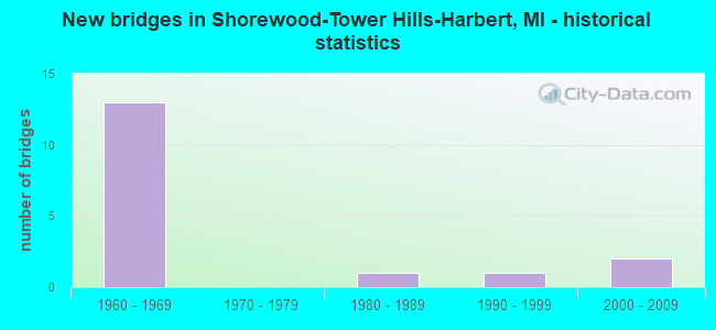
- New bridges - historical statistics
- 131960-1969
- 11980-1989
- 11990-1999
- 22000-2009


- Bridge Condition - Deck
- 57.1%Good
- 42.9%Satisfactory

- Bridge Condition - Superstructure
- 28.6%Very good
- 14.3%Good
- 57.1%Fair

- Bridge Condition - Substructure
- 28.6%Very good
- 28.6%Good
- 42.9%Satisfactory

- Bridge Condition - Channel
- 66.7%Good
- 33.3%Satisfactory
Find on map >> Show street view
Structure Number: 79, Location: 1.0 MI N OF HARBERT (Lat: 41.880025, Lng: -86.601378), Route carried "on" structure: Interstate 94, Year Built: 2003, Status: Open, Structure Length: 5.06m (16.60ft), Average Daily Traffic: 18,325 (year 2007), Truck Traffic: 32%, Average Future Daily Traffic: 25,023 (year 2018), Design Load: HS 25 or greater, Features Intersected: CSX RR
Minimum Vertical Clearance: 30.48m (100.00ft), Kilometerpoint: 18.719, Lanes on structure: 3, Base Highway Network: Yes (Inventory Route: 136, Subroute: 4), Owner: State Highway Agency, Approaching Roadway Width: 15.2m (49.9ft), Skew: 2 degrees, Material/Design: Prestressed concrete, Design/Construction: Box Beam or Girders - Single/Spread, Number Of Spans In Main Unit: 3, Length of Maximum Span: 17.2m (56.4ft), Curb-To-Curb Width: 19.1m (62.7ft), Out-to-Out Width: 19.8m (65.0ft)
Condition: Deck: Good, Superstructure: Very good, Substructure: Good, Operating Rating: 72.4 metric tons, Method Used To Determine Operating Rating: Load Factor (LF), Inventory Rating: 33.3 metric tons, Method Used To Determine Inventory Rating: Load Factor (LF), Structural Evaluation: Better than present minimum criteria, Deck Geometry: Superior to present desirable criteria, Underclear: Equal to present minimum criteria, Approach Roadway Alignment: Better than present minimum criteria, Designated Inspection Frequency: Every 24 months, Inspection Date: August 2020, Deck Structure Type: Concrete Cast-file-Place, Wearing Surface/Protective System: Wearing Surface: Epoxy Overlay, Deck Protection: Epoxy Coated Reinforcing
Find on map >> Show street view
Structure Number: 802, Location: 1.3 MI S OF LAKESIDE (Lat: 41.831278, Lng: -86.668164), Route carried "on" structure: County highway 1113, Year Built: 1962, Status: Open, Structure Length: 9.85m (32.32ft), Average Daily Traffic: 566 (year 2012), Truck Traffic: 3%, Average Future Daily Traffic: 651 (year 2032), Design Load: H 15, Features Intersected: I-94, Facility Carried by Structure: LAKESIDE ROAD
Minimum Vertical Clearance: 30.48m (100.00ft), Kilometerpoint: 7.944, Lanes on structure: 2, Lanes under structure: 7, Owner: State Highway Agency, Approaching Roadway Width: 8.8m (28.9ft), Skew: 3 degrees, Material/Design: Steel, Design/Construction: Stringer/Multi-beam, Number Of Spans In Main Unit: 4, Length of Maximum Span: 31.4m (103.0ft), Curb-To-Curb Width: 8.8m (28.9ft), Out-to-Out Width: 9.9m (32.5ft)
Condition: Deck: Satisfactory, Superstructure: Fair, Substructure: Good, Operating Rating: 55.4 metric tons, Method Used To Determine Operating Rating: Load Factor (LF) rating reported by rating factor (RF) method using MS18 loading, Inventory Rating: 33.4 metric tons, Method Used To Determine Inventory Rating: Load Factor (LF) rating reported by rating factor (RF) method using MS18 loading, Structural Evaluation: Somewhat better than minimum adequacy, Deck Geometry: Somewhat better than minimum adequacy, Underclear: Meets minimum limits, Approach Roadway Alignment: Equal to present desirable criteria, Designated Inspection Frequency: Every 24 months, Inspection Date: October 2020, Deck Structure Type: Concrete Cast-file-Place, Wearing Surface/Protective System: Wearing Surface: Latex Concrete, Deck Protection: Epoxy Coated Reinforcing
Find on map >> Show street view
Structure Number: 803, Location: 1.0 MI SE OF LAKESIDE (Lat: 41.839456, Lng: -86.653314), Route carried "on" structure: County highway 1124, Year Built: 1962, Status: Open, Structure Length: 11.53m (37.83ft), Average Daily Traffic: 1,177 (year 1984), Truck Traffic: 3%, Average Future Daily Traffic: 390 (year 2030), Design Load: H 15, Features Intersected: I-94, Facility Carried by Structure: WARREN WOODS ROAD
Minimum Vertical Clearance: 30.48m (100.00ft), Kilometerpoint: 2.137, Lanes on structure: 2, Lanes under structure: 6, Owner: State Highway Agency, Approaching Roadway Width: 7.3m (24.0ft), Skew: 5 degrees, Material/Design: Steel, Design/Construction: Stringer/Multi-beam, Number Of Spans In Main Unit: 4, Length of Maximum Span: 39.5m (129.6ft), Curb-To-Curb Width: 8.8m (28.9ft), Out-to-Out Width: 9.9m (32.5ft)
Condition: Deck: Satisfactory, Superstructure: Fair, Substructure: Satisfactory, Operating Rating: 63.2 metric tons, Method Used To Determine Operating Rating: Load Factor (LF) rating reported by rating factor (RF) method using MS18 loading, Inventory Rating: 37.9 metric tons, Method Used To Determine Inventory Rating: Load Factor (LF) rating reported by rating factor (RF) method using MS18 loading, Structural Evaluation: Somewhat better than minimum adequacy, Deck Geometry: Somewhat better than minimum adequacy, Underclear: Meets minimum limits, Approach Roadway Alignment: Equal to present desirable criteria, Designated Inspection Frequency: Every 24 months, Inspection Date: October 2020, Deck Structure Type: Concrete Cast-file-Place, Wearing Surface/Protective System: Wearing Surface: Latex Concrete, Deck Protection: Epoxy Coated Reinforcing
Find on map >> Show street view
Structure Number: 804, Location: 1.6 MI E OF LAKESIDE (Lat: 41.849553, Lng: -86.635225), Route carried "on" structure: County highway , Year Built: 1961, Status: Open, Structure Length: 10.40m (34.12ft), Average Daily Traffic: 210 (year 2010), Average Future Daily Traffic: 240 (year 2030), Design Load: H 15, Features Intersected: I-94, Facility Carried by Structure: EAST ROAD
Minimum Vertical Clearance: 30.48m (100.00ft), Kilometerpoint: 2.709, Lanes on structure: 2, Lanes under structure: 6, Owner: State Highway Agency, Approaching Roadway Width: 9.1m (29.9ft), Skew: 5 degrees, Material/Design: Steel, Design/Construction: Stringer/Multi-beam, Number Of Spans In Main Unit: 4, Length of Maximum Span: 35.7m (117.1ft), Curb-To-Curb Width: 8.8m (28.9ft), Out-to-Out Width: 9.9m (32.5ft)
Condition: Deck: Satisfactory, Superstructure: Fair, Substructure: Satisfactory, Operating Rating: 59.9 metric tons, Method Used To Determine Operating Rating: Load Factor (LF) rating reported by rating factor (RF) method using MS18 loading, Inventory Rating: 36.0 metric tons, Method Used To Determine Inventory Rating: Load Factor (LF) rating reported by rating factor (RF) method using MS18 loading, Structural Evaluation: Somewhat better than minimum adequacy, Deck Geometry: Equal to present minimum criteria, Underclear: Meets minimum limits, Approach Roadway Alignment: Better than present minimum criteria, Designated Inspection Frequency: Every 24 months, Inspection Date: October 2020, Deck Structure Type: Concrete Cast-file-Place, Wearing Surface/Protective System: Wearing Surface: Latex Concrete
Find on map >> Show street view
Structure Number: 807, Location: 2.0 MI NE OF HARBERT (Lat: 41.885567, Lng: -86.600872), Route carried "on" structure: Interstate 94, Year Built: 1961, Year Reconstructed: 2006, Status: Open, Structure Length: 4.50m (14.76ft), Average Daily Traffic: 18,373 (year 2007), Truck Traffic: 32%, Average Future Daily Traffic: 24,900 (year 2025), Design Load: HS 20, Features Intersected: SAWYER ROAD
Minimum Vertical Clearance: 30.48m (100.00ft), Kilometerpoint: 19.337, Lanes on structure: 4, Lanes under structure: 4, Base Highway Network: Yes (Inventory Route: 136, Subroute: 4), Owner: State Highway Agency, Approaching Roadway Width: 21.6m (70.9ft), Skew: 1 degrees, Material/Design: Steel, Design/Construction: Stringer/Multi-beam, Number Of Spans In Main Unit: 3, Length of Maximum Span: 19.8m (65.0ft), Curb-To-Curb Width: 20.6m (67.6ft), Out-to-Out Width: 21.6m (70.9ft)
Condition: Deck: Good, Superstructure: Fair, Substructure: Satisfactory, Operating Rating: 84.6 metric tons, Method Used To Determine Operating Rating: Load Factor (LF), Inventory Rating: 50.8 metric tons, Method Used To Determine Inventory Rating: Load Factor (LF), Structural Evaluation: Somewhat better than minimum adequacy, Deck Geometry: Equal to present minimum criteria, Underclear: Equal to present minimum criteria, Approach Roadway Alignment: Equal to present desirable criteria, Designated Inspection Frequency: Every 24 months, Inspection Date: July 2020, Deck Structure Type: Concrete Cast-file-Place, Wearing Surface/Protective System: Wearing Surface: Monolithic Concrete, Deck Protection: Epoxy Coated Reinforcing
Find on map >> Show street view
Structure Number: 962, Location: 3.0 MI NW OF THREE OAKS (Lat: 41.841514, Lng: -86.622136), Route carried "on" structure: County highway 1124, Year Built: 1985, Status: Open, Structure Length: 2.37m (7.78ft), Average Daily Traffic: 1,022 (year 2007), Truck Traffic: 4%, Average Future Daily Traffic: 1,600 (year 2027), Design Load: HS 20, Features Intersected: GALIEN RIVER, Facility Carried by Structure: WARREN WOODS ROAD
Minimum Vertical Clearance: 30+ m (98+ ft), Kilometerpoint: 4.746, Lanes on structure: 2, Owner: County Highway Agency, Approaching Roadway Width: 7.9m (25.9ft), Material/Design: Prestressed concrete, Design/Construction: Stringer/Multi-beam, Number Of Spans In Main Unit: 1, Length of Maximum Span: 23.1m (75.8ft), Curb-To-Curb Width: 10.4m (34.1ft), Out-to-Out Width: 11.1m (36.4ft)
Condition: Deck: Good, Superstructure: Very good, Substructure: Very good, Channel: Satisfactory, Operating Rating: 83.6 metric tons, Method Used To Determine Operating Rating: Load Factor (LF) rating reported by rating factor (RF) method using MS18 loading, Inventory Rating: 50.2 metric tons, Method Used To Determine Inventory Rating: Load Factor (LF) rating reported by rating factor (RF) method using MS18 loading, Structural Evaluation: Equal to present desirable criteria, Deck Geometry: Equal to present minimum criteria, Waterway Adequacy: Superior to present desirable criteria, Approach Roadway Alignment: Equal to present minimum criteria, Designated Inspection Frequency: Every 24 months, Inspection Date: June 2020, Deck Structure Type: Concrete Cast-file-Place, Wearing Surface/Protective System: Wearing Surface: Monolithic Concrete, Deck Protection: Epoxy Coated Reinforcing
Find on map >> Show street view
Structure Number: 13091, Location: LAKE TWP SEC 35 (Lat: 41.899692, Lng: -86.598125), Route carried "on" structure: County highway , Year Built: 1999, Status: Posted for load, Structure Length: 0.67m (2.20ft), Average Daily Traffic: 360 (year 2007), Truck Traffic: 5%, Average Future Daily Traffic: 500 (year 2027), Design Load: HS 20, Features Intersected: CLYMER COUNTY DRAIN, Facility Carried by Structure: BROWNTOWN ROAD
Minimum Vertical Clearance: 30.48m (100.00ft), Kilometerpoint: 0.921, Lanes on structure: 2, Base Highway Network: Yes (Inventory Route: 137, Subroute: 9), Owner: County Highway Agency, Approaching Roadway Width: 6.7m (22.0ft), Material/Design: Wood or Timber, Design/Construction: Slab, Number Of Spans In Main Unit: 1, Length of Maximum Span: 6.1m (20.0ft), Curb-To-Curb Width: 9.1m (29.9ft), Out-to-Out Width: 9.6m (31.5ft)
Condition: Deck: Good, Superstructure: Good, Substructure: Very good, Channel: Good, Operating Rating: 33.7 metric tons, Method Used To Determine Operating Rating: Allowable Stress (AS) rating reported by rating factor (RF) method using MS18 loading, Inventory Rating: 23.3 metric tons, Method Used To Determine Inventory Rating: Allowable Stress (AS) rating reported by rating factor (RF) method using MS18 loading, Structural Evaluation: Equal to present minimum criteria, Deck Geometry: Equal to present minimum criteria, Waterway Adequacy: Better than present minimum criteria, Approach Roadway Alignment: Equal to present minimum criteria, Bridge Posting: Required (Relationship of Operating Rating to Maximum Legal Load: 10.0 - 19.9% below), Length Of Structure Improvement: 1.16m (3.81ft), Designated Inspection Frequency: Every 24 months, Inspection Date: July 2020, Bridge Improvement Cost: $133,000, Roadway Improvement Cost: $45,000, Total Project Cost: $178,000, Deck Structure Type: Wood or Timber, Wearing Surface/Protective System: Wearing Surface: Bituminous
Find on map >> Show street view
Structure Number: 1349, Location: LAKE TWP SEC 35 (Lat: 41.900089, Lng: -86.606114), Route carried "on" structure: Federal lands road , Year Built: 2009, Status: Open, Structure Length: 0.91m (2.99ft), Average Daily Traffic: 150 (year 2009), Truck Traffic: 2%, Average Future Daily Traffic: 250 (year 2029), Features Intersected: PAINTERVILLE CREEK, Facility Carried by Structure: WARREN DUNES ST PK
Minimum Vertical Clearance: 30.48m (100.00ft), Kilometerpoint: 1.036, Lanes on structure: 2, Owner: State Park, Forest, or Reservation Agency, Approaching Roadway Width: 6.6m (21.7ft), Material/Design: Concrete, Design/Construction: Culvert, Number Of Spans In Main Unit: 1, Length of Maximum Span: 8.5m (27.9ft), Curb-To-Curb Width: 19.2m (63.0ft), Out-to-Out Width: 20.3m (66.6ft)
Condition: Channel: Good, Culverts: Satisfactory, Operating Rating: 97.2 metric tons, Method Used To Determine Operating Rating: Load and Resistance Factor Rating (LRFR) rating reported by rating factor(RF) method using HL-93 loadings, Inventory Rating: 97.2 metric tons, Method Used To Determine Inventory Rating: Load and Resistance Factor Rating (LRFR) rating reported by rating factor(RF) method using HL-93 loadings, Structural Evaluation: Equal to present minimum criteria, Deck Geometry: Superior to present desirable criteria, Waterway Adequacy: Better than present minimum criteria, Approach Roadway Alignment: Better than present minimum criteria, Designated Inspection Frequency: Every 24 months, Inspection Date: October 2021, Wearing Surface/Protective System: Wearing Surface: Bituminous
Find on map >> Show street view
Structure Number: 801, Location: 0.9 MI E OF UNION PIER (Lat: 41.827967, Lng: -86.673478), Route carried "under" structure: Interstate 94, Year Built: 1962, Structure Length: 0. m, Average Daily Traffic: 42,600 (year 2016), Truck Traffic: 32%, Features Intersected: I-94, Facility Carried by Structure: UNION PIER ROAD
Minimum Vertical Clearance: 4.90m (16.08ft), Kilometerpoint: 10.030, Lanes on structure: 2, Lanes under structure: 6, Material/Design: Steel, Design/Construction: Stringer/Multi-beam, Length of Maximum Span: 35.4m (116.1ft)
Find on map >> Show street view
Structure Number: 802, Location: 1.3 MI S OF LAKESIDE (Lat: 41.831278, Lng: -86.668164), Route carried "under" structure: Interstate 94, Year Built: 1962, Structure Length: 0. m, Average Daily Traffic: 42,300 (year 2016), Truck Traffic: 32%, Features Intersected: I-94, Facility Carried by Structure: LAKESIDE ROAD
Minimum Vertical Clearance: 5.16m (16.93ft), Kilometerpoint: 10.585, Lanes on structure: 2, Lanes under structure: 7, Material/Design: Steel, Design/Construction: Stringer/Multi-beam, Length of Maximum Span: 31.4m (103.0ft)
Find on map >> Show street view
Structure Number: 803, Location: 1.0 MI SE OF LAKESIDE (Lat: 41.839456, Lng: -86.653314), Route carried "under" structure: Interstate 94, Year Built: 1962, Structure Length: 0. m, Average Daily Traffic: 36,200 (year 2010), Truck Traffic: 37%, Features Intersected: I-94, Facility Carried by Structure: WARREN WOODS ROAD
Minimum Vertical Clearance: 5.36m (17.59ft), Kilometerpoint: 12.136, Lanes on structure: 2, Lanes under structure: 6, Material/Design: Steel, Design/Construction: Stringer/Multi-beam, Length of Maximum Span: 39.5m (129.6ft)
Find on map >> Show street view
Structure Number: 804, Location: 1.6 MI E OF LAKESIDE (Lat: 41.849553, Lng: -86.635225), Route carried "under" structure: Interstate 94, Year Built: 1961, Structure Length: 0. m, Average Daily Traffic: 36,200 (year 2010), Truck Traffic: 37%, Features Intersected: I-94, Facility Carried by Structure: EAST ROAD
Minimum Vertical Clearance: 5.13m (16.83ft), Kilometerpoint: 14.011, Lanes on structure: 2, Lanes under structure: 6, Material/Design: Steel, Design/Construction: Stringer/Multi-beam, Length of Maximum Span: 35.7m (117.1ft)
Find on map >> Show street view
Structure Number: 805, Location: 1.5 MI SE OF HARBERT (Lat: 41.863756, Lng: -86.609675), Route carried "under" structure: Interstate 94, Year Built: 1960, Structure Length: 0. m, Average Daily Traffic: 36,650 (year 2007), Truck Traffic: 32%, Features Intersected: I-94, Facility Carried by Structure: THREE OAKS ROAD
Minimum Vertical Clearance: 5.08m (16.67ft), Kilometerpoint: 16.656, Lanes on structure: 2, Lanes under structure: 6, Material/Design: Steel, Design/Construction: Stringer/Multi-beam, Length of Maximum Span: 26.8m (87.9ft)
Find on map >> Show street view
Structure Number: 806, Location: 1.5 MI E OF HARBERT (Lat: 41.871097, Lng: -86.601869), Route carried "under" structure: Interstate 94, Year Built: 1961, Structure Length: 0. m, Average Daily Traffic: 35,300 (year 2011), Truck Traffic: 30%, Features Intersected: I-94, Facility Carried by Structure: HARBERT ROAD
Minimum Vertical Clearance: 5.64m (18.50ft), Kilometerpoint: 17.724, Lanes on structure: 2, Lanes under structure: 6, Material/Design: Steel, Design/Construction: Stringer/Multi-beam, Length of Maximum Span: 21.9m (71.9ft)
Find on map >> Show street view
Structure Number: 807, Location: 2.0 MI NE OF HARBERT (Lat: 41.885567, Lng: -86.600872), Route carried "under" structure: County highway 1130, Year Built: 1961, Structure Length: 0. m, Average Daily Traffic: 6,323 (year 1992), Truck Traffic: 3%, Features Intersected: SAWYER ROAD, Facility Carried by Structure: I-94 EB
Minimum Vertical Clearance: 5.28m (17.32ft), Kilometerpoint: 2.635, Lanes on structure: 4, Lanes under structure: 4, Material/Design: Steel, Design/Construction: Stringer/Multi-beam, Length of Maximum Span: 19.8m (65.0ft)
Find on map >> Show street view
Structure Number: 808, Location: 2.0 MI NE OF HARBERT (Lat: 41.885564, Lng: -86.601236), Route carried "under" structure: County highway 1130, Year Built: 1961, Structure Length: 0. m, Average Daily Traffic: 6,323 (year 1992), Truck Traffic: 3%, Features Intersected: SAWYER ROAD, Facility Carried by Structure: I-94 WB
Minimum Vertical Clearance: 4.50m (14.76ft), Kilometerpoint: 2.604, Lanes on structure: 4, Lanes under structure: 4, Material/Design: Steel, Design/Construction: Stringer/Multi-beam, Length of Maximum Span: 19.8m (65.0ft)
Find on map >> Show street view
Structure Number: 809, Location: 2.0 MI S OF BRIDGEMAN (Lat: 41.899636, Lng: -86.589417), Route carried "under" structure: Interstate 94, Year Built: 1961, Structure Length: 0. m, Average Daily Traffic: 36,746 (year 2007), Truck Traffic: 31%, Features Intersected: I-94, Facility Carried by Structure: BROWNTOWN ROAD
Minimum Vertical Clearance: 5.05m (16.57ft), Kilometerpoint: 21.172, Lanes on structure: 2, Lanes under structure: 6, Material/Design: Steel, Design/Construction: Stringer/Multi-beam, Length of Maximum Span: 25.6m (84.0ft)