Bridge Statistics for Shoshone, Idaho (ID)
Condition, Traffic, Stress, Structural Evaluation, Project Costs
- National Bridge Inventory (NBI) Statistics
- 11Number of bridges
- 79ft / 24.0mTotal length
- $3,569,000Total costs
- 20,030Total average daily traffic
- 2,368Total average daily truck traffic
- 30,045Total future (year 2039) average daily traffic
- National Bridge Inventory (NBI) Registered Bridges for Shoshone
- No street view available for this location
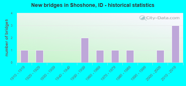
- New bridges - historical statistics
- 11910-1919
- 11920-1929
- 21950-1959
- 11960-1969
- 11970-1979
- 11980-1989
- 12000-2009
- 32010-2019

- Reconstructed bridges - Historical Statistics
- 11970-1979
- 01980-1989
- 11990-1999
- 12000-2009


- Bridge Condition - Deck
- 9.1%Very good
- 36.4%Good
- 36.4%Satisfactory
- 18.2%Fair

- Bridge Condition - Superstructure
- 18.2%Very good
- 18.2%Good
- 36.4%Satisfactory
- 9.1%Fair
- 18.2%Poor

- Bridge Condition - Substructure
- 9.1%Very good
- 27.3%Good
- 45.5%Satisfactory
- 18.2%Fair

- Bridge Condition - Channel
- 18.2%Excellent
- 45.5%Very good
- 27.3%Good
- 9.1%Fair
Find on map >> Show street view
Structure Number: 13026, Location: 2.5 E. SHOSHONE (Lat: 42.917250, Lng: -114.366639), Route carried "on" structure: State highway 24, Year Built: 2007, Status: Open, Structure Length: 2.32m (7.61ft), Average Daily Traffic: 1,600 (year 2019), Truck Traffic: 13%, Average Future Daily Traffic: 2,400 (year 2039), Design Load: HL 93, Features Intersected: MILNER GOODING CANAL
Minimum Vertical Clearance: 30+ m (98+ ft), Kilometerpoint: 104.800, Lanes on structure: 2, Owner: State Highway Agency, Approaching Roadway Width: 11.9m (39.0ft), Material/Design: Concrete, Design/Construction: Frame, Number Of Spans In Main Unit: 3, Length of Maximum Span: 7.3m (24.0ft), Curb-To-Curb Width: 12.0m (39.4ft), Out-to-Out Width: 12.8m (42.0ft)
Condition: Deck: Satisfactory, Superstructure: Satisfactory, Substructure: Satisfactory, Channel: Good, Operating Rating: 88.9 metric tons, Method Used To Determine Operating Rating: Load Factor (LF), Inventory Rating: 53.5 metric tons, Method Used To Determine Inventory Rating: Load Factor (LF), Structural Evaluation: Equal to present minimum criteria, Deck Geometry: Equal to present minimum criteria, Waterway Adequacy: Superior to present desirable criteria, Approach Roadway Alignment: Equal to present desirable criteria, Designated Inspection Frequency: Every 48 months, Inspection Date: April 2021, Deck Structure Type: Concrete Cast-file-Place, Wearing Surface/Protective System: Deck Protection: Epoxy Coated Reinforcing
Find on map >> Show street view
Structure Number: 1315, Location: 1.6 E. SHOSHONE (Lat: 42.938056, Lng: -114.376111), Route carried "on" structure: US 93, Year Built: 1987, Status: Open, Structure Length: 2.32m (7.61ft), Average Daily Traffic: 2,400 (year 2019), Truck Traffic: 13%, Average Future Daily Traffic: 3,600 (year 2039), Design Load: HS 20, Features Intersected: MILNER GOODING CANAL
Minimum Vertical Clearance: 30+ m (98+ ft), Kilometerpoint: 269.626, Lanes on structure: 2, Base Highway Network: Yes (Inventory Route: US0, Subroute: 2), Owner: State Highway Agency, Approaching Roadway Width: 10.4m (34.1ft), Material/Design: Concrete continuous, Design/Construction: Slab, Number Of Spans In Main Unit: 2, Length of Maximum Span: 11.3m (37.1ft), Curb-To-Curb Width: 11.1m (36.4ft), Out-to-Out Width: 12.0m (39.4ft)
Condition: Deck: Satisfactory, Superstructure: Satisfactory, Substructure: Satisfactory, Channel: Very good, Operating Rating: 60.8 metric tons, Method Used To Determine Operating Rating: Load Factor (LF), Inventory Rating: 36.3 metric tons, Method Used To Determine Inventory Rating: Load Factor (LF), Structural Evaluation: Equal to present minimum criteria, Deck Geometry: Somewhat better than minimum adequacy, Waterway Adequacy: Equal to present desirable criteria, Approach Roadway Alignment: Equal to present desirable criteria, Designated Inspection Frequency: Every 48 months, Inspection Date: April 2020, Deck Structure Type: Concrete Cast-file-Place, Wearing Surface/Protective System: Wearing Surface: Epoxy Overlay, Deck Protection: Epoxy Coated Reinforcing
Find on map >> Show street view
Structure Number: 17615, Location: AT SHOSHONE NCL (Lat: 42.937111, Lng: -114.405611), Route carried "on" structure: State highway 75, Year Built: 1958, Status: Open, Structure Length: 1.10m (3.61ft), Average Daily Traffic: 5,900 (year 2019), Truck Traffic: 10%, Average Future Daily Traffic: 8,850 (year 2039), Design Load: HS 20, Features Intersected: LITTLE WOOD RIVER
Minimum Vertical Clearance: 30+ m (98+ ft), Kilometerpoint: 118.682, Lanes on structure: 4, Base Highway Network: Yes, Owner: State Highway Agency, Approaching Roadway Width: 19.5m (64.0ft), Material/Design: Concrete, Design/Construction: Tee Beam, Number Of Spans In Main Unit: 1, Length of Maximum Span: 10.7m (35.1ft), Curb or Sidewalk Widths: Left: 1.5m (4.9ft), Right: 1.5m (4.9ft), Curb-To-Curb Width: 19.5m (64.0ft), Out-to-Out Width: 23.2m (76.1ft)
Condition: Deck: Good, Superstructure: Good, Substructure: Good, Channel: Very good, Operating Rating: 60.8 metric tons, Method Used To Determine Operating Rating: Load Factor (LF), Inventory Rating: 36.3 metric tons, Method Used To Determine Inventory Rating: Load Factor (LF), Structural Evaluation: Better than present minimum criteria, Deck Geometry: Better than present minimum criteria, Waterway Adequacy: Equal to present minimum criteria, Approach Roadway Alignment: Equal to present desirable criteria, Designated Inspection Frequency: Every 48 months, Underwater Inspection Frequency: Every 60 months, Inspection Date: July 2019, Underwater Inspection Date: August 2019, Deck Structure Type: Concrete Cast-file-Place, Wearing Surface/Protective System: Wearing Surface: Bituminous
Find on map >> Show street view
Structure Number: 17621, Location: 1.4 N. SHOSHONE (Lat: 42.962417, Lng: -114.402194), Route carried "on" structure: State highway 75, Year Built: 2013, Status: Open, Structure Length: 1.04m (3.41ft), Average Daily Traffic: 4,300 (year 2019), Truck Traffic: 12%, Average Future Daily Traffic: 6,450 (year 2039), Design Load: HL 93, Features Intersected: MILNER GOODING CANAL
Minimum Vertical Clearance: 30+ m (98+ ft), Kilometerpoint: 121.515, Lanes on structure: 2, Base Highway Network: Yes, Owner: State Highway Agency, Approaching Roadway Width: 11.3m (37.1ft), Material/Design: Prestressed concrete, Design/Construction: Box Beam or Girders - Multiple, Number Of Spans In Main Unit: 1, Length of Maximum Span: 10.1m (33.1ft), Curb-To-Curb Width: 11.4m (37.4ft), Out-to-Out Width: 12.2m (40.0ft)
Condition: Deck: Very good, Superstructure: Very good, Substructure: Good, Channel: Excellent, Operating Rating: 68.0 metric tons, Method Used To Determine Operating Rating: Load Factor (LF), Inventory Rating: 39.0 metric tons, Method Used To Determine Inventory Rating: Load Factor (LF), Structural Evaluation: Better than present minimum criteria, Deck Geometry: Somewhat better than minimum adequacy, Waterway Adequacy: Superior to present desirable criteria, Approach Roadway Alignment: Equal to present desirable criteria, Designated Inspection Frequency: Every 48 months, Inspection Date: July 2019, Deck Structure Type: Concrete Precast Panels, Wearing Surface/Protective System: Wearing Surface: Bituminous, Membrane: Other, Deck Protection: Epoxy Coated Reinforcing
Find on map >> Show street view
Structure Number: 17626, Location: 3.0 N. SHOSHONE (Lat: 42.983639, Lng: -114.395083), Route carried "on" structure: State highway 75, Year Built: 2013, Status: Open, Structure Length: 5.09m (16.70ft), Average Daily Traffic: 4,300 (year 2019), Truck Traffic: 12%, Average Future Daily Traffic: 6,450 (year 2039), Design Load: HL 93, Features Intersected: BIG WOOD RIVER
Minimum Vertical Clearance: 30+ m (98+ ft), Kilometerpoint: 123.916, Lanes on structure: 2, Base Highway Network: Yes, Owner: State Highway Agency, Approaching Roadway Width: 11.3m (37.1ft), Skew: 3 degrees, Material/Design: Prestressed concrete, Design/Construction: Stringer/Multi-beam, Number Of Spans In Main Unit: 2, Length of Maximum Span: 24.4m (80.1ft), Curb-To-Curb Width: 11.4m (37.4ft), Out-to-Out Width: 12.2m (40.0ft)
Condition: Deck: Good, Superstructure: Very good, Substructure: Good, Channel: Excellent, Operating Rating: 67.1 metric tons, Method Used To Determine Operating Rating: Load Factor (LF), Inventory Rating: 40.8 metric tons, Method Used To Determine Inventory Rating: Load Factor (LF), Structural Evaluation: Better than present minimum criteria, Deck Geometry: Somewhat better than minimum adequacy, Waterway Adequacy: Superior to present desirable criteria, Approach Roadway Alignment: Equal to present desirable criteria, Designated Inspection Frequency: Every 48 months, Inspection Date: July 2019, Deck Structure Type: Concrete Cast-file-Place, Wearing Surface/Protective System: Wearing Surface: Low Slump Concrete, Deck Protection: Epoxy Coated Reinforcing
Find on map >> Show street view
Structure Number: 24905, Location: IN SHOSHONE;N.APPLE ST (Lat: 42.936694, Lng: -114.406889), Route carried "on" structure: City street , Year Built: 1920, Year Reconstructed: 2001, Status: Open, Structure Length: 1.37m (4.49ft), Average Daily Traffic: 200 (year 2019), Truck Traffic: 5%, Average Future Daily Traffic: 300 (year 2039), Design Load: H 10, Features Intersected: LITTLE WOOD RIVER, Facility Carried by Structure: NORTH APPLE STREET
Minimum Vertical Clearance: 30+ m (98+ ft), Kilometerpoint: 160.982, Lanes on structure: 1, Owner: City or Municipal Highway Agency, Approaching Roadway Width: 6.1m (20.0ft), Material/Design: Steel, Design/Construction: Girder and Floorbeam System, Number Of Spans In Main Unit: 1, Length of Maximum Span: 13.4m (44.0ft), Curb or Sidewalk Widths: Left: 1.2m (3.9ft), Right: 0.0m, Curb-To-Curb Width: 5.0m (16.4ft), Out-to-Out Width: 5.2m (17.1ft)
Condition: Deck: Good, Superstructure: Fair, Substructure: Fair, Channel: Fair, Operating Rating: 49.9 metric tons, Method Used To Determine Operating Rating: Load Factor (LF), Inventory Rating: 29.9 metric tons, Method Used To Determine Inventory Rating: Load Factor (LF), Structural Evaluation: Somewhat better than minimum adequacy, Deck Geometry: High priority of replacement, Waterway Adequacy: Equal to present desirable criteria, Approach Roadway Alignment: Better than present minimum criteria, Length Of Structure Improvement: 2.01m (6.59ft), Designated Inspection Frequency: Every 24 months, Critical Feature Inspection Frequency: Every 24 months, Inspection Date: October 2020, Critical Feature Inspection Date: October 2020, Bridge Improvement Cost: $381,000, Roadway Improvement Cost: $38,000, Total Project Cost: $572,000 ( Estimate for 2016), Deck Structure Type: Wood or Timber, Wearing Surface/Protective System: Wearing Surface: Bituminous
Find on map >> Show street view
Structure Number: 2491, Location: IN SHOSHONE;N.BIRCH ST (Lat: 42.937694, Lng: -114.408083), Route carried "on" structure: City street , Year Built: 1913, Year Reconstructed: 2000, Status: Posted for load, Structure Length: 1.92m (6.30ft), Average Daily Traffic: 200 (year 2019), Truck Traffic: 5%, Average Future Daily Traffic: 300 (year 2039), Design Load: H 15, Features Intersected: LITTLE WOOD RIVER, Facility Carried by Structure: NORTH BIRCH STREET
Minimum Vertical Clearance: 30+ m (98+ ft), Kilometerpoint: 161.056, Lanes on structure: 1, Owner: City or Municipal Highway Agency, Approaching Roadway Width: 5.5m (18.0ft), Material/Design: Steel, Design/Construction: Truss - Thru, Number Of Spans In Main Unit: 1, Length of Maximum Span: 18.3m (60.0ft), Curb or Sidewalk Widths: Left: 0.0m, Right: 1.2m (3.9ft), Curb-To-Curb Width: 4.8m (15.7ft), Out-to-Out Width: 4.9m (16.1ft)
Condition: Deck: Satisfactory, Superstructure: Poor, Substructure: Satisfactory, Channel: Good, Operating Rating: 25.4 metric tons, Method Used To Determine Operating Rating: Load Factor (LF), Inventory Rating: 15.4 metric tons, Method Used To Determine Inventory Rating: Load Factor (LF), Structural Evaluation: Meets minimum limits, Deck Geometry: High priority of corrective action, Waterway Adequacy: Equal to present desirable criteria, Approach Roadway Alignment: High priority of corrective action, Bridge Posting: Required (Relationship of Operating Rating to Maximum Legal Load: 20.0 - 29.9% below), Length Of Structure Improvement: 2.62m (8.60ft), Designated Inspection Frequency: Every 12 months, Critical Feature Inspection Frequency: Every 12 months, Inspection Date: October 2021, Critical Feature Inspection Date: October 2021, Bridge Improvement Cost: $497,000, Roadway Improvement Cost: $48,000, Total Project Cost: $746,000 ( Estimate for 2016), Deck Structure Type: Wood or Timber, Wearing Surface/Protective System: Wearing Surface: Bituminous
Find on map >> Show street view
Structure Number: 24916, Location: IN SHOSHONE; N. GRAPE ST (Lat: 42.939972, Lng: -114.415139), Route carried "on" structure: City street , Year Built: 2016, Status: Open, Structure Length: 2.56m (8.40ft), Average Daily Traffic: 100 (year 2019), Truck Traffic: 5%, Average Future Daily Traffic: 150 (year 2039), Design Load: HL 93, Features Intersected: LITTLE WOOD RIVER, Facility Carried by Structure: NORTH GRAPE STREET
Minimum Vertical Clearance: 30+ m (98+ ft), Kilometerpoint: 161.107, Lanes on structure: 2, Owner: City or Municipal Highway Agency, Approaching Roadway Width: 7.6m (24.9ft), Material/Design: Prestressed concrete, Design/Construction: Stringer/Multi-beam, Number Of Spans In Main Unit: 1, Length of Maximum Span: 25.0m (82.0ft), Curb or Sidewalk Widths: Left: 0.2m (0.7ft), Right: 0.2m (0.7ft), Curb-To-Curb Width: 9.3m (30.5ft), Out-to-Out Width: 9.8m (32.2ft)
Condition: Deck: Good, Superstructure: Good, Substructure: Very good, Channel: Very good, Operating Rating: 50.9 metric tons, Method Used To Determine Operating Rating: Load and Resistance Factor Rating (LRFR) rating reported by rating factor(RF) method using HL-93 loadings, Inventory Rating: 39.2 metric tons, Method Used To Determine Inventory Rating: Load and Resistance Factor Rating (LRFR) rating reported by rating factor(RF) method using HL-93 loadings, Structural Evaluation: Better than present minimum criteria, Deck Geometry: Better than present minimum criteria, Waterway Adequacy: Equal to present desirable criteria, Approach Roadway Alignment: Equal to present desirable criteria, Designated Inspection Frequency: Every 48 months, Inspection Date: October 2018, Deck Structure Type: Concrete Precast Panels, Wearing Surface/Protective System: Wearing Surface: Bituminous, Membrane: Epoxy, Deck Protection: Epoxy Coated Reinforcing
Find on map >> Show street view
Structure Number: 24965, Location: 0.3 S. 1.8 E. SHOSHONE (Lat: 42.930333, Lng: -114.374306), Route carried "on" structure: County highway , Year Built: 1977, Status: Posted for load, Structure Length: 2.41m (7.91ft), Average Daily Traffic: 20 (year 2019), Truck Traffic: 10%, Average Future Daily Traffic: 30 (year 2039), Design Load: HS 20, Features Intersected: MILNER GOODING CANAL, Facility Carried by Structure: 30 SOUTH ROAD
Minimum Vertical Clearance: 30+ m (98+ ft), Kilometerpoint: 161.929, Lanes on structure: 1, Owner: Local Agency, Approaching Roadway Width: 4.9m (16.1ft), Skew: 2 degrees, Material/Design: Steel, Design/Construction: Stringer/Multi-beam, Number Of Spans In Main Unit: 4, Length of Maximum Span: 6.1m (20.0ft), Curb-To-Curb Width: 4.8m (15.7ft), Out-to-Out Width: 5.0m (16.4ft)
Condition: Deck: Fair, Superstructure: Satisfactory, Substructure: Fair, Channel: Very good, Operating Rating: 43.5 metric tons, Method Used To Determine Operating Rating: Load Factor (LF), Inventory Rating: 26.3 metric tons, Method Used To Determine Inventory Rating: Load Factor (LF), Structural Evaluation: Somewhat better than minimum adequacy, Deck Geometry: Equal to present desirable criteria, Waterway Adequacy: Better than present minimum criteria, Approach Roadway Alignment: Better than present minimum criteria, Length Of Structure Improvement: 3.11m (10.20ft), Designated Inspection Frequency: Every 24 months, Inspection Date: March 2021, Bridge Improvement Cost: $471,000, Roadway Improvement Cost: $47,000, Total Project Cost: $706,000 ( Estimate for 2017), Deck Structure Type: Concrete Cast-file-Place, Wearing Surface/Protective System: Wearing Surface: Gravel
Find on map >> Show street view
Structure Number: 25105, Location: 1.5 S. 2.6 E. SHOSHONE (Lat: 42.915917, Lng: -114.354194), Route carried "on" structure: County highway 2784, Year Built: 1955, Year Reconstructed: 1977, Status: Open, Structure Length: 2.38m (7.81ft), Average Daily Traffic: 180 (year 2019), Average Future Daily Traffic: 270 (year 2039), Design Load: HS 20, Features Intersected: MILNER GOODING CANAL
Minimum Vertical Clearance: 30+ m (98+ ft), Kilometerpoint: 160.955, Lanes on structure: 2, Owner: Local Agency, Approaching Roadway Width: 6.7m (22.0ft), Material/Design: Steel continuous, Design/Construction: Stringer/Multi-beam, Number Of Spans In Main Unit: 4, Length of Maximum Span: 5.8m (19.0ft), Curb-To-Curb Width: 8.2m (26.9ft), Out-to-Out Width: 8.2m (26.9ft)
Condition: Deck: Fair, Superstructure: Poor, Substructure: Satisfactory, Channel: Good, Operating Rating: 47.2 metric tons, Method Used To Determine Operating Rating: Load Factor (LF), Inventory Rating: 28.1 metric tons, Method Used To Determine Inventory Rating: Load Factor (LF), Structural Evaluation: Meets minimum limits, Deck Geometry: Somewhat better than minimum adequacy, Waterway Adequacy: Equal to present desirable criteria, Approach Roadway Alignment: Equal to present desirable criteria, Length Of Structure Improvement: 3.14m (10.30ft), Designated Inspection Frequency: Every 12 months, Inspection Date: March 2021, Bridge Improvement Cost: $510,000, Roadway Improvement Cost: $51,000, Total Project Cost: $765,000 ( Estimate for 2019), Deck Structure Type: Closed Grating, Wearing Surface/Protective System: Wearing Surface: Bituminous
Find on map >> Show street view
Structure Number: 25115, Location: 4.3 N. 2.3 W. SHOSHONE (Lat: 42.996472, Lng: -114.441333), Route carried "on" structure: County highway 2781, Year Built: 1965, Status: Open, Structure Length: 1.52m (4.99ft), Average Daily Traffic: 830 (year 2019), Truck Traffic: 24%, Average Future Daily Traffic: 1,245 (year 2039), Design Load: H 20, Features Intersected: MILNER GOODING CANAL
Minimum Vertical Clearance: 30+ m (98+ ft), Kilometerpoint: 21.430, Lanes on structure: 2, Owner: Local Agency, Approaching Roadway Width: 7.3m (24.0ft), Skew: 2 degrees, Material/Design: Concrete continuous, Design/Construction: Frame, Number Of Spans In Main Unit: 3, Length of Maximum Span: 4.9m (16.1ft), Curb or Sidewalk Widths: Left: 0.3m (1.0ft), Right: 0.3m (1.0ft), Curb-To-Curb Width: 8.5m (27.9ft), Out-to-Out Width: 9.3m (30.5ft)
Condition: Deck: Satisfactory, Superstructure: Satisfactory, Substructure: Satisfactory, Channel: Very good, Operating Rating: 32.7 metric tons, Method Used To Determine Operating Rating: Load Factor (LF), Inventory Rating: 19.1 metric tons, Method Used To Determine Inventory Rating: Load Factor (LF), Structural Evaluation: Somewhat better than minimum adequacy, Deck Geometry: Somewhat better than minimum adequacy, Waterway Adequacy: Equal to present desirable criteria, Approach Roadway Alignment: Better than present minimum criteria, Length Of Structure Improvement: 2.29m (7.51ft), Designated Inspection Frequency: Every 24 months, Inspection Date: March 2021, Bridge Improvement Cost: $520,000, Roadway Improvement Cost: $52,000, Total Project Cost: $780,000 ( Estimate for 2017), Deck Structure Type: Concrete Cast-file-Place, Wearing Surface/Protective System: Wearing Surface: Bituminous