Bridge Statistics for Sigurd, Utah (UT)
Condition, Traffic, Stress, Structural Evaluation, Project Costs
- National Bridge Inventory (NBI) Statistics
- 26Number of bridges
- 243ft / 74.0mTotal length
- 131,156Total average daily traffic
- 45,951Total average daily truck traffic
- National Bridge Inventory (NBI) Registered Bridges for Sigurd
- No street view available for this location
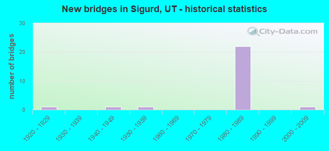
- New bridges - historical statistics
- 11920-1929
- 11940-1949
- 11950-1959
- 221980-1989
- 12000-2009

- Reconstructed bridges - Historical Statistics
- 11960-1969
- 11970-1979
- 01980-1989
- 01990-1999
- 12000-2009


- Bridge Condition - Deck
- 54.5%Good
- 45.5%Satisfactory

- Bridge Condition - Superstructure
- 18.2%Very good
- 72.7%Good
- 9.1%Fair

- Bridge Condition - Substructure
- 27.3%Good
- 72.7%Satisfactory

- Bridge Condition - Channel
- 25.0%Very good
- 58.3%Good
- 16.7%Satisfactory

- Bridge Condition - Culverts
- 14.3%Very good
- 85.7%Satisfactory
Find on map >> Show street view
Structure Number: 41021E, Location: 1 MILE NORTH OF VENICE (Lat: 38.814053, Lng: -112.006581), Route carried "on" structure: County highway 2541, Year Built: 1947, Year Reconstructed: 2009, Status: Open, Structure Length: 0.71m (2.33ft), Average Daily Traffic: 970 (year 2020), Truck Traffic: 4%, Average Future Daily Traffic: 1,213 (year 2040), Design Load: H 15, Features Intersected: VERMILLION CANAL, Facility Carried by Structure: COUNTY ROAD
Minimum Vertical Clearance: 30+ m (98+ ft), Kilometerpoint: 1.358, Lanes on structure: 2, Owner: County Highway Agency, Approaching Roadway Width: 7.9m (25.9ft), Skew: 4 degrees, Material/Design: Concrete, Design/Construction: Culvert, Number Of Spans In Main Unit: 1, Length of Maximum Span: 6.2m (20.3ft), Curb-To-Curb Width: 7.9m (25.9ft), Out-to-Out Width: 15.2m (49.9ft)
Condition: Channel: Good, Culverts: Very good, Operating Rating: 40.2 metric tons, Method Used To Determine Operating Rating: Load and Resistance Factor Rating (LRFR) rating reported by rating factor(RF) method using HL-93 loadings, Inventory Rating: 19.8 metric tons, Method Used To Determine Inventory Rating: Load Factor (LF) rating reported by rating factor (RF) method using MS18 loading, Structural Evaluation: Somewhat better than minimum adequacy, Deck Geometry: Somewhat better than minimum adequacy, Waterway Adequacy: Equal to present minimum criteria, Approach Roadway Alignment: Equal to present desirable criteria, Designated Inspection Frequency: Every 22 months, Inspection Date: July 2020
Find on map >> Show street view
Structure Number: 41024F, Location: 3.5 MILES SOUTH OF AURORA (Lat: 38.872728, Lng: -111.954308), Route carried "on" structure: County highway , Year Built: 2006, Status: Open, Structure Length: 1.86m (6.10ft), Average Daily Traffic: 252 (year 2020), Truck Traffic: 5%, Average Future Daily Traffic: 306 (year 2040), Design Load: HL 93, Features Intersected: SEVIER RIVER, Facility Carried by Structure: COUNTY ROAD
Minimum Vertical Clearance: 30+ m (98+ ft), Kilometerpoint: 0.568, Lanes on structure: 2, Owner: County Highway Agency, Approaching Roadway Width: 9.8m (32.2ft), Material/Design: Prestressed concrete, Design/Construction: Stringer/Multi-beam, Number Of Spans In Main Unit: 1, Length of Maximum Span: 17.8m (58.4ft), Curb-To-Curb Width: 9.8m (32.2ft), Out-to-Out Width: 10.7m (35.1ft)
Condition: Deck: Good, Superstructure: Very good, Substructure: Good, Channel: Very good, Operating Rating: 53.8 metric tons, Method Used To Determine Operating Rating: Load and Resistance Factor Rating (LRFR) rating reported by rating factor(RF) method using HL-93 loadings, Inventory Rating: 44.7 metric tons, Method Used To Determine Inventory Rating: Load Factor (LF) rating reported by rating factor (RF) method using MS18 loading, Structural Evaluation: Better than present minimum criteria, Deck Geometry: Better than present minimum criteria, Waterway Adequacy: Equal to present desirable criteria, Approach Roadway Alignment: Equal to present desirable criteria, Designated Inspection Frequency: Every 22 months, Inspection Date: July 2020, Deck Structure Type: Concrete Cast-file-Place, Wearing Surface/Protective System: Wearing Surface: Monolithic Concrete, Deck Protection: Epoxy Coated Reinforcing
Find on map >> Show street view
Structure Number: C 748, Location: 5.8 MI.N.NO.RICHFIELD INT (Lat: 38.847714, Lng: -112.007178), Route carried "on" structure: County highway , Year Built: 1989, Status: Open, Structure Length: 10.16m (33.33ft), Average Daily Traffic: 500 (year 2020), Average Future Daily Traffic: 1,000 (year 2040), Design Load: HS 20+Mod, Features Intersected: I-70 (SR-70) EBL & WBL, Facility Carried by Structure: SO.CEDAR RIDGE RD.
Minimum Vertical Clearance: 30+ m (98+ ft), Kilometerpoint: 0.036, Lanes on structure: 2, Lanes under structure: 4, Owner: State Highway Agency, Approaching Roadway Width: 9.4m (30.8ft), Skew: 3 degrees, Material/Design: Steel continuous, Design/Construction: Stringer/Multi-beam, Number Of Spans In Main Unit: 2, Length of Maximum Span: 50.3m (165.0ft), Curb-To-Curb Width: 9.4m (30.8ft), Out-to-Out Width: 10.4m (34.1ft)
Condition: Deck: Good, Superstructure: Good, Substructure: Good, Operating Rating: 60.9 metric tons, Method Used To Determine Operating Rating: Load and Resistance Factor Rating (LRFR) rating reported by rating factor(RF) method using HL-93 loadings, Inventory Rating: 60.6 metric tons, Method Used To Determine Inventory Rating: Load Factor (LF) rating reported by rating factor (RF) method using MS18 loading, Structural Evaluation: Better than present minimum criteria, Deck Geometry: Equal to present minimum criteria, Underclear: Equal to present minimum criteria, Approach Roadway Alignment: Equal to present minimum criteria, Designated Inspection Frequency: Every 24 months, Inspection Date: May 2021, Deck Structure Type: Concrete Cast-file-Place, Wearing Surface/Protective System: Wearing Surface: Monolithic Concrete, Deck Protection: Epoxy Coated Reinforcing
Find on map >> Show street view
Structure Number: C 75, Location: IN TOWN OF SIGURD (Lat: 38.836675, Lng: -111.967228), Route carried "on" structure: State highway 24, Year Built: 1988, Status: Open, Structure Length: 1.66m (5.45ft), Average Daily Traffic: 1,499 (year 2020), Truck Traffic: 20%, Average Future Daily Traffic: 1,874 (year 2040), Design Load: HS 20+Mod, Features Intersected: SEVIER RIVER
Minimum Vertical Clearance: 30+ m (98+ ft), Kilometerpoint: 16.335, Lanes on structure: 2, Owner: State Highway Agency, Approaching Roadway Width: 11.8m (38.7ft), Skew: 1 degrees, Material/Design: Steel, Design/Construction: Stringer/Multi-beam, Number Of Spans In Main Unit: 1, Length of Maximum Span: 15.8m (51.8ft), Curb or Sidewalk Widths: Left: 1.4m (4.6ft), Right: 0.0m, Curb-To-Curb Width: 11.8m (38.7ft), Out-to-Out Width: 14.3m (46.9ft)
Condition: Deck: Satisfactory, Superstructure: Good, Substructure: Good, Channel: Good, Operating Rating: 58.3 metric tons, Method Used To Determine Operating Rating: Load and Resistance Factor Rating (LRFR) rating reported by rating factor(RF) method using HL-93 loadings, Inventory Rating: 52.8 metric tons, Method Used To Determine Inventory Rating: Load Factor (LF) rating reported by rating factor (RF) method using MS18 loading, Structural Evaluation: Better than present minimum criteria, Deck Geometry: Equal to present minimum criteria, Waterway Adequacy: Better than present minimum criteria, Approach Roadway Alignment: Equal to present desirable criteria, Designated Inspection Frequency: Every 24 months, Inspection Date: May 2021, Deck Structure Type: Concrete Cast-file-Place, Wearing Surface/Protective System: Wearing Surface: Monolithic Concrete, Deck Protection: Epoxy Coated Reinforcing
Find on map >> Show street view
Structure Number: E171, Location: 8.6 MILES NO.OF RICHFIELD (Lat: 38.865178, Lng: -111.965853), Route carried "on" structure: State highway 118, Year Built: 1951, Year Reconstructed: 1968, Status: Open, Structure Length: 1.12m (3.67ft), Average Daily Traffic: 2,396 (year 2020), Truck Traffic: 10%, Average Future Daily Traffic: 2,995 (year 2040), Design Load: HS 20+Mod, Features Intersected: NORTH CEDAR CREEK
Minimum Vertical Clearance: 30+ m (98+ ft), Kilometerpoint: 38.837, Lanes on structure: 2, Owner: State Highway Agency, Approaching Roadway Width: 13.7m (44.9ft), Skew: 3 degrees, Material/Design: Concrete continuous, Design/Construction: Culvert, Number Of Spans In Main Unit: 2, Length of Maximum Span: 5.2m (17.1ft), Out-to-Out Width: 10.9m (35.8ft)
Condition: Channel: Good, Culverts: Satisfactory, Operating Rating: 42.1 metric tons, Method Used To Determine Operating Rating: Load Factor (LF) rating reported by rating factor (RF) method using MS18 loading, Inventory Rating: 24.9 metric tons, Method Used To Determine Inventory Rating: Load Factor (LF) rating reported by rating factor (RF) method using MS18 loading, Structural Evaluation: Equal to present minimum criteria, Waterway Adequacy: Meets minimum limits, Approach Roadway Alignment: Equal to present desirable criteria, Designated Inspection Frequency: Every 24 months, Inspection Date: May 2021, Deck Structure Type: Concrete Cast-file-Place, Wearing Surface/Protective System: Wearing Surface: Bituminous
Find on map >> Show street view
Structure Number: E2181, Location: ADJACENT TO SR-24 (Lat: 38.875711, Lng: -111.959928), Route carried "on" structure: Interstate 70, Year Built: 1985, Status: Open, Structure Length: 0.66m (2.17ft), Average Daily Traffic: 6,767 (year 2020), Truck Traffic: 40%, Average Future Daily Traffic: 8,459 (year 2040), Design Load: HS 20, Features Intersected: VERMILLION CANAL
Minimum Vertical Clearance: 30+ m (98+ ft), Kilometerpoint: 79.454, Lanes on structure: 4, Base Highway Network: Yes, Owner: State Highway Agency, Approaching Roadway Width: 24.4m (80.1ft), Skew: 23 degrees, Material/Design: Concrete continuous, Design/Construction: Culvert, Number Of Spans In Main Unit: 2, Length of Maximum Span: 2.9m (9.5ft)
Condition: Channel: Good, Culverts: Satisfactory, Operating Rating: 97.2 metric tons, Method Used To Determine Operating Rating: Load Factor (LF) rating reported by rating factor (RF) method using MS18 loading, Inventory Rating: 96.9 metric tons, Method Used To Determine Inventory Rating: Load Factor (LF) rating reported by rating factor (RF) method using MS18 loading, Structural Evaluation: Equal to present minimum criteria, Waterway Adequacy: Equal to present minimum criteria, Approach Roadway Alignment: Equal to present desirable criteria, Designated Inspection Frequency: Every 24 months, Inspection Date: June 2021
Find on map >> Show street view
Structure Number: E2288, Location: 6.3 MI.N.NO.RICHFIELD INT (Lat: 38.851811, Lng: -111.999764), Route carried "on" structure: Interstate 70, Year Built: 1988, Status: Open, Structure Length: 0.92m (3.02ft), Average Daily Traffic: 9,548 (year 2020), Truck Traffic: 38%, Average Future Daily Traffic: 11,935 (year 2040), Design Load: HS 20+Mod, Features Intersected: SO.BRANCH SO.CEDAR WASH
Minimum Vertical Clearance: 30+ m (98+ ft), Kilometerpoint: 75.048, Lanes on structure: 4, Base Highway Network: Yes, Owner: State Highway Agency, Approaching Roadway Width: 24.4m (80.1ft), Skew: 20 degrees, Material/Design: Concrete continuous, Design/Construction: Culvert, Number Of Spans In Main Unit: 2, Length of Maximum Span: 4.3m (14.1ft), Curb-To-Curb Width: 24.4m (80.1ft), Out-to-Out Width: 42.7m (140.1ft)
Condition: Channel: Good, Culverts: Satisfactory, Operating Rating: 43.7 metric tons, Method Used To Determine Operating Rating: Load and Resistance Factor Rating (LRFR) rating reported by rating factor(RF) method using HL-93 loadings, Inventory Rating: 43.4 metric tons, Method Used To Determine Inventory Rating: Load and Resistance Factor Rating (LRFR) rating reported by rating factor(RF) method using HL-93 loadings, Structural Evaluation: Equal to present minimum criteria, Deck Geometry: Superior to present desirable criteria, Waterway Adequacy: Better than present minimum criteria, Approach Roadway Alignment: Equal to present desirable criteria, Designated Inspection Frequency: Every 24 months, Inspection Date: May 2021
Find on map >> Show street view
Structure Number: E2289, Location: 6.5 MI.N.NO.RICHFIELD INT (Lat: 38.853400, Lng: -111.996733), Route carried "on" structure: Interstate 70, Year Built: 1988, Status: Open, Structure Length: 1.28m (4.20ft), Average Daily Traffic: 9,548 (year 2020), Truck Traffic: 38%, Average Future Daily Traffic: 11,935 (year 2040), Design Load: HS 20+Mod, Features Intersected: SOUTH CEDAR WASH
Minimum Vertical Clearance: 30+ m (98+ ft), Kilometerpoint: 75.365, Lanes on structure: 4, Base Highway Network: Yes, Owner: State Highway Agency, Approaching Roadway Width: 24.4m (80.1ft), Skew: 24 degrees, Material/Design: Concrete continuous, Design/Construction: Culvert, Number Of Spans In Main Unit: 2, Length of Maximum Span: 6.1m (20.0ft), Curb-To-Curb Width: 24.4m (80.1ft), Out-to-Out Width: 24.4m (80.1ft)
Condition: Channel: Very good, Culverts: Satisfactory, Operating Rating: 35.0 metric tons, Method Used To Determine Operating Rating: Load and Resistance Factor Rating (LRFR) rating reported by rating factor(RF) method using HL-93 loadings, Inventory Rating: 22.4 metric tons, Method Used To Determine Inventory Rating: Load and Resistance Factor Rating (LRFR) rating reported by rating factor(RF) method using HL-93 loadings, Structural Evaluation: Somewhat better than minimum adequacy, Deck Geometry: Superior to present desirable criteria, Waterway Adequacy: Better than present minimum criteria, Approach Roadway Alignment: Equal to present desirable criteria, Designated Inspection Frequency: Every 24 months, Inspection Date: May 2021
Find on map >> Show street view
Structure Number: E229, Location: 6.6 Mi. N. of Richfield (Lat: 38.854131, Lng: -111.995342), Route carried "on" structure: Interstate 70, Year Built: 1988, Status: Open, Structure Length: 0.88m (2.89ft), Average Daily Traffic: 9,548 (year 2020), Truck Traffic: 38%, Average Future Daily Traffic: 11,935 (year 2040), Design Load: HS 20+Mod, Features Intersected: STATE CANAL
Minimum Vertical Clearance: 30+ m (98+ ft), Kilometerpoint: 75.510, Lanes on structure: 4, Base Highway Network: Yes, Owner: State Highway Agency, Approaching Roadway Width: 24.4m (80.1ft), Skew: 24 degrees, Material/Design: Concrete continuous, Design/Construction: Culvert, Number Of Spans In Main Unit: 2, Length of Maximum Span: 4.0m (13.1ft)
Condition: Channel: Good, Culverts: Satisfactory, Operating Rating: 37.9 metric tons, Method Used To Determine Operating Rating: Load and Resistance Factor Rating (LRFR) rating reported by rating factor(RF) method using HL-93 loadings, Inventory Rating: 37.6 metric tons, Method Used To Determine Inventory Rating: Load and Resistance Factor Rating (LRFR) rating reported by rating factor(RF) method using HL-93 loadings, Structural Evaluation: Equal to present minimum criteria, Waterway Adequacy: Better than present minimum criteria, Approach Roadway Alignment: Equal to present desirable criteria, Designated Inspection Frequency: Every 24 months, Inspection Date: May 2021
Find on map >> Show street view
Structure Number: E2291, Location: 1 MILE SO.SIGURD INTCHG. (Lat: 38.866858, Lng: -111.976450), Route carried "on" structure: Interstate 70, Year Built: 1988, Status: Open, Structure Length: 0.74m (2.43ft), Average Daily Traffic: 9,548 (year 2020), Truck Traffic: 38%, Average Future Daily Traffic: 11,935 (year 2040), Design Load: HS 20+Mod, Features Intersected: NORTH CEDAR WASH
Minimum Vertical Clearance: 30+ m (98+ ft), Kilometerpoint: 77.690, Lanes on structure: 4, Base Highway Network: Yes, Owner: State Highway Agency, Approaching Roadway Width: 24.4m (80.1ft), Skew: 22 degrees, Material/Design: Concrete continuous, Design/Construction: Culvert, Number Of Spans In Main Unit: 2, Length of Maximum Span: 3.4m (11.2ft)
Condition: Channel: Satisfactory, Culverts: Satisfactory, Operating Rating: 36.0 metric tons, Method Used To Determine Operating Rating: Load and Resistance Factor Rating (LRFR) rating reported by rating factor(RF) method using HL-93 loadings, Inventory Rating: 29.5 metric tons, Method Used To Determine Inventory Rating: Load and Resistance Factor Rating (LRFR) rating reported by rating factor(RF) method using HL-93 loadings, Structural Evaluation: Equal to present minimum criteria, Waterway Adequacy: Better than present minimum criteria, Approach Roadway Alignment: Equal to present desirable criteria, Designated Inspection Frequency: Every 24 months, Inspection Date: May 2021
Find on map >> Show street view
Structure Number: F 276, Location: 8.2 MILES S. OF SALINA (Lat: 38.865214, Lng: -111.965486), Route carried "on" structure: State highway 24, Year Built: 1927, Year Reconstructed: 1970, Status: Open, Structure Length: 0.97m (3.18ft), Average Daily Traffic: 1,499 (year 2020), Truck Traffic: 20%, Average Future Daily Traffic: 1,874 (year 2040), Design Load: H 15, Features Intersected: NORTH CEDAR CREEK
Minimum Vertical Clearance: 30+ m (98+ ft), Kilometerpoint: 13.152, Lanes on structure: 2, Owner: State Highway Agency, Approaching Roadway Width: 10.4m (34.1ft), Material/Design: Concrete, Design/Construction: Tee Beam, Number Of Spans In Main Unit: 1, Length of Maximum Span: 9.6m (31.5ft), Curb-To-Curb Width: 10.4m (34.1ft), Out-to-Out Width: 11.8m (38.7ft)
Condition: Deck: Satisfactory, Superstructure: Fair, Substructure: Satisfactory, Channel: Satisfactory, Operating Rating: 32.4 metric tons, Method Used To Determine Operating Rating: Load Testing, Inventory Rating: 21.6 metric tons, Method Used To Determine Inventory Rating: Load Testing, Structural Evaluation: Somewhat better than minimum adequacy, Deck Geometry: Equal to present minimum criteria, Waterway Adequacy: High priority of corrective action, Approach Roadway Alignment: Better than present minimum criteria, Designated Inspection Frequency: Every 24 months, Inspection Date: May 2021, Deck Structure Type: Concrete Cast-file-Place, Wearing Surface/Protective System: Wearing Surface: Bituminous, Membrane: Preformed Fabric
Find on map >> Show street view
Structure Number: F 531, Location: 1.1 MILE SO.SIGURD INTCH. (Lat: 38.860278, Lng: -111.984444), Route carried "on" structure: County highway , Year Built: 1989, Status: Open, Structure Length: 8.67m (28.44ft), Average Daily Traffic: 500 (year 2020), Average Future Daily Traffic: 1,000 (year 2040), Design Load: HS 20+Mod, Features Intersected: I-70 (SR-70) EBL & W, Facility Carried by Structure: NO.CEDAR RIDGE RD.
Minimum Vertical Clearance: 30+ m (98+ ft), Kilometerpoint: 0.000, Lanes on structure: 2, Lanes under structure: 4, Owner: State Highway Agency, Approaching Roadway Width: 9.4m (30.8ft), Material/Design: Prestressed concrete continuous, Design/Construction: Stringer/Multi-beam, Number Of Spans In Main Unit: 2, Length of Maximum Span: 43.0m (141.1ft), Curb-To-Curb Width: 9.4m (30.8ft), Out-to-Out Width: 10.4m (34.1ft)
Condition: Deck: Good, Superstructure: Good, Substructure: Satisfactory, Operating Rating: 40.5 metric tons, Method Used To Determine Operating Rating: Load and Resistance Factor Rating (LRFR) rating reported by rating factor(RF) method using HL-93 loadings, Inventory Rating: 36.9 metric tons, Method Used To Determine Inventory Rating: Load and Resistance Factor Rating (LRFR) rating reported by rating factor(RF) method using HL-93 loadings, Structural Evaluation: Equal to present minimum criteria, Deck Geometry: Equal to present minimum criteria, Underclear: Equal to present minimum criteria, Approach Roadway Alignment: Equal to present desirable criteria, Designated Inspection Frequency: Every 24 months, Inspection Date: May 2021, Deck Structure Type: Concrete Cast-file-Place, Wearing Surface/Protective System: Wearing Surface: Monolithic Concrete, Deck Protection: Epoxy Coated Reinforcing
Find on map >> Show street view
Structure Number: 2F 486, Location: SIGURD INTERCHANGE (Lat: 38.873653, Lng: -111.965678), Route carried "on" structure: Interstate 70, Year Built: 1986, Status: Open, Structure Length: 3.61m (11.84ft), Average Daily Traffic: 9,548 (year 2020), Truck Traffic: 38%, Average Future Daily Traffic: 11,935 (year 2040), Design Load: HS 20+Mod, Features Intersected: SR-259, INTCHG.X-ROAD
Minimum Vertical Clearance: 30+ m (98+ ft), Kilometerpoint: 78.906, Lanes on structure: 2, Lanes under structure: 3, Base Highway Network: Yes, Owner: State Highway Agency, Approaching Roadway Width: 12.3m (40.4ft), Material/Design: Prestressed concrete, Design/Construction: Stringer/Multi-beam, Number Of Spans In Main Unit: 1, Length of Maximum Span: 35.4m (116.1ft), Curb-To-Curb Width: 12.3m (40.4ft), Out-to-Out Width: 13.4m (44.0ft)
Condition: Deck: Good, Superstructure: Good, Substructure: Satisfactory, Operating Rating: 71.0 metric tons, Method Used To Determine Operating Rating: Load and Resistance Factor Rating (LRFR) rating reported by rating factor(RF) method using HL-93 loadings, Inventory Rating: 39.2 metric tons, Method Used To Determine Inventory Rating: Load Factor (LF) rating reported by rating factor (RF) method using MS18 loading, Structural Evaluation: Equal to present minimum criteria, Deck Geometry: Better than present minimum criteria, Underclear: Equal to present minimum criteria, Approach Roadway Alignment: Equal to present desirable criteria, Designated Inspection Frequency: Every 24 months, Inspection Date: June 2021, Deck Structure Type: Concrete Cast-file-Place, Wearing Surface/Protective System: Wearing Surface: Monolithic Concrete, Deck Protection: Epoxy Coated Reinforcing
Find on map >> Show street view
Structure Number: 2F 489, Location: 1.2 MI.E.OF SIGURD INTCHG (Lat: 38.879606, Lng: -111.944831), Route carried "on" structure: Interstate 70, Year Built: 1986, Status: Open, Structure Length: 6.79m (22.28ft), Average Daily Traffic: 6,767 (year 2020), Truck Traffic: 40%, Average Future Daily Traffic: 8,459 (year 2040), Design Load: HS 20+Mod, Features Intersected: SEVIER RIVER & CO. R
Minimum Vertical Clearance: 30+ m (98+ ft), Kilometerpoint: 80.847, Lanes on structure: 2, Lanes under structure: 2, Base Highway Network: Yes, Owner: State Highway Agency, Approaching Roadway Width: 12.4m (40.7ft), Skew: 1 degrees, Material/Design: Prestressed concrete continuous, Design/Construction: Stringer/Multi-beam, Number Of Spans In Main Unit: 2, Length of Maximum Span: 35.3m (115.8ft), Curb-To-Curb Width: 12.4m (40.7ft), Out-to-Out Width: 13.5m (44.3ft)
Condition: Deck: Satisfactory, Superstructure: Good, Substructure: Satisfactory, Channel: Good, Operating Rating: 43.7 metric tons, Method Used To Determine Operating Rating: Load and Resistance Factor Rating (LRFR) rating reported by rating factor(RF) method using HL-93 loadings, Inventory Rating: 29.5 metric tons, Method Used To Determine Inventory Rating: Load and Resistance Factor Rating (LRFR) rating reported by rating factor(RF) method using HL-93 loadings, Structural Evaluation: Equal to present minimum criteria, Deck Geometry: Better than present minimum criteria, Underclear: Meets minimum limits, Waterway Adequacy: Equal to present desirable criteria, Approach Roadway Alignment: Equal to present desirable criteria, Designated Inspection Frequency: Every 24 months, Inspection Date: June 2021, Deck Structure Type: Concrete Cast-file-Place, Wearing Surface/Protective System: Wearing Surface: Monolithic Concrete, Deck Protection: Epoxy Coated Reinforcing
Find on map >> Show street view
Structure Number: 2F 49, Location: EAST OF SIGURD INTCHG. (Lat: 38.876119, Lng: -111.958786), Route carried "on" structure: Interstate 70, Year Built: 1986, Status: Open, Structure Length: 11.76m (38.58ft), Average Daily Traffic: 6,767 (year 2020), Truck Traffic: 40%, Average Future Daily Traffic: 8,459 (year 2040), Design Load: HS 20+Mod, Features Intersected: SR-24 & ABANDONED RR
Minimum Vertical Clearance: 30+ m (98+ ft), Kilometerpoint: 79.563, Lanes on structure: 2, Lanes under structure: 2, Base Highway Network: Yes, Owner: State Highway Agency, Approaching Roadway Width: 14.8m (48.6ft), Skew: 5 degrees, Material/Design: Prestressed concrete continuous, Design/Construction: Stringer/Multi-beam, Number Of Spans In Main Unit: 3, Length of Maximum Span: 41.1m (134.8ft), Curb-To-Curb Width: 14.8m (48.6ft), Out-to-Out Width: 16.1m (52.8ft)
Condition: Deck: Satisfactory, Superstructure: Good, Substructure: Satisfactory, Operating Rating: 48.9 metric tons, Method Used To Determine Operating Rating: Load and Resistance Factor Rating (LRFR) rating reported by rating factor(RF) method using HL-93 loadings, Inventory Rating: 32.4 metric tons, Method Used To Determine Inventory Rating: Load Factor (LF) rating reported by rating factor (RF) method using MS18 loading, Structural Evaluation: Equal to present minimum criteria, Deck Geometry: Superior to present desirable criteria, Underclear: Meets minimum limits, Approach Roadway Alignment: Equal to present desirable criteria, Designated Inspection Frequency: Every 24 months, Inspection Date: June 2021, Deck Structure Type: Concrete Cast-file-Place, Wearing Surface/Protective System: Wearing Surface: Monolithic Concrete, Deck Protection: Epoxy Coated Reinforcing
Find on map >> Show street view
Structure Number: 4F 486, Location: SIGURD INTERCHANGE (Lat: 38.874053, Lng: -111.965319), Route carried "on" structure: Interstate 70, Year Built: 1986, Status: Open, Structure Length: 3.61m (11.84ft), Average Daily Traffic: 6,767 (year 2020), Truck Traffic: 40%, Average Future Daily Traffic: 8,459 (year 2040), Design Load: HS 20+Mod, Features Intersected: COUNTY RD.,INTCHG.X-ROAD
Minimum Vertical Clearance: 30+ m (98+ ft), Kilometerpoint: 79.053, Lanes on structure: 2, Lanes under structure: 3, Base Highway Network: Yes, Owner: State Highway Agency, Approaching Roadway Width: 12.4m (40.7ft), Material/Design: Prestressed concrete, Design/Construction: Stringer/Multi-beam, Number Of Spans In Main Unit: 1, Length of Maximum Span: 35.4m (116.1ft), Curb-To-Curb Width: 12.4m (40.7ft), Out-to-Out Width: 13.4m (44.0ft)
Condition: Deck: Good, Superstructure: Good, Substructure: Satisfactory, Operating Rating: 71.0 metric tons, Method Used To Determine Operating Rating: Load Factor (LF) rating reported by rating factor (RF) method using MS18 loading, Inventory Rating: 39.2 metric tons, Method Used To Determine Inventory Rating: Load Factor (LF) rating reported by rating factor (RF) method using MS18 loading, Structural Evaluation: Equal to present minimum criteria, Deck Geometry: Better than present minimum criteria, Underclear: Somewhat better than minimum adequacy, Approach Roadway Alignment: Equal to present desirable criteria, Designated Inspection Frequency: Every 24 months, Inspection Date: June 2021, Deck Structure Type: Concrete Cast-file-Place, Wearing Surface/Protective System: Wearing Surface: Monolithic Concrete, Deck Protection: Epoxy Coated Reinforcing
Find on map >> Show street view
Structure Number: 4F 489, Location: 1.2 MI.E.OF SIGURD INTCHG (Lat: 38.879853, Lng: -111.943889), Route carried "on" structure: Interstate 70, Year Built: 1986, Status: Open, Structure Length: 6.80m (22.31ft), Average Daily Traffic: 6,767 (year 2020), Truck Traffic: 40%, Average Future Daily Traffic: 8,459 (year 2040), Design Load: HS 20+Mod, Features Intersected: SEVIER RIVER & CO. R
Minimum Vertical Clearance: 30+ m (98+ ft), Kilometerpoint: 81.041, Lanes on structure: 2, Lanes under structure: 2, Base Highway Network: Yes, Owner: State Highway Agency, Approaching Roadway Width: 12.4m (40.7ft), Skew: 1 degrees, Material/Design: Prestressed concrete continuous, Design/Construction: Stringer/Multi-beam, Number Of Spans In Main Unit: 2, Length of Maximum Span: 35.3m (115.8ft), Curb-To-Curb Width: 12.4m (40.7ft), Out-to-Out Width: 14.0m (45.9ft)
Condition: Deck: Good, Superstructure: Good, Substructure: Satisfactory, Channel: Very good, Operating Rating: 43.7 metric tons, Method Used To Determine Operating Rating: Load and Resistance Factor Rating (LRFR) rating reported by rating factor(RF) method using HL-93 loadings, Inventory Rating: 29.5 metric tons, Method Used To Determine Inventory Rating: Load and Resistance Factor Rating (LRFR) rating reported by rating factor(RF) method using HL-93 loadings, Structural Evaluation: Equal to present minimum criteria, Deck Geometry: Better than present minimum criteria, Underclear: Meets minimum limits, Waterway Adequacy: Equal to present desirable criteria, Approach Roadway Alignment: Equal to present desirable criteria, Designated Inspection Frequency: Every 24 months, Inspection Date: June 2021, Deck Structure Type: Concrete Cast-file-Place, Wearing Surface/Protective System: Wearing Surface: Monolithic Concrete, Deck Protection: Epoxy Coated Reinforcing
Find on map >> Show street view
Structure Number: 4F 49, Location: EAST OF SIGURD INTCHG. (Lat: 38.876961, Lng: -111.957231), Route carried "on" structure: Interstate 70, Year Built: 1986, Status: Open, Structure Length: 11.76m (38.58ft), Average Daily Traffic: 6,767 (year 2020), Truck Traffic: 40%, Average Future Daily Traffic: 8,459 (year 2040), Design Load: HS 20+Mod, Features Intersected: SR-24 & ABANDONED RR
Minimum Vertical Clearance: 30+ m (98+ ft), Kilometerpoint: 79.825, Lanes on structure: 2, Lanes under structure: 2, Base Highway Network: Yes, Owner: State Highway Agency, Approaching Roadway Width: 12.5m (41.0ft), Skew: 5 degrees, Material/Design: Prestressed concrete continuous, Design/Construction: Stringer/Multi-beam, Number Of Spans In Main Unit: 3, Length of Maximum Span: 41.1m (134.8ft), Curb-To-Curb Width: 12.5m (41.0ft), Out-to-Out Width: 13.4m (44.0ft)
Condition: Deck: Satisfactory, Superstructure: Very good, Substructure: Satisfactory, Operating Rating: 46.3 metric tons, Method Used To Determine Operating Rating: Load and Resistance Factor Rating (LRFR) rating reported by rating factor(RF) method using HL-93 loadings, Inventory Rating: 32.4 metric tons, Method Used To Determine Inventory Rating: Load Factor (LF) rating reported by rating factor (RF) method using MS18 loading, Structural Evaluation: Equal to present minimum criteria, Deck Geometry: Better than present minimum criteria, Underclear: Somewhat better than minimum adequacy, Approach Roadway Alignment: Equal to present desirable criteria, Designated Inspection Frequency: Every 24 months, Inspection Date: June 2021, Deck Structure Type: Concrete Cast-file-Place, Wearing Surface/Protective System: Wearing Surface: Monolithic Concrete, Deck Protection: Epoxy Coated Reinforcing
Find on map >> Show street view
Structure Number: C 748, Location: 5.8 MI.N.NO.RICHFIELD INT (Lat: 38.847714, Lng: -112.007178), Route carried "under" structure: Interstate 70, Year Built: 1989, Structure Length: 0. m, Average Daily Traffic: 9,548 (year 2020), Truck Traffic: 38%, Features Intersected: I-70 (SR-70) EBL & WBL, Facility Carried by Structure: SO.CEDAR RIDGE RD.
Minimum Vertical Clearance: 5.04m (16.54ft), Kilometerpoint: 74.263, Lanes on structure: 2, Lanes under structure: 4, Material/Design: Steel continuous, Design/Construction: Stringer/Multi-beam, Length of Maximum Span: 50.3m (165.0ft)
Find on map >> Show street view
Structure Number: F 531, Location: 1.1 MILE SO.SIGURD INTCH. (Lat: 38.860278, Lng: -111.984444), Route carried "under" structure: Interstate 70, Year Built: 1989, Structure Length: 0. m, Average Daily Traffic: 9,548 (year 2020), Truck Traffic: 38%, Features Intersected: I-70 (SR-70) EBL & W, Facility Carried by Structure: NO.CEDAR RIDGE RD.
Minimum Vertical Clearance: 5.07m (16.63ft), Kilometerpoint: 76.669, Lanes on structure: 2, Lanes under structure: 4, Material/Design: Prestressed concrete continuous, Design/Construction: Stringer/Multi-beam, Length of Maximum Span: 43.0m (141.1ft)
Find on map >> Show street view
Structure Number: 2F 486, Location: SIGURD INTERCHANGE (Lat: 38.873653, Lng: -111.965678), Route carried "under" structure: State highway 259, Year Built: 1986, Structure Length: 0. m, Average Daily Traffic: 3,686 (year 2020), Truck Traffic: 30%, Features Intersected: SR-259, INTCHG.X-ROAD, Facility Carried by Structure: I-70 (SR-70) EBL
Minimum Vertical Clearance: 4.87m (15.98ft), Kilometerpoint: 0.433, Lanes on structure: 2, Lanes under structure: 3, Material/Design: Prestressed concrete, Design/Construction: Stringer/Multi-beam, Length of Maximum Span: 35.4m (116.1ft)
Find on map >> Show street view
Structure Number: 2F 489, Location: 1.2 MI.E.OF SIGURD INTCHG (Lat: 38.879606, Lng: -111.944831), Route carried "under" structure: County highway , Year Built: 1986, Structure Length: 0. m, Features Intersected: SEVIER RIVER & CO. R, Facility Carried by Structure: I-70 (SR-70) EBL
Minimum Vertical Clearance: 4.96m (16.27ft), Kilometerpoint: 0.000, Lanes on structure: 2, Lanes under structure: 2, Material/Design: Prestressed concrete continuous, Design/Construction: Stringer/Multi-beam, Length of Maximum Span: 35.3m (115.8ft)
Find on map >> Show street view
Structure Number: 2F 49, Location: EAST OF SIGURD INTCHG. (Lat: 38.876119, Lng: -111.958786), Route carried "under" structure: State highway 24, Year Built: 1986, Structure Length: 0. m, Average Daily Traffic: 4,365 (year 2020), Truck Traffic: 14%, Features Intersected: SR-24 & ABANDONED RR, Facility Carried by Structure: I-70 (SR-70) EBL
Minimum Vertical Clearance: 7.41m (24.31ft), Kilometerpoint: 11.716, Lanes on structure: 2, Lanes under structure: 2, Material/Design: Prestressed concrete continuous, Design/Construction: Stringer/Multi-beam, Length of Maximum Span: 41.1m (134.8ft)
Find on map >> Show street view
Structure Number: 4F 486, Location: SIGURD INTERCHANGE (Lat: 38.874053, Lng: -111.965319), Route carried "under" structure: County highway 259, Year Built: 1986, Structure Length: 0. m, Average Daily Traffic: 3,686 (year 2020), Truck Traffic: 30%, Features Intersected: COUNTY RD.,INTCHG.X-ROAD, Facility Carried by Structure: I-70 (SR-70) WBL
Minimum Vertical Clearance: 4.88m (16.01ft), Kilometerpoint: 0.000, Lanes on structure: 2, Lanes under structure: 3, Material/Design: Prestressed concrete, Design/Construction: Stringer/Multi-beam, Length of Maximum Span: 35.4m (116.1ft)
Find on map >> Show street view
Structure Number: 4F 489, Location: 1.2 MI.E.OF SIGURD INTCHG (Lat: 38.879853, Lng: -111.943889), Route carried "under" structure: County highway , Year Built: 1986, Structure Length: 0. m, Features Intersected: SEVIER RIVER & CO. R, Facility Carried by Structure: I-70 (SR-70) WBL
Minimum Vertical Clearance: 5.09m (16.70ft), Kilometerpoint: 0.000, Lanes on structure: 2, Lanes under structure: 2, Material/Design: Prestressed concrete continuous, Design/Construction: Stringer/Multi-beam, Length of Maximum Span: 35.3m (115.8ft)
Find on map >> Show street view
Structure Number: 4F 49, Location: EAST OF SIGURD INTCHG. (Lat: 38.876961, Lng: -111.957231), Route carried "under" structure: State highway 24, Year Built: 1986, Structure Length: 0. m, Average Daily Traffic: 4,365 (year 2020), Truck Traffic: 14%, Features Intersected: SR-24 & ABANDONED RR, Facility Carried by Structure: I-70 (SR-70) WBL
Minimum Vertical Clearance: 7.65m (25.10ft), Kilometerpoint: 11.768, Lanes on structure: 2, Lanes under structure: 2, Material/Design: Prestressed concrete continuous, Design/Construction: Stringer/Multi-beam, Length of Maximum Span: 41.1m (134.8ft)