Bridge Statistics for Silverdale, Washington (WA)
Condition, Traffic, Stress, Structural Evaluation, Project Costs
- National Bridge Inventory (NBI) Statistics
- 35Number of bridges
- 394ft / 120mTotal length
- $73,533,000Total costs
- 667,214Total average daily traffic
- 36,825Total average daily truck traffic
- National Bridge Inventory (NBI) Registered Bridges for Silverdale
- No street view available for this location
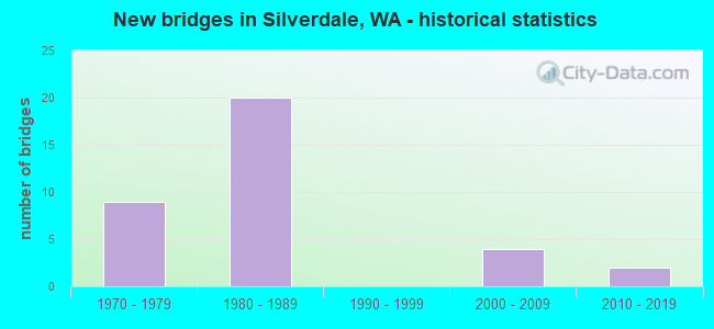
- New bridges - historical statistics
- 91970-1979
- 201980-1989
- 42000-2009
- 22010-2019
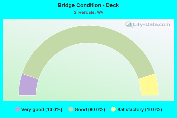
- Bridge Condition - Deck
- 10.0%Very good
- 80.0%Good
- 10.0%Satisfactory

- Bridge Condition - Superstructure
- 15.0%Very good
- 70.0%Good
- 5.0%Satisfactory
- 10.0%Fair
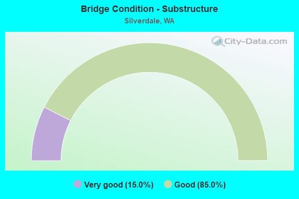
- Bridge Condition - Substructure
- 15.0%Very good
- 85.0%Good
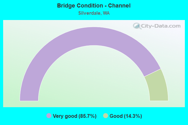
- Bridge Condition - Channel
- 85.7%Very good
- 14.3%Good
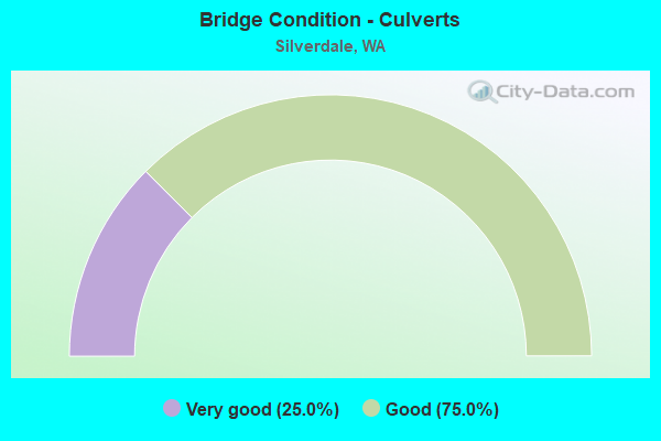
- Bridge Condition - Culverts
- 25.0%Very good
- 75.0%Good
Find on map >> Show street view
Structure Number: 9124A, Location: 9.9 N JCT SR 304 (Lat: 47.653733, Lng: -122.705892), Route carried "on" structure: State highway 3, Year Built: 1972, Status: Open, Structure Length: 4.45m (14.60ft), Average Daily Traffic: 26,694 (year 2019), Truck Traffic: 7%, Average Future Daily Traffic: 35,449 (year 2039), Design Load: HS 20+Mod, Features Intersected: ANDERSON HILL RD
Minimum Vertical Clearance: 30+ m (98+ ft), Kilometerpoint: 71.938, Lanes on structure: 2, Lanes under structure: 3, Base Highway Network: Yes, Owner: State Highway Agency, Approaching Roadway Width: 12.2m (40.0ft), Material/Design: Prestressed concrete continuous, Design/Construction: Stringer/Multi-beam, Number Of Spans In Main Unit: 3, Length of Maximum Span: 18.9m (62.0ft), Curb or Sidewalk Widths: Left: 0.2m (0.7ft), Right: 0.2m (0.7ft), Curb-To-Curb Width: 11.6m (38.1ft), Out-to-Out Width: 12.3m (40.4ft)
Condition: Deck: Satisfactory, Superstructure: Fair, Substructure: Good, Operating Rating: 61.7 metric tons, Method Used To Determine Operating Rating: Load Factor (LF), Inventory Rating: 36.3 metric tons, Method Used To Determine Inventory Rating: Load Factor (LF), Structural Evaluation: Somewhat better than minimum adequacy, Deck Geometry: Equal to present minimum criteria, Underclear: Somewhat better than minimum adequacy, Approach Roadway Alignment: Equal to present desirable criteria, Length Of Structure Improvement: 4.45m (14.60ft), Designated Inspection Frequency: Every 24 months, Inspection Date: Febuary 2020, Bridge Improvement Cost: $1,226,000, Roadway Improvement Cost: $245,000, Total Project Cost: $2,453,000 ( Estimate for 2014), Deck Structure Type: Concrete Cast-file-Place, Wearing Surface/Protective System: Wearing Surface: Monolithic Concrete
Find on map >> Show street view
Structure Number: 9269B, Location: 8.7 N JCT SR 304 (Lat: 47.636722, Lng: -122.707194), Route carried "on" structure: State highway 3, Year Built: 1972, Status: Open, Structure Length: 7.07m (23.20ft), Average Daily Traffic: 23,974 (year 2019), Truck Traffic: 7%, Average Future Daily Traffic: 31,837 (year 2039), Design Load: HS 20+Mod, Features Intersected: NEWBERRY HILL RD
Minimum Vertical Clearance: 30+ m (98+ ft), Kilometerpoint: 69.990, Lanes on structure: 2, Lanes under structure: 3, Base Highway Network: Yes, Owner: State Highway Agency, Approaching Roadway Width: 11.6m (38.1ft), Skew: 3 degrees, Material/Design: Prestressed concrete continuous, Design/Construction: Stringer/Multi-beam, Number Of Spans In Main Unit: 3, Length of Maximum Span: 30.2m (99.1ft), Curb or Sidewalk Widths: Left: 0.2m (0.7ft), Right: 0.2m (0.7ft), Curb-To-Curb Width: 11.6m (38.1ft), Out-to-Out Width: 12.6m (41.3ft)
Condition: Deck: Good, Superstructure: Good, Substructure: Good, Operating Rating: 59.9 metric tons, Method Used To Determine Operating Rating: Load Factor (LF), Inventory Rating: 35.4 metric tons, Method Used To Determine Inventory Rating: Load Factor (LF), Structural Evaluation: Better than present minimum criteria, Deck Geometry: Equal to present minimum criteria, Underclear: Better than present minimum criteria, Approach Roadway Alignment: Equal to present desirable criteria, Length Of Structure Improvement: 7.07m (23.20ft), Designated Inspection Frequency: Every 48 months, Inspection Date: March 2020, Bridge Improvement Cost: $1,856,000, Roadway Improvement Cost: $371,000, Total Project Cost: $3,712,000 ( Estimate for 2014), Deck Structure Type: Concrete Cast-file-Place, Wearing Surface/Protective System: Wearing Surface: Monolithic Concrete
Find on map >> Show street view
Structure Number: 9269C, Location: 8.7 N JCT SR 304 (Lat: 47.636700, Lng: -122.707669), Route carried "on" structure: State highway 3, Year Built: 1972, Status: Open, Structure Length: 7.35m (24.11ft), Average Daily Traffic: 23,974 (year 2019), Truck Traffic: 7%, Average Future Daily Traffic: 31,837 (year 2039), Design Load: HS 20+Mod, Features Intersected: NEWBERRY HILL RD
Minimum Vertical Clearance: 30+ m (98+ ft), Kilometerpoint: 69.974, Lanes on structure: 2, Lanes under structure: 3, Base Highway Network: Yes, Owner: State Highway Agency, Approaching Roadway Width: 11.6m (38.1ft), Skew: 3 degrees, Material/Design: Prestressed concrete continuous, Design/Construction: Stringer/Multi-beam, Number Of Spans In Main Unit: 3, Length of Maximum Span: 30.2m (99.1ft), Curb or Sidewalk Widths: Left: 0.2m (0.7ft), Right: 0.2m (0.7ft), Curb-To-Curb Width: 11.6m (38.1ft), Out-to-Out Width: 12.6m (41.3ft)
Condition: Deck: Good, Superstructure: Good, Substructure: Good, Operating Rating: 59.0 metric tons, Method Used To Determine Operating Rating: Load Factor (LF), Inventory Rating: 34.5 metric tons, Method Used To Determine Inventory Rating: Load Factor (LF), Structural Evaluation: Better than present minimum criteria, Deck Geometry: Equal to present minimum criteria, Underclear: Superior to present desirable criteria, Approach Roadway Alignment: Equal to present desirable criteria, Length Of Structure Improvement: 7.35m (24.11ft), Designated Inspection Frequency: Every 24 months, Inspection Date: Febuary 2022, Bridge Improvement Cost: $2,290,000, Roadway Improvement Cost: $458,000, Total Project Cost: $4,579,000 ( Estimate for 2022), Deck Structure Type: Concrete Cast-file-Place, Wearing Surface/Protective System: Wearing Surface: Monolithic Concrete
Find on map >> Show street view
Structure Number: 10331A, Location: JCT SR 3 (Lat: 47.661333, Lng: -122.693028), Route carried "on" structure: State highway 303, Year Built: 1977, Status: Open, Structure Length: 5.82m (19.09ft), Average Daily Traffic: 26,526 (year 2019), Truck Traffic: 3%, Average Future Daily Traffic: 35,226 (year 2039), Design Load: HS 20+Mod, Features Intersected: SR 3
Minimum Vertical Clearance: 30+ m (98+ ft), Kilometerpoint: 14.597, Lanes on structure: 4, Lanes under structure: 5, Base Highway Network: Yes, Owner: State Highway Agency, Approaching Roadway Width: 15.8m (51.8ft), Skew: 2 degrees, Material/Design: Prestressed concrete continuous, Design/Construction: Stringer/Multi-beam, Number Of Spans In Main Unit: 2, Length of Maximum Span: 29.0m (95.1ft), Curb or Sidewalk Widths: Left: 1.5m (4.9ft), Right: 1.5m (4.9ft), Curb-To-Curb Width: 15.2m (49.9ft), Out-to-Out Width: 18.9m (62.0ft)
Condition: Deck: Good, Superstructure: Good, Substructure: Good, Operating Rating: 46.3 metric tons, Method Used To Determine Operating Rating: Load Factor (LF), Inventory Rating: 28.1 metric tons, Method Used To Determine Inventory Rating: Load Factor (LF), Structural Evaluation: Better than present minimum criteria, Deck Geometry: High priority of replacement, Underclear: High priority of corrective action, Approach Roadway Alignment: Equal to present desirable criteria, Length Of Structure Improvement: 5.82m (19.09ft), Designated Inspection Frequency: Every 24 months, Inspection Date: July 2021, Bridge Improvement Cost: $2,063,000, Roadway Improvement Cost: $413,000, Total Project Cost: $4,126,000 ( Estimate for 2014), Deck Structure Type: Concrete Cast-file-Place, Wearing Surface/Protective System: Wearing Surface: Bituminous
Find on map >> Show street view
Structure Number: 10729A, Location: 9.9 N JCT SR 304 (Lat: 47.653739, Lng: -122.705469), Route carried "on" structure: State highway 3, Year Built: 1978, Status: Open, Structure Length: 4.45m (14.60ft), Average Daily Traffic: 26,694 (year 2019), Truck Traffic: 7%, Average Future Daily Traffic: 35,449 (year 2039), Design Load: HS 20+Mod, Features Intersected: ANDERSON HILL RD
Minimum Vertical Clearance: 30+ m (98+ ft), Kilometerpoint: 71.938, Lanes on structure: 2, Lanes under structure: 2, Base Highway Network: Yes, Owner: State Highway Agency, Approaching Roadway Width: 12.2m (40.0ft), Material/Design: Prestressed concrete continuous, Design/Construction: Stringer/Multi-beam, Number Of Spans In Main Unit: 3, Length of Maximum Span: 18.9m (62.0ft), Curb-To-Curb Width: 11.6m (38.1ft), Out-to-Out Width: 12.5m (41.0ft)
Condition: Deck: Satisfactory, Superstructure: Good, Substructure: Good, Operating Rating: 61.7 metric tons, Method Used To Determine Operating Rating: Load Factor (LF), Inventory Rating: 36.3 metric tons, Method Used To Determine Inventory Rating: Load Factor (LF), Structural Evaluation: Better than present minimum criteria, Deck Geometry: Equal to present minimum criteria, Underclear: Equal to present minimum criteria, Approach Roadway Alignment: Equal to present desirable criteria, Length Of Structure Improvement: 4.45m (14.60ft), Designated Inspection Frequency: Every 24 months, Inspection Date: Febuary 2020, Bridge Improvement Cost: $1,226,000, Roadway Improvement Cost: $245,000, Total Project Cost: $2,453,000 ( Estimate for 2014), Deck Structure Type: Concrete Cast-file-Place, Wearing Surface/Protective System: Wearing Surface: Monolithic Concrete
Find on map >> Show street view
Structure Number: 11375A, Location: 2.1 N JCT SR 303 (Lat: 47.693850, Lng: -122.687511), Route carried "on" structure: County highway , Year Built: 1980, Status: Open, Structure Length: 7.68m (25.20ft), Average Daily Traffic: 320 (year 2002), Truck Traffic: 1%, Average Future Daily Traffic: 447 (year 2038), Design Load: HS 20+Mod, Features Intersected: SR 3, Facility Carried by Structure: MOUNTAIN VIEW RD
Minimum Vertical Clearance: 30+ m (98+ ft), Kilometerpoint: 1.899, Lanes on structure: 2, Lanes under structure: 6, Owner: State Highway Agency, Approaching Roadway Width: 8.5m (27.9ft), Material/Design: Prestressed concrete continuous, Design/Construction: Stringer/Multi-beam, Number Of Spans In Main Unit: 2, Length of Maximum Span: 42.1m (138.1ft), Curb-To-Curb Width: 10.4m (34.1ft), Out-to-Out Width: 11.3m (37.1ft)
Condition: Deck: Good, Superstructure: Satisfactory, Substructure: Good, Operating Rating: 22.0 metric tons, Method Used To Determine Operating Rating: Load and Resistance Factor Rating (LRFR) rating reported by rating factor(RF) method using HL-93 loadings, Inventory Rating: 16.8 metric tons, Method Used To Determine Inventory Rating: Load and Resistance Factor Rating (LRFR) rating reported by rating factor(RF) method using HL-93 loadings, Structural Evaluation: Somewhat better than minimum adequacy, Deck Geometry: Better than present minimum criteria, Underclear: Somewhat better than minimum adequacy, Approach Roadway Alignment: Equal to present desirable criteria, Length Of Structure Improvement: 7.68m (25.20ft), Designated Inspection Frequency: Every 24 months, Inspection Date: Febuary 2020, Bridge Improvement Cost: $1,512,000, Roadway Improvement Cost: $302,000, Total Project Cost: $3,024,000 ( Estimate for 2014), Deck Structure Type: Concrete Cast-file-Place, Wearing Surface/Protective System: Wearing Surface: Bituminous, Membrane: Preformed Fabric
Find on map >> Show street view
Structure Number: 11375B, Location: 2.6 N JCT SR 303 (Lat: 47.700981, Lng: -122.684683), Route carried "on" structure: State highway 3, Year Built: 1981, Status: Open, Structure Length: 4.33m (14.21ft), Average Daily Traffic: 20,221 (year 2019), Truck Traffic: 7%, Average Future Daily Traffic: 26,853 (year 2039), Design Load: HS 20+Mod, Features Intersected: SR 308 (LUOTO RD)
Minimum Vertical Clearance: 30+ m (98+ ft), Kilometerpoint: 78.021, Lanes on structure: 2, Lanes under structure: 4, Base Highway Network: Yes, Owner: State Highway Agency, Approaching Roadway Width: 11.6m (38.1ft), Skew: 1 degrees, Material/Design: Prestressed concrete, Design/Construction: Stringer/Multi-beam, Number Of Spans In Main Unit: 1, Length of Maximum Span: 43.3m (142.1ft), Curb-To-Curb Width: 11.6m (38.1ft), Out-to-Out Width: 12.5m (41.0ft)
Condition: Deck: Good, Superstructure: Good, Substructure: Good, Operating Rating: 66.2 metric tons, Method Used To Determine Operating Rating: Load Factor (LF), Inventory Rating: 39.0 metric tons, Method Used To Determine Inventory Rating: Load Factor (LF), Structural Evaluation: Better than present minimum criteria, Deck Geometry: Equal to present minimum criteria, Underclear: Somewhat better than minimum adequacy, Approach Roadway Alignment: Equal to present desirable criteria, Length Of Structure Improvement: 4.33m (14.21ft), Designated Inspection Frequency: Every 24 months, Inspection Date: Febuary 2020, Bridge Improvement Cost: $1,136,000, Roadway Improvement Cost: $227,000, Total Project Cost: $2,272,000 ( Estimate for 2014), Deck Structure Type: Concrete Cast-file-Place, Wearing Surface/Protective System: Wearing Surface: Bituminous, Membrane: Preformed Fabric
Find on map >> Show street view
Structure Number: 11375C, Location: 2.6 N JCT SR 303 (Lat: 47.701061, Lng: -122.684964), Route carried "on" structure: State highway 3, Year Built: 1981, Status: Open, Structure Length: 4.18m (13.71ft), Average Daily Traffic: 20,221 (year 2019), Truck Traffic: 7%, Average Future Daily Traffic: 26,853 (year 2039), Design Load: HS 20+Mod, Features Intersected: SR 308 (LUOTO RD)
Minimum Vertical Clearance: 30+ m (98+ ft), Kilometerpoint: 78.021, Lanes on structure: 2, Lanes under structure: 4, Base Highway Network: Yes, Owner: State Highway Agency, Approaching Roadway Width: 12.2m (40.0ft), Skew: 1 degrees, Material/Design: Prestressed concrete, Design/Construction: Stringer/Multi-beam, Number Of Spans In Main Unit: 1, Length of Maximum Span: 41.8m (137.1ft), Curb-To-Curb Width: 11.6m (38.1ft), Out-to-Out Width: 12.5m (41.0ft)
Condition: Deck: Good, Superstructure: Good, Substructure: Good, Operating Rating: 66.2 metric tons, Method Used To Determine Operating Rating: Load Factor (LF), Inventory Rating: 39.0 metric tons, Method Used To Determine Inventory Rating: Load Factor (LF), Structural Evaluation: Better than present minimum criteria, Deck Geometry: Equal to present minimum criteria, Underclear: Somewhat better than minimum adequacy, Approach Roadway Alignment: Equal to present desirable criteria, Length Of Structure Improvement: 4.18m (13.71ft), Designated Inspection Frequency: Every 24 months, Inspection Date: Febuary 2020, Bridge Improvement Cost: $1,151,000, Roadway Improvement Cost: $230,000, Total Project Cost: $2,302,000 ( Estimate for 2014), Deck Structure Type: Concrete Cast-file-Place, Wearing Surface/Protective System: Wearing Surface: Bituminous, Membrane: Preformed Fabric
Find on map >> Show street view
Structure Number: 11375D, Location: 2.6 N JCT SR 303 (Lat: 47.700558, Lng: -122.684408), Route carried "on" structure: Ramp State highway 3, Year Built: 1981, Status: Open, Structure Length: 18.65m (61.19ft), Average Daily Traffic: 3,955 (year 2019), Truck Traffic: 9%, Average Future Daily Traffic: 5,252 (year 2039), Design Load: HS 20+Mod, Features Intersected: SR 3, Facility Carried by Structure: N-W RAMP TO LUOTO
Minimum Vertical Clearance: 30+ m (98+ ft), Kilometerpoint: 0.370, Lanes on structure: 2, Lanes under structure: 9, Owner: State Highway Agency, Approaching Roadway Width: 11.6m (38.1ft), Material/Design: Concrete continuous, Design/Construction: Box Beam or Girders - Multiple, Number Of Spans In Main Unit: 6, Length of Maximum Span: 39.9m (130.9ft), Curb-To-Curb Width: 11.6m (38.1ft), Out-to-Out Width: 12.5m (41.0ft)
Condition: Deck: Good, Superstructure: Good, Substructure: Good, Operating Rating: 36.9 metric tons, Method Used To Determine Operating Rating: Load and Resistance Factor Rating (LRFR) rating reported by rating factor(RF) method using HL-93 loadings, Inventory Rating: 28.5 metric tons, Method Used To Determine Inventory Rating: Load and Resistance Factor Rating (LRFR) rating reported by rating factor(RF) method using HL-93 loadings, Structural Evaluation: Better than present minimum criteria, Deck Geometry: Superior to present desirable criteria, Underclear: Meets minimum limits, Approach Roadway Alignment: Equal to present desirable criteria, Length Of Structure Improvement: 18.65m (61.19ft), Designated Inspection Frequency: Every 24 months, Inspection Date: Febuary 2020, Bridge Improvement Cost: $4,896,000, Roadway Improvement Cost: $979,000, Total Project Cost: $9,792,000 ( Estimate for 2014), Deck Structure Type: Concrete Cast-file-Place, Wearing Surface/Protective System: Wearing Surface: Bituminous, Membrane: Preformed Fabric
Find on map >> Show street view
Structure Number: 11591A, Location: 1.0 N JCT SR 303 (Lat: 47.678556, Lng: -122.691528), Route carried "on" structure: County highway , Year Built: 1979, Status: Open, Structure Length: 7.35m (24.11ft), Average Daily Traffic: 5,355 (year 2012), Truck Traffic: 1%, Average Future Daily Traffic: 8,439 (year 2036), Design Load: HS 20+Mod, Features Intersected: SR 3, Facility Carried by Structure: TRIGGER AVE
Minimum Vertical Clearance: 30+ m (98+ ft), Kilometerpoint: 0.080, Lanes on structure: 2, Lanes under structure: 6, Owner: State Highway Agency, Approaching Roadway Width: 12.2m (40.0ft), Material/Design: Prestressed concrete continuous, Design/Construction: Stringer/Multi-beam, Number Of Spans In Main Unit: 2, Length of Maximum Span: 38.4m (126.0ft), Curb-To-Curb Width: 12.2m (40.0ft), Out-to-Out Width: 13.1m (43.0ft)
Condition: Deck: Good, Superstructure: Good, Substructure: Good, Operating Rating: 52.6 metric tons, Method Used To Determine Operating Rating: Load Factor (LF), Inventory Rating: 30.8 metric tons, Method Used To Determine Inventory Rating: Load Factor (LF), Structural Evaluation: Better than present minimum criteria, Deck Geometry: Somewhat better than minimum adequacy, Underclear: Somewhat better than minimum adequacy, Approach Roadway Alignment: Equal to present desirable criteria, Length Of Structure Improvement: 7.35m (24.11ft), Designated Inspection Frequency: Every 24 months, Inspection Date: March 2020, Bridge Improvement Cost: $2,024,000, Roadway Improvement Cost: $405,000, Total Project Cost: $4,049,000 ( Estimate for 2014), Deck Structure Type: Concrete Cast-file-Place, Wearing Surface/Protective System: Wearing Surface: Bituminous, Membrane: Preformed Fabric
Find on map >> Show street view
Structure Number: 11864A, Location: JCT SR 3 (Lat: 47.664694, Lng: -122.687639), Route carried "on" structure: State highway 303, Year Built: 1981, Year Reconstructed: 2007, Status: Open, Structure Length: 7.38m (24.21ft), Average Daily Traffic: 36,265 (year 2019), Truck Traffic: 3%, Average Future Daily Traffic: 48,159 (year 2039), Design Load: HS 20+Mod, Features Intersected: SR 3
Minimum Vertical Clearance: 30+ m (98+ ft), Kilometerpoint: 13.985, Lanes on structure: 6, Lanes under structure: 4, Base Highway Network: Yes, Owner: State Highway Agency, Approaching Roadway Width: 19.5m (64.0ft), Skew: 2 degrees, Material/Design: Prestressed concrete continuous, Design/Construction: Stringer/Multi-beam, Number Of Spans In Main Unit: 2, Length of Maximum Span: 41.8m (137.1ft), Curb-To-Curb Width: 28.2m (92.5ft), Out-to-Out Width: 29.1m (95.5ft)
Condition: Deck: Good, Superstructure: Good, Substructure: Good, Operating Rating: 58.0 metric tons, Method Used To Determine Operating Rating: Load Factor (LF), Inventory Rating: 34.5 metric tons, Method Used To Determine Inventory Rating: Load Factor (LF), Structural Evaluation: Better than present minimum criteria, Deck Geometry: Equal to present minimum criteria, Underclear: High priority of corrective action, Approach Roadway Alignment: Equal to present desirable criteria, Length Of Structure Improvement: 7.38m (24.21ft), Designated Inspection Frequency: Every 24 months, Inspection Date: August 2021, Bridge Improvement Cost: $3,194,000, Roadway Improvement Cost: $639,000, Total Project Cost: $6,389,000 ( Estimate for 2014), Deck Structure Type: Concrete Cast-file-Place, Wearing Surface/Protective System: Wearing Surface: Monolithic Concrete, Deck Protection: Epoxy Coated Reinforcing
Find on map >> Show street view
Structure Number: 11864B, Location: 0.3 W SR 3 (Lat: 47.700903, Lng: -122.692139), Route carried "on" structure: County highway , Year Built: 1981, Status: Open, Structure Length: 6.19m (20.31ft), Average Daily Traffic: 3,389 (year 2002), Truck Traffic: 10%, Average Future Daily Traffic: 6,154 (year 2036), Design Load: HS 20+Mod, Features Intersected: SR 3 ACCESS - LUOTO ROAD, Facility Carried by Structure: CLEAR CREEK RD NW
Minimum Vertical Clearance: 30+ m (98+ ft), Kilometerpoint: 4.216, Lanes on structure: 2, Lanes under structure: 6, Owner: State Highway Agency, Approaching Roadway Width: 10.4m (34.1ft), Material/Design: Prestressed concrete, Design/Construction: Stringer/Multi-beam, Number Of Spans In Main Unit: 1, Number Of Approach Spans: 2, Length of Maximum Span: 42.7m (140.1ft), Curb-To-Curb Width: 10.4m (34.1ft), Out-to-Out Width: 11.3m (37.1ft)
Condition: Deck: Good, Superstructure: Good, Substructure: Good, Operating Rating: 62.6 metric tons, Method Used To Determine Operating Rating: Load Factor (LF), Inventory Rating: 37.2 metric tons, Method Used To Determine Inventory Rating: Load Factor (LF), Structural Evaluation: Better than present minimum criteria, Deck Geometry: Somewhat better than minimum adequacy, Underclear: Meets minimum limits, Approach Roadway Alignment: Equal to present desirable criteria, Length Of Structure Improvement: 6.19m (20.31ft), Designated Inspection Frequency: Every 24 months, Inspection Date: April 2021, Bridge Improvement Cost: $1,462,000, Roadway Improvement Cost: $292,000, Total Project Cost: $2,923,000 ( Estimate for 2014), Deck Structure Type: Concrete Cast-file-Place, Wearing Surface/Protective System: Wearing Surface: Monolithic Concrete, Deck Protection: Epoxy Coated Reinforcing
Find on map >> Show street view
Structure Number: 81758, Location: 6.6 N JCT SR 304 (Lat: 47.650131, Lng: -122.650350), Route carried "on" structure: County highway , Year Built: 1982, Status: Open, Structure Length: 6.34m (20.80ft), Average Daily Traffic: 9,751 (year 2019), Truck Traffic: 3%, Average Future Daily Traffic: 12,949 (year 2039), Design Load: HS 20, Features Intersected: SR 303, Facility Carried by Structure: CENTRAL VALLEY RD.
Minimum Vertical Clearance: 30+ m (98+ ft), Kilometerpoint: 0.129, Lanes on structure: 2, Lanes under structure: 6, Owner: State Highway Agency, Approaching Roadway Width: 15.5m (50.9ft), Material/Design: Prestressed concrete continuous, Design/Construction: Stringer/Multi-beam, Number Of Spans In Main Unit: 2, Length of Maximum Span: 32.3m (106.0ft), Curb-To-Curb Width: 17.7m (58.1ft), Out-to-Out Width: 18.6m (61.0ft)
Condition: Deck: Good, Superstructure: Fair, Substructure: Good, Operating Rating: 83.4 metric tons, Method Used To Determine Operating Rating: Load Factor (LF), Inventory Rating: 49.9 metric tons, Method Used To Determine Inventory Rating: Load Factor (LF), Structural Evaluation: Somewhat better than minimum adequacy, Deck Geometry: Superior to present desirable criteria, Underclear: High priority of corrective action, Approach Roadway Alignment: Equal to present desirable criteria, Length Of Structure Improvement: 6.34m (20.80ft), Designated Inspection Frequency: Every 24 months, Inspection Date: Febuary 2022, Bridge Improvement Cost: $2,618,000, Roadway Improvement Cost: $524,000, Total Project Cost: $5,236,000 ( Estimate for 2022), Deck Structure Type: Concrete Cast-file-Place, Wearing Surface/Protective System: Wearing Surface: Monolithic Concrete, Deck Protection: Epoxy Coated Reinforcing
Find on map >> Show street view
Structure Number: 81878, Location: 7.7 N JCT SR 304 (Lat: 47.656211, Lng: -122.670811), Route carried "on" structure: State highway 303, Year Built: 1982, Status: Open, Structure Length: 3.63m (11.91ft), Average Daily Traffic: 14,829 (year 2019), Truck Traffic: 3%, Average Future Daily Traffic: 19,692 (year 2039), Design Load: HS 20, Features Intersected: RIDGETOP BLVD NW
Minimum Vertical Clearance: 30+ m (98+ ft), Kilometerpoint: 12.328, Lanes on structure: 3, Lanes under structure: 3, Base Highway Network: Yes, Owner: State Highway Agency, Approaching Roadway Width: 14.6m (47.9ft), Material/Design: Prestressed concrete, Design/Construction: Stringer/Multi-beam, Number Of Spans In Main Unit: 1, Length of Maximum Span: 35.1m (115.2ft), Curb-To-Curb Width: 14.6m (47.9ft), Out-to-Out Width: 15.5m (50.9ft)
Condition: Deck: Good, Superstructure: Good, Substructure: Good, Operating Rating: 89.8 metric tons, Method Used To Determine Operating Rating: Load Factor (LF), Inventory Rating: 60.8 metric tons, Method Used To Determine Inventory Rating: Load Factor (LF), Structural Evaluation: Better than present minimum criteria, Deck Geometry: Meets minimum limits, Underclear: Meets minimum limits, Approach Roadway Alignment: Equal to present desirable criteria, Length Of Structure Improvement: 3.63m (11.91ft), Designated Inspection Frequency: Every 24 months, Inspection Date: Febuary 2022, Bridge Improvement Cost: $1,413,000, Roadway Improvement Cost: $283,000, Total Project Cost: $2,826,000 ( Estimate for 2022), Deck Structure Type: Concrete Cast-file-Place, Wearing Surface/Protective System: Wearing Surface: Monolithic Concrete, Deck Protection: Epoxy Coated Reinforcing
Find on map >> Show street view
Structure Number: 81879, Location: 7.7 N JCT SR 304 (Lat: 47.656378, Lng: -122.670614), Route carried "on" structure: State highway 303, Year Built: 1982, Status: Open, Structure Length: 3.63m (11.91ft), Average Daily Traffic: 14,829 (year 2019), Truck Traffic: 3%, Average Future Daily Traffic: 19,692 (year 2039), Design Load: HS 20, Features Intersected: RIDGETOP BLVD NW
Minimum Vertical Clearance: 30+ m (98+ ft), Kilometerpoint: 12.328, Lanes on structure: 3, Lanes under structure: 3, Base Highway Network: Yes, Owner: State Highway Agency, Approaching Roadway Width: 14.6m (47.9ft), Material/Design: Prestressed concrete, Design/Construction: Stringer/Multi-beam, Number Of Spans In Main Unit: 1, Length of Maximum Span: 35.1m (115.2ft), Curb-To-Curb Width: 14.6m (47.9ft), Out-to-Out Width: 15.5m (50.9ft)
Condition: Deck: Good, Superstructure: Good, Substructure: Good, Operating Rating: 89.8 metric tons, Method Used To Determine Operating Rating: Load Factor (LF), Inventory Rating: 60.8 metric tons, Method Used To Determine Inventory Rating: Load Factor (LF), Structural Evaluation: Better than present minimum criteria, Deck Geometry: Meets minimum limits, Underclear: Meets minimum limits, Approach Roadway Alignment: Equal to present desirable criteria, Length Of Structure Improvement: 3.63m (11.91ft), Designated Inspection Frequency: Every 24 months, Inspection Date: Febuary 2022, Bridge Improvement Cost: $1,413,000, Roadway Improvement Cost: $283,000, Total Project Cost: $2,826,000 ( Estimate for 2022), Deck Structure Type: Concrete Cast-file-Place, Wearing Surface/Protective System: Wearing Surface: Monolithic Concrete, Deck Protection: Epoxy Coated Reinforcing
Find on map >> Show street view
Structure Number: 82008, Location: 0.2 S JCT SR 3 (Lat: 47.664000, Lng: -122.683333), Route carried "on" structure: State highway 303, Year Built: 1982, Status: Open, Structure Length: 3.41m (11.19ft), Average Daily Traffic: 36,265 (year 2019), Truck Traffic: 3%, Average Future Daily Traffic: 48,159 (year 2039), Design Load: HS 20, Features Intersected: SILVERDALE WAY NW
Minimum Vertical Clearance: 30+ m (98+ ft), Kilometerpoint: 13.631, Lanes on structure: 4, Lanes under structure: 4, Base Highway Network: Yes, Owner: State Highway Agency, Approaching Roadway Width: 20.7m (67.9ft), Material/Design: Prestressed concrete, Design/Construction: Stringer/Multi-beam, Number Of Spans In Main Unit: 1, Length of Maximum Span: 32.6m (107.0ft), Curb-To-Curb Width: 19.5m (64.0ft), Out-to-Out Width: 20.4m (66.9ft)
Condition: Deck: Good, Superstructure: Good, Substructure: Good, Operating Rating: 89.8 metric tons, Method Used To Determine Operating Rating: Load Factor (LF), Inventory Rating: 60.8 metric tons, Method Used To Determine Inventory Rating: Load Factor (LF), Structural Evaluation: Better than present minimum criteria, Deck Geometry: Somewhat better than minimum adequacy, Underclear: Meets minimum limits, Approach Roadway Alignment: Equal to present desirable criteria, Length Of Structure Improvement: 3.41m (11.19ft), Designated Inspection Frequency: Every 24 months, Inspection Date: March 2020, Bridge Improvement Cost: $1,568,000, Roadway Improvement Cost: $314,000, Total Project Cost: $3,136,000 ( Estimate for 2014), Deck Structure Type: Concrete Cast-file-Place, Wearing Surface/Protective System: Wearing Surface: Monolithic Concrete, Deck Protection: Epoxy Coated Reinforcing
Find on map >> Show street view
Structure Number: 85739, Location: 0.2 E SILVERDALE WAY NW (Lat: 47.654086, Lng: -122.685375), Route carried "on" structure: County highway 56791, Year Built: 1989, Status: Open, Structure Length: 0.94m (3.08ft), Average Daily Traffic: 10,894 (year 2020), Truck Traffic: 6%, Average Future Daily Traffic: 11,983 (year 2042), Design Load: HS 20, Features Intersected: CLEAR CREEK, Facility Carried by Structure: RIDGETOP BLVD NW
Minimum Vertical Clearance: 30+ m (98+ ft), Kilometerpoint: 0.001, Lanes on structure: 3, Base Highway Network: Yes, Owner: County Highway Agency, Approaching Roadway Width: 10.4m (34.1ft), Material/Design: Steel, Design/Construction: Culvert, Number Of Spans In Main Unit: 1, Length of Maximum Span: 9.4m (30.8ft)
Condition: Channel: Good, Culverts: Good, Operating Rating: 59.0 metric tons, Method Used To Determine Operating Rating: Load Factor (LF) rating reported by rating factor (RF) method using MS18 loading, Inventory Rating: 35.3 metric tons, Method Used To Determine Inventory Rating: Load Factor (LF) rating reported by rating factor (RF) method using MS18 loading, Structural Evaluation: Better than present minimum criteria, Waterway Adequacy: Equal to present desirable criteria, Approach Roadway Alignment: Equal to present desirable criteria, Length Of Structure Improvement: 0.94m (3.08ft), Designated Inspection Frequency: Every 24 months, Inspection Date: January 2021, Bridge Improvement Cost: $223,000, Roadway Improvement Cost: $45,000, Total Project Cost: $446,000 ( Estimate for 2014)
Find on map >> Show street view
Structure Number: 86066, Location: .1 MILE WEST OF SR3 (Lat: 47.678431, Lng: -122.698883), Route carried "on" structure: County highway 57770, Year Built: 1979, Status: Open, Structure Length: 4.30m (14.11ft), Average Daily Traffic: 4,517 (year 2020), Truck Traffic: 11%, Average Future Daily Traffic: 4,969 (year 2042), Design Load: HS 20, Features Intersected: TRIGGER AVE, Facility Carried by Structure: CLEAR CREEK ROAD
Minimum Vertical Clearance: 30+ m (98+ ft), Kilometerpoint: 0.001, Lanes on structure: 2, Lanes under structure: 4, Owner: County Highway Agency, Approaching Roadway Width: 12.2m (40.0ft), Material/Design: Prestressed concrete, Design/Construction: Stringer/Multi-beam, Number Of Spans In Main Unit: 1, Length of Maximum Span: 41.5m (136.2ft), Curb-To-Curb Width: 12.2m (40.0ft), Out-to-Out Width: 12.6m (41.3ft)
Condition: Deck: Good, Superstructure: Good, Substructure: Good, Operating Rating: 47.6 metric tons, Method Used To Determine Operating Rating: Load Factor (LF) rating reported by rating factor (RF) method using MS18 loading, Inventory Rating: 28.5 metric tons, Method Used To Determine Inventory Rating: Load Factor (LF) rating reported by rating factor (RF) method using MS18 loading, Structural Evaluation: Better than present minimum criteria, Deck Geometry: Equal to present minimum criteria, Underclear: Meets minimum limits, Approach Roadway Alignment: Equal to present desirable criteria, Length Of Structure Improvement: 4.30m (14.11ft), Designated Inspection Frequency: Every 24 months, Inspection Date: Febuary 2021, Bridge Improvement Cost: $1,184,000, Roadway Improvement Cost: $237,000, Total Project Cost: $2,369,000 ( Estimate for 2014), Deck Structure Type: Concrete Cast-file-Place, Wearing Surface/Protective System: Wearing Surface: Bituminous, Membrane: Preformed Fabric
Find on map >> Show street view
Structure Number: 87536, Location: 0.15 E JCT SILVRDLE WY NW (Lat: 47.659578, Lng: -122.682644), Route carried "on" structure: County highway 57720, Year Built: 2006, Status: Open, Structure Length: 2.13m (6.99ft), Average Daily Traffic: 10,436 (year 2020), Truck Traffic: 7%, Average Future Daily Traffic: 11,480 (year 2042), Design Load: HS 20, Features Intersected: CLEAR CREEK, Facility Carried by Structure: MYHRE ROAD
Minimum Vertical Clearance: 30+ m (98+ ft), Kilometerpoint: 0.001, Lanes on structure: 2, Owner: County Highway Agency, Approaching Roadway Width: 11.3m (37.1ft), Skew: 1 degrees, Material/Design: Prestressed concrete continuous, Design/Construction: Tee Beam, Number Of Spans In Main Unit: 1, Length of Maximum Span: 18.3m (60.0ft), Curb or Sidewalk Widths: Left: 2.0m (6.6ft), Right: 2.0m (6.6ft), Curb-To-Curb Width: 17.2m (56.4ft), Out-to-Out Width: 20.1m (65.9ft)
Condition: Deck: Good, Superstructure: Very good, Substructure: Very good, Channel: Very good, Operating Rating: 59.3 metric tons, Method Used To Determine Operating Rating: Load Factor (LF) rating reported by rating factor (RF) method using MS18 loading, Inventory Rating: 35.6 metric tons, Method Used To Determine Inventory Rating: Load Factor (LF) rating reported by rating factor (RF) method using MS18 loading, Structural Evaluation: Equal to present desirable criteria, Deck Geometry: Superior to present desirable criteria, Waterway Adequacy: Equal to present desirable criteria, Approach Roadway Alignment: Equal to present desirable criteria, Length Of Structure Improvement: 2.13m (6.99ft), Designated Inspection Frequency: Every 24 months, Inspection Date: January 2021, Bridge Improvement Cost: $546,000, Roadway Improvement Cost: $109,000, Total Project Cost: $1,092,000 ( Estimate for 2014), Deck Structure Type: Other, Wearing Surface/Protective System: Wearing Surface: Bituminous, Membrane: Preformed Fabric, Deck Protection: Epoxy Coated Reinforcing
Find on map >> Show street view
Structure Number: 87537, Location: 0.1 N JCT SR 303 (Lat: 47.665114, Lng: -122.682739), Route carried "on" structure: County highway 19515, Year Built: 2006, Status: Open, Structure Length: 1.77m (5.81ft), Average Daily Traffic: 14,889 (year 2020), Truck Traffic: 7%, Average Future Daily Traffic: 16,378 (year 2042), Design Load: HS 20, Features Intersected: CLEAR CREEK, Facility Carried by Structure: SILVERDALE WAY
Minimum Vertical Clearance: 30+ m (98+ ft), Kilometerpoint: 0.001, Lanes on structure: 2, Base Highway Network: Yes, Owner: County Highway Agency, Approaching Roadway Width: 11.0m (36.1ft), Skew: 1 degrees, Material/Design: Prestressed concrete continuous, Design/Construction: Channel Beam, Number Of Spans In Main Unit: 1, Length of Maximum Span: 15.2m (49.9ft), Curb-To-Curb Width: 16.2m (53.1ft), Out-to-Out Width: 17.1m (56.1ft)
Condition: Deck: Very good, Superstructure: Very good, Substructure: Very good, Channel: Very good, Operating Rating: 38.9 metric tons, Method Used To Determine Operating Rating: Load Factor (LF) rating reported by rating factor (RF) method using MS18 loading, Inventory Rating: 23.3 metric tons, Method Used To Determine Inventory Rating: Load Factor (LF) rating reported by rating factor (RF) method using MS18 loading, Structural Evaluation: Somewhat better than minimum adequacy, Deck Geometry: Superior to present desirable criteria, Waterway Adequacy: Equal to present desirable criteria, Approach Roadway Alignment: Equal to present desirable criteria, Length Of Structure Improvement: 1.77m (5.81ft), Designated Inspection Frequency: Every 24 months, Inspection Date: January 2021, Bridge Improvement Cost: $441,000, Roadway Improvement Cost: $88,000, Total Project Cost: $882,000 ( Estimate for 2014), Deck Structure Type: Other, Wearing Surface/Protective System: Wearing Surface: Bituminous, Deck Protection: Epoxy Coated Reinforcing
Find on map >> Show street view
Structure Number: 87556, Location: 0.42 N HWY 303 (Lat: 47.650378, Lng: -122.632139), Route carried "on" structure: County highway 57290, Year Built: 2007, Status: Open, Structure Length: 0.73m (2.40ft), Average Daily Traffic: 4,305 (year 2020), Truck Traffic: 6%, Average Future Daily Traffic: 4,736 (year 2042), Design Load: HS 25 or greater, Features Intersected: STEELE CREEK, Facility Carried by Structure: BROWNSVILLE HWY
Minimum Vertical Clearance: 30+ m (98+ ft), Kilometerpoint: 0.001, Lanes on structure: 2, Owner: County Highway Agency, Approaching Roadway Width: 9.1m (29.9ft), Skew: 5 degrees, Material/Design: Concrete, Design/Construction: Culvert, Number Of Spans In Main Unit: 1, Length of Maximum Span: 7.3m (24.0ft)
Condition: Channel: Very good, Culverts: Good, Operating Rating: 54.4 metric tons, Method Used To Determine Operating Rating: Field evaluation and documented engineering judgment, Inventory Rating: 32.7 metric tons, Method Used To Determine Inventory Rating: Field evaluation and documented engineering judgment, Structural Evaluation: Better than present minimum criteria, Waterway Adequacy: Equal to present desirable criteria, Approach Roadway Alignment: Equal to present desirable criteria, Length Of Structure Improvement: 0.73m (2.40ft), Designated Inspection Frequency: Every 24 months, Inspection Date: January 2021, Bridge Improvement Cost: $154,000, Roadway Improvement Cost: $31,000, Total Project Cost: $307,000 ( Estimate for 2014)
Find on map >> Show street view
Structure Number: 87557, Location: 0.41 N HWY 303 (Lat: 47.650950, Lng: -122.632069), Route carried "on" structure: County highway 57290, Year Built: 2007, Status: Open, Structure Length: 0.73m (2.40ft), Average Daily Traffic: 4,305 (year 2020), Truck Traffic: 6%, Average Future Daily Traffic: 4,736 (year 2042), Design Load: HS 25 or greater, Features Intersected: STEELE CREEK, Facility Carried by Structure: BROWNSVILLE
Minimum Vertical Clearance: 30+ m (98+ ft), Kilometerpoint: 0.001, Lanes on structure: 2, Owner: County Highway Agency, Approaching Roadway Width: 9.1m (29.9ft), Skew: 2 degrees, Material/Design: Concrete, Design/Construction: Culvert, Number Of Spans In Main Unit: 1, Length of Maximum Span: 7.3m (24.0ft)
Condition: Channel: Very good, Culverts: Good, Operating Rating: 54.4 metric tons, Method Used To Determine Operating Rating: Field evaluation and documented engineering judgment, Inventory Rating: 32.7 metric tons, Method Used To Determine Inventory Rating: Field evaluation and documented engineering judgment, Structural Evaluation: Better than present minimum criteria, Waterway Adequacy: Equal to present desirable criteria, Approach Roadway Alignment: Equal to present desirable criteria, Length Of Structure Improvement: 0.73m (2.40ft), Designated Inspection Frequency: Every 24 months, Inspection Date: January 2021, Bridge Improvement Cost: $154,000, Roadway Improvement Cost: $31,000, Total Project Cost: $307,000 ( Estimate for 2014)
Find on map >> Show street view
Structure Number: 88911, Location: 0.3 E SILVERDALE WAY (Lat: 47.650500, Lng: -122.685858), Route carried "on" structure: County highway 57740, Year Built: 2016, Status: Open, Structure Length: 7.32m (24.02ft), Average Daily Traffic: 14,857 (year 2020), Truck Traffic: 5%, Average Future Daily Traffic: 16,343 (year 2042), Design Load: HL 93, Features Intersected: CLEAR CREEK, Facility Carried by Structure: NW BUCKLIN HILL RD
Minimum Vertical Clearance: 30+ m (98+ ft), Kilometerpoint: 0.001, Lanes on structure: 4, Owner: County Highway Agency, Approaching Roadway Width: 17.7m (58.1ft), Material/Design: Prestressed concrete continuous, Design/Construction: Tee Beam, Number Of Spans In Main Unit: 3, Length of Maximum Span: 22.9m (75.1ft), Curb or Sidewalk Widths: Left: 2.0m (6.6ft), Right: 2.0m (6.6ft), Curb-To-Curb Width: 17.1m (56.1ft), Out-to-Out Width: 21.6m (70.9ft)
Condition: Deck: Very good, Superstructure: Very good, Substructure: Very good, Channel: Very good, Operating Rating: 54.1 metric tons, Method Used To Determine Operating Rating: Load and Resistance Factor Rating (LRFR) rating reported by rating factor(RF) method using HL-93 loadings, Inventory Rating: 41.8 metric tons, Method Used To Determine Inventory Rating: Load and Resistance Factor Rating (LRFR) rating reported by rating factor(RF) method using HL-93 loadings, Structural Evaluation: Equal to present desirable criteria, Deck Geometry: Somewhat better than minimum adequacy, Waterway Adequacy: Equal to present desirable criteria, Approach Roadway Alignment: Equal to present desirable criteria, Length Of Structure Improvement: 7.32m (24.02ft), Designated Inspection Frequency: Every 24 months, Inspection Date: March 2021, Bridge Improvement Cost: $2,880,000, Roadway Improvement Cost: $576,000, Total Project Cost: $5,760,000 ( Estimate for 2014), Deck Structure Type: Concrete Cast-file-Place, Wearing Surface/Protective System: Wearing Surface: Monolithic Concrete, Deck Protection: Epoxy Coated Reinforcing
Find on map >> Show street view
Structure Number: 88987, Location: 0.17 SE SILVERDALE WAY NW (Lat: 47.666503, Lng: -122.677919), Route carried "on" structure: County highway 3340, Year Built: 2017, Status: Open, Structure Length: 0.61m (2.00ft), Average Daily Traffic: 370 (year 2019), Truck Traffic: 29%, Average Future Daily Traffic: 407 (year 2039), Design Load: HL 93, Features Intersected: WETLANDS, Facility Carried by Structure: WOODBRIDGE ST NW
Minimum Vertical Clearance: 30+ m (98+ ft), Kilometerpoint: 0.001, Lanes on structure: 2, Owner: County Highway Agency, Approaching Roadway Width: 9.8m (32.2ft), Material/Design: Steel, Design/Construction: Culvert, Number Of Spans In Main Unit: 1, Length of Maximum Span: 6.1m (20.0ft), Curb or Sidewalk Widths: Left: 2.1m (6.9ft), Right: 0.0m
Condition: Channel: Very good, Culverts: Very good, Operating Rating: 52.8 metric tons, Method Used To Determine Operating Rating: Load and Resistance Factor Rating (LRFR) rating reported by rating factor(RF) method using HL-93 loadings, Inventory Rating: 46.7 metric tons, Method Used To Determine Inventory Rating: Load and Resistance Factor Rating (LRFR) rating reported by rating factor(RF) method using HL-93 loadings, Structural Evaluation: Equal to present desirable criteria, Waterway Adequacy: Equal to present desirable criteria, Approach Roadway Alignment: Equal to present desirable criteria, Length Of Structure Improvement: 0.61m (2.00ft), Designated Inspection Frequency: Every 24 months, Inspection Date: May 2020, Bridge Improvement Cost: $136,000, Roadway Improvement Cost: $27,000, Total Project Cost: $272,000 ( Estimate for 2014)
Find on map >> Show street view
Structure Number: 10331A, Location: 10.8 N JCT SR 304 (Lat: 47.661333, Lng: -122.693028), Route carried "under" structure: State highway 3, Year Built: 1977, Structure Length: 0. m, Average Daily Traffic: 53,388 (year 2019), Truck Traffic: 7%, Features Intersected: SR 3
Minimum Vertical Clearance: 5.44m (17.85ft), Kilometerpoint: 73.354, Lanes on structure: 4, Lanes under structure: 5, Material/Design: Prestressed concrete continuous, Design/Construction: Stringer/Multi-beam, Length of Maximum Span: 29.0m (95.1ft)
Find on map >> Show street view
Structure Number: 11375A, Location: 2.1 N JCT SR 303 (Lat: 47.693850, Lng: -122.687511), Route carried "under" structure: State highway 3, Year Built: 1980, Structure Length: 0. m, Average Daily Traffic: 40,441 (year 2019), Truck Traffic: 7%, Features Intersected: SR 3, Facility Carried by Structure: MOUNTAIN VIEW RD
Minimum Vertical Clearance: 5.36m (17.59ft), Kilometerpoint: 77.200, Lanes on structure: 2, Lanes under structure: 6, Material/Design: Prestressed concrete continuous, Design/Construction: Stringer/Multi-beam, Length of Maximum Span: 42.1m (138.1ft)
Find on map >> Show street view
Structure Number: 11375B, Location: JCT SR 3 (Lat: 47.700981, Lng: -122.684683), Route carried "under" structure: State highway 308, Year Built: 1981, Structure Length: 0. m, Average Daily Traffic: 7,619 (year 2019), Truck Traffic: 4%, Features Intersected: SR 308 (LUOTO RD), Facility Carried by Structure: SR 3
Minimum Vertical Clearance: 5.36m (17.59ft), Kilometerpoint: 0.032, Lanes on structure: 2, Lanes under structure: 5, Material/Design: Prestressed concrete, Design/Construction: Stringer/Multi-beam, Length of Maximum Span: 43.3m (142.1ft)
Find on map >> Show street view
Structure Number: 11375C, Location: JCT SR 3 (Lat: 47.701061, Lng: -122.684964), Route carried "under" structure: State highway 308, Year Built: 1981, Structure Length: 0. m, Average Daily Traffic: 7,619 (year 2019), Truck Traffic: 4%, Features Intersected: SR 308 (LUOTO RD), Facility Carried by Structure: SR 3
Minimum Vertical Clearance: 5.16m (16.93ft), Kilometerpoint: 0.001, Lanes on structure: 2, Lanes under structure: 4, Material/Design: Prestressed concrete, Design/Construction: Stringer/Multi-beam, Length of Maximum Span: 41.8m (137.1ft)
Find on map >> Show street view
Structure Number: 11375D, Location: 2.6 N JCT SR 303 (Lat: 47.700558, Lng: -122.684408), Route carried "under" structure: State highway 3, Year Built: 1981, Structure Length: 0. m, Average Daily Traffic: 40,441 (year 2019), Truck Traffic: 7%, Features Intersected: SR 3, Facility Carried by Structure: N-W RAMP TO LUOTO
Minimum Vertical Clearance: 5.13m (16.83ft), Kilometerpoint: 78.021, Lanes on structure: 2, Lanes under structure: 4, Material/Design: Concrete continuous, Design/Construction: Box Beam or Girders - Multiple, Length of Maximum Span: 39.9m (130.9ft)
Find on map >> Show street view
Structure Number: 11591A, Location: 1.0 N JCT SR 303 (Lat: 47.678556, Lng: -122.691528), Route carried "under" structure: State highway 3, Year Built: 1979, Structure Length: 0. m, Average Daily Traffic: 50,088 (year 2019), Truck Traffic: 7%, Features Intersected: SR 3, Facility Carried by Structure: TRIGGER AVE
Minimum Vertical Clearance: 5.13m (16.83ft), Kilometerpoint: 75.462, Lanes on structure: 2, Lanes under structure: 6, Material/Design: Prestressed concrete continuous, Design/Construction: Stringer/Multi-beam, Length of Maximum Span: 38.4m (126.0ft)
Find on map >> Show street view
Structure Number: 11864A, Location: 11.1 N JCT SR 304 (Lat: 47.664694, Lng: -122.687639), Route carried "under" structure: State highway 3, Year Built: 1981, Structure Length: 0. m, Average Daily Traffic: 29,906 (year 2019), Truck Traffic: 7%, Features Intersected: SR 3
Minimum Vertical Clearance: 6.73m (22.08ft), Kilometerpoint: 73.885, Lanes on structure: 6, Lanes under structure: 4, Material/Design: Prestressed concrete continuous, Design/Construction: Stringer/Multi-beam, Length of Maximum Span: 41.8m (137.1ft)
Find on map >> Show street view
Structure Number: 11864B, Location: 0.3 W SR 3 (Lat: 47.700903, Lng: -122.692139), Route carried "under" structure: County highway 3, Year Built: 1981, Structure Length: 0. m, Average Daily Traffic: 7,619 (year 2019), Truck Traffic: 4%, Features Intersected: SR 3 ACCESS - LUOTO ROAD, Facility Carried by Structure: CLEAR CREEK RD NW
Minimum Vertical Clearance: 5.46m (17.91ft), Kilometerpoint: 0.032, Lanes on structure: 2, Lanes under structure: 6, Material/Design: Prestressed concrete, Design/Construction: Stringer/Multi-beam, Length of Maximum Span: 42.7m (140.1ft)
Find on map >> Show street view
Structure Number: 81758, Location: 6.6 N JCT SR 304 (Lat: 47.650131, Lng: -122.650350), Route carried "under" structure: State highway 303, Year Built: 1982, Structure Length: 0. m, Average Daily Traffic: 36,706 (year 2019), Truck Traffic: 3%, Features Intersected: SR 303, Facility Carried by Structure: CENTRAL VALLEY RD.
Minimum Vertical Clearance: 4.78m (15.68ft), Kilometerpoint: 10.573, Lanes on structure: 2, Lanes under structure: 6, Material/Design: Prestressed concrete continuous, Design/Construction: Stringer/Multi-beam, Length of Maximum Span: 32.3m (106.0ft)
Find on map >> Show street view
Structure Number: 81878, Location: 7.7 N JCT SR 304 (Lat: 47.656211, Lng: -122.670811), Route carried "under" structure: County highway 303, Year Built: 1982, Structure Length: 0. m, Average Daily Traffic: 17,776 (year 2019), Truck Traffic: 2%, Features Intersected: RIDGETOP BLVD NW
Minimum Vertical Clearance: 5.79m (19.00ft), Kilometerpoint: 0.048, Lanes on structure: 3, Lanes under structure: 3, Material/Design: Prestressed concrete, Design/Construction: Stringer/Multi-beam, Length of Maximum Span: 35.1m (115.2ft)
Find on map >> Show street view
Structure Number: 81879, Location: 7.7 N JCT SR 304 (Lat: 47.656378, Lng: -122.670614), Route carried "under" structure: County highway 303, Year Built: 1982, Structure Length: 0. m, Average Daily Traffic: 17,776 (year 2019), Truck Traffic: 2%, Features Intersected: RIDGETOP BLVD NW
Minimum Vertical Clearance: 4.75m (15.58ft), Kilometerpoint: 0.080, Lanes on structure: 3, Lanes under structure: 3, Material/Design: Prestressed concrete, Design/Construction: Stringer/Multi-beam, Length of Maximum Span: 35.1m (115.2ft)