Bridge Statistics for Sims, North Carolina (NC)
Condition, Traffic, Stress, Structural Evaluation, Project Costs
- National Bridge Inventory (NBI) Statistics
- 10Number of bridges
- 59ft / 18.2mTotal length
- 86,910Total average daily traffic
- 11,774Total average daily truck traffic
- National Bridge Inventory (NBI) Registered Bridges for Sims
- No street view available for this location
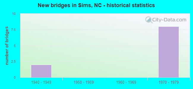
- New bridges - historical statistics
- 21940-1949
- 81970-1979


- Bridge Condition - Deck
- 75.0%Good
- 25.0%Satisfactory

- Bridge Condition - Superstructure
- 50.0%Good
- 50.0%Satisfactory

- Bridge Condition - Substructure
- 25.0%Good
- 75.0%Satisfactory
Find on map >> Show street view
Structure Number: 1270064, Location: 0.2 MI W. OF JCT SR1945 (Lat: 35.809461, Lng: -78.048100), Route carried "on" structure: State highway 1941, Year Built: 1947, Year Reconstructed: 1974, Status: Open, Structure Length: 1.28m (4.20ft), Average Daily Traffic: 2,300 (year 2017), Truck Traffic: 6%, Average Future Daily Traffic: 4,600 (year 2040), Design Load: HS 15, Features Intersected: BEAVERDAM CREEK
Minimum Vertical Clearance: 30+ m (98+ ft), Kilometerpoint: 0.000, Lanes on structure: 2, Owner: State Highway Agency, Approaching Roadway Width: 5.4m (17.7ft), Material/Design: Steel, Design/Construction: Stringer/Multi-beam, Number Of Spans In Main Unit: 1, Length of Maximum Span: 11.8m (38.7ft), Curb-To-Curb Width: 8.5m (27.9ft), Out-to-Out Width: 8.5m (27.9ft)
Condition: Deck: Satisfactory, Superstructure: Satisfactory, Substructure: Satisfactory, Channel: Good, Operating Rating: 43.5 metric tons, Method Used To Determine Operating Rating: Load Factor (LF), Inventory Rating: 26.3 metric tons, Method Used To Determine Inventory Rating: Load Factor (LF), Structural Evaluation: Equal to present minimum criteria, Deck Geometry: Meets minimum limits, Waterway Adequacy: Better than present minimum criteria, Approach Roadway Alignment: Equal to present desirable criteria, Designated Inspection Frequency: Every 24 months, Inspection Date: April 2020, Deck Structure Type: Corrugated Steel, Wearing Surface/Protective System: Wearing Surface: Bituminous
Find on map >> Show street view
Structure Number: 1270212, Location: 0.3 MI.S. OF SR1945 (Lat: 35.777631, Lng: -78.073192), Route carried "on" structure: State highway 1965, Year Built: 1977, Status: Open, Structure Length: 8.10m (26.57ft), Average Daily Traffic: 310 (year 2017), Truck Traffic: 6%, Average Future Daily Traffic: 620 (year 2040), Design Load: HS 15, Features Intersected: US264
Minimum Vertical Clearance: 30+ m (98+ ft), Kilometerpoint: 0.000, Lanes on structure: 2, Lanes under structure: 8, Owner: State Highway Agency, Approaching Roadway Width: 6.7m (22.0ft), Skew: 1 degrees, Material/Design: Steel, Design/Construction: Stringer/Multi-beam, Number Of Spans In Main Unit: 2, Length of Maximum Span: 40.2m (131.9ft), Curb-To-Curb Width: 9.1m (29.9ft), Out-to-Out Width: 10.0m (32.8ft)
Condition: Deck: Good, Superstructure: Good, Substructure: Good, Operating Rating: 89.8 metric tons, Method Used To Determine Operating Rating: Load Factor (LF), Inventory Rating: 56.2 metric tons, Method Used To Determine Inventory Rating: Load Factor (LF), Structural Evaluation: Better than present minimum criteria, Deck Geometry: Equal to present minimum criteria, Underclear: Equal to present minimum criteria, Approach Roadway Alignment: Equal to present desirable criteria, Designated Inspection Frequency: Every 24 months, Inspection Date: June 2020, Deck Structure Type: Concrete Cast-file-Place, Wearing Surface/Protective System: Wearing Surface: Monolithic Concrete
Find on map >> Show street view
Structure Number: 1950004, Location: 0.2 MI. N. OF SR1385 (Lat: 35.774033, Lng: -78.057644), Route carried "on" structure: State highway 1301, Year Built: 1978, Status: Open, Structure Length: 7.55m (24.77ft), Average Daily Traffic: 1,300 (year 2019), Truck Traffic: 6%, Average Future Daily Traffic: 2,600 (year 2040), Design Load: HS 15, Features Intersected: US-264
Minimum Vertical Clearance: 30+ m (98+ ft), Kilometerpoint: 10.363, Lanes on structure: 3, Lanes under structure: 4, Owner: State Highway Agency, Approaching Roadway Width: 6.0m (19.7ft), Material/Design: Steel, Design/Construction: Stringer/Multi-beam, Number Of Spans In Main Unit: 2, Number Of Approach Spans: 2, Length of Maximum Span: 37.4m (122.7ft), Curb-To-Curb Width: 18.2m (59.7ft), Out-to-Out Width: 19.1m (62.7ft)
Condition: Deck: Good, Superstructure: Good, Substructure: Satisfactory, Operating Rating: 89.8 metric tons, Method Used To Determine Operating Rating: Load Factor (LF), Inventory Rating: 58.0 metric tons, Method Used To Determine Inventory Rating: Load Factor (LF), Structural Evaluation: Equal to present minimum criteria, Deck Geometry: Superior to present desirable criteria, Underclear: Equal to present minimum criteria, Approach Roadway Alignment: Equal to present desirable criteria, Designated Inspection Frequency: Every 24 months, Inspection Date: September 2021, Deck Structure Type: Concrete Cast-file-Place, Wearing Surface/Protective System: Wearing Surface: Monolithic Concrete
Find on map >> Show street view
Structure Number: 1950049, Location: 0.1 MI. N. JCT. SR1142 (Lat: 35.703781, Lng: -78.066567), Route carried "on" structure: State highway 1149, Year Built: 1948, Year Reconstructed: 1966, Status: Posted for load, Structure Length: 1.31m (4.30ft), Average Daily Traffic: 1,000 (year 2018), Truck Traffic: 6%, Average Future Daily Traffic: 2,000 (year 2040), Features Intersected: MARSH SWAMP
Minimum Vertical Clearance: 30+ m (98+ ft), Kilometerpoint: 0.000, Lanes on structure: 2, Owner: State Highway Agency, Approaching Roadway Width: 6.0m (19.7ft), Material/Design: Steel, Design/Construction: Stringer/Multi-beam, Number Of Spans In Main Unit: 1, Length of Maximum Span: 12.4m (40.7ft), Curb or Sidewalk Widths: Left: 0.4m (1.3ft), Right: 0.4m (1.3ft), Curb-To-Curb Width: 8.5m (27.9ft), Out-to-Out Width: 10.3m (33.8ft)
Condition: Deck: Good, Superstructure: Satisfactory, Substructure: Satisfactory, Channel: Good, Operating Rating: 36.2 metric tons, Method Used To Determine Operating Rating: Load Factor (LF), Inventory Rating: 21.7 metric tons, Method Used To Determine Inventory Rating: Load Factor (LF), Structural Evaluation: Somewhat better than minimum adequacy, Deck Geometry: Somewhat better than minimum adequacy, Waterway Adequacy: Better than present minimum criteria, Approach Roadway Alignment: Equal to present desirable criteria, Bridge Posting: Required (Relationship of Operating Rating to Maximum Legal Load: 10.0 - 19.9% below), Designated Inspection Frequency: Every 24 months, Inspection Date: October 2020, Deck Structure Type: Concrete Cast-file-Place, Wearing Surface/Protective System: Wearing Surface: Bituminous
Find on map >> Show street view
Structure Number: 1270212, Location: 0.3 MI.S. OF SR1945 (Lat: 35.777631, Lng: -78.073192), Route carried "under" structure: US 264, Year Built: 1977, Structure Length: 0. m, Average Daily Traffic: 15,000 (year 2018), Truck Traffic: 14%, Features Intersected: SR1965
Minimum Vertical Clearance: 5.08m (16.67ft), Kilometerpoint: 10.089, Lanes on structure: 2, Lanes under structure: 2, Material/Design: Steel, Design/Construction: Stringer/Multi-beam, Length of Maximum Span: 40.2m (131.9ft)
Find on map >> Show street view
Structure Number: 1270212, Location: 0.3 MI.S. OF SR1945 (Lat: 35.777631, Lng: -78.073192), Route carried "under" structure: US 264, Year Built: 1977, Structure Length: 0. m, Average Daily Traffic: 11,000 (year 2012), Truck Traffic: 14%, Features Intersected: SR1965
Minimum Vertical Clearance: 5.15m (16.90ft), Kilometerpoint: 10.089, Lanes on structure: 2, Lanes under structure: 2, Material/Design: Steel, Design/Construction: Stringer/Multi-beam, Length of Maximum Span: 40.2m (131.9ft)
Find on map >> Show street view
Structure Number: 1270212, Location: 0.3 MI.S. OF SR1945 (Lat: 35.777631, Lng: -78.073192), Route carried "under" structure: US 264, Year Built: 1977, Structure Length: 0. m, Average Daily Traffic: 11,000 (year 2012), Truck Traffic: 14%, Features Intersected: SR1965
Minimum Vertical Clearance: 5.23m (17.16ft), Kilometerpoint: 10.089, Lanes on structure: 2, Lanes under structure: 2, Material/Design: Steel, Design/Construction: Stringer/Multi-beam, Length of Maximum Span: 40.2m (131.9ft)
Find on map >> Show street view
Structure Number: 1270212, Location: 0.3 MI.S. OF SR1945 (Lat: 35.777631, Lng: -78.073192), Route carried "under" structure: US 264, Year Built: 1977, Structure Length: 0. m, Average Daily Traffic: 15,000 (year 2018), Truck Traffic: 14%, Features Intersected: SR1965
Minimum Vertical Clearance: 5.08m (16.67ft), Kilometerpoint: 10.089, Lanes on structure: 2, Lanes under structure: 2, Material/Design: Steel, Design/Construction: Stringer/Multi-beam, Length of Maximum Span: 40.2m (131.9ft)
Find on map >> Show street view
Structure Number: 1950004, Location: 0.2 MI. N. OF SR1385 (Lat: 35.774033, Lng: -78.057644), Route carried "under" structure: US 264, Year Built: 1978, Structure Length: 0. m, Average Daily Traffic: 15,000 (year 2018), Truck Traffic: 14%, Features Intersected: SR1301
Minimum Vertical Clearance: 4.95m (16.24ft), Kilometerpoint: 10.363, Lanes on structure: 3, Lanes under structure: 2, Material/Design: Steel, Design/Construction: Stringer/Multi-beam, Length of Maximum Span: 37.4m (122.7ft)
Find on map >> Show street view
Structure Number: 1950004, Location: 0.2 MI. N. OF SR1385 (Lat: 35.774033, Lng: -78.057644), Route carried "under" structure: US 264, Year Built: 1978, Structure Length: 0. m, Average Daily Traffic: 15,000 (year 2018), Truck Traffic: 14%, Features Intersected: SR1301
Minimum Vertical Clearance: 5.00m (16.40ft), Kilometerpoint: 10.363, Lanes on structure: 3, Lanes under structure: 2, Material/Design: Steel, Design/Construction: Stringer/Multi-beam, Length of Maximum Span: 37.4m (122.7ft)