Bridge Statistics for Skowhegan, Maine (ME)
Condition, Traffic, Stress, Structural Evaluation, Project Costs
- National Bridge Inventory (NBI) Statistics
- 22Number of bridges
- 154ft / 46.8mTotal length
- 148,191Total average daily traffic
- 11,521Total average daily truck traffic
- National Bridge Inventory (NBI) Registered Bridges for Skowhegan
- No street view available for this location
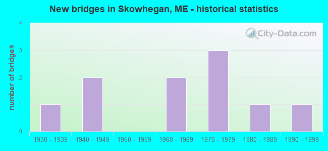
- New bridges - historical statistics
- 11930-1939
- 21940-1949
- 21960-1969
- 31970-1979
- 11980-1989
- 11990-1999
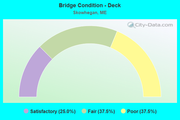
- Bridge Condition - Deck
- 25.0%Satisfactory
- 37.5%Fair
- 37.5%Poor
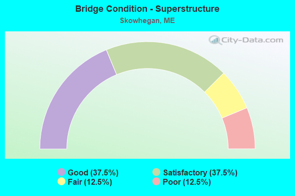
- Bridge Condition - Superstructure
- 37.5%Good
- 37.5%Satisfactory
- 12.5%Fair
- 12.5%Poor
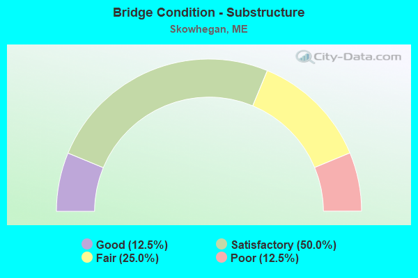
- Bridge Condition - Substructure
- 12.5%Good
- 50.0%Satisfactory
- 25.0%Fair
- 12.5%Poor
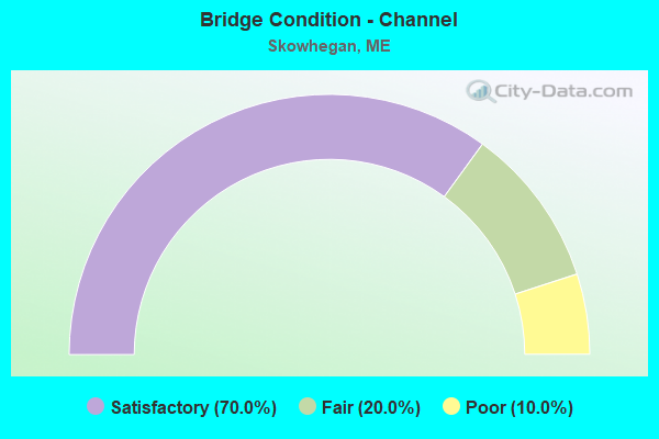
- Bridge Condition - Channel
- 70.0%Satisfactory
- 20.0%Fair
- 10.0%Poor
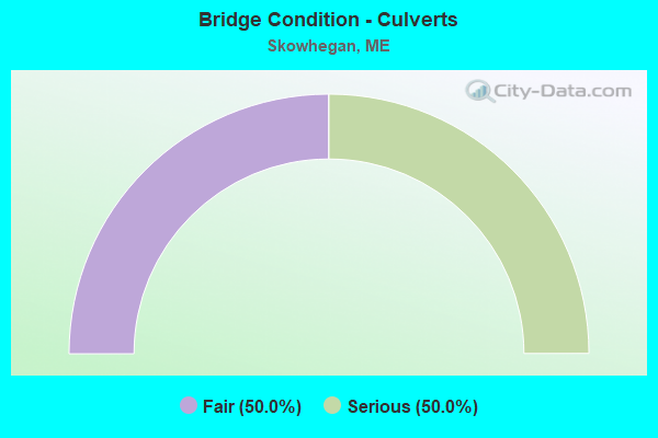
- Bridge Condition - Culverts
- 50.0%Fair
- 50.0%Serious
Find on map >> Show street view
Structure Number: 1084, Location: 1 MI N RT 150 (Lat: 44.798011, Lng: -69.713739), Route carried "on" structure: City street , Year Built: 1978, Status: Posted for load, Structure Length: 0.73m (2.40ft), Average Daily Traffic: 63 (year 2016), Truck Traffic: 5%, Average Future Daily Traffic: 101 (year 2036), Features Intersected: COLD BK, Facility Carried by Structure: STEWART HILL RD
Minimum Vertical Clearance: 30+ m (98+ ft), Kilometerpoint: 1.175, Lanes on structure: 2, Owner: Town or Township Highway Agency, Approaching Roadway Width: 6.1m (20.0ft), Material/Design: Steel, Design/Construction: Culvert, Number Of Spans In Main Unit: 2, Length of Maximum Span: 5.2m (17.1ft)
Condition: Channel: Poor, Culverts: Serious, Operating Rating: 9.1 metric tons, Method Used To Determine Operating Rating: Field evaluation and documented engineering judgment, Inventory Rating: 9.1 metric tons, Method Used To Determine Inventory Rating: Field evaluation and documented engineering judgment, Structural Evaluation: High priority of corrective action, Waterway Adequacy: Somewhat better than minimum adequacy, Approach Roadway Alignment: Equal to present desirable criteria, Bridge Posting: Required (Relationship of Operating Rating to Maximum Legal Load: 10.0 - 19.9% below), Designated Inspection Frequency: Every 12 months, Underwater Inspection Frequency: Every 60 months, Inspection Date: May 2021, Underwater Inspection Date: May 2019
Find on map >> Show street view
Structure Number: 2508, Location: 0.2 MI N OF JCT RTE 23 (Lat: 44.689919, Lng: -69.629189), Route carried "on" structure: City street , Year Built: 1930, Status: Open, Structure Length: 1.65m (5.41ft), Average Daily Traffic: 1,331 (year 2016), Truck Traffic: 5%, Average Future Daily Traffic: 1,997 (year 2036), Design Load: H 20, Features Intersected: CARRABASSETT STREAM, Facility Carried by Structure: RIVER ROAD
Minimum Vertical Clearance: 30+ m (98+ ft), Kilometerpoint: 0.000, Lanes on structure: 2, Owner: State Highway Agency, Approaching Roadway Width: 6.7m (22.0ft), Material/Design: Concrete, Design/Construction: Slab, Number Of Spans In Main Unit: 3, Length of Maximum Span: 4.6m (15.1ft), Curb-To-Curb Width: 6.1m (20.0ft), Out-to-Out Width: 7.0m (23.0ft)
Condition: Deck: Poor, Superstructure: Poor, Substructure: Poor, Channel: Satisfactory, Operating Rating: 30.8 metric tons, Method Used To Determine Operating Rating: Load and Resistance Factor Rating (LRFR) rating reported by rating factor(RF) method using HL-93 loadings, Inventory Rating: 23.7 metric tons, Method Used To Determine Inventory Rating: Load and Resistance Factor Rating (LRFR) rating reported by rating factor(RF) method using HL-93 loadings, Structural Evaluation: Meets minimum limits, Deck Geometry: High priority of replacement, Waterway Adequacy: Better than present minimum criteria, Approach Roadway Alignment: Equal to present desirable criteria, Designated Inspection Frequency: Every 24 months, Underwater Inspection Frequency: Every 60 months, Inspection Date: March 2021, Underwater Inspection Date: September 2020, Deck Structure Type: Concrete Cast-file-Place, Wearing Surface/Protective System: Wearing Surface: Bituminous
Find on map >> Show street view
Structure Number: 2785, Location: JCT 2&201 (Lat: 44.763189, Lng: -69.718219), Route carried "on" structure: State highway 2, Year Built: 1976, Status: Open, Structure Length: 7.00m (22.97ft), Average Daily Traffic: 21,774 (year 2016), Truck Traffic: 5%, Average Future Daily Traffic: 30,484 (year 2036), Design Load: HS 20, Features Intersected: KENNEBEC RIVER
Minimum Vertical Clearance: 30+ m (98+ ft), Kilometerpoint: 148.140, Lanes on structure: 3, Base Highway Network: Yes, Owner: State Highway Agency, Approaching Roadway Width: 11.0m (36.1ft), Material/Design: Steel continuous, Design/Construction: Stringer/Multi-beam, Number Of Spans In Main Unit: 2, Length of Maximum Span: 34.4m (112.9ft), Curb or Sidewalk Widths: Left: 1.5m (4.9ft), Right: 1.5m (4.9ft), Curb-To-Curb Width: 11.1m (36.4ft), Out-to-Out Width: 15.0m (49.2ft)
Condition: Deck: Fair, Superstructure: Good, Substructure: Satisfactory, Channel: Satisfactory, Operating Rating: 38.6 metric tons, Method Used To Determine Operating Rating: Load and Resistance Factor Rating (LRFR) rating reported by rating factor(RF) method using HL-93 loadings, Inventory Rating: 29.8 metric tons, Method Used To Determine Inventory Rating: Load and Resistance Factor Rating (LRFR) rating reported by rating factor(RF) method using HL-93 loadings, Structural Evaluation: Equal to present minimum criteria, Deck Geometry: High priority of replacement, Waterway Adequacy: Better than present minimum criteria, Approach Roadway Alignment: Equal to present desirable criteria, Designated Inspection Frequency: Every 24 months, Underwater Inspection Frequency: Every 60 months, Inspection Date: November 2021, Underwater Inspection Date: October 2021, Deck Structure Type: Concrete Cast-file-Place, Wearing Surface/Protective System: Wearing Surface: Integral Concrete
Find on map >> Show street view
Structure Number: 2924, Location: 2.4 MI E JCT RTE 150 (Lat: 44.771061, Lng: -69.677839), Route carried "on" structure: State highway 2, Year Built: 1942, Status: Open, Structure Length: 7.13m (23.39ft), Average Daily Traffic: 5,922 (year 2016), Truck Traffic: 5%, Average Future Daily Traffic: 8,291 (year 2036), Design Load: H 15, Features Intersected: WESSERUNSETT STREAM
Minimum Vertical Clearance: 30+ m (98+ ft), Kilometerpoint: 152.437, Lanes on structure: 2, Base Highway Network: Yes, Owner: State Highway Agency, Approaching Roadway Width: 9.4m (30.8ft), Material/Design: Steel, Design/Construction: Stringer/Multi-beam, Number Of Spans In Main Unit: 3, Length of Maximum Span: 27.4m (89.9ft), Curb or Sidewalk Widths: Left: 0.2m (0.7ft), Right: 0.2m (0.7ft), Curb-To-Curb Width: 8.9m (29.2ft), Out-to-Out Width: 10.1m (33.1ft)
Condition: Deck: Fair, Superstructure: Fair, Substructure: Fair, Channel: Satisfactory, Operating Rating: 33.4 metric tons, Method Used To Determine Operating Rating: Load and Resistance Factor Rating (LRFR) rating reported by rating factor(RF) method using HL-93 loadings, Inventory Rating: 25.9 metric tons, Method Used To Determine Inventory Rating: Load and Resistance Factor Rating (LRFR) rating reported by rating factor(RF) method using HL-93 loadings, Structural Evaluation: Somewhat better than minimum adequacy, Deck Geometry: Meets minimum limits, Waterway Adequacy: Equal to present minimum criteria, Approach Roadway Alignment: Equal to present desirable criteria, Designated Inspection Frequency: Every 24 months, Other Special Inspection Frequency: Every 60 months, Inspection Date: November 2021, Other Special Inspection Date: May 2021, Deck Structure Type: Concrete Cast-file-Place, Wearing Surface/Protective System: Wearing Surface: Integral Concrete
Find on map >> Show street view
Structure Number: 3389, Location: 0.1 MI E OF JCT RTE 201 (Lat: 44.685711, Lng: -69.630369), Route carried "on" structure: State highway 23, Year Built: 1983, Status: Open, Structure Length: 19.60m (64.30ft), Average Daily Traffic: 3,593 (year 2016), Truck Traffic: 5%, Average Future Daily Traffic: 5,030 (year 2036), Design Load: H 20, Features Intersected: KENNEBEC RIVER
Minimum Vertical Clearance: 30+ m (98+ ft), Kilometerpoint: 37.691, Lanes on structure: 2, Owner: State Highway Agency, Approaching Roadway Width: 10.1m (33.1ft), Material/Design: Steel continuous, Design/Construction: Stringer/Multi-beam, Number Of Spans In Main Unit: 4, Length of Maximum Span: 93.0m (305.1ft), Curb or Sidewalk Widths: Left: 0.2m (0.7ft), Right: 0.2m (0.7ft), Curb-To-Curb Width: 10.1m (33.1ft), Out-to-Out Width: 11.2m (36.7ft)
Condition: Deck: Satisfactory, Superstructure: Good, Substructure: Good, Channel: Satisfactory, Operating Rating: 49.6 metric tons, Method Used To Determine Operating Rating: Load and Resistance Factor Rating (LRFR) rating reported by rating factor(RF) method using HL-93 loadings, Inventory Rating: 38.2 metric tons, Method Used To Determine Inventory Rating: Load and Resistance Factor Rating (LRFR) rating reported by rating factor(RF) method using HL-93 loadings, Structural Evaluation: Better than present minimum criteria, Deck Geometry: Meets minimum limits, Waterway Adequacy: Superior to present desirable criteria, Approach Roadway Alignment: Equal to present desirable criteria, Designated Inspection Frequency: Every 24 months, Underwater Inspection Frequency: Every 60 months, Inspection Date: September 2020, Underwater Inspection Date: June 2020, Deck Structure Type: Concrete Cast-file-Place, Wearing Surface/Protective System: Wearing Surface: Bituminous, Membrane: Preformed Fabric
Find on map >> Show street view
Structure Number: 3773, Location: 0.1 Mi N OFJCT NOTCH RD (Lat: 44.798431, Lng: -69.686069), Route carried "on" structure: County highway , Year Built: 1969, Status: Open, Structure Length: 2.59m (8.50ft), Average Daily Traffic: 639 (year 2016), Truck Traffic: 5%, Average Future Daily Traffic: 1,022 (year 2036), Design Load: H 20, Features Intersected: W BR WESSERUNSETT STREAM, Facility Carried by Structure: MALBONS MILLS ROAD
Minimum Vertical Clearance: 30+ m (98+ ft), Kilometerpoint: 3.492, Lanes on structure: 2, Owner: State Highway Agency, Approaching Roadway Width: 8.8m (28.9ft), Skew: 3 degrees, Material/Design: Steel, Design/Construction: Stringer/Multi-beam, Number Of Spans In Main Unit: 1, Length of Maximum Span: 24.4m (80.1ft), Curb or Sidewalk Widths: Left: 0.2m (0.7ft), Right: 0.2m (0.7ft), Curb-To-Curb Width: 8.5m (27.9ft), Out-to-Out Width: 9.6m (31.5ft)
Condition: Deck: Satisfactory, Superstructure: Satisfactory, Substructure: Satisfactory, Channel: Fair, Operating Rating: 43.7 metric tons, Method Used To Determine Operating Rating: Load and Resistance Factor Rating (LRFR) rating reported by rating factor(RF) method using HL-93 loadings, Inventory Rating: 33.7 metric tons, Method Used To Determine Inventory Rating: Load and Resistance Factor Rating (LRFR) rating reported by rating factor(RF) method using HL-93 loadings, Structural Evaluation: Equal to present minimum criteria, Deck Geometry: Somewhat better than minimum adequacy, Waterway Adequacy: Equal to present minimum criteria, Approach Roadway Alignment: Equal to present desirable criteria, Designated Inspection Frequency: Every 24 months, Inspection Date: April 2021, Deck Structure Type: Concrete Cast-file-Place, Wearing Surface/Protective System: Wearing Surface: Latex Concrete
Find on map >> Show street view
Structure Number: 3804, Location: 75 FT W OF E MADISON ROAD (Lat: 44.850361, Lng: -69.757050), Route carried "on" structure: City street , Year Built: 1945, Status: Open, Structure Length: 1.04m (3.41ft), Average Daily Traffic: 287 (year 2016), Truck Traffic: 5%, Average Future Daily Traffic: 459 (year 2036), Design Load: H 15, Features Intersected: W BR WESSERUNSETT STREAM, Facility Carried by Structure: LOWER MILLS RD
Minimum Vertical Clearance: 30+ m (98+ ft), Kilometerpoint: 0.016, Lanes on structure: 2, Owner: State Highway Agency, Approaching Roadway Width: 6.7m (22.0ft), Material/Design: Concrete, Design/Construction: Tee Beam, Number Of Spans In Main Unit: 1, Length of Maximum Span: 9.6m (31.5ft), Curb or Sidewalk Widths: Left: 0.2m (0.7ft), Right: 1.5m (4.9ft), Curb-To-Curb Width: 6.7m (22.0ft), Out-to-Out Width: 9.1m (29.9ft)
Condition: Deck: Fair, Superstructure: Satisfactory, Substructure: Satisfactory, Channel: Satisfactory, Operating Rating: 24.0 metric tons, Method Used To Determine Operating Rating: Load and Resistance Factor Rating (LRFR) rating reported by rating factor(RF) method using HL-93 loadings, Inventory Rating: 18.5 metric tons, Method Used To Determine Inventory Rating: Load and Resistance Factor Rating (LRFR) rating reported by rating factor(RF) method using HL-93 loadings, Structural Evaluation: Somewhat better than minimum adequacy, Deck Geometry: Meets minimum limits, Waterway Adequacy: Superior to present desirable criteria, Approach Roadway Alignment: Better than present minimum criteria, Designated Inspection Frequency: Every 24 months, Inspection Date: October 2021, Deck Structure Type: Concrete Cast-file-Place, Wearing Surface/Protective System: Wearing Surface: Bituminous
Find on map >> Show street view
Structure Number: 5335, Location: 250FT S OF LOWER MILLS RD (Lat: 44.849211, Lng: -69.756989), Route carried "on" structure: County highway , Year Built: 1991, Status: Open, Structure Length: 1.05m (3.44ft), Average Daily Traffic: 1,074 (year 2016), Truck Traffic: 5%, Average Future Daily Traffic: 1,611 (year 2036), Design Load: HS 25 or greater, Features Intersected: W.BR.WESSERUNSETT STREAM, Facility Carried by Structure: E MADISON RD
Minimum Vertical Clearance: 30+ m (98+ ft), Kilometerpoint: 7.113, Lanes on structure: 2, Owner: State Highway Agency, Approaching Roadway Width: 9.8m (32.2ft), Skew: 2 degrees, Material/Design: Steel, Design/Construction: Culvert, Number Of Spans In Main Unit: 2, Length of Maximum Span: 4.6m (15.1ft)
Condition: Channel: Satisfactory, Culverts: Fair, Operating Rating: 35.6 metric tons, Method Used To Determine Operating Rating: Load and Resistance Factor Rating (LRFR) rating reported by rating factor(RF) method using HL-93 loadings, Inventory Rating: 27.5 metric tons, Method Used To Determine Inventory Rating: Load and Resistance Factor Rating (LRFR) rating reported by rating factor(RF) method using HL-93 loadings, Structural Evaluation: Somewhat better than minimum adequacy, Waterway Adequacy: Equal to present desirable criteria, Approach Roadway Alignment: Equal to present desirable criteria, Designated Inspection Frequency: Every 24 months, Underwater Inspection Frequency: Every 60 months, Inspection Date: October 2021, Underwater Inspection Date: July 2019
Find on map >> Show street view
Structure Number: 6152, Location: .3 MI S TOWNLINE (Lat: 44.805631, Lng: -69.704689), Route carried "on" structure: State highway 150, Year Built: 1966, Status: Open, Structure Length: 3.54m (11.61ft), Average Daily Traffic: 3,038 (year 2016), Truck Traffic: 5%, Average Future Daily Traffic: 4,253 (year 2036), Design Load: HS 20, Features Intersected: W BR WESSERUNSETT STREAM
Minimum Vertical Clearance: 30+ m (98+ ft), Kilometerpoint: 4.651, Lanes on structure: 2, Owner: State Highway Agency, Approaching Roadway Width: 10.4m (34.1ft), Skew: 5 degrees, Material/Design: Steel, Design/Construction: Stringer/Multi-beam, Number Of Spans In Main Unit: 1, Length of Maximum Span: 34.4m (112.9ft), Curb or Sidewalk Widths: Left: 0.5m (1.6ft), Right: 0.5m (1.6ft), Curb-To-Curb Width: 8.5m (27.9ft), Out-to-Out Width: 10.2m (33.5ft)
Condition: Deck: Poor, Superstructure: Satisfactory, Substructure: Fair, Channel: Fair, Operating Rating: 55.7 metric tons, Method Used To Determine Operating Rating: Load and Resistance Factor Rating (LRFR) rating reported by rating factor(RF) method using HL-93 loadings, Inventory Rating: 42.8 metric tons, Method Used To Determine Inventory Rating: Load and Resistance Factor Rating (LRFR) rating reported by rating factor(RF) method using HL-93 loadings, Structural Evaluation: Somewhat better than minimum adequacy, Deck Geometry: Meets minimum limits, Waterway Adequacy: Superior to present desirable criteria, Approach Roadway Alignment: Equal to present desirable criteria, Designated Inspection Frequency: Every 24 months, Inspection Date: April 2021, Deck Structure Type: Concrete Cast-file-Place, Wearing Surface/Protective System: Wearing Surface: Integral Concrete
Find on map >> Show street view
Structure Number: 6215, Location: .1 MI E MALBONS MILL RD (Lat: 44.796181, Lng: -69.684350), Route carried "on" structure: City street , Year Built: 1972, Status: Open, Structure Length: 2.47m (8.10ft), Average Daily Traffic: 649 (year 2016), Truck Traffic: 5%, Average Future Daily Traffic: 1,038 (year 2036), Design Load: H 20, Features Intersected: WESSERUNSETT STREAM, Facility Carried by Structure: NOTCH RD
Minimum Vertical Clearance: 30+ m (98+ ft), Kilometerpoint: 3.862, Lanes on structure: 2, Owner: Town or Township Highway Agency, Approaching Roadway Width: 8.5m (27.9ft), Skew: 1 degrees, Material/Design: Steel, Design/Construction: Stringer/Multi-beam, Number Of Spans In Main Unit: 1, Length of Maximum Span: 23.7m (77.8ft), Curb or Sidewalk Widths: Left: 0.2m (0.7ft), Right: 0.2m (0.7ft), Curb-To-Curb Width: 8.5m (27.9ft), Out-to-Out Width: 9.4m (30.8ft)
Condition: Deck: Poor, Superstructure: Good, Substructure: Satisfactory, Channel: Satisfactory, Operating Rating: 45.0 metric tons, Method Used To Determine Operating Rating: Load and Resistance Factor Rating (LRFR) rating reported by rating factor(RF) method using HL-93 loadings, Inventory Rating: 35.0 metric tons, Method Used To Determine Inventory Rating: Load and Resistance Factor Rating (LRFR) rating reported by rating factor(RF) method using HL-93 loadings, Structural Evaluation: Equal to present minimum criteria, Deck Geometry: Somewhat better than minimum adequacy, Waterway Adequacy: Superior to present desirable criteria, Approach Roadway Alignment: Equal to present desirable criteria, Designated Inspection Frequency: Every 24 months, Inspection Date: October 2020, Deck Structure Type: Concrete Cast-file-Place, Wearing Surface/Protective System: Wearing Surface: Latex Concrete
Find on map >> Show street view
Location: INTERCHANGE 182 (Lat: 44.786975, Lng: -69.620628), Route carried "on" structure: Alternate County highway 82310, Structure Length: 0. m, Average Daily Traffic: 19,173 (year 2014), Truck Traffic: 10%, Features Intersected: I-95 SOUTHBOUND, Facility Carried by Structure: INDUSTRIAL SPUR (I
Minimum Vertical Clearance: 4.47m (14.67ft), Kilometerpoint: 0.338, Lanes on structure: 6, Length of Maximum Span: 0.0m
Find on map >> Show street view
Location: .1 MI SO TOWNLINE (Lat: 44.866431, Lng: -69.640883), Route carried "under" structure: County highway 32310, Structure Length: 0. m, Average Daily Traffic: 8,580 (year 2014), Truck Traffic: 5%, Features Intersected: BANGOR & AROOSTOOK, Facility Carried by Structure: BROADWAY - ROUTE 1
Minimum Vertical Clearance: 4.52m (14.83ft), Kilometerpoint: 109.596, Lanes on structure: 2, Length of Maximum Span: 0.0m
Find on map >> Show street view
Location: .5 MI W TOWNLN ON US2&100 (Lat: 44.791953, Lng: -69.656347), Route carried "under" structure: Alternate County highway 2310, Structure Length: 0. m, Average Daily Traffic: 7,770 (year 2014), Truck Traffic: 8%, Features Intersected: BANGOR & AROOSTOOK, Facility Carried by Structure: ROUTE #100 & US 2
Minimum Vertical Clearance: 4.85m (15.91ft), Kilometerpoint: 222.781, Lanes on structure: 2, Length of Maximum Span: 0.0m
Find on map >> Show street view
Location: .5 MI W TOWNLINE (Lat: 44.792222, Lng: -69.680256), Route carried "under" structure: Alternate County highway 12310, Structure Length: 0. m, Average Daily Traffic: 7,770 (year 2014), Truck Traffic: 8%, Features Intersected: BANGOR & AROOSTOOK, Facility Carried by Structure: ROUTE #100 & US #2
Minimum Vertical Clearance: 4.70m (15.42ft), Kilometerpoint: 223.136, Lanes on structure: 2, Length of Maximum Span: 0.0m
Find on map >> Show street view
Location: .3 MI E TOWNLINE ON RT222 (Lat: 44.834603, Lng: -69.696497), Route carried "under" structure: Alternate County highway 22410, Structure Length: 0. m, Average Daily Traffic: 8,290 (year 2014), Truck Traffic: 5%, Features Intersected: BANGOR & AROOSTOOK, Facility Carried by Structure: UNION ST - ROUTE 2
Minimum Vertical Clearance: 4.48m (14.70ft), Kilometerpoint: 37.530, Lanes on structure: 2, Length of Maximum Span: 0.0m
Find on map >> Show street view
Location: INTERCHANGE #47 (Lat: 44.808811, Lng: -69.628097), Route carried "under" structure: State lands road 72310, Structure Length: 0. m, Average Daily Traffic: 18,780 (year 2014), Truck Traffic: 10%, Features Intersected: ROUTE 222, Facility Carried by Structure: INTERSTATE 95
Minimum Vertical Clearance: 4.60m (15.09ft), Kilometerpoint: 293.931, Lanes on structure: 4, Length of Maximum Span: 0.0m
Find on map >> Show street view
Location: 0.2 MI W OF 95 / I-395 (Lat: 44.783817, Lng: -69.740647), Route carried "under" structure: Ramp 22400, Structure Length: 0. m, Average Daily Traffic: 4,110 (year 2014), Truck Traffic: 5%, Features Intersected: I-95 NORTHBOUND, Facility Carried by Structure: M C RR & PERRY ROA
Minimum Vertical Clearance: 7.60m (24.93ft), Kilometerpoint: 1.899, Lanes on structure: 2, Length of Maximum Span: 0.0m
Find on map >> Show street view
Location: 0.7 MI NW OF BURNHAM (Lat: 44.705181, Lng: -69.715750), Route carried "under" structure: Service 22310, Structure Length: 0. m, Average Daily Traffic: 8,550 (year 2014), Truck Traffic: 11%, Features Intersected: JOHNSONS FLAT ROAD, Facility Carried by Structure: INTERSTATE 95
Minimum Vertical Clearance: 4.93m (16.17ft), Kilometerpoint: 228.865, Lanes on structure: 4, Length of Maximum Span: 0.0m
Find on map >> Show street view
Location: 1.5 MI N'LY OF 11 & 100 (Lat: 44.736158, Lng: -69.706839), Route carried "under" structure: Service 32310, Structure Length: 0. m, Average Daily Traffic: 8,550 (year 2014), Truck Traffic: 11%, Features Intersected: SNAKEROOT ROAD, Facility Carried by Structure: INTERSTATE 95
Minimum Vertical Clearance: 5.03m (16.50ft), Kilometerpoint: 232.711, Lanes on structure: 4, Length of Maximum Span: 0.0m
Find on map >> Show street view
Location: 5.7 MI N TOWNLINE (Lat: 44.769681, Lng: -69.704664), Route carried "under" structure: Service 42500, Structure Length: 0. m, Average Daily Traffic: 354 (year 2014), Truck Traffic: 5%, Features Intersected: I-95 NORTHBOUND, Facility Carried by Structure: WEBB ROAD
Minimum Vertical Clearance: 4.77m (15.65ft), Kilometerpoint: 3.283, Lanes on structure: 2, Length of Maximum Span: 0.0m
Find on map >> Show street view
Location: 0.2 MI S OF JCT I-395 (Lat: 44.784172, Lng: -69.655906), Route carried "under" structure: Service 12400, Structure Length: 0. m, Average Daily Traffic: 3,250 (year 2014), Truck Traffic: 5%, Features Intersected: ROUTE US202, Facility Carried by Structure: PERRY ROAD
Minimum Vertical Clearance: 4.32m (14.17ft), Kilometerpoint: 0.515, Lanes on structure: 2, Length of Maximum Span: 0.0m
Find on map >> Show street view
Location: I-395 INTERCHANGE 2 (Lat: 44.786708, Lng: -69.640692), Route carried "under" structure: Service 22310, Structure Length: 0. m, Average Daily Traffic: 14,644 (year 2014), Truck Traffic: 10%, Features Intersected: ROUTE US 202, Facility Carried by Structure: INTERSTATE 395
Minimum Vertical Clearance: 5.00m (16.40ft), Kilometerpoint: 1.481, Lanes on structure: 5, Length of Maximum Span: 0.0m