Bridge Statistics for Sloatsburg, New York (NY)
Condition, Traffic, Stress, Structural Evaluation, Project Costs
- National Bridge Inventory (NBI) Statistics
- 15Number of bridges
- 112ft / 33.5mTotal length
- $45,756,000Total costs
- 216,867Total average daily traffic
- 12,909Total average daily truck traffic
- National Bridge Inventory (NBI) Registered Bridges for Sloatsburg
- No street view available for this location
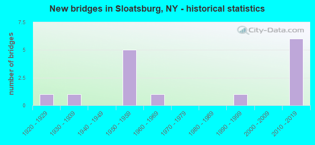
- New bridges - historical statistics
- 11920-1929
- 11930-1939
- 51950-1959
- 11960-1969
- 11990-1999
- 62010-2019

- Reconstructed bridges - Historical Statistics
- 12010-2019
- 12020-2022


- Bridge Condition - Deck
- 11.1%Very good
- 33.3%Good
- 44.4%Satisfactory
- 11.1%Fair

- Bridge Condition - Superstructure
- 30.0%Excellent
- 10.0%Very good
- 40.0%Satisfactory
- 20.0%Fair

- Bridge Condition - Substructure
- 10.0%Excellent
- 10.0%Very good
- 40.0%Good
- 30.0%Satisfactory
- 10.0%Fair

- Bridge Condition - Channel
- 30.0%Good
- 50.0%Satisfactory
- 20.0%Fair
Find on map >> Show street view
Structure Number: 101406, Location: 2.2 MI N JCT RTS 17+59 (Lat: 41.154183, Lng: -74.193442), Route carried "on" structure: State highway 17, Year Built: 1939, Status: Open, Structure Length: 1.34m (4.40ft), Average Daily Traffic: 16,524 (year 2017), Truck Traffic: 1%, Average Future Daily Traffic: 20,073 (year 2040), Design Load: H 20, Features Intersected: NAKAMA CREEK
Minimum Vertical Clearance: 30+ m (98+ ft), Kilometerpoint: 2.767, Lanes on structure: 5, Base Highway Network: Yes, Owner: State Highway Agency, Approaching Roadway Width: 16.5m (54.1ft), Material/Design: Concrete continuous, Design/Construction: Culvert, Number Of Spans In Main Unit: 3, Length of Maximum Span: 4.0m (13.1ft), Curb or Sidewalk Widths: Left: 1.6m (5.2ft), Right: 1.6m (5.2ft), Curb-To-Curb Width: 16.5m (54.1ft), Out-to-Out Width: 20.3m (66.6ft)
Condition: Channel: Fair, Culverts: Fair, Operating Rating: 51.7 metric tons, Method Used To Determine Operating Rating: Load Factor (LF), Inventory Rating: 30.8 metric tons, Method Used To Determine Inventory Rating: Load Factor (LF), Structural Evaluation: Somewhat better than minimum adequacy, Deck Geometry: High priority of replacement, Waterway Adequacy: Superior to present desirable criteria, Approach Roadway Alignment: Equal to present desirable criteria, Length Of Structure Improvement: 1.34m (4.40ft), Designated Inspection Frequency: Every 24 months, Inspection Date: July 2020, Bridge Improvement Cost: $768,000, Roadway Improvement Cost: $450,000, Total Project Cost: $1,218,000 ( Estimate for 2021), Wearing Surface/Protective System: Wearing Surface: Bituminous
Find on map >> Show street view
Structure Number: 105041, Location: IN SLOATSBURG (Lat: 41.161025, Lng: -74.191406), Route carried "on" structure: Other road 981G, Year Built: 1950, Status: Open, Structure Length: 2.59m (8.50ft), Average Daily Traffic: 3,999 (year 2016), Truck Traffic: 5%, Average Future Daily Traffic: 4,857 (year 2040), Design Load: H 20, Features Intersected: MNRR PJ LINE
Minimum Vertical Clearance: 30+ m (98+ ft), Kilometerpoint: 0.016, Lanes on structure: 2, Base Highway Network: Yes, Owner: State Highway Agency, Approaching Roadway Width: 8.5m (27.9ft), Material/Design: Concrete continuous, Design/Construction: Frame, Number Of Spans In Main Unit: 2, Length of Maximum Span: 11.8m (38.7ft), Curb or Sidewalk Widths: Left: 1.5m (4.9ft), Right: 1.5m (4.9ft), Curb-To-Curb Width: 8.5m (27.9ft), Out-to-Out Width: 12.2m (40.0ft)
Condition: Deck: Satisfactory, Superstructure: Satisfactory, Substructure: Fair, Operating Rating: 59.9 metric tons, Method Used To Determine Operating Rating: Field evaluation and documented engineering judgment, Inventory Rating: 22.8 metric tons, Method Used To Determine Inventory Rating: Field evaluation and documented engineering judgment, Structural Evaluation: Somewhat better than minimum adequacy, Deck Geometry: Meets minimum limits, Underclear: Meets minimum limits, Approach Roadway Alignment: Meets minimum limits, Length Of Structure Improvement: 2.59m (8.50ft), Designated Inspection Frequency: Every 24 months, Inspection Date: August 2020, Bridge Improvement Cost: $2,350,000, Roadway Improvement Cost: $1,376,000, Total Project Cost: $3,726,000 ( Estimate for 2021), Wearing Surface/Protective System: Wearing Surface: Bituminous
Find on map >> Show street view
Structure Number: 105042, Location: 0.1MI E JCT RTE17+PARK RD (Lat: 41.161656, Lng: -74.189339), Route carried "on" structure: State highway 981G, Year Built: 1929, Status: Open, Structure Length: 2.01m (6.59ft), Average Daily Traffic: 3,999 (year 2016), Truck Traffic: 5%, Average Future Daily Traffic: 4,857 (year 2040), Features Intersected: RAMAPO RIVER
Minimum Vertical Clearance: 30+ m (98+ ft), Kilometerpoint: 0.209, Lanes on structure: 2, Base Highway Network: Yes, Owner: State Highway Agency, Approaching Roadway Width: 8.5m (27.9ft), Material/Design: Concrete continuous, Design/Construction: Arch - Deck, Number Of Spans In Main Unit: 2, Length of Maximum Span: 9.1m (29.9ft), Curb-To-Curb Width: 8.5m (27.9ft), Out-to-Out Width: 9.1m (29.9ft)
Condition: Superstructure: Satisfactory, Substructure: Satisfactory, Channel: Fair, Operating Rating: 46.7 metric tons, Method Used To Determine Operating Rating: Field evaluation and documented engineering judgment, Inventory Rating: 19.2 metric tons, Method Used To Determine Inventory Rating: Field evaluation and documented engineering judgment, Structural Evaluation: Somewhat better than minimum adequacy, Deck Geometry: Meets minimum limits, Waterway Adequacy: Meets minimum limits, Approach Roadway Alignment: Meets minimum limits, Length Of Structure Improvement: 2.01m (6.59ft), Designated Inspection Frequency: Every 24 months, Inspection Date: July 2020, Bridge Improvement Cost: $1,284,000, Roadway Improvement Cost: $752,000, Total Project Cost: $2,036,000 ( Estimate for 2021), Wearing Surface/Protective System: Wearing Surface: Bituminous
Find on map >> Show street view
Structure Number: 105043, Location: 0.2MI E JCT RTE17+PARK RD (Lat: 41.161872, Lng: -74.188775), Route carried "on" structure: State highway 981G, Year Built: 2011, Status: Open, Structure Length: 3.14m (10.30ft), Average Daily Traffic: 3,999 (year 2016), Truck Traffic: 5%, Average Future Daily Traffic: 4,857 (year 2040), Design Load: HL 93, Features Intersected: RAMAPO RIVER
Minimum Vertical Clearance: 30+ m (98+ ft), Kilometerpoint: 0.257, Lanes on structure: 2, Base Highway Network: Yes, Owner: State Highway Agency, Approaching Roadway Width: 7.9m (25.9ft), Material/Design: Steel, Design/Construction: Stringer/Multi-beam, Number Of Spans In Main Unit: 1, Length of Maximum Span: 30.5m (100.1ft), Curb or Sidewalk Widths: Left: 1.6m (5.2ft), Right: 1.6m (5.2ft), Curb-To-Curb Width: 7.9m (25.9ft), Out-to-Out Width: 11.7m (38.4ft)
Condition: Deck: Good, Superstructure: Very good, Substructure: Very good, Channel: Satisfactory, Inventory Rating: 73.5 metric tons, Method Used To Determine Inventory Rating: Load Factor (LF), Structural Evaluation: Equal to present desirable criteria, Deck Geometry: High priority of corrective action, Waterway Adequacy: Equal to present minimum criteria, Approach Roadway Alignment: Equal to present desirable criteria, Length Of Structure Improvement: 3.13m (10.27ft), Designated Inspection Frequency: Every 24 months, Inspection Date: October 2021, Bridge Improvement Cost: $1,535,000, Roadway Improvement Cost: $899,000, Total Project Cost: $2,433,000 ( Estimate for 2021), Deck Structure Type: Concrete Precast Panels, Wearing Surface/Protective System: Wearing Surface: Bituminous
Find on map >> Show street view
Structure Number: 334617, Location: .6 MILE N OF SLOATSBURG (Lat: 41.168058, Lng: -74.190786), Route carried "on" structure: Other road , Year Built: 1992, Status: Open, Structure Length: 5.00m (16.40ft), Average Daily Traffic: 490 (year 2018), Truck Traffic: 4%, Average Future Daily Traffic: 686 (year 2038), Design Load: HS 20, Features Intersected: RAMAPO RIVER, Facility Carried by Structure: WASHINGTON AVENUE
Minimum Vertical Clearance: 30+ m (98+ ft), Kilometerpoint: 0.064, Lanes on structure: 2, Owner: County Highway Agency, Approaching Roadway Width: 8.5m (27.9ft), Skew: 1 degrees, Material/Design: Prestressed concrete, Design/Construction: Box Beam or Girders - Multiple, Number Of Spans In Main Unit: 3, Length of Maximum Span: 24.3m (79.7ft), Curb or Sidewalk Widths: Left: 0.0m, Right: 1.5m (4.9ft), Curb-To-Curb Width: 7.9m (25.9ft), Out-to-Out Width: 10.2m (33.5ft)
Condition: Deck: Fair, Superstructure: Fair, Substructure: Good, Channel: Good, Operating Rating: 57.3 metric tons, Method Used To Determine Operating Rating: Load and Resistance Factor Rating (LRFR) rating reported by rating factor(RF) method using HL-93 loadings, Inventory Rating: 33.0 metric tons, Method Used To Determine Inventory Rating: Load and Resistance Factor Rating (LRFR) rating reported by rating factor(RF) method using HL-93 loadings, Structural Evaluation: Somewhat better than minimum adequacy, Deck Geometry: Somewhat better than minimum adequacy, Waterway Adequacy: Equal to present minimum criteria, Approach Roadway Alignment: Equal to present minimum criteria, Length Of Structure Improvement: 4.99m (16.37ft), Designated Inspection Frequency: Every 24 months, Inspection Date: April 2021, Bridge Improvement Cost: $1,413,000, Roadway Improvement Cost: $828,000, Total Project Cost: $2,241,000 ( Estimate for 2021), Wearing Surface/Protective System: Wearing Surface: Bituminous, Membrane: Other
Find on map >> Show street view
Structure Number: 336471, Location: AT SLOATSBURG (Lat: 41.166283, Lng: -74.180119), Route carried "on" structure: Other road , Year Built: 1953, Year Reconstructed: 2020, Status: Open, Structure Length: 1.89m (6.20ft), Average Daily Traffic: 2,066 (year 2018), Truck Traffic: 5%, Average Future Daily Traffic: 2,509 (year 2040), Design Load: HS 20, Features Intersected: STONY BROOK, Facility Carried by Structure: SEVEN LAKES DRIVE
Minimum Vertical Clearance: 30+ m (98+ ft), Kilometerpoint: 0.611, Lanes on structure: 2, Owner: State Park, Forest, or Reservation Agency, Approaching Roadway Width: 6.7m (22.0ft), Skew: 2 degrees, Material/Design: Steel, Design/Construction: Stringer/Multi-beam, Number Of Spans In Main Unit: 1, Length of Maximum Span: 17.3m (56.8ft), Curb or Sidewalk Widths: Left: 1.1m (3.6ft), Right: 1.1m (3.6ft), Curb-To-Curb Width: 10.5m (34.4ft), Out-to-Out Width: 12.6m (41.3ft)
Condition: Deck: Satisfactory, Superstructure: Satisfactory, Substructure: Satisfactory, Channel: Satisfactory, Operating Rating: 52.2 metric tons, Method Used To Determine Operating Rating: Load and Resistance Factor Rating (LRFR) rating reported by rating factor(RF) method using HL-93 loadings, Inventory Rating: 40.2 metric tons, Method Used To Determine Inventory Rating: Load and Resistance Factor Rating (LRFR) rating reported by rating factor(RF) method using HL-93 loadings, Structural Evaluation: Equal to present minimum criteria, Deck Geometry: Somewhat better than minimum adequacy, Waterway Adequacy: Meets minimum limits, Approach Roadway Alignment: Somewhat better than minimum adequacy, Length Of Structure Improvement: 1.88m (6.17ft), Designated Inspection Frequency: Every 24 months, Inspection Date: June 2020, Bridge Improvement Cost: $1,755,000, Roadway Improvement Cost: $1,028,000, Total Project Cost: $2,783,000 ( Estimate for 2021), Deck Structure Type: Concrete Cast-file-Place, Wearing Surface/Protective System: Wearing Surface: Monolithic Concrete
Find on map >> Show street view
Structure Number: 336472, Location: Jct 87 & Seven Lakes (Lat: 41.162486, Lng: -74.185678), Route carried "on" structure: Other road , Year Built: 2014, Status: Open, Structure Length: 1.80m (5.91ft), Average Daily Traffic: 261 (year 2018), Truck Traffic: 4%, Average Future Daily Traffic: 365 (year 2038), Design Load: HL 93, Features Intersected: STONY BROOK, Facility Carried by Structure: WALDRON TERRACE
Minimum Vertical Clearance: 30+ m (98+ ft), Kilometerpoint: 0.032, Lanes on structure: 2, Owner: County Highway Agency, Approaching Roadway Width: 8.5m (27.9ft), Skew: 1 degrees, Material/Design: Prestressed concrete, Design/Construction: Box Beam or Girders - Multiple, Number Of Spans In Main Unit: 1, Length of Maximum Span: 17.1m (56.1ft), Curb-To-Curb Width: 8.5m (27.9ft), Out-to-Out Width: 9.5m (31.2ft)
Condition: Deck: Very good, Superstructure: Excellent, Substructure: Excellent, Channel: Satisfactory, Operating Rating: 53.1 metric tons, Method Used To Determine Operating Rating: Load and Resistance Factor Rating (LRFR) rating reported by rating factor(RF) method using HL-93 loadings, Inventory Rating: 41.1 metric tons, Method Used To Determine Inventory Rating: Load and Resistance Factor Rating (LRFR) rating reported by rating factor(RF) method using HL-93 loadings, Structural Evaluation: Superior to present desirable criteria, Deck Geometry: Equal to present minimum criteria, Waterway Adequacy: Equal to present desirable criteria, Approach Roadway Alignment: Equal to present desirable criteria, Length Of Structure Improvement: 1.79m (5.87ft), Designated Inspection Frequency: Every 24 months, Inspection Date: May 2020, Bridge Improvement Cost: $446,000, Roadway Improvement Cost: $261,000, Total Project Cost: $707,000 ( Estimate for 2021), Deck Structure Type: Concrete Cast-file-Place, Wearing Surface/Protective System: Wearing Surface: Monolithic Concrete, Deck Protection: Epoxy Coated Reinforcing
Find on map >> Show street view
Structure Number: 336479, Location: AT SLOATSBURG (Lat: 41.163958, Lng: -74.183561), Route carried "on" structure: Other road , Year Built: 1953, Status: Open, Structure Length: 2.23m (7.32ft), Average Daily Traffic: 2,066 (year 2018), Truck Traffic: 5%, Average Future Daily Traffic: 2,509 (year 2040), Design Load: HS 20, Features Intersected: STONY BROOK, Facility Carried by Structure: SEVEN LAKES DRIVE
Minimum Vertical Clearance: 30+ m (98+ ft), Kilometerpoint: 0.225, Lanes on structure: 2, Owner: State Park, Forest, or Reservation Agency, Approaching Roadway Width: 6.7m (22.0ft), Skew: 4 degrees, Material/Design: Steel, Design/Construction: Stringer/Multi-beam, Number Of Spans In Main Unit: 1, Length of Maximum Span: 20.4m (66.9ft), Curb or Sidewalk Widths: Left: 1.5m (4.9ft), Right: 0.8m (2.6ft), Curb-To-Curb Width: 12.2m (40.0ft), Out-to-Out Width: 15.1m (49.5ft)
Condition: Deck: Satisfactory, Superstructure: Fair, Substructure: Satisfactory, Channel: Satisfactory, Operating Rating: 58.0 metric tons, Method Used To Determine Operating Rating: Load and Resistance Factor Rating (LRFR) rating reported by rating factor(RF) method using HL-93 loadings, Inventory Rating: 44.4 metric tons, Method Used To Determine Inventory Rating: Load and Resistance Factor Rating (LRFR) rating reported by rating factor(RF) method using HL-93 loadings, Structural Evaluation: Somewhat better than minimum adequacy, Deck Geometry: Equal to present minimum criteria, Waterway Adequacy: Meets minimum limits, Approach Roadway Alignment: Somewhat better than minimum adequacy, Length Of Structure Improvement: 2.22m (7.28ft), Designated Inspection Frequency: Every 24 months, Inspection Date: April 2021, Bridge Improvement Cost: $2,631,000, Roadway Improvement Cost: $1,541,000, Total Project Cost: $4,171,000 ( Estimate for 2021), Deck Structure Type: Concrete Cast-file-Place, Wearing Surface/Protective System: Wearing Surface: Monolithic Concrete
Find on map >> Show street view
Structure Number: 5514181, Location: 4.6 MI S JCT I87 & CR106 (Lat: 41.163444, Lng: -74.184444), Route carried "on" structure: Interstate 87, Year Built: 2013, Status: Open, Structure Length: 5.76m (18.90ft), Average Daily Traffic: 43,882 (year 2012), Truck Traffic: 15%, Design Load: HL 93, Features Intersected: SEVEN LAKES DRIVE, STONY
Minimum Vertical Clearance: 30+ m (98+ ft), Kilometerpoint: 54.770, Lanes on structure: 3, Lanes under structure: 2, Base Highway Network: Yes, Toll: On Interstate toll segment, Owner: State Toll Authority, Approaching Roadway Width: 21.6m (70.9ft), Skew: 3 degrees, Material/Design: Steel, Design/Construction: Stringer/Multi-beam, Number Of Spans In Main Unit: 1, Length of Maximum Span: 55.5m (182.1ft), Curb-To-Curb Width: 21.6m (70.9ft), Out-to-Out Width: 22.6m (74.1ft)
Condition: Deck: Good, Superstructure: Excellent, Substructure: Good, Channel: Good, Operating Rating: 83.5 metric tons, Method Used To Determine Operating Rating: Load Factor (LF), Inventory Rating: 49.9 metric tons, Method Used To Determine Inventory Rating: Load Factor (LF), Structural Evaluation: Better than present minimum criteria, Deck Geometry: Superior to present desirable criteria, Underclear: High priority of corrective action, Waterway Adequacy: Superior to present desirable criteria, Approach Roadway Alignment: Equal to present desirable criteria, Length Of Structure Improvement: 5.76m (18.90ft), Designated Inspection Frequency: Every 24 months, Inspection Date: July 2021, Bridge Improvement Cost: $7,335,000, Roadway Improvement Cost: $4,295,000, Total Project Cost: $11,630,000 ( Estimate for 2021), Deck Structure Type: Concrete Cast-file-Place, Wearing Surface/Protective System: Wearing Surface: Integral Concrete
Find on map >> Show street view
Structure Number: 5514182, Location: 4.6 MI S JCT I87 & CR106 (Lat: 41.163625, Lng: -74.184125), Route carried "on" structure: Interstate 87, Year Built: 2013, Status: Open, Structure Length: 5.67m (18.60ft), Average Daily Traffic: 33,196 (year 2019), Truck Traffic: 16%, Average Future Daily Traffic: 56,213 (year 2040), Design Load: HL 93, Features Intersected: SEVEN LAKES DRIVE, STONY
Minimum Vertical Clearance: 30+ m (98+ ft), Kilometerpoint: 30.893, Lanes on structure: 3, Lanes under structure: 2, Base Highway Network: Yes, Toll: On Interstate toll segment, Owner: State Toll Authority, Approaching Roadway Width: 21.6m (70.9ft), Skew: 3 degrees, Material/Design: Steel, Design/Construction: Stringer/Multi-beam, Number Of Spans In Main Unit: 1, Length of Maximum Span: 54.6m (179.1ft), Curb-To-Curb Width: 21.6m (70.9ft), Out-to-Out Width: 22.6m (74.1ft)
Condition: Deck: Good, Superstructure: Excellent, Substructure: Good, Channel: Good, Inventory Rating: 64.4 metric tons, Method Used To Determine Inventory Rating: Load Factor (LF), Structural Evaluation: Better than present minimum criteria, Deck Geometry: Superior to present desirable criteria, Underclear: High priority of corrective action, Waterway Adequacy: Superior to present desirable criteria, Approach Roadway Alignment: Equal to present desirable criteria, Length Of Structure Improvement: 5.66m (18.57ft), Designated Inspection Frequency: Every 24 months, Inspection Date: July 2021, Bridge Improvement Cost: $7,503,000, Roadway Improvement Cost: $4,394,000, Total Project Cost: $11,898,000 ( Estimate for 2021), Deck Structure Type: Concrete Cast-file-Place, Wearing Surface/Protective System: Wearing Surface: Integral Concrete
Find on map >> Show street view
Structure Number: 552138, Location: 0.9 MI NE OF SLOATSBURG (Lat: 41.169089, Lng: -74.176281), Route carried "on" structure: Other road 987E, Year Built: 1961, Year Reconstructed: 2016, Status: Open, Structure Length: 2.07m (6.79ft), Average Daily Traffic: 989 (year 2014), Truck Traffic: 2%, Average Future Daily Traffic: 1,201 (year 2040), Features Intersected: STONY BROOK
Minimum Vertical Clearance: 30+ m (98+ ft), Kilometerpoint: 0.354, Lanes on structure: 2, Base Highway Network: Yes, Owner: State Park, Forest, or Reservation Agency, Approaching Roadway Width: 9.1m (29.9ft), Skew: 3 degrees, Material/Design: Steel, Design/Construction: Stringer/Multi-beam, Number Of Spans In Main Unit: 1, Length of Maximum Span: 19.2m (63.0ft), Curb-To-Curb Width: 9.8m (32.2ft), Out-to-Out Width: 11.3m (37.1ft)
Condition: Deck: Satisfactory, Superstructure: Satisfactory, Substructure: Good, Channel: Satisfactory, Operating Rating: 49.0 metric tons, Method Used To Determine Operating Rating: Load Factor (LF), Inventory Rating: 29.0 metric tons, Method Used To Determine Inventory Rating: Load Factor (LF), Structural Evaluation: Equal to present minimum criteria, Deck Geometry: Equal to present minimum criteria, Waterway Adequacy: Somewhat better than minimum adequacy, Approach Roadway Alignment: Equal to present desirable criteria, Length Of Structure Improvement: 2.07m (6.79ft), Designated Inspection Frequency: Every 24 months, Inspection Date: June 2020, Bridge Improvement Cost: $1,837,000, Roadway Improvement Cost: $1,076,000, Total Project Cost: $2,913,000 ( Estimate for 2021), Deck Structure Type: Concrete Cast-file-Place, Wearing Surface/Protective System: Wearing Surface: Bituminous
Find on map >> Show street view
Structure Number: 551417, Location: 5.4 MI S JCT I87 & CR 106 (Lat: 41.152247, Lng: -74.189283), Route carried "under" structure: Interstate 87, Year Built: 1953, Structure Length: 0. m, Average Daily Traffic: 103,396 (year 2010), Features Intersected: 87IX NB, RTE I87, Facility Carried by Structure: SLOATSBURG PEDESTR
Minimum Vertical Clearance: 5.87m (19.26ft), Kilometerpoint: 53.419, Lanes under structure: 3, Toll: On Interstate toll segment, Material/Design: Steel continuous, Design/Construction: Girder and Floorbeam System, Length of Maximum Span: 21.9m (71.9ft)
Find on map >> Show street view
Structure Number: 551417, Location: 5.4 MI S JCT I87 & CR 106 (Lat: 41.152247, Lng: -74.189283), Route carried "under" structure: Interstate , Year Built: 1953, Structure Length: 0. m, Features Intersected: 87IX NB, RTE I87, Facility Carried by Structure: SLOATSBURG PEDESTR
Minimum Vertical Clearance: 4.88m (16.01ft), Kilometerpoint: 53.419, Lanes under structure: 3, Toll: On Interstate toll segment, Material/Design: Steel continuous, Design/Construction: Girder and Floorbeam System, Length of Maximum Span: 21.9m (71.9ft)
Find on map >> Show street view
Structure Number: 5514181, Location: 4.6 MI S JCT I87 & CR106 (Lat: 41.163444, Lng: -74.184444), Route carried "under" structure: Other road , Year Built: 2013, Structure Length: 0. m, Average Daily Traffic: 1,000 (year 2021), Features Intersected: SEVEN LAKES DRIVE, STONY, Facility Carried by Structure: RTE I87
Minimum Vertical Clearance: 4.78m (15.68ft), Kilometerpoint: 0.000, Lanes on structure: 3, Lanes under structure: 2, Material/Design: Steel, Design/Construction: Stringer/Multi-beam, Length of Maximum Span: 55.5m (182.1ft)
Find on map >> Show street view
Structure Number: 5514182, Location: 4.6 MI S JCT I87 & CR106 (Lat: 41.163625, Lng: -74.184125), Route carried "under" structure: Other road , Year Built: 2013, Structure Length: 0. m, Average Daily Traffic: 1,000 (year 2021), Features Intersected: SEVEN LAKES DRIVE, STONY, Facility Carried by Structure: RTE I87
Minimum Vertical Clearance: 5.54m (18.18ft), Kilometerpoint: 0.000, Lanes on structure: 3, Lanes under structure: 2, Material/Design: Steel, Design/Construction: Stringer/Multi-beam, Length of Maximum Span: 54.6m (179.1ft)