Bridge Statistics for Slocomb, Alabama (AL)
Condition, Traffic, Stress, Structural Evaluation, Project Costs
- National Bridge Inventory (NBI) Statistics
- 17Number of bridges
- 95ft / 29.4mTotal length
- $8,682,000Total costs
- 6,372Total average daily traffic
- 261Total average daily truck traffic
- 8,918Total future (year 2033) average daily traffic
- National Bridge Inventory (NBI) Registered Bridges for Slocomb
- No street view available for this location

- New bridges - historical statistics
- 21940-1949
- 21950-1959
- 21960-1969
- 11970-1979
- 11980-1989
- 71990-1999
- 12000-2009
- 12010-2019
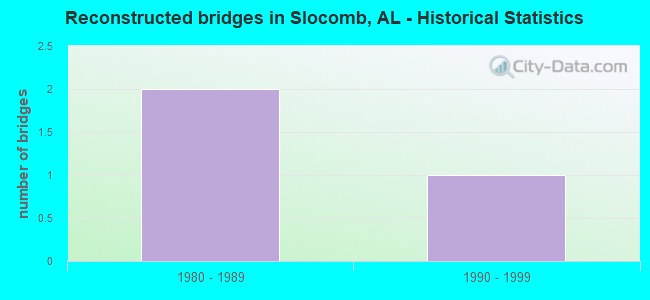
- Reconstructed bridges - Historical Statistics
- 21980-1989
- 11990-1999
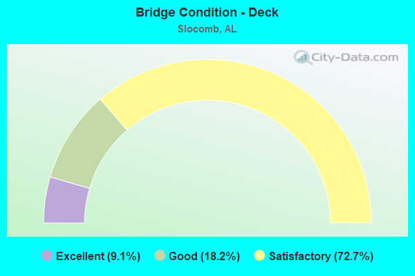
- Bridge Condition - Deck
- 9.1%Excellent
- 18.2%Good
- 72.7%Satisfactory
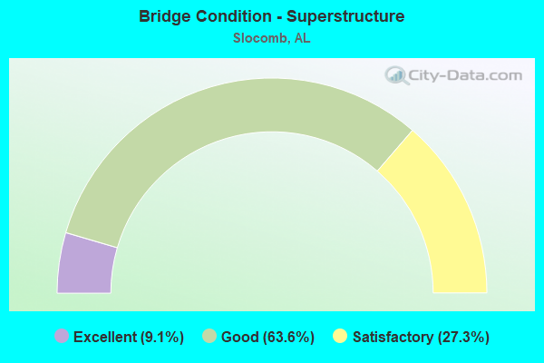
- Bridge Condition - Superstructure
- 9.1%Excellent
- 63.6%Good
- 27.3%Satisfactory
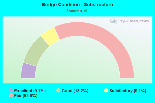
- Bridge Condition - Substructure
- 9.1%Excellent
- 18.2%Good
- 9.1%Satisfactory
- 63.6%Fair
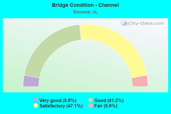
- Bridge Condition - Channel
- 5.9%Very good
- 41.2%Good
- 47.1%Satisfactory
- 5.9%Fair
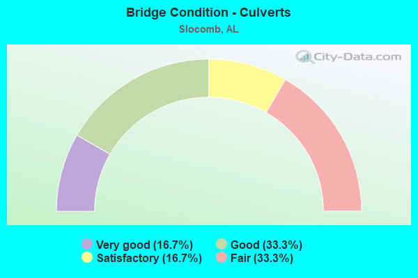
- Bridge Condition - Culverts
- 16.7%Very good
- 33.3%Good
- 16.7%Satisfactory
- 33.3%Fair
Find on map >> Show street view
Structure Number: 2994, Location: 3 MI. SE OF SLOCOMB (Lat: 31.076731, Lng: -85.555811), Route carried "on" structure: County highway , Year Built: 1947, Status: Posted for load, Structure Length: 0.91m (2.99ft), Average Daily Traffic: 127 (year 2020), Truck Traffic: 1%, Average Future Daily Traffic: 178 (year 2040), Design Load: H 15, Features Intersected: TINDILL BRANCH, Facility Carried by Structure: TINDILL CREEK ROAD
Minimum Vertical Clearance: 30+ m (98+ ft), Kilometerpoint: 0.010, Lanes on structure: 1, Owner: County Highway Agency, Approaching Roadway Width: 6.1m (20.0ft), Material/Design: Wood or Timber, Design/Construction: Stringer/Multi-beam, Number Of Spans In Main Unit: 2, Length of Maximum Span: 4.6m (15.1ft), Curb-To-Curb Width: 4.5m (14.8ft), Out-to-Out Width: 4.9m (16.1ft)
Condition: Deck: Satisfactory, Superstructure: Satisfactory, Substructure: Satisfactory, Channel: Good, Operating Rating: 26.9 metric tons, Method Used To Determine Operating Rating: Allowable Stress (AS), Inventory Rating: 19.9 metric tons, Method Used To Determine Inventory Rating: Allowable Stress (AS), Structural Evaluation: Somewhat better than minimum adequacy, Deck Geometry: High priority of replacement, Waterway Adequacy: Equal to present minimum criteria, Approach Roadway Alignment: Equal to present minimum criteria, Bridge Posting: Required (Relationship of Operating Rating to Maximum Legal Load: 30.0 - 39.9% below), Length Of Structure Improvement: 1.59m (5.22ft), Designated Inspection Frequency: Every 24 months, Other Special Inspection Frequency: Every 12 months, Inspection Date: November 2020, Other Special Inspection Date: November 2021, Bridge Improvement Cost: $174,000, Roadway Improvement Cost: $17,000, Total Project Cost: $191,000 ( Estimate for 2022), Deck Structure Type: Wood or Timber, Wearing Surface/Protective System: Wearing Surface: Wood or Timber
Find on map >> Show street view
Structure Number: 3386, Location: 4 MILES S W OF SLOCOMB (Lat: 31.056369, Lng: -85.624267), Route carried "on" structure: County highway , Year Built: 1990, Status: Closed, Structure Length: 1.40m (4.59ft), Average Daily Traffic: 40 (year 2020), Average Future Daily Traffic: 76 (year 2040), Design Load: H 15, Features Intersected: HURRICANE CREEK, Facility Carried by Structure: WHITE OAK ROAD
Minimum Vertical Clearance: 30+ m (98+ ft), Kilometerpoint: 0.010, Lanes on structure: 1, Owner: County Highway Agency, Approaching Roadway Width: 6.1m (20.0ft), Material/Design: Wood or Timber, Design/Construction: Stringer/Multi-beam, Number Of Spans In Main Unit: 3, Length of Maximum Span: 4.9m (16.1ft), Curb-To-Curb Width: 4.5m (14.8ft), Out-to-Out Width: 4.9m (16.1ft)
Condition: Deck: Satisfactory, Superstructure: Good, Substructure: Fair, Channel: Good, Deck Geometry: Equal to present minimum criteria, Waterway Adequacy: Equal to present minimum criteria, Approach Roadway Alignment: Meets minimum limits, Bridge Posting: Required (Relationship of Operating Rating to Maximum Legal Load: > 39.9% below), Length Of Structure Improvement: 2.07m (6.79ft), Designated Inspection Frequency: Every 24 months, Other Special Inspection Frequency: Every 12 months, Inspection Date: August 2020, Other Special Inspection Date: August 2020, Bridge Improvement Cost: $227,000, Roadway Improvement Cost: $23,000, Total Project Cost: $250,000 ( Estimate for 2022), Deck Structure Type: Wood or Timber, Wearing Surface/Protective System: Wearing Surface: Wood or Timber
Find on map >> Show street view
Structure Number: 4295, Location: 4 MILES SOUTH OF SLOCOMB (Lat: 31.056947, Lng: -85.616117), Route carried "on" structure: County highway 9, Year Built: 1952, Status: Open, Structure Length: 0.95m (3.12ft), Average Daily Traffic: 765 (year 2022), Truck Traffic: 10%, Average Future Daily Traffic: 1,075 (year 2042), Design Load: H 15, Features Intersected: WOLFPEN BRANCH
Minimum Vertical Clearance: 30+ m (98+ ft), Kilometerpoint: 0.010, Lanes on structure: 2, Owner: County Highway Agency, Approaching Roadway Width: 8.5m (27.9ft), Material/Design: Concrete, Design/Construction: Culvert, Number Of Spans In Main Unit: 3, Length of Maximum Span: 3.0m (9.8ft)
Condition: Channel: Satisfactory, Culverts: Fair, Operating Rating: 67.8 metric tons, Method Used To Determine Operating Rating: Load Factor (LF), Inventory Rating: 40.6 metric tons, Method Used To Determine Inventory Rating: Load Factor (LF), Structural Evaluation: Somewhat better than minimum adequacy, Waterway Adequacy: Equal to present minimum criteria, Approach Roadway Alignment: Equal to present desirable criteria, Length Of Structure Improvement: 1.63m (5.35ft), Designated Inspection Frequency: Every 24 months, Inspection Date: Febuary 2022, Bridge Improvement Cost: $291,000, Roadway Improvement Cost: $29,000, Total Project Cost: $320,000 ( Estimate for 2022)
Find on map >> Show street view
Structure Number: 5742, Location: 3 MI. SE OF SLOCOMB (Lat: 31.076406, Lng: -85.559042), Route carried "on" structure: County highway , Year Built: 1995, Status: Posted for load, Structure Length: 2.10m (6.89ft), Average Daily Traffic: 36 (year 2020), Average Future Daily Traffic: 59 (year 2040), Design Load: H 15, Features Intersected: DAVIS MILL CREEK, Facility Carried by Structure: TINDIL CREEK RD.
Minimum Vertical Clearance: 30+ m (98+ ft), Kilometerpoint: 0.010, Lanes on structure: 1, Owner: County Highway Agency, Approaching Roadway Width: 6.1m (20.0ft), Material/Design: Wood or Timber, Design/Construction: Stringer/Multi-beam, Number Of Spans In Main Unit: 4, Length of Maximum Span: 5.2m (17.1ft), Curb-To-Curb Width: 4.8m (15.7ft), Out-to-Out Width: 5.0m (16.4ft)
Condition: Deck: Satisfactory, Superstructure: Satisfactory, Substructure: Fair, Channel: Satisfactory, Operating Rating: 32.6 metric tons, Method Used To Determine Operating Rating: Allowable Stress (AS), Inventory Rating: 24.0 metric tons, Method Used To Determine Inventory Rating: Allowable Stress (AS), Structural Evaluation: Somewhat better than minimum adequacy, Deck Geometry: Equal to present desirable criteria, Waterway Adequacy: Meets minimum limits, Approach Roadway Alignment: Meets minimum limits, Bridge Posting: Required (Relationship of Operating Rating to Maximum Legal Load: 20.0 - 29.9% below), Length Of Structure Improvement: 2.88m (9.45ft), Designated Inspection Frequency: Every 24 months, Other Special Inspection Frequency: Every 12 months, Inspection Date: November 2020, Other Special Inspection Date: November 2021, Bridge Improvement Cost: $315,000, Roadway Improvement Cost: $32,000, Total Project Cost: $347,000 ( Estimate for 2022), Deck Structure Type: Wood or Timber, Wearing Surface/Protective System: Wearing Surface: Wood or Timber
Find on map >> Show street view
Structure Number: 7878, Location: 3 MILES E OF HARTFORD (Lat: 31.116589, Lng: -85.628114), Route carried "on" structure: County highway , Year Built: 1963, Status: Open, Structure Length: 1.92m (6.30ft), Average Daily Traffic: 60 (year 2021), Average Future Daily Traffic: 88 (year 2041), Design Load: H 20, Features Intersected: LITTLE CREEK, Facility Carried by Structure: LEWIS RD.
Minimum Vertical Clearance: 30+ m (98+ ft), Kilometerpoint: 0.010, Lanes on structure: 2, Owner: County Highway Agency, Approaching Roadway Width: 8.5m (27.9ft), Material/Design: Concrete, Design/Construction: Culvert, Number Of Spans In Main Unit: 5, Length of Maximum Span: 3.7m (12.1ft)
Condition: Channel: Satisfactory, Culverts: Satisfactory, Operating Rating: 43.6 metric tons, Method Used To Determine Operating Rating: Load Factor (LF), Inventory Rating: 26.1 metric tons, Method Used To Determine Inventory Rating: Load Factor (LF), Structural Evaluation: Equal to present minimum criteria, Waterway Adequacy: Equal to present minimum criteria, Approach Roadway Alignment: Equal to present minimum criteria, Length Of Structure Improvement: 2.65m (8.69ft), Designated Inspection Frequency: Every 24 months, Inspection Date: Febuary 2021, Bridge Improvement Cost: $521,000, Roadway Improvement Cost: $52,000, Total Project Cost: $573,000 ( Estimate for 2022)
Find on map >> Show street view
Structure Number: 9018, Location: 4 MI N OF SLOCOMB (Lat: 31.167722, Lng: -85.603931), Route carried "on" structure: County highway , Year Built: 1966, Year Reconstructed: 1991, Status: Posted for load, Structure Length: 1.34m (4.40ft), Average Daily Traffic: 25 (year 2020), Average Future Daily Traffic: 30 (year 2040), Features Intersected: PATES CREEK BRANCH, Facility Carried by Structure: STEWART RD.
Minimum Vertical Clearance: 30+ m (98+ ft), Kilometerpoint: 0.010, Lanes on structure: 1, Owner: County Highway Agency, Approaching Roadway Width: 6.1m (20.0ft), Material/Design: Wood or Timber, Design/Construction: Stringer/Multi-beam, Number Of Spans In Main Unit: 3, Length of Maximum Span: 4.6m (15.1ft), Curb-To-Curb Width: 4.6m (15.1ft), Out-to-Out Width: 5.0m (16.4ft)
Condition: Deck: Satisfactory, Superstructure: Good, Substructure: Good, Channel: Satisfactory, Operating Rating: 26.9 metric tons, Method Used To Determine Operating Rating: Allowable Stress (AS), Inventory Rating: 19.9 metric tons, Method Used To Determine Inventory Rating: Allowable Stress (AS), Structural Evaluation: Somewhat better than minimum adequacy, Deck Geometry: Better than present minimum criteria, Waterway Adequacy: Equal to present minimum criteria, Approach Roadway Alignment: Equal to present minimum criteria, Bridge Posting: Required (Relationship of Operating Rating to Maximum Legal Load: 30.0 - 39.9% below), Length Of Structure Improvement: 2.02m (6.63ft), Designated Inspection Frequency: Every 24 months, Other Special Inspection Frequency: Every 12 months, Inspection Date: August 2020, Other Special Inspection Date: August 2021, Bridge Improvement Cost: $221,000, Roadway Improvement Cost: $22,000, Total Project Cost: $243,000 ( Estimate for 2022), Deck Structure Type: Wood or Timber, Wearing Surface/Protective System: Wearing Surface: Bituminous
Find on map >> Show street view
Structure Number: 10352, Location: 2 MI S OF SLOCOMB (Lat: 31.082136, Lng: -85.610506), Route carried "on" structure: County highway 16, Year Built: 1970, Status: Open, Structure Length: 0.95m (3.12ft), Average Daily Traffic: 450 (year 2020), Truck Traffic: 5%, Average Future Daily Traffic: 665 (year 2040), Design Load: HS 20, Features Intersected: PINE LOG BRANCH
Minimum Vertical Clearance: 30+ m (98+ ft), Kilometerpoint: 0.010, Lanes on structure: 2, Owner: County Highway Agency, Approaching Roadway Width: 8.5m (27.9ft), Material/Design: Concrete, Design/Construction: Culvert, Number Of Spans In Main Unit: 3, Length of Maximum Span: 3.0m (9.8ft)
Condition: Channel: Satisfactory, Culverts: Good, Operating Rating: 50.4 metric tons, Method Used To Determine Operating Rating: Load Factor (LF), Inventory Rating: 30.3 metric tons, Method Used To Determine Inventory Rating: Load Factor (LF), Structural Evaluation: Better than present minimum criteria, Waterway Adequacy: Equal to present minimum criteria, Approach Roadway Alignment: Equal to present desirable criteria, Length Of Structure Improvement: 1.63m (5.35ft), Designated Inspection Frequency: Every 24 months, Inspection Date: November 2020, Bridge Improvement Cost: $376,000, Roadway Improvement Cost: $38,000, Total Project Cost: $414,000 ( Estimate for 2022)
Find on map >> Show street view
Structure Number: 12667, Location: 4 MI SW OF SLOCOMB (Lat: 31.062169, Lng: -85.632878), Route carried "on" structure: County highway , Year Built: 1982, Status: Open, Structure Length: 3.11m (10.20ft), Average Daily Traffic: 40 (year 2020), Average Future Daily Traffic: 76 (year 2040), Design Load: H 15, Features Intersected: HURRICANE CREEK, Facility Carried by Structure: MITCHELL RD.
Minimum Vertical Clearance: 30+ m (98+ ft), Kilometerpoint: 0.010, Lanes on structure: 2, Owner: County Highway Agency, Approaching Roadway Width: 7.3m (24.0ft), Material/Design: Concrete, Design/Construction: Channel Beam, Number Of Spans In Main Unit: 3, Length of Maximum Span: 10.4m (34.1ft), Curb-To-Curb Width: 7.3m (24.0ft), Out-to-Out Width: 8.1m (26.6ft)
Condition: Deck: Good, Superstructure: Good, Substructure: Fair, Channel: Satisfactory, Operating Rating: 45.1 metric tons, Method Used To Determine Operating Rating: Load Factor (LF), Inventory Rating: 27.0 metric tons, Method Used To Determine Inventory Rating: Load Factor (LF), Structural Evaluation: Somewhat better than minimum adequacy, Deck Geometry: Equal to present minimum criteria, Waterway Adequacy: Superior to present desirable criteria, Approach Roadway Alignment: Better than present minimum criteria, Length Of Structure Improvement: 3.96m (12.99ft), Designated Inspection Frequency: Every 24 months, Inspection Date: November 2020, Bridge Improvement Cost: $706,000, Roadway Improvement Cost: $71,000, Total Project Cost: $777,000 ( Estimate for 2022), Deck Structure Type: Concrete Precast Panels
Find on map >> Show street view
Structure Number: 15225, Location: 5 MI. N. FLA. LINE (Lat: 31.061250, Lng: -85.556067), Route carried "on" structure: State highway 103, Year Built: 1990, Status: Open, Structure Length: 5.00m (16.40ft), Average Daily Traffic: 1,510 (year 2013), Truck Traffic: 4%, Average Future Daily Traffic: 1,909 (year 2033), Design Load: HS 20, Features Intersected: WRIGHT'S CREEK
Minimum Vertical Clearance: 30+ m (98+ ft), Kilometerpoint: 7.986, Lanes on structure: 2, Owner: State Highway Agency, Approaching Roadway Width: 12.2m (40.0ft), Material/Design: Prestressed concrete continuous, Design/Construction: Stringer/Multi-beam, Number Of Spans In Main Unit: 4, Length of Maximum Span: 12.5m (41.0ft), Curb or Sidewalk Widths: Left: 0.2m (0.7ft), Right: 0.2m (0.7ft), Curb-To-Curb Width: 12.2m (40.0ft), Out-to-Out Width: 13.1m (43.0ft)
Condition: Deck: Good, Superstructure: Good, Substructure: Good, Channel: Good, Operating Rating: 54.1 metric tons, Method Used To Determine Operating Rating: Load Factor (LF), Inventory Rating: 30.8 metric tons, Method Used To Determine Inventory Rating: Load Factor (LF), Structural Evaluation: Better than present minimum criteria, Deck Geometry: Better than present minimum criteria, Waterway Adequacy: Equal to present desirable criteria, Approach Roadway Alignment: Equal to present desirable criteria, Length Of Structure Improvement: 6.02m (19.75ft), Designated Inspection Frequency: Every 24 months, Inspection Date: August 2021, Bridge Improvement Cost: $1,774,000, Roadway Improvement Cost: $177,000, Total Project Cost: $1,951,000 ( Estimate for 2022), Deck Structure Type: Concrete Cast-file-Place
Find on map >> Show street view
Structure Number: 15281, Location: 3 MI SW OF SLOCOMB (Lat: 31.071686, Lng: -85.619633), Route carried "on" structure: County highway , Year Built: 1946, Year Reconstructed: 1991, Status: Posted for load, Structure Length: 0.94m (3.08ft), Average Daily Traffic: 47 (year 2020), Average Future Daily Traffic: 61 (year 2040), Design Load: H 15, Features Intersected: PINE LOG BR., Facility Carried by Structure: UNION HILL RD.
Minimum Vertical Clearance: 30+ m (98+ ft), Kilometerpoint: 0.010, Lanes on structure: 1, Owner: County Highway Agency, Approaching Roadway Width: 6.1m (20.0ft), Material/Design: Wood or Timber, Design/Construction: Stringer/Multi-beam, Number Of Spans In Main Unit: 2, Length of Maximum Span: 4.6m (15.1ft), Curb-To-Curb Width: 4.5m (14.8ft), Out-to-Out Width: 4.9m (16.1ft)
Condition: Deck: Satisfactory, Superstructure: Good, Substructure: Fair, Channel: Satisfactory, Operating Rating: 27.4 metric tons, Method Used To Determine Operating Rating: Allowable Stress (AS), Inventory Rating: 20.3 metric tons, Method Used To Determine Inventory Rating: Allowable Stress (AS), Structural Evaluation: Somewhat better than minimum adequacy, Deck Geometry: Equal to present minimum criteria, Waterway Adequacy: Equal to present minimum criteria, Approach Roadway Alignment: Better than present minimum criteria, Bridge Posting: Required (Relationship of Operating Rating to Maximum Legal Load: 30.0 - 39.9% below), Length Of Structure Improvement: 1.61m (5.28ft), Designated Inspection Frequency: Every 24 months, Other Special Inspection Frequency: Every 12 months, Inspection Date: July 2020, Other Special Inspection Date: July 2021, Bridge Improvement Cost: $176,000, Roadway Improvement Cost: $18,000, Total Project Cost: $194,000 ( Estimate for 2018), Deck Structure Type: Wood or Timber, Wearing Surface/Protective System: Wearing Surface: Wood or Timber
Find on map >> Show street view
Structure Number: 16261, Location: 6 MI NE OF HARTFORD (Lat: 31.165222, Lng: -85.652744), Route carried "on" structure: County highway 85, Year Built: 1994, Status: Open, Structure Length: 0.62m (2.03ft), Average Daily Traffic: 120 (year 2021), Truck Traffic: 5%, Average Future Daily Traffic: 275 (year 2041), Design Load: H 15, Features Intersected: SANDY BRANCH
Minimum Vertical Clearance: 30+ m (98+ ft), Kilometerpoint: 10.499, Lanes on structure: 2, Owner: County Highway Agency, Approaching Roadway Width: 6.1m (20.0ft), Material/Design: Concrete, Design/Construction: Culvert, Number Of Spans In Main Unit: 2, Length of Maximum Span: 3.0m (9.8ft)
Condition: Channel: Good, Culverts: Good, Operating Rating: 88.9 metric tons, Method Used To Determine Operating Rating: Load Factor (LF), Inventory Rating: 88.9 metric tons, Method Used To Determine Inventory Rating: Load Factor (LF), Structural Evaluation: Better than present minimum criteria, Waterway Adequacy: Better than present minimum criteria, Approach Roadway Alignment: Better than present minimum criteria, Length Of Structure Improvement: 1.24m (4.07ft), Designated Inspection Frequency: Every 24 months, Inspection Date: January 2021, Bridge Improvement Cost: $344,000, Roadway Improvement Cost: $34,000, Total Project Cost: $378,000 ( Estimate for 2022)
Find on map >> Show street view
Structure Number: 16407, Location: 1.5MI N GENEVA CORD46 (Lat: 31.173567, Lng: -85.631150), Route carried "on" structure: State highway 123, Year Built: 2001, Status: Open, Structure Length: 2.00m (6.56ft), Average Daily Traffic: 2,400 (year 2013), Truck Traffic: 4%, Average Future Daily Traffic: 3,429 (year 2033), Design Load: HS 20, Features Intersected: PATES CREEK
Minimum Vertical Clearance: 30+ m (98+ ft), Kilometerpoint: 12.691, Lanes on structure: 2, Owner: State Highway Agency, Approaching Roadway Width: 9.9m (32.5ft), Material/Design: Concrete, Design/Construction: Culvert, Number Of Spans In Main Unit: 4, Length of Maximum Span: 4.9m (16.1ft)
Condition: Channel: Very good, Culverts: Very good, Operating Rating: 77.8 metric tons, Method Used To Determine Operating Rating: Load Factor (LF), Inventory Rating: 46.7 metric tons, Method Used To Determine Inventory Rating: Load Factor (LF), Structural Evaluation: Equal to present desirable criteria, Waterway Adequacy: Equal to present desirable criteria, Approach Roadway Alignment: Equal to present desirable criteria, Length Of Structure Improvement: 2.75m (9.02ft), Designated Inspection Frequency: Every 24 months, Inspection Date: April 2021, Bridge Improvement Cost: $954,000, Roadway Improvement Cost: $95,000, Total Project Cost: $1,049,000 ( Estimate for 2022)
Find on map >> Show street view
Structure Number: 17358, Location: 1 MILE SOUTH OF SLOCOMB (Lat: 31.077922, Lng: -85.612906), Route carried "on" structure: County highway 85, Year Built: 1991, Year Reconstructed: 1997, Status: Posted for load, Structure Length: 1.49m (4.89ft), Average Daily Traffic: 40 (year 2020), Average Future Daily Traffic: 50 (year 2040), Design Load: HS 20, Features Intersected: PINE LOG BR.
Minimum Vertical Clearance: 30+ m (98+ ft), Kilometerpoint: 0.000, Lanes on structure: 1, Owner: County Highway Agency, Approaching Roadway Width: 6.1m (20.0ft), Material/Design: Wood or Timber, Design/Construction: Stringer/Multi-beam, Number Of Spans In Main Unit: 3, Length of Maximum Span: 5.5m (18.0ft), Curb-To-Curb Width: 4.6m (15.1ft), Out-to-Out Width: 5.0m (16.4ft)
Condition: Deck: Satisfactory, Superstructure: Satisfactory, Substructure: Fair, Channel: Fair, Operating Rating: 31.8 metric tons, Method Used To Determine Operating Rating: Allowable Stress (AS), Inventory Rating: 23.5 metric tons, Method Used To Determine Inventory Rating: Allowable Stress (AS), Structural Evaluation: Somewhat better than minimum adequacy, Deck Geometry: Better than present minimum criteria, Waterway Adequacy: Meets minimum limits, Approach Roadway Alignment: Somewhat better than minimum adequacy, Bridge Posting: Required (Relationship of Operating Rating to Maximum Legal Load: 20.0 - 29.9% below), Length Of Structure Improvement: 2.17m (7.12ft), Designated Inspection Frequency: Every 24 months, Other Special Inspection Frequency: Every 12 months, Inspection Date: July 2020, Other Special Inspection Date: July 2021, Bridge Improvement Cost: $238,000, Roadway Improvement Cost: $24,000, Total Project Cost: $262,000 ( Estimate for 2022), Deck Structure Type: Wood or Timber, Wearing Surface/Protective System: Wearing Surface: Wood or Timber
Find on map >> Show street view
Structure Number: 1736, Location: 4 MILES S. OF SLOCOMB (Lat: 31.038117, Lng: -85.579228), Route carried "on" structure: County highway , Year Built: 1995, Status: Posted for load, Structure Length: 1.07m (3.51ft), Average Daily Traffic: 50 (year 2020), Average Future Daily Traffic: 60 (year 2040), Design Load: HS 20, Features Intersected: GRANT BRANCH, Facility Carried by Structure: POST OAK RD.
Minimum Vertical Clearance: 30+ m (98+ ft), Kilometerpoint: 0.000, Lanes on structure: 1, Owner: County Highway Agency, Approaching Roadway Width: 6.1m (20.0ft), Material/Design: Wood or Timber, Design/Construction: Stringer/Multi-beam, Number Of Spans In Main Unit: 2, Length of Maximum Span: 5.2m (17.1ft), Curb-To-Curb Width: 4.6m (15.1ft), Out-to-Out Width: 5.0m (16.4ft)
Condition: Deck: Satisfactory, Superstructure: Good, Substructure: Fair, Channel: Good, Operating Rating: 33.0 metric tons, Method Used To Determine Operating Rating: Allowable Stress (AS), Inventory Rating: 24.4 metric tons, Method Used To Determine Inventory Rating: Allowable Stress (AS), Structural Evaluation: Somewhat better than minimum adequacy, Deck Geometry: Better than present minimum criteria, Waterway Adequacy: Meets minimum limits, Approach Roadway Alignment: Equal to present desirable criteria, Bridge Posting: Required (Relationship of Operating Rating to Maximum Legal Load: 20.0 - 29.9% below), Length Of Structure Improvement: 1.74m (5.71ft), Designated Inspection Frequency: Every 24 months, Other Special Inspection Frequency: Every 12 months, Inspection Date: June 2021, Other Special Inspection Date: June 2021, Bridge Improvement Cost: $191,000, Roadway Improvement Cost: $19,000, Total Project Cost: $210,000 ( Estimate for 2022), Deck Structure Type: Wood or Timber, Wearing Surface/Protective System: Wearing Surface: Wood or Timber
Find on map >> Show street view
Structure Number: 17361, Location: 4 MILES S. OF SLOCOMB (Lat: 31.038158, Lng: -85.578411), Route carried "on" structure: County highway , Year Built: 1995, Status: Posted for load, Structure Length: 1.58m (5.18ft), Average Daily Traffic: 50 (year 2020), Average Future Daily Traffic: 60 (year 2040), Design Load: HS 20, Features Intersected: GRANT BRANCH, Facility Carried by Structure: POST OAK RD
Minimum Vertical Clearance: 30+ m (98+ ft), Kilometerpoint: 0.000, Lanes on structure: 1, Owner: County Highway Agency, Approaching Roadway Width: 6.1m (20.0ft), Material/Design: Wood or Timber, Design/Construction: Stringer/Multi-beam, Number Of Spans In Main Unit: 3, Length of Maximum Span: 5.2m (17.1ft), Curb-To-Curb Width: 4.6m (15.1ft), Out-to-Out Width: 5.0m (16.4ft)
Condition: Deck: Satisfactory, Superstructure: Good, Substructure: Fair, Channel: Good, Operating Rating: 32.8 metric tons, Method Used To Determine Operating Rating: Allowable Stress (AS), Inventory Rating: 24.2 metric tons, Method Used To Determine Inventory Rating: Allowable Stress (AS), Structural Evaluation: Somewhat better than minimum adequacy, Deck Geometry: Better than present minimum criteria, Waterway Adequacy: Equal to present minimum criteria, Approach Roadway Alignment: Equal to present minimum criteria, Bridge Posting: Required (Relationship of Operating Rating to Maximum Legal Load: 20.0 - 29.9% below), Length Of Structure Improvement: 2.26m (7.41ft), Designated Inspection Frequency: Every 24 months, Other Special Inspection Frequency: Every 12 months, Inspection Date: September 2020, Other Special Inspection Date: September 2021, Bridge Improvement Cost: $248,000, Roadway Improvement Cost: $25,000, Total Project Cost: $273,000 ( Estimate for 2022), Deck Structure Type: Wood or Timber, Wearing Surface/Protective System: Wearing Surface: Wood or Timber
Find on map >> Show street view
Structure Number: 17838, Location: 2 MILES S.W. OF MALVERN (Lat: 31.090803, Lng: -85.548686), Route carried "on" structure: County highway 28, Year Built: 1951, Status: Open, Structure Length: 0.92m (3.02ft), Average Daily Traffic: 550 (year 2019), Average Future Daily Traffic: 740 (year 2039), Design Load: HS 20, Features Intersected: TINDIL BRANCH
Minimum Vertical Clearance: 30+ m (98+ ft), Kilometerpoint: 0.000, Lanes on structure: 2, Owner: County Highway Agency, Approaching Roadway Width: 7.3m (24.0ft), Material/Design: Concrete, Design/Construction: Culvert, Number Of Spans In Main Unit: 4, Length of Maximum Span: 1.5m (4.9ft)
Condition: Channel: Good, Culverts: Fair, Operating Rating: 43.5 metric tons, Method Used To Determine Operating Rating: Field evaluation and documented engineering judgment, Inventory Rating: 32.7 metric tons, Method Used To Determine Inventory Rating: Field evaluation and documented engineering judgment, Structural Evaluation: Somewhat better than minimum adequacy, Waterway Adequacy: Equal to present desirable criteria, Approach Roadway Alignment: Equal to present desirable criteria, Length Of Structure Improvement: 1.59m (5.22ft), Designated Inspection Frequency: Every 24 months, Inspection Date: Febuary 2021, Bridge Improvement Cost: $404,000, Roadway Improvement Cost: $40,000, Total Project Cost: $444,000 ( Estimate for 2022)
Find on map >> Show street view
Structure Number: 20306, Location: 2 MILES NW OF SLOCOMB (Lat: 31.132817, Lng: -85.615617), Route carried "on" structure: County highway , Year Built: 2013, Status: Open, Structure Length: 3.11m (10.20ft), Average Daily Traffic: 62 (year 2021), Average Future Daily Traffic: 87 (year 2041), Design Load: HS 20, Features Intersected: LITTLE CREEK, Facility Carried by Structure: HARRELL ROAD
Minimum Vertical Clearance: 30+ m (98+ ft), Kilometerpoint: 0.010, Lanes on structure: 2, Owner: County Highway Agency, Approaching Roadway Width: 6.7m (22.0ft), Material/Design: Concrete, Design/Construction: Channel Beam, Number Of Spans In Main Unit: 3, Length of Maximum Span: 10.4m (34.1ft), Curb-To-Curb Width: 7.5m (24.6ft), Out-to-Out Width: 8.2m (26.9ft)
Condition: Deck: Excellent, Superstructure: Excellent, Substructure: Excellent, Channel: Satisfactory, Operating Rating: 75.2 metric tons, Method Used To Determine Operating Rating: Load Factor (LF), Inventory Rating: 45.2 metric tons, Method Used To Determine Inventory Rating: Load Factor (LF), Structural Evaluation: Superior to present desirable criteria, Deck Geometry: Equal to present minimum criteria, Waterway Adequacy: Equal to present desirable criteria, Approach Roadway Alignment: Equal to present minimum criteria, Length Of Structure Improvement: 3.96m (12.99ft), Designated Inspection Frequency: Every 24 months, Inspection Date: March 2021, Bridge Improvement Cost: $733,000, Roadway Improvement Cost: $73,000, Total Project Cost: $806,000 ( Estimate for 2022), Deck Structure Type: Concrete Precast Panels