Bridge Statistics for Smithers, West Virginia (WV)
Condition, Traffic, Stress, Structural Evaluation, Project Costs
- National Bridge Inventory (NBI) Statistics
- 12Number of bridges
- 62ft / 19.2mTotal length
- $4,470,000Total costs
- 26,317Total average daily traffic
- 1,971Total average daily truck traffic
- National Bridge Inventory (NBI) Registered Bridges for Smithers
- No street view available for this location
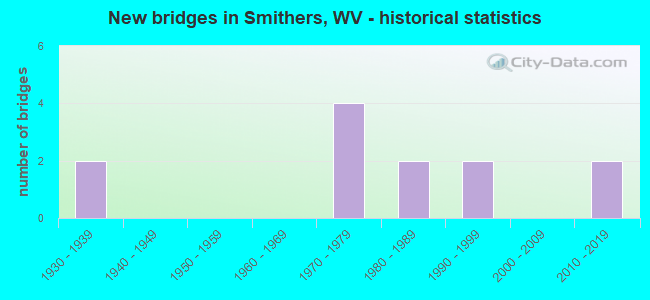
- New bridges - historical statistics
- 21930-1939
- 41970-1979
- 21980-1989
- 21990-1999
- 22010-2019


- Bridge Condition - Deck
- 50.0%Good
- 20.0%Fair
- 30.0%Poor

- Bridge Condition - Superstructure
- 30.0%Good
- 20.0%Satisfactory
- 20.0%Fair
- 30.0%Poor

- Bridge Condition - Substructure
- 10.0%Good
- 30.0%Satisfactory
- 50.0%Fair
- 10.0%Poor

- Bridge Condition - Channel
- 10.0%Very good
- 20.0%Good
- 40.0%Satisfactory
- 30.0%Fair
Find on map >> Show street view
Structure Number: 10A003, Location: 0.09 Miles N. of CR 2/2 (Lat: 38.187631, Lng: -81.297889), Route carried "on" structure: County highway 200, Year Built: 1977, Status: Open, Structure Length: 3.59m (11.78ft), Average Daily Traffic: 4,323 (year 2019), Truck Traffic: 6%, Average Future Daily Traffic: 5,274 (year 2039), Design Load: HS 20, Features Intersected: SMITHERS CREEK, Facility Carried by Structure: COUNTY ROUTE 2
Minimum Vertical Clearance: 30+ m (98+ ft), Kilometerpoint: 1.127, Lanes on structure: 2, Owner: State Highway Agency, Approaching Roadway Width: 8.8m (28.9ft), Skew: 4 degrees, Material/Design: Steel continuous, Design/Construction: Stringer/Multi-beam, Number Of Spans In Main Unit: 2, Length of Maximum Span: 17.1m (56.1ft), Curb-To-Curb Width: 8.7m (28.5ft), Out-to-Out Width: 9.9m (32.5ft)
Condition: Deck: Fair, Superstructure: Good, Substructure: Fair, Channel: Fair, Operating Rating: 68.0 metric tons, Method Used To Determine Operating Rating: Load Factor (LF), Inventory Rating: 41.7 metric tons, Method Used To Determine Inventory Rating: Load Factor (LF), Structural Evaluation: Somewhat better than minimum adequacy, Deck Geometry: Meets minimum limits, Waterway Adequacy: Equal to present desirable criteria, Approach Roadway Alignment: Better than present minimum criteria, Length Of Structure Improvement: 3.60m (11.81ft), Designated Inspection Frequency: Every 24 months, Inspection Date: April 2021, Bridge Improvement Cost: $118,000, Total Project Cost: $118,000 ( Estimate for 2021), Deck Structure Type: Concrete Cast-file-Place, Wearing Surface/Protective System: Wearing Surface: Monolithic Concrete, Deck Protection: Epoxy Coated Reinforcing
Find on map >> Show street view
Structure Number: 10A004, Location: 0.02 Miles N. of CR 2/15 (Lat: 38.194111, Lng: -81.296111), Route carried "on" structure: County highway 200, Year Built: 1976, Status: Posted for load, Structure Length: 1.54m (5.05ft), Average Daily Traffic: 1,723 (year 2020), Truck Traffic: 6%, Average Future Daily Traffic: 2,102 (year 2040), Design Load: HS 20, Features Intersected: SMITHERS CREEK, Facility Carried by Structure: COUNTY ROUTE 2
Minimum Vertical Clearance: 30+ m (98+ ft), Kilometerpoint: 1.883, Lanes on structure: 2, Owner: State Highway Agency, Approaching Roadway Width: 8.5m (27.9ft), Skew: 2 degrees, Material/Design: Prestressed concrete, Design/Construction: Channel Beam, Number Of Spans In Main Unit: 1, Length of Maximum Span: 14.9m (48.9ft), Curb or Sidewalk Widths: Left: 0.2m (0.7ft), Right: 0.2m (0.7ft), Curb-To-Curb Width: 7.7m (25.3ft), Out-to-Out Width: 8.2m (26.9ft)
Condition: Deck: Poor, Superstructure: Poor, Substructure: Fair, Channel: Satisfactory, Operating Rating: 49.0 metric tons, Method Used To Determine Operating Rating: Load Factor (LF), Inventory Rating: 26.3 metric tons, Method Used To Determine Inventory Rating: Load Factor (LF), Structural Evaluation: Meets minimum limits, Deck Geometry: Meets minimum limits, Waterway Adequacy: Equal to present desirable criteria, Approach Roadway Alignment: Equal to present desirable criteria, Length Of Structure Improvement: 1.55m (5.09ft), Designated Inspection Frequency: Every 24 months, Other Special Inspection Frequency: Every 6 months, Inspection Date: April 2021, Other Special Inspection Date: October 2021, Bridge Improvement Cost: $213,000, Roadway Improvement Cost: $111,000, Total Project Cost: $324,000 ( Estimate for 2021), Deck Structure Type: Other, Wearing Surface/Protective System: Wearing Surface: Bituminous
Find on map >> Show street view
Structure Number: 10A005, Location: 0.03 Miles N. of CR 2/3 (Lat: 38.199011, Lng: -81.295389), Route carried "on" structure: County highway 200, Year Built: 1976, Status: Posted for load, Structure Length: 0.96m (3.15ft), Average Daily Traffic: 4,323 (year 2019), Truck Traffic: 6%, Average Future Daily Traffic: 5,274 (year 2039), Design Load: HS 20, Features Intersected: BULL PUSH CREEK, Facility Carried by Structure: COUNTY ROUTE 2
Minimum Vertical Clearance: 30+ m (98+ ft), Kilometerpoint: 2.462, Lanes on structure: 2, Owner: State Highway Agency, Approaching Roadway Width: 7.3m (24.0ft), Material/Design: Prestressed concrete, Design/Construction: Channel Beam, Number Of Spans In Main Unit: 1, Length of Maximum Span: 9.1m (29.9ft), Curb-To-Curb Width: 6.8m (22.3ft), Out-to-Out Width: 7.3m (24.0ft)
Condition: Deck: Poor, Superstructure: Poor, Substructure: Fair, Channel: Satisfactory, Operating Rating: 35.4 metric tons, Method Used To Determine Operating Rating: Load Factor (LF), Inventory Rating: 21.8 metric tons, Method Used To Determine Inventory Rating: Load Factor (LF), Structural Evaluation: Meets minimum limits, Deck Geometry: High priority of replacement, Waterway Adequacy: Superior to present desirable criteria, Approach Roadway Alignment: Equal to present minimum criteria, Length Of Structure Improvement: 1.65m (5.41ft), Designated Inspection Frequency: Every 24 months, Inspection Date: April 2021, Bridge Improvement Cost: $451,000, Roadway Improvement Cost: $289,000, Total Project Cost: $740,000 ( Estimate for 2021), Deck Structure Type: Other, Wearing Surface/Protective System: Wearing Surface: Bituminous
Find on map >> Show street view
Structure Number: 10A006, Location: 0.30 Miles N. of CR 2/14 (Lat: 38.200550, Lng: -81.290081), Route carried "on" structure: County highway 200, Year Built: 1989, Status: Open, Structure Length: 2.18m (7.15ft), Average Daily Traffic: 4,323 (year 2020), Truck Traffic: 6%, Average Future Daily Traffic: 5,274 (year 2040), Design Load: HS 20, Features Intersected: SMITHERS CREEK, Facility Carried by Structure: COUNTY ROUTE 2
Minimum Vertical Clearance: 30+ m (98+ ft), Kilometerpoint: 2.961, Lanes on structure: 2, Owner: State Highway Agency, Approaching Roadway Width: 6.7m (22.0ft), Skew: 3 degrees, Material/Design: Prestressed concrete, Design/Construction: Box Beam or Girders - Multiple, Number Of Spans In Main Unit: 1, Length of Maximum Span: 21.3m (69.9ft), Curb or Sidewalk Widths: Left: 0.2m (0.7ft), Right: 0.2m (0.7ft), Curb-To-Curb Width: 8.7m (28.5ft), Out-to-Out Width: 9.2m (30.2ft)
Condition: Deck: Good, Superstructure: Satisfactory, Substructure: Fair, Channel: Fair, Operating Rating: 88.9 metric tons, Method Used To Determine Operating Rating: Load Factor (LF), Inventory Rating: 64.4 metric tons, Method Used To Determine Inventory Rating: Load Factor (LF), Structural Evaluation: Somewhat better than minimum adequacy, Deck Geometry: Meets minimum limits, Waterway Adequacy: Equal to present desirable criteria, Approach Roadway Alignment: Better than present minimum criteria, Designated Inspection Frequency: Every 24 months, Inspection Date: June 2021, Deck Structure Type: Other, Wearing Surface/Protective System: Wearing Surface: Bituminous, Deck Protection: Epoxy Coated Reinforcing
Find on map >> Show street view
Structure Number: 10A007, Location: 0.07 Miles N. of CR 2/13 (Lat: 38.205169, Lng: -81.269850), Route carried "on" structure: County highway 200, Year Built: 1976, Status: Posted for load, Structure Length: 1.26m (4.13ft), Average Daily Traffic: 1,723 (year 2020), Truck Traffic: 6%, Average Future Daily Traffic: 2,102 (year 2040), Design Load: HS 20, Features Intersected: SMITHERS CREEK, Facility Carried by Structure: COUNTY ROUTE 2
Minimum Vertical Clearance: 30+ m (98+ ft), Kilometerpoint: 4.892, Lanes on structure: 2, Owner: State Highway Agency, Approaching Roadway Width: 6.7m (22.0ft), Skew: 4 degrees, Material/Design: Prestressed concrete, Design/Construction: Channel Beam, Number Of Spans In Main Unit: 1, Length of Maximum Span: 12.2m (40.0ft), Curb or Sidewalk Widths: Left: 0.2m (0.7ft), Right: 0.2m (0.7ft), Curb-To-Curb Width: 6.8m (22.3ft), Out-to-Out Width: 7.3m (24.0ft)
Condition: Deck: Poor, Superstructure: Poor, Substructure: Satisfactory, Channel: Fair, Operating Rating: 28.1 metric tons, Method Used To Determine Operating Rating: Field evaluation and documented engineering judgment, Inventory Rating: 11.8 metric tons, Method Used To Determine Inventory Rating: Field evaluation and documented engineering judgment, Structural Evaluation: High priority of replacement, Deck Geometry: High priority of corrective action, Waterway Adequacy: Equal to present desirable criteria, Approach Roadway Alignment: Equal to present desirable criteria, Length Of Structure Improvement: 1.89m (6.20ft), Designated Inspection Frequency: Every 24 months, Other Special Inspection Frequency: Every 6 months, Inspection Date: September 2020, Other Special Inspection Date: September 2021, Bridge Improvement Cost: $512,000, Roadway Improvement Cost: $330,000, Total Project Cost: $842,000 ( Estimate for 2021), Deck Structure Type: Other, Wearing Surface/Protective System: Wearing Surface: Bituminous
Find on map >> Show street view
Structure Number: 10A008, Location: 0.01 Miles E. of CR 2 (Lat: 38.186350, Lng: -81.298969), Route carried "on" structure: County highway 202, Year Built: 1993, Status: Open, Structure Length: 1.39m (4.56ft), Average Daily Traffic: 138 (year 2019), Truck Traffic: 6%, Average Future Daily Traffic: 168 (year 2039), Design Load: HS 25 or greater, Features Intersected: SMITHERS CREEK, Facility Carried by Structure: COUNTY ROUTE 2/2
Minimum Vertical Clearance: 30+ m (98+ ft), Kilometerpoint: 0.016, Lanes on structure: 1, Owner: State Highway Agency, Approaching Roadway Width: 4.6m (15.1ft), Skew: 4 degrees, Material/Design: Steel, Design/Construction: Stringer/Multi-beam, Number Of Spans In Main Unit: 1, Length of Maximum Span: 12.8m (42.0ft), Curb-To-Curb Width: 4.5m (14.8ft), Out-to-Out Width: 4.7m (15.4ft)
Condition: Deck: Good, Superstructure: Fair, Substructure: Fair, Channel: Satisfactory, Operating Rating: 88.9 metric tons, Method Used To Determine Operating Rating: Load Factor (LF), Inventory Rating: 66.2 metric tons, Method Used To Determine Inventory Rating: Load Factor (LF), Structural Evaluation: Somewhat better than minimum adequacy, Deck Geometry: High priority of replacement, Waterway Adequacy: Equal to present desirable criteria, Approach Roadway Alignment: Equal to present minimum criteria, Length Of Structure Improvement: 1.40m (4.59ft), Designated Inspection Frequency: Every 24 months, Other Special Inspection Frequency: Every 12 months, Inspection Date: March 2021, Other Special Inspection Date: March 2021, Bridge Improvement Cost: $6,000, Roadway Improvement Cost: $1,000, Total Project Cost: $7,000 ( Estimate for 2021), Deck Structure Type: Wood or Timber, Wearing Surface/Protective System: Deck Protection: Other
Find on map >> Show street view
Structure Number: 10A14, Location: 0.06 Miles E. of CR 2 (Lat: 38.181061, Lng: -81.306719), Route carried "on" structure: US 6000, Year Built: 1936, Status: Posted for load, Structure Length: 4.48m (14.70ft), Average Daily Traffic: 6,632 (year 2019), Truck Traffic: 12%, Average Future Daily Traffic: 8,091 (year 2039), Features Intersected: Smithers Ck. & CR 21/15, Facility Carried by Structure: US 60
Minimum Vertical Clearance: 30+ m (98+ ft), Kilometerpoint: 0.515, Lanes on structure: 3, Lanes under structure: 2, Base Highway Network: Yes, Owner: State Highway Agency, Approaching Roadway Width: 15.2m (49.9ft), Skew: 1 degrees, Material/Design: Concrete, Design/Construction: Tee Beam, Number Of Spans In Main Unit: 3, Length of Maximum Span: 14.4m (47.2ft), Curb or Sidewalk Widths: Left: 0.0m, Right: 1.4m (4.6ft), Curb-To-Curb Width: 11.8m (38.7ft), Out-to-Out Width: 14.6m (47.9ft)
Condition: Deck: Fair, Superstructure: Fair, Substructure: Poor, Channel: Good, Operating Rating: 55.3 metric tons, Method Used To Determine Operating Rating: Field evaluation and documented engineering judgment, Inventory Rating: 23.6 metric tons, Method Used To Determine Inventory Rating: Field evaluation and documented engineering judgment, Structural Evaluation: Meets minimum limits, Deck Geometry: High priority of corrective action, Underclear: High priority of replacement, Waterway Adequacy: Superior to present desirable criteria, Approach Roadway Alignment: Equal to present desirable criteria, Length Of Structure Improvement: 5.33m (17.49ft), Designated Inspection Frequency: Every 24 months, Inspection Date: May 2021, Bridge Improvement Cost: $1,267,000, Roadway Improvement Cost: $828,000, Total Project Cost: $2,095,000 ( Estimate for 2021), Deck Structure Type: Concrete Cast-file-Place, Wearing Surface/Protective System: Wearing Surface: Bituminous
Find on map >> Show street view
Structure Number: 10A208, Location: 0.01 Miles N. of CR 2 (Lat: 38.202411, Lng: -81.277281), Route carried "on" structure: County highway 212, Year Built: 1986, Status: Open, Structure Length: 1.29m (4.23ft), Average Daily Traffic: 10 (year 2020), Truck Traffic: 6%, Average Future Daily Traffic: 12 (year 2040), Design Load: HS 20, Features Intersected: SMITHERS CREEK, Facility Carried by Structure: COUNTY ROUTE 2/12
Minimum Vertical Clearance: 30+ m (98+ ft), Kilometerpoint: 0.016, Lanes on structure: 1, Owner: State Highway Agency, Approaching Roadway Width: 3.7m (12.1ft), Material/Design: Steel, Design/Construction: Stringer/Multi-beam, Number Of Spans In Main Unit: 1, Length of Maximum Span: 11.8m (38.7ft), Curb-To-Curb Width: 4.8m (15.7ft), Out-to-Out Width: 4.9m (16.1ft)
Condition: Deck: Good, Superstructure: Satisfactory, Substructure: Satisfactory, Channel: Very good, Operating Rating: 86.2 metric tons, Method Used To Determine Operating Rating: Load Factor (LF), Inventory Rating: 51.7 metric tons, Method Used To Determine Inventory Rating: Load Factor (LF), Structural Evaluation: Equal to present minimum criteria, Deck Geometry: Equal to present desirable criteria, Waterway Adequacy: Equal to present desirable criteria, Approach Roadway Alignment: Equal to present minimum criteria, Designated Inspection Frequency: Every 24 months, Inspection Date: November 2021, Deck Structure Type: Wood or Timber, Wearing Surface/Protective System: Deck Protection: Other
Find on map >> Show street view
Structure Number: 10A254, Location: 0.02 Miles S. of CR 2 (Lat: 38.181331, Lng: -81.306039), Route carried "on" structure: County highway 2115, Year Built: 1998, Status: Open, Structure Length: 1.31m (4.30ft), Average Daily Traffic: 996 (year 2019), Truck Traffic: 6%, Average Future Daily Traffic: 1,215 (year 2039), Design Load: HS 25 or greater, Features Intersected: SMITHERS CREEK, Facility Carried by Structure: COUNTY ROUTE 21/15
Minimum Vertical Clearance: 30+ m (98+ ft), Kilometerpoint: 1.207, Lanes on structure: 2, Owner: State Highway Agency, Approaching Roadway Width: 7.3m (24.0ft), Skew: 1 degrees, Material/Design: Prestressed concrete, Design/Construction: Box Beam or Girders - Multiple, Number Of Spans In Main Unit: 1, Length of Maximum Span: 12.0m (39.4ft), Curb-To-Curb Width: 7.1m (23.3ft), Out-to-Out Width: 7.3m (24.0ft)
Condition: Deck: Good, Superstructure: Good, Substructure: Satisfactory, Channel: Good, Operating Rating: 88.0 metric tons, Method Used To Determine Operating Rating: Load Factor (LF), Inventory Rating: 53.5 metric tons, Method Used To Determine Inventory Rating: Load Factor (LF), Structural Evaluation: Equal to present minimum criteria, Deck Geometry: Meets minimum limits, Waterway Adequacy: Better than present minimum criteria, Approach Roadway Alignment: Meets minimum limits, Length Of Structure Improvement: 1.31m (4.30ft), Designated Inspection Frequency: Every 24 months, Inspection Date: May 2021, Bridge Improvement Cost: $148,000, Roadway Improvement Cost: $145,000, Total Project Cost: $344,000 ( Estimate for 2021), Deck Structure Type: Other, Wearing Surface/Protective System: Wearing Surface: Epoxy Overlay, Membrane: Preformed Fabric, Deck Protection: Epoxy Coated Reinforcing
Find on map >> Show street view
Structure Number: 10A304, Location: 0.01 Miles W. of CR 21/15 (Lat: 38.180989, Lng: -81.307081), Route carried "on" structure: County highway 16017, Year Built: 2011, Status: Open, Structure Length: 1.22m (4.00ft), Average Daily Traffic: 30 (year 2019), Truck Traffic: 6%, Average Future Daily Traffic: 37 (year 2039), Features Intersected: SMITHERS CREEK, Facility Carried by Structure: CO. ROUTE 160/17
Minimum Vertical Clearance: 30+ m (98+ ft), Kilometerpoint: 0.129, Lanes on structure: 2, Owner: State Highway Agency, Approaching Roadway Width: 6.7m (22.0ft), Material/Design: Prestressed concrete, Design/Construction: Box Beam or Girders - Multiple, Number Of Spans In Main Unit: 1, Length of Maximum Span: 11.0m (36.1ft), Curb or Sidewalk Widths: Left: 0.0m, Right: 0.9m (3.0ft), Curb-To-Curb Width: 8.1m (26.6ft), Out-to-Out Width: 9.3m (30.5ft)
Condition: Deck: Good, Superstructure: Good, Substructure: Good, Channel: Satisfactory, Operating Rating: 41.7 metric tons, Method Used To Determine Operating Rating: Load and Resistance Factor (LRFR), Inventory Rating: 32.7 metric tons, Method Used To Determine Inventory Rating: Load and Resistance Factor (LRFR), Structural Evaluation: Better than present minimum criteria, Deck Geometry: Equal to present minimum criteria, Waterway Adequacy: Equal to present minimum criteria, Approach Roadway Alignment: Equal to present desirable criteria, Designated Inspection Frequency: Every 24 months, Inspection Date: November 2020, Deck Structure Type: Other, Wearing Surface/Protective System: Wearing Surface: Monolithic Concrete, Deck Protection: Epoxy Coated Reinforcing
Find on map >> Show street view
Structure Number: 10A101, Location: 0.08 Miles S. of CR 2 (Lat: 38.180989, Lng: -81.306889), Route carried "under" structure: County highway 2115, Year Built: 2012, Structure Length: 0. m, Average Daily Traffic: 996 (year 2019), Truck Traffic: 6%, Features Intersected: NORFOLK SOUTHERN RR, Facility Carried by Structure: NORFOLK SOUTHERN R
Minimum Vertical Clearance: 3.91m (12.83ft), Kilometerpoint: 1.127, Lanes under structure: 1, Material/Design: Steel, Design/Construction: Girder and Floorbeam System, Length of Maximum Span: 21.9m (71.9ft)
Find on map >> Show street view
Structure Number: 10A14, Location: 0.06 Miles E. of CR 2 (Lat: 38.181067, Lng: -81.306725), Route carried "under" structure: County highway 2115, Year Built: 1936, Structure Length: 0. m, Average Daily Traffic: 1,100 (year 0012), Truck Traffic: 6%, Features Intersected: Smithers Ck. & CR 21/15, Facility Carried by Structure: US 60
Minimum Vertical Clearance: 4.01m (13.16ft), Kilometerpoint: 0.113, Lanes on structure: 3, Lanes under structure: 2, Length of Maximum Span: 14.4m (47.2ft)