Bridge Statistics for Smithfield, Virginia (VA)
Condition, Traffic, Stress, Structural Evaluation, Project Costs
- National Bridge Inventory (NBI) Statistics
- 15Number of bridges
- 476ft / 145mTotal length
- $2,923,000Total costs
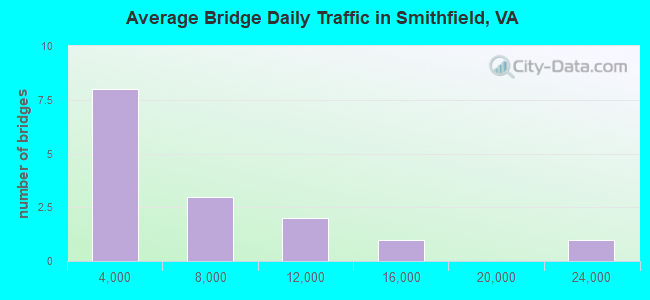
- 81,784Total average daily traffic
- 2,186Total average daily truck traffic
- National Bridge Inventory (NBI) Registered Bridges for Smithfield
- No street view available for this location
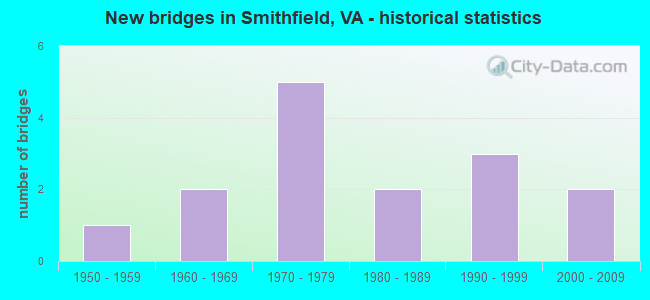
- New bridges - historical statistics
- 11950-1959
- 21960-1969
- 51970-1979
- 21980-1989
- 31990-1999
- 22000-2009
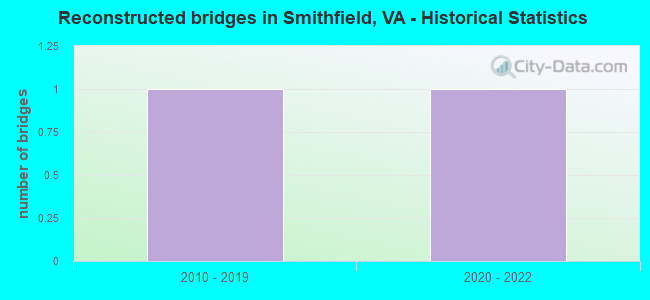
- Reconstructed bridges - Historical Statistics
- 12010-2019
- 12020-2022
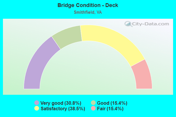
- Bridge Condition - Deck
- 30.8%Very good
- 15.4%Good
- 38.5%Satisfactory
- 15.4%Fair
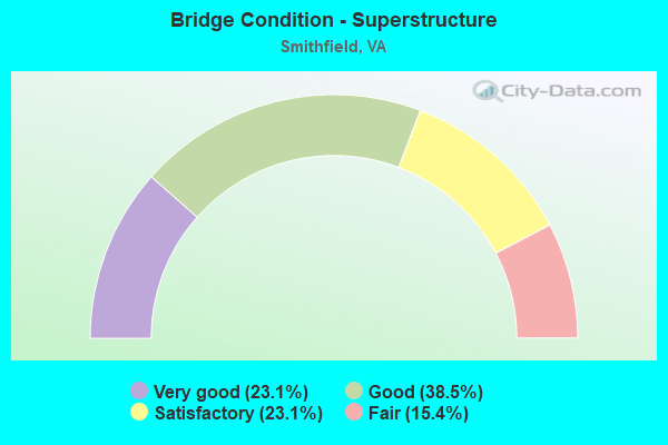
- Bridge Condition - Superstructure
- 23.1%Very good
- 38.5%Good
- 23.1%Satisfactory
- 15.4%Fair
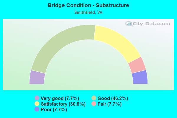
- Bridge Condition - Substructure
- 7.7%Very good
- 46.2%Good
- 30.8%Satisfactory
- 7.7%Fair
- 7.7%Poor

- Bridge Condition - Channel
- 33.3%Very good
- 44.4%Good
- 22.2%Satisfactory
Find on map >> Show street view
Structure Number: 4282, Location: 0.00-Rt.501 / 0.15-Rt.846 (Lat: 37.368658, Lng: -79.113328), Route carried "on" structure: County highway 665, Year Built: 1986, Status: Open, Structure Length: 6.16m (20.21ft), Average Daily Traffic: 1,353 (year 2020), Average Future Daily Traffic: 1,488 (year 2040), Design Load: HS 20+Mod, Features Intersected: NS Railway, Facility Carried by Structure: Eastbrook Road
Minimum Vertical Clearance: 30+ m (98+ ft), Kilometerpoint: 0.016, Lanes on structure: 2, Owner: State Highway Agency, Approaching Roadway Width: 8.7m (28.5ft), Skew: 1 degrees, Material/Design: Steel, Design/Construction: Stringer/Multi-beam, Number Of Spans In Main Unit: 3, Length of Maximum Span: 21.4m (70.2ft), Curb-To-Curb Width: 8.7m (28.5ft), Out-to-Out Width: 9.7m (31.8ft)
Condition: Deck: Good, Superstructure: Good, Substructure: Good, Operating Rating: 68.9 metric tons, Method Used To Determine Operating Rating: Load and Resistance Factor (LRFR), Inventory Rating: 52.6 metric tons, Method Used To Determine Inventory Rating: Load and Resistance Factor (LRFR), Structural Evaluation: Better than present minimum criteria, Deck Geometry: Somewhat better than minimum adequacy, Underclear: Somewhat better than minimum adequacy, Approach Roadway Alignment: Equal to present minimum criteria, Designated Inspection Frequency: Every 24 months, Inspection Date: April 2020, Deck Structure Type: Concrete Cast-file-Place, Wearing Surface/Protective System: Wearing Surface: Epoxy Overlay, Deck Protection: Epoxy Coated Reinforcing
Find on map >> Show street view
Structure Number: 4297, Location: 0.06-Rt.861/0.07-Rt.1521 (Lat: 37.311978, Lng: -79.237986), Route carried "on" structure: County highway 682, Year Built: 1986, Status: Open, Structure Length: 5.82m (19.09ft), Average Daily Traffic: 23,512 (year 2020), Truck Traffic: 2%, Average Future Daily Traffic: 32,917 (year 2040), Design Load: HS 20+Mod, Features Intersected: Rt 460 Bypass EBL & WBL, Facility Carried by Structure: Leesville Road
Minimum Vertical Clearance: 30+ m (98+ ft), Kilometerpoint: 29.396, Lanes on structure: 2, Lanes under structure: 4, Owner: State Highway Agency, Approaching Roadway Width: 11.0m (36.1ft), Material/Design: Steel continuous, Design/Construction: Stringer/Multi-beam, Number Of Spans In Main Unit: 2, Length of Maximum Span: 28.8m (94.5ft), Curb-To-Curb Width: 11.7m (38.4ft), Out-to-Out Width: 12.8m (42.0ft)
Condition: Deck: Good, Superstructure: Good, Substructure: Good, Operating Rating: 67.1 metric tons, Method Used To Determine Operating Rating: Load and Resistance Factor (LRFR), Inventory Rating: 51.7 metric tons, Method Used To Determine Inventory Rating: Load and Resistance Factor (LRFR), Structural Evaluation: Better than present minimum criteria, Deck Geometry: Somewhat better than minimum adequacy, Underclear: Equal to present minimum criteria, Approach Roadway Alignment: Equal to present desirable criteria, Designated Inspection Frequency: Every 24 months, Inspection Date: July 2021, Deck Structure Type: Concrete Cast-file-Place, Wearing Surface/Protective System: Wearing Surface: Epoxy Overlay, Deck Protection: Epoxy Coated Reinforcing
Find on map >> Show street view
Structure Number: 10398, Location: 1.10 Mi.Fr.Int.Rte. 644 (Lat: 36.934567, Lng: -76.634322), Route carried "on" structure: County highway 620, Year Built: 1976, Year Reconstructed: 2019, Status: Open, Structure Length: 1.35m (4.43ft), Average Daily Traffic: 1,737 (year 2020), Truck Traffic: 5%, Average Future Daily Traffic: 2,298 (year 2040), Design Load: HL 93, Features Intersected: Champion Swamp, Facility Carried by Structure: Scotts Factory Rd
Minimum Vertical Clearance: 30+ m (98+ ft), Kilometerpoint: 20.386, Lanes on structure: 2, Owner: State Highway Agency, Approaching Roadway Width: 7.2m (23.6ft), Material/Design: Steel, Design/Construction: Stringer/Multi-beam, Number Of Spans In Main Unit: 1, Length of Maximum Span: 12.3m (40.4ft), Curb-To-Curb Width: 7.2m (23.6ft), Out-to-Out Width: 7.8m (25.6ft)
Condition: Deck: Very good, Superstructure: Very good, Substructure: Good, Channel: Good, Operating Rating: 79.8 metric tons, Method Used To Determine Operating Rating: Load and Resistance Factor (LRFR), Inventory Rating: 61.7 metric tons, Method Used To Determine Inventory Rating: Load and Resistance Factor (LRFR), Structural Evaluation: Better than present minimum criteria, Deck Geometry: High priority of corrective action, Waterway Adequacy: Equal to present minimum criteria, Approach Roadway Alignment: Equal to present desirable criteria, Length Of Structure Improvement: 1.52m (4.99ft), Designated Inspection Frequency: Every 24 months, Inspection Date: October 2021, Bridge Improvement Cost: $90,000, Roadway Improvement Cost: $8,000, Total Project Cost: $102,000, Deck Structure Type: Wood or Timber
Find on map >> Show street view
Structure Number: 10431, Location: 1.05 MI.FR.INT.RTE. 692 (Lat: 36.920672, Lng: -76.650408), Route carried "on" structure: County highway 654, Year Built: 1966, Status: Posted for load, Structure Length: 1.84m (6.04ft), Average Daily Traffic: 851 (year 2017), Average Future Daily Traffic: 1,242 (year 2040), Features Intersected: Champion Swamp, Facility Carried by Structure: Carroll Bridge Rd
Minimum Vertical Clearance: 30+ m (98+ ft), Kilometerpoint: 11.183, Lanes on structure: 2, Owner: State Highway Agency, Approaching Roadway Width: 4.9m (16.1ft), Material/Design: Steel, Design/Construction: Stringer/Multi-beam, Number Of Spans In Main Unit: 2, Length of Maximum Span: 9.1m (29.9ft), Curb-To-Curb Width: 5.9m (19.4ft), Out-to-Out Width: 6.5m (21.3ft)
Condition: Deck: Fair, Superstructure: Fair, Substructure: Fair, Channel: Satisfactory, Operating Rating: 37.2 metric tons, Method Used To Determine Operating Rating: Load Factor (LF), Inventory Rating: 22.2 metric tons, Method Used To Determine Inventory Rating: Load Factor (LF), Structural Evaluation: Somewhat better than minimum adequacy, Deck Geometry: High priority of replacement, Waterway Adequacy: Better than present minimum criteria, Approach Roadway Alignment: Equal to present minimum criteria, Bridge Posting: Required (Relationship of Operating Rating to Maximum Legal Load: 0.1 - 9.9% below), Length Of Structure Improvement: 2.13m (6.99ft), Designated Inspection Frequency: Every 12 months, Inspection Date: July 2021, Bridge Improvement Cost: $87,000, Roadway Improvement Cost: $9,000, Total Project Cost: $131,000 ( Estimate for 2018), Deck Structure Type: Wood or Timber, Wearing Surface/Protective System: Wearing Surface: Gravel
Find on map >> Show street view
Structure Number: 10435, Location: 0.77 MI.FR.INT.RTE. 704 (Lat: 36.970622, Lng: -76.574800), Route carried "on" structure: County highway 669, Year Built: 1961, Status: Open, Structure Length: 6.46m (21.19ft), Average Daily Traffic: 7,592 (year 2020), Truck Traffic: 1%, Average Future Daily Traffic: 10,629 (year 2040), Design Load: HS 20+Mod, Features Intersected: Jones Creek, Facility Carried by Structure: Nike Park Road
Minimum Vertical Clearance: 30+ m (98+ ft), Kilometerpoint: 5.680, Lanes on structure: 2, Owner: State Highway Agency, Approaching Roadway Width: 6.7m (22.0ft), Material/Design: Prestressed concrete, Design/Construction: Box Beam or Girders - Multiple, Number Of Spans In Main Unit: 5, Length of Maximum Span: 12.8m (42.0ft), Curb or Sidewalk Widths: Left: 0.5m (1.6ft), Right: 0.5m (1.6ft), Curb-To-Curb Width: 7.3m (24.0ft), Out-to-Out Width: 8.8m (28.9ft)
Condition: Deck: Satisfactory, Superstructure: Satisfactory, Substructure: Satisfactory, Channel: Very good, Operating Rating: 62.6 metric tons, Method Used To Determine Operating Rating: Load and Resistance Factor (LRFR), Inventory Rating: 48.3 metric tons, Method Used To Determine Inventory Rating: Load and Resistance Factor (LRFR), Structural Evaluation: Equal to present minimum criteria, Deck Geometry: High priority of replacement, Waterway Adequacy: Equal to present desirable criteria, Approach Roadway Alignment: Equal to present desirable criteria, Length Of Structure Improvement: 7.62m (25.00ft), Designated Inspection Frequency: Every 24 months, Underwater Inspection Frequency: Every 60 months, Inspection Date: June 2021, Underwater Inspection Date: August 2020, Bridge Improvement Cost: $600,000, Roadway Improvement Cost: $60,000, Total Project Cost: $900,000 ( Estimate for 2020), Deck Structure Type: Concrete Precast Panels, Wearing Surface/Protective System: Wearing Surface: Bituminous
Find on map >> Show street view
Structure Number: 10445, Location: 0.40 Miles from Route 654 (Lat: 36.929714, Lng: -76.663786), Route carried "on" structure: County highway 692, Year Built: 1951, Year Reconstructed: 2020, Status: Posted for load, Structure Length: 1.23m (4.04ft), Average Daily Traffic: 481 (year 2017), Average Future Daily Traffic: 702 (year 2040), Design Load: HL 93, Features Intersected: Champion Swamp, Facility Carried by Structure: Uzzell Church Road
Minimum Vertical Clearance: 30+ m (98+ ft), Kilometerpoint: 5.942, Lanes on structure: 2, Owner: State Highway Agency, Approaching Roadway Width: 4.9m (16.1ft), Material/Design: Steel, Design/Construction: Stringer/Multi-beam, Number Of Spans In Main Unit: 2, Length of Maximum Span: 6.1m (20.0ft), Curb-To-Curb Width: 6.5m (21.3ft), Out-to-Out Width: 7.1m (23.3ft)
Condition: Deck: Very good, Superstructure: Very good, Substructure: Poor, Channel: Good, Operating Rating: 89.8 metric tons, Method Used To Determine Operating Rating: Load and Resistance Factor (LRFR), Inventory Rating: 89.8 metric tons, Method Used To Determine Inventory Rating: Load and Resistance Factor (LRFR), Structural Evaluation: Meets minimum limits, Deck Geometry: High priority of corrective action, Waterway Adequacy: Better than present minimum criteria, Approach Roadway Alignment: Equal to present desirable criteria, Bridge Posting: Required (Relationship of Operating Rating to Maximum Legal Load: > 39.9% below), Length Of Structure Improvement: 1.28m (4.20ft), Designated Inspection Frequency: Every 11 months, Inspection Date: January 2022, Bridge Improvement Cost: $500,000, Roadway Improvement Cost: $200,000, Total Project Cost: $900,000 ( Estimate for 2014), Deck Structure Type: Wood or Timber
Find on map >> Show street view
Structure Number: 22613, Location: 1.80 Miles from Route 677 (Lat: 36.986656, Lng: -76.644292), Route carried "on" structure: County highway 626, Year Built: 1972, Status: Open, Structure Length: 7.29m (23.92ft), Average Daily Traffic: 1,854 (year 2020), Truck Traffic: 3%, Average Future Daily Traffic: 2,358 (year 2040), Design Load: HS 20+Mod, Features Intersected: SR 10 Bypass, Facility Carried by Structure: Cary Street
Minimum Vertical Clearance: 30+ m (98+ ft), Kilometerpoint: 0.965, Lanes on structure: 2, Lanes under structure: 2, Owner: State Highway Agency, Approaching Roadway Width: 7.3m (24.0ft), Skew: 2 degrees, Material/Design: Steel, Design/Construction: Stringer/Multi-beam, Number Of Spans In Main Unit: 4, Length of Maximum Span: 29.0m (95.1ft), Curb-To-Curb Width: 9.1m (29.9ft), Out-to-Out Width: 10.4m (34.1ft)
Condition: Deck: Fair, Superstructure: Fair, Substructure: Good, Operating Rating: 70.1 metric tons, Method Used To Determine Operating Rating: Load and Resistance Factor (LRFR), Inventory Rating: 54.2 metric tons, Method Used To Determine Inventory Rating: Load and Resistance Factor (LRFR), Structural Evaluation: Somewhat better than minimum adequacy, Deck Geometry: Somewhat better than minimum adequacy, Underclear: Equal to present minimum criteria, Approach Roadway Alignment: Equal to present minimum criteria, Designated Inspection Frequency: Every 24 months, Inspection Date: May 2020, Deck Structure Type: Concrete Cast-file-Place, Wearing Surface/Protective System: Wearing Surface: Epoxy Overlay, Membrane: Epoxy
Find on map >> Show street view
Structure Number: 22617, Location: 0.44 miles from Route 666 (Lat: 36.987283, Lng: -76.643878), Route carried "on" structure: Bypass State highway 10, Year Built: 1973, Status: Open, Structure Length: 36.63m (120.18ft), Average Daily Traffic: 8,208 (year 2020), Truck Traffic: 4%, Average Future Daily Traffic: 11,491 (year 2040), Design Load: HS 20+Mod, Features Intersected: Pagan River, Facility Carried by Structure: Old Stage Highway
Minimum Vertical Clearance: 30+ m (98+ ft), Kilometerpoint: 117.586, Lanes on structure: 2, Base Highway Network: Yes, Owner: State Highway Agency, Approaching Roadway Width: 12.2m (40.0ft), Navigation Control: Yes ( Vertical Clearance: 4.8m (15.7ft), Horizontal Clearance: 14.6m (47.9ft)), Material/Design: Prestressed concrete, Design/Construction: Stringer/Multi-beam, Number Of Spans In Main Unit: 23, Length of Maximum Span: 16.0m (52.5ft), Curb-To-Curb Width: 10.4m (34.1ft), Out-to-Out Width: 11.6m (38.1ft)
Condition: Deck: Satisfactory, Superstructure: Satisfactory, Substructure: Satisfactory, Channel: Satisfactory, Operating Rating: 88.0 metric tons, Method Used To Determine Operating Rating: Load and Resistance Factor (LRFR), Inventory Rating: 68.0 metric tons, Method Used To Determine Inventory Rating: Load and Resistance Factor (LRFR), Structural Evaluation: Equal to present minimum criteria, Deck Geometry: Meets minimum limits, Waterway Adequacy: Better than present minimum criteria, Approach Roadway Alignment: Equal to present minimum criteria, Designated Inspection Frequency: Every 24 months, Underwater Inspection Frequency: Every 60 months, Inspection Date: October 2021, Underwater Inspection Date: August 2020, Deck Structure Type: Concrete Cast-file-Place, Wearing Surface/Protective System: Wearing Surface: Epoxy Overlay, Membrane: Epoxy
Find on map >> Show street view
Structure Number: 22618, Location: 1.87 Miles from Route 258 (Lat: 36.966561, Lng: -76.615700), Route carried "on" structure: Bypass State highway 10, Year Built: 1973, Status: Open, Structure Length: 35.04m (114.96ft), Average Daily Traffic: 15,253 (year 2020), Truck Traffic: 5%, Average Future Daily Traffic: 21,354 (year 2040), Design Load: HS 20+Mod, Features Intersected: Cypress Creek, Facility Carried by Structure: Old Stage Highway
Minimum Vertical Clearance: 30+ m (98+ ft), Kilometerpoint: 121.753, Lanes on structure: 2, Base Highway Network: Yes, Owner: State Highway Agency, Approaching Roadway Width: 12.2m (40.0ft), Navigation Control: Yes ( Vertical Clearance: 4.8m (15.7ft), Horizontal Clearance: 14.6m (47.9ft)), Material/Design: Prestressed concrete, Design/Construction: Stringer/Multi-beam, Number Of Spans In Main Unit: 22, Length of Maximum Span: 16.0m (52.5ft), Curb-To-Curb Width: 10.4m (34.1ft), Out-to-Out Width: 11.6m (38.1ft)
Condition: Deck: Satisfactory, Superstructure: Satisfactory, Substructure: Satisfactory, Channel: Good, Operating Rating: 88.0 metric tons, Method Used To Determine Operating Rating: Load and Resistance Factor (LRFR), Inventory Rating: 68.0 metric tons, Method Used To Determine Inventory Rating: Load and Resistance Factor (LRFR), Structural Evaluation: Equal to present minimum criteria, Deck Geometry: Meets minimum limits, Waterway Adequacy: Better than present minimum criteria, Approach Roadway Alignment: Equal to present minimum criteria, Designated Inspection Frequency: Every 24 months, Underwater Inspection Frequency: Every 60 months, Inspection Date: October 2021, Underwater Inspection Date: August 2020, Deck Structure Type: Concrete Cast-file-Place, Wearing Surface/Protective System: Wearing Surface: Epoxy Overlay, Membrane: Epoxy
Find on map >> Show street view
Structure Number: 2309, Location: 0.39 Miles from Route 666 (Lat: 36.987694, Lng: -76.631328), Route carried "on" structure: Business State highway 10, Year Built: 1991, Status: Open, Structure Length: 20.18m (66.21ft), Average Daily Traffic: 5,202 (year 2020), Truck Traffic: 1%, Average Future Daily Traffic: 5,722 (year 2040), Design Load: HS 20+Mod, Features Intersected: Pagan River @ Smithfield, Facility Carried by Structure: North Church St
Minimum Vertical Clearance: 30+ m (98+ ft), Kilometerpoint: 4.618, Lanes on structure: 2, Owner: State Highway Agency, Approaching Roadway Width: 7.9m (25.9ft), Material/Design: Prestressed concrete, Design/Construction: Stringer/Multi-beam, Number Of Spans In Main Unit: 11, Length of Maximum Span: 18.3m (60.0ft), Curb or Sidewalk Widths: Left: 1.4m (4.6ft), Right: 0.0m, Curb-To-Curb Width: 9.1m (29.9ft), Out-to-Out Width: 11.5m (37.7ft)
Condition: Deck: Satisfactory, Superstructure: Good, Substructure: Good, Channel: Good, Operating Rating: 81.6 metric tons, Method Used To Determine Operating Rating: Load and Resistance Factor (LRFR), Inventory Rating: 55.3 metric tons, Method Used To Determine Inventory Rating: Load and Resistance Factor (LRFR), Structural Evaluation: Better than present minimum criteria, Deck Geometry: Meets minimum limits, Waterway Adequacy: Equal to present desirable criteria, Approach Roadway Alignment: Equal to present desirable criteria, Length Of Structure Improvement: 20.18m (66.21ft), Designated Inspection Frequency: Every 24 months, Underwater Inspection Frequency: Every 60 months, Inspection Date: January 2022, Underwater Inspection Date: August 2020, Bridge Improvement Cost: $880,000, Roadway Improvement Cost: $8,000, Total Project Cost: $890,000, Deck Structure Type: Concrete Cast-file-Place, Wearing Surface/Protective System: Wearing Surface: Monolithic Concrete, Deck Protection: Epoxy Coated Reinforcing
Find on map >> Show street view
Structure Number: 25069, Location: 0.40 Miles from Route 655 (Lat: 36.970650, Lng: -76.632908), Route carried "on" structure: County highway 710, Year Built: 1997, Status: Open, Structure Length: 7.16m (23.49ft), Average Daily Traffic: 891 (year 2020), Average Future Daily Traffic: 350 (year 2040), Design Load: HS 20+Mod, Features Intersected: SR 10 Bypass, Facility Carried by Structure: Fairway Drive
Minimum Vertical Clearance: 30+ m (98+ ft), Kilometerpoint: 0.064, Lanes on structure: 2, Lanes under structure: 2, Owner: State Highway Agency, Approaching Roadway Width: 9.1m (29.9ft), Material/Design: Steel continuous, Design/Construction: Stringer/Multi-beam, Number Of Spans In Main Unit: 2, Length of Maximum Span: 35.8m (117.5ft), Curb-To-Curb Width: 9.1m (29.9ft), Out-to-Out Width: 10.4m (34.1ft)
Condition: Deck: Satisfactory, Superstructure: Good, Substructure: Satisfactory, Operating Rating: 63.9 metric tons, Method Used To Determine Operating Rating: Load Factor (LF), Inventory Rating: 38.7 metric tons, Method Used To Determine Inventory Rating: Load Factor (LF), Structural Evaluation: Equal to present minimum criteria, Deck Geometry: Equal to present minimum criteria, Underclear: Better than present minimum criteria, Approach Roadway Alignment: Equal to present desirable criteria, Designated Inspection Frequency: Every 24 months, Inspection Date: January 2022, Deck Structure Type: Concrete Cast-file-Place, Wearing Surface/Protective System: Wearing Surface: Monolithic Concrete, Deck Protection: Epoxy Coated Reinforcing
Find on map >> Show street view
Structure Number: 26753, Location: 0.75 MI.FR.INT.RTE.1003 (Lat: 36.994308, Lng: -76.563383), Route carried "on" structure: County highway 704, Year Built: 2004, Status: Open, Structure Length: 14.33m (47.01ft), Average Daily Traffic: 790 (year 2020), Truck Traffic: 2%, Average Future Daily Traffic: 1,106 (year 2040), Design Load: HS 20+Mod, Features Intersected: Jones Creek, Facility Carried by Structure: Rescue Road
Minimum Vertical Clearance: 30+ m (98+ ft), Kilometerpoint: 0.000, Lanes on structure: 2, Owner: State Highway Agency, Approaching Roadway Width: 7.3m (24.0ft), Skew: 3 degrees, Navigation Control: Yes ( Vertical Clearance: 5.1m (16.7ft), Horizontal Clearance: 16.4m (53.8ft)), Material/Design: Steel, Design/Construction: Stringer/Multi-beam, Number Of Spans In Main Unit: 1, Number Of Approach Spans: 7, Length of Maximum Span: 20.7m (67.9ft), Curb or Sidewalk Widths: Left: 1.5m (4.9ft), Right: 0.0m, Curb-To-Curb Width: 8.5m (27.9ft), Out-to-Out Width: 10.6m (34.8ft)
Condition: Deck: Very good, Superstructure: Good, Substructure: Good, Channel: Very good, Operating Rating: 61.7 metric tons, Method Used To Determine Operating Rating: Load and Resistance Factor (LRFR), Inventory Rating: 47.2 metric tons, Method Used To Determine Inventory Rating: Load and Resistance Factor (LRFR), Structural Evaluation: Better than present minimum criteria, Deck Geometry: Somewhat better than minimum adequacy, Waterway Adequacy: Meets minimum limits, Approach Roadway Alignment: Equal to present minimum criteria, Designated Inspection Frequency: Every 24 months, Underwater Inspection Frequency: Every 60 months, Inspection Date: November 2020, Underwater Inspection Date: August 2020, Deck Structure Type: Concrete Cast-file-Place, Wearing Surface/Protective System: Wearing Surface: Monolithic Concrete, Deck Protection: Epoxy Coated Reinforcing
Find on map >> Show street view
Structure Number: 27434, Location: 0.60 MI.FR.INT.RTE. 1002 (Lat: 36.993500, Lng: -76.565511), Route carried "on" structure: County highway 704, Year Built: 2004, Status: Open, Structure Length: 1.49m (4.89ft), Average Daily Traffic: 790 (year 2020), Truck Traffic: 2%, Average Future Daily Traffic: 1,106 (year 2040), Design Load: HS 20+Mod, Features Intersected: Branch Jones Creek, Facility Carried by Structure: Rescue Road
Minimum Vertical Clearance: 30+ m (98+ ft), Kilometerpoint: 0.000, Lanes on structure: 2, Owner: State Highway Agency, Approaching Roadway Width: 8.6m (28.2ft), Material/Design: Prestressed concrete, Design/Construction: Slab, Number Of Spans In Main Unit: 1, Length of Maximum Span: 14.9m (48.9ft), Curb-To-Curb Width: 9.2m (30.2ft), Out-to-Out Width: 9.8m (32.2ft)
Condition: Deck: Very good, Superstructure: Very good, Substructure: Very good, Channel: Very good, Operating Rating: 82.6 metric tons, Method Used To Determine Operating Rating: Load and Resistance Factor (LRFR), Inventory Rating: 63.5 metric tons, Method Used To Determine Inventory Rating: Load and Resistance Factor (LRFR), Structural Evaluation: Equal to present desirable criteria, Deck Geometry: Equal to present minimum criteria, Waterway Adequacy: High priority of corrective action, Approach Roadway Alignment: Equal to present minimum criteria, Designated Inspection Frequency: Every 24 months, Inspection Date: November 2020, Deck Structure Type: Other, Wearing Surface/Protective System: Wearing Surface: Bituminous, Membrane: Epoxy, Deck Protection: Epoxy Coated Reinforcing
Find on map >> Show street view
Structure Number: 22613, Location: 1.80 Miles from Route 677 (Lat: 36.986656, Lng: -76.644292), Route carried "under" structure: State highway 10, Year Built: 1972, Structure Length: 0. m, Average Daily Traffic: 9,170 (year 1994), Features Intersected: SR 10 Bypass, Facility Carried by Structure: Cary Street
Minimum Vertical Clearance: 5.28m (17.32ft), Kilometerpoint: 0.000, Lanes on structure: 2, Lanes under structure: 2, Material/Design: Steel, Design/Construction: Stringer/Multi-beam, Length of Maximum Span: 29.0m (95.1ft)
Find on map >> Show street view
Structure Number: 25069, Location: 0.40 Miles from Route 655 (Lat: 36.970650, Lng: -76.632908), Route carried "under" structure: State highway 10, Year Built: 1997, Structure Length: 0. m, Average Daily Traffic: 4,100 (year 1994), Truck Traffic: 8%, Features Intersected: SR 10 Bypass, Facility Carried by Structure: Fairway Drive
Minimum Vertical Clearance: 5.08m (16.67ft), Kilometerpoint: 0.000, Lanes on structure: 2, Lanes under structure: 2, Material/Design: Steel continuous, Design/Construction: Stringer/Multi-beam, Length of Maximum Span: 35.8m (117.5ft)