Bridge Statistics for Snake Creek, Oklahoma (OK)
Condition, Traffic, Stress, Structural Evaluation, Project Costs
- National Bridge Inventory (NBI) Statistics
- 11Number of bridges
- 161ft / 49.0mTotal length
- $13,398,000Total costs
- 47,333Total average daily traffic
- 10,754Total average daily truck traffic
- National Bridge Inventory (NBI) Registered Bridges for Snake Creek
- No street view available for this location
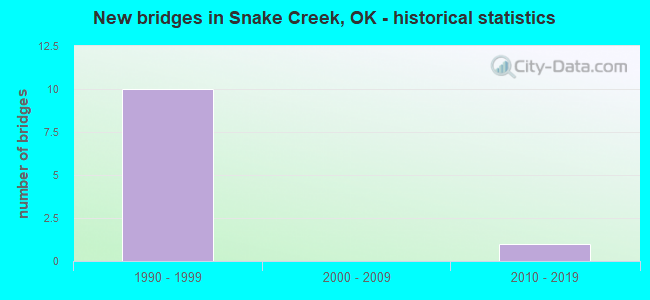
- New bridges - historical statistics
- 101990-1999
- 12010-2019


- Bridge Condition - Deck
- 85.7%Good
- 14.3%Fair

- Bridge Condition - Superstructure
- 71.4%Very good
- 14.3%Satisfactory
- 14.3%Poor

- Bridge Condition - Substructure
- 14.3%Very good
- 71.4%Good
- 14.3%Fair

- Bridge Condition - Channel
- 60.0%Very good
- 40.0%Fair
Find on map >> Show street view
Structure Number: 22924, Location: 5.96 MI.NE OF TP GATE (Lat: 36.190636, Lng: -95.127467), Route carried "on" structure: County highway , Year Built: 1991, Status: Open, Structure Length: 8.66m (28.41ft), Average Daily Traffic: 5,000 (year 2020), Truck Traffic: 15%, Average Future Daily Traffic: 8,000 (year 2040), Design Load: HS 20, Features Intersected: CHEROKEE TP UNDER, Facility Carried by Structure: CO. RD. E0570
Minimum Vertical Clearance: 30+ m (98+ ft), Kilometerpoint: 13.789, Lanes on structure: 2, Lanes under structure: 4, Owner: State Toll Authority, Approaching Roadway Width: 9.1m (29.9ft), Skew: 3 degrees, Material/Design: Prestressed concrete continuous, Design/Construction: Stringer/Multi-beam, Number Of Spans In Main Unit: 4, Length of Maximum Span: 26.8m (87.9ft), Curb-To-Curb Width: 9.1m (29.9ft), Out-to-Out Width: 9.8m (32.2ft)
Condition: Deck: Good, Superstructure: Very good, Substructure: Good, Operating Rating: 44.1 metric tons, Method Used To Determine Operating Rating: Load Factor (LF), Inventory Rating: 26.4 metric tons, Method Used To Determine Inventory Rating: Load Factor (LF), Structural Evaluation: Equal to present minimum criteria, Deck Geometry: Meets minimum limits, Underclear: Equal to present minimum criteria, Approach Roadway Alignment: Better than present minimum criteria, Length Of Structure Improvement: 8.66m (28.41ft), Designated Inspection Frequency: Every 24 months, Inspection Date: September 2020, Bridge Improvement Cost: $1,082,000, Roadway Improvement Cost: $1,250,000, Total Project Cost: $2,663,000 ( Estimate for 2015), Deck Structure Type: Concrete Cast-file-Place, Wearing Surface/Protective System: Wearing Surface: Monolithic Concrete, Deck Protection: Epoxy Coated Reinforcing
Find on map >> Show street view
Structure Number: 22928, Location: 9.45 MI.NE OF TP GATE (Lat: 36.200258, Lng: -95.118608), Route carried "on" structure: County highway , Year Built: 1991, Status: Open, Structure Length: 9.27m (30.41ft), Average Daily Traffic: 5,000 (year 2020), Truck Traffic: 15%, Average Future Daily Traffic: 8,000 (year 2040), Design Load: HS 20, Features Intersected: CHEROKEE TP UNDER, Facility Carried by Structure: CO. RD. N4430
Minimum Vertical Clearance: 30+ m (98+ ft), Kilometerpoint: 14.433, Lanes on structure: 2, Lanes under structure: 4, Owner: State Toll Authority, Approaching Roadway Width: 9.1m (29.9ft), Skew: 3 degrees, Material/Design: Prestressed concrete, Design/Construction: Stringer/Multi-beam, Number Of Spans In Main Unit: 4, Length of Maximum Span: 29.9m (98.1ft), Curb-To-Curb Width: 9.1m (29.9ft), Out-to-Out Width: 9.8m (32.2ft)
Condition: Deck: Good, Superstructure: Very good, Substructure: Good, Operating Rating: 35.2 metric tons, Method Used To Determine Operating Rating: Load Factor (LF), Inventory Rating: 21.0 metric tons, Method Used To Determine Inventory Rating: Load Factor (LF), Structural Evaluation: Somewhat better than minimum adequacy, Deck Geometry: Meets minimum limits, Underclear: Equal to present minimum criteria, Approach Roadway Alignment: Better than present minimum criteria, Length Of Structure Improvement: 9.27m (30.41ft), Designated Inspection Frequency: Every 24 months, Inspection Date: September 2020, Bridge Improvement Cost: $1,158,000, Roadway Improvement Cost: $1,250,000, Total Project Cost: $2,748,000 ( Estimate for 2015), Deck Structure Type: Concrete Cast-file-Place, Wearing Surface/Protective System: Wearing Surface: Monolithic Concrete, Deck Protection: Epoxy Coated Reinforcing
Find on map >> Show street view
Structure Number: 22929, Location: 10.6 MI.NE OF TP GATE (Lat: 36.210714, Lng: -95.100736), Route carried "on" structure: County highway , Year Built: 1991, Status: Open, Structure Length: 7.56m (24.80ft), Average Daily Traffic: 500 (year 2020), Truck Traffic: 15%, Average Future Daily Traffic: 800 (year 2040), Design Load: HS 20, Features Intersected: CHEROKEE TP UNDER, Facility Carried by Structure: CO. RD. N4440
Minimum Vertical Clearance: 30+ m (98+ ft), Kilometerpoint: 17.201, Lanes on structure: 2, Lanes under structure: 4, Owner: State Toll Authority, Approaching Roadway Width: 9.1m (29.9ft), Skew: 1 degrees, Material/Design: Prestressed concrete continuous, Design/Construction: Stringer/Multi-beam, Number Of Spans In Main Unit: 2, Number Of Approach Spans: 2, Length of Maximum Span: 24.4m (80.1ft), Curb-To-Curb Width: 9.1m (29.9ft), Out-to-Out Width: 9.8m (32.2ft)
Condition: Deck: Good, Superstructure: Very good, Substructure: Good, Operating Rating: 50.2 metric tons, Method Used To Determine Operating Rating: Load Factor (LF), Inventory Rating: 30.0 metric tons, Method Used To Determine Inventory Rating: Load Factor (LF), Structural Evaluation: Better than present minimum criteria, Deck Geometry: Equal to present minimum criteria, Underclear: Equal to present minimum criteria, Approach Roadway Alignment: Equal to present minimum criteria, Length Of Structure Improvement: 7.56m (24.80ft), Designated Inspection Frequency: Every 24 months, Inspection Date: September 2020, Bridge Improvement Cost: $944,000, Roadway Improvement Cost: $1,250,000, Total Project Cost: $2,506,000 ( Estimate for 2015), Deck Structure Type: Concrete Cast-file-Place, Wearing Surface/Protective System: Wearing Surface: Monolithic Concrete, Deck Protection: Epoxy Coated Reinforcing
Find on map >> Show street view
Structure Number: 22934, Location: 11.5 MI.NE OF TP GATE (Lat: 36.211828, Lng: -95.085675), Route carried "on" structure: Other road 412, Year Built: 1991, Status: Open, Structure Length: 9.14m (29.99ft), Average Daily Traffic: 6,100 (year 2020), Truck Traffic: 25%, Average Future Daily Traffic: 9,760 (year 2040), Design Load: HS 20, Features Intersected: LITTLE SPRING CREEK, Facility Carried by Structure: CHEROKEE TP
Minimum Vertical Clearance: 30+ m (98+ ft), Kilometerpoint: 28.743, Lanes on structure: 2, Base Highway Network: Yes, Toll: On toll road, Owner: State Toll Authority, Approaching Roadway Width: 14.0m (45.9ft), Skew: 13 degrees, Material/Design: Prestressed concrete continuous, Design/Construction: Stringer/Multi-beam, Number Of Spans In Main Unit: 3, Length of Maximum Span: 30.5m (100.1ft), Curb-To-Curb Width: 12.2m (40.0ft), Out-to-Out Width: 13.0m (42.7ft)
Condition: Deck: Good, Superstructure: Very good, Substructure: Good, Channel: Very good, Operating Rating: 44.5 metric tons, Method Used To Determine Operating Rating: Allowable Stress (AS), Inventory Rating: 32.7 metric tons, Method Used To Determine Inventory Rating: Allowable Stress (AS), Structural Evaluation: Better than present minimum criteria, Deck Geometry: Better than present minimum criteria, Waterway Adequacy: Superior to present desirable criteria, Approach Roadway Alignment: Equal to present desirable criteria, Length Of Structure Improvement: 11.15m (36.58ft), Designated Inspection Frequency: Every 24 months, Inspection Date: September 2020, Bridge Improvement Cost: $858,000, Roadway Improvement Cost: $1,250,000, Total Project Cost: $2,409,000 ( Estimate for 2015), Deck Structure Type: Concrete Cast-file-Place, Wearing Surface/Protective System: Wearing Surface: Monolithic Concrete, Deck Protection: Epoxy Coated Reinforcing
Find on map >> Show street view
Structure Number: 23922, Location: MAYES CL 1.2 E. OF NW COR (Lat: 36.161531, Lng: -95.098397), Route carried "on" structure: County highway 1117, Year Built: 1994, Status: Posted for load, Structure Length: 1.23m (4.04ft), Average Daily Traffic: 133 (year 2020), Truck Traffic: 15%, Average Future Daily Traffic: 213 (year 2040), Design Load: H 20, Features Intersected: SNAKE CREEK TRIB., Facility Carried by Structure: IRON POST RD.
Minimum Vertical Clearance: 30+ m (98+ ft), Kilometerpoint: 1.931, Lanes on structure: 2, Owner: County Highway Agency, Approaching Roadway Width: 6.1m (20.0ft), Material/Design: Steel continuous, Design/Construction: Stringer/Multi-beam, Number Of Spans In Main Unit: 2, Length of Maximum Span: 5.8m (19.0ft), Curb-To-Curb Width: 7.3m (24.0ft), Out-to-Out Width: 7.3m (24.0ft)
Condition: Deck: Fair, Superstructure: Poor, Substructure: Fair, Channel: Fair, Operating Rating: 27.2 metric tons, Method Used To Determine Operating Rating: Load Factor (LF), Inventory Rating: 16.3 metric tons, Method Used To Determine Inventory Rating: Load Factor (LF), Structural Evaluation: Meets minimum limits, Deck Geometry: Somewhat better than minimum adequacy, Waterway Adequacy: Equal to present desirable criteria, Approach Roadway Alignment: Equal to present minimum criteria, Bridge Posting: Required (Relationship of Operating Rating to Maximum Legal Load: 0.1 - 9.9% below), Length Of Structure Improvement: 3.73m (12.24ft), Designated Inspection Frequency: Every 24 months, Inspection Date: August 2021, Bridge Improvement Cost: $191,000, Roadway Improvement Cost: $105,000, Total Project Cost: $303,000 ( Estimate for 2015), Deck Structure Type: Concrete Cast-file-Place, Wearing Surface/Protective System: Wearing Surface: Bituminous
Find on map >> Show street view
Structure Number: 23941, Location: 11.6 MI.NE OF TP GATE (Lat: 36.212117, Lng: -95.085417), Route carried "on" structure: Other road 412, Year Built: 1991, Status: Open, Structure Length: 9.14m (29.99ft), Average Daily Traffic: 6,100 (year 2020), Truck Traffic: 25%, Average Future Daily Traffic: 9,760 (year 2040), Design Load: HS 20, Features Intersected: LITTLE SPRING CREEK, Facility Carried by Structure: CHEROKEE TP
Minimum Vertical Clearance: 30+ m (98+ ft), Kilometerpoint: 28.769, Lanes on structure: 2, Base Highway Network: Yes, Toll: On toll road, Owner: State Toll Authority, Approaching Roadway Width: 14.0m (45.9ft), Skew: 13 degrees, Material/Design: Prestressed concrete continuous, Design/Construction: Stringer/Multi-beam, Number Of Spans In Main Unit: 3, Length of Maximum Span: 30.5m (100.1ft), Curb-To-Curb Width: 12.2m (40.0ft), Out-to-Out Width: 13.0m (42.7ft)
Condition: Deck: Good, Superstructure: Very good, Substructure: Good, Channel: Very good, Operating Rating: 44.5 metric tons, Method Used To Determine Operating Rating: Allowable Stress (AS), Inventory Rating: 32.7 metric tons, Method Used To Determine Inventory Rating: Allowable Stress (AS), Structural Evaluation: Better than present minimum criteria, Deck Geometry: Better than present minimum criteria, Waterway Adequacy: Superior to present desirable criteria, Approach Roadway Alignment: Equal to present desirable criteria, Length Of Structure Improvement: 11.15m (36.58ft), Designated Inspection Frequency: Every 24 months, Inspection Date: September 2020, Bridge Improvement Cost: $858,000, Roadway Improvement Cost: $1,250,000, Total Project Cost: $2,409,000 ( Estimate for 2015), Deck Structure Type: Concrete Cast-file-Place, Wearing Surface/Protective System: Wearing Surface: Monolithic Concrete, Deck Protection: Epoxy Coated Reinforcing
Find on map >> Show street view
Structure Number: 23946, Location: 9.9 MI E OF TP GATE (Lat: 36.204350, Lng: -95.112372), Route carried "on" structure: Other road 412, Year Built: 1991, Status: Open, Structure Length: 1.22m (4.00ft), Average Daily Traffic: 6,100 (year 2020), Truck Traffic: 25%, Average Future Daily Traffic: 9,760 (year 2040), Design Load: HS 20, Features Intersected: CREEK, Facility Carried by Structure: CHEROKEE TP
Minimum Vertical Clearance: 30+ m (98+ ft), Kilometerpoint: 24.470, Lanes on structure: 4, Base Highway Network: Yes, Toll: On toll road, Owner: State Toll Authority, Approaching Roadway Width: 33.2m (108.9ft), Skew: 13 degrees, Material/Design: Concrete, Design/Construction: Culvert, Number Of Spans In Main Unit: 3, Length of Maximum Span: 3.0m (9.8ft), Curb-To-Curb Width: 114.3m (375.0ft), Out-to-Out Width: 114.9m (377.0ft)
Condition: Channel: Very good, Culverts: Good, Operating Rating: 44.5 metric tons, Method Used To Determine Operating Rating: Allowable Stress (AS), Inventory Rating: 32.7 metric tons, Method Used To Determine Inventory Rating: Allowable Stress (AS), Structural Evaluation: Better than present minimum criteria, Deck Geometry: Superior to present desirable criteria, Waterway Adequacy: Equal to present desirable criteria, Approach Roadway Alignment: Equal to present desirable criteria, Length Of Structure Improvement: 4.46m (14.63ft), Designated Inspection Frequency: Every 24 months, Inspection Date: September 2020, Bridge Improvement Cost: $200,000, Roadway Improvement Cost: $150,000, Total Project Cost: $360,000 ( Estimate for 2015)
Find on map >> Show street view
Structure Number: 31713, Location: 3E OF US412/SH82 (Lat: 36.195278, Lng: -95.105000), Route carried "on" structure: County highway E0563, Year Built: 2015, Status: Open, Structure Length: 2.80m (9.19ft), Average Daily Traffic: 100 (year 2020), Truck Traffic: 10%, Average Future Daily Traffic: 160 (year 2040), Design Load: HS 20, Features Intersected: SNAKE CREEK
Minimum Vertical Clearance: 30+ m (98+ ft), Kilometerpoint: 1.448, Lanes on structure: 2, Owner: County Highway Agency, Approaching Roadway Width: 8.5m (27.9ft), Material/Design: Concrete, Design/Construction: Frame, Number Of Spans In Main Unit: 3, Length of Maximum Span: 9.1m (29.9ft), Curb-To-Curb Width: 7.9m (25.9ft), Out-to-Out Width: 8.5m (27.9ft)
Condition: Deck: Good, Superstructure: Satisfactory, Substructure: Very good, Channel: Fair, Operating Rating: 67.6 metric tons, Method Used To Determine Operating Rating: Load Factor (LF), Inventory Rating: 40.6 metric tons, Method Used To Determine Inventory Rating: Load Factor (LF), Structural Evaluation: Equal to present minimum criteria, Deck Geometry: Equal to present minimum criteria, Waterway Adequacy: Equal to present minimum criteria, Approach Roadway Alignment: Equal to present desirable criteria, Designated Inspection Frequency: Every 24 months, Inspection Date: March 2021, Deck Structure Type: Concrete Precast Panels, Wearing Surface/Protective System: Wearing Surface: Bituminous
Find on map >> Show street view
Structure Number: 22924, Location: 5.96 MI.NE OF TP GATE (Lat: 36.190636, Lng: -95.127467), Route carried "under" structure: Other road 412, Year Built: 1991, Structure Length: 0. m, Average Daily Traffic: 6,100 (year 2020), Truck Traffic: 25%, Features Intersected: CHEROKEE TP UNDER, Facility Carried by Structure: CO. RD. E0570
Minimum Vertical Clearance: 5.28m (17.32ft), Kilometerpoint: 13.789, Lanes on structure: 2, Lanes under structure: 4, Toll: On toll road, Material/Design: Prestressed concrete continuous, Design/Construction: Stringer/Multi-beam, Length of Maximum Span: 26.8m (87.9ft)
Find on map >> Show street view
Structure Number: 22928, Location: 9.45 MI.NE OF TP GATE (Lat: 36.200258, Lng: -95.118608), Route carried "under" structure: Other road 412, Year Built: 1991, Structure Length: 0. m, Average Daily Traffic: 6,100 (year 2020), Truck Traffic: 25%, Features Intersected: CHEROKEE TP UNDER, Facility Carried by Structure: CO. RD. N4430
Minimum Vertical Clearance: 5.05m (16.57ft), Kilometerpoint: 14.433, Lanes on structure: 2, Lanes under structure: 4, Toll: On toll road, Material/Design: Prestressed concrete, Design/Construction: Stringer/Multi-beam, Length of Maximum Span: 29.9m (98.1ft)
Find on map >> Show street view
Structure Number: 22929, Location: 10.6 MI.NE OF TP GATE (Lat: 36.210714, Lng: -95.100736), Route carried "under" structure: Other road 412, Year Built: 1991, Structure Length: 0. m, Average Daily Traffic: 6,100 (year 2020), Truck Traffic: 25%, Features Intersected: CHEROKEE TP UNDER, Facility Carried by Structure: CO. RD. N4440
Minimum Vertical Clearance: 5.31m (17.42ft), Kilometerpoint: 17.201, Lanes on structure: 2, Lanes under structure: 4, Toll: On toll road, Material/Design: Prestressed concrete continuous, Design/Construction: Stringer/Multi-beam, Length of Maximum Span: 24.4m (80.1ft)