Bridge Statistics for Snydertown, Pennsylvania (PA)
Condition, Traffic, Stress, Structural Evaluation, Project Costs
- National Bridge Inventory (NBI) Statistics
- 14Number of bridges
- 79ft / 24.4mTotal length
- $967,000Total costs
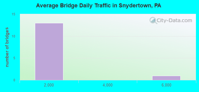
- 11,740Total average daily traffic
- 656Total average daily truck traffic
- 14,950Total future (year 2032) average daily traffic
- National Bridge Inventory (NBI) Registered Bridges for Snydertown
- No street view available for this location
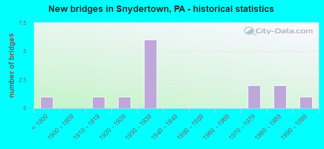
- New bridges - historical statistics
- 1Before 1900
- 11910-1919
- 11920-1929
- 61930-1939
- 21970-1979
- 21980-1989
- 11990-1999

- Reconstructed bridges - Historical Statistics
- 41980-1989
- 11990-1999
- 32000-2009
- 12010-2019
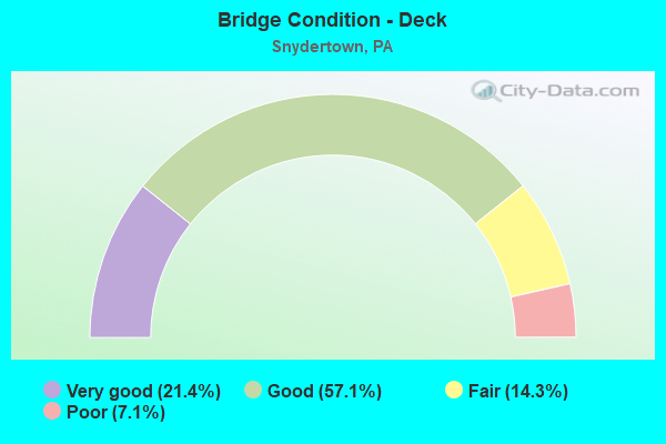
- Bridge Condition - Deck
- 21.4%Very good
- 57.1%Good
- 14.3%Fair
- 7.1%Poor
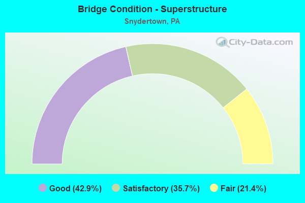
- Bridge Condition - Superstructure
- 42.9%Good
- 35.7%Satisfactory
- 21.4%Fair
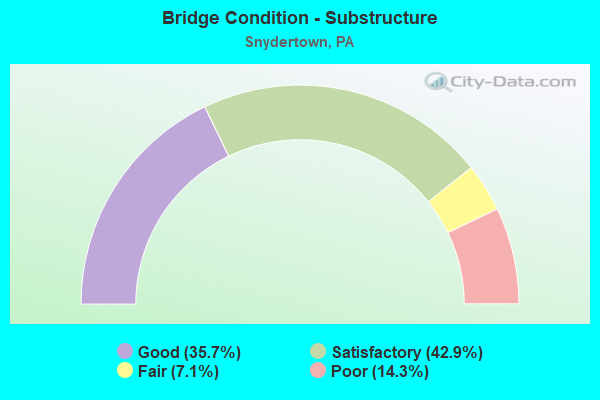
- Bridge Condition - Substructure
- 35.7%Good
- 42.9%Satisfactory
- 7.1%Fair
- 14.3%Poor
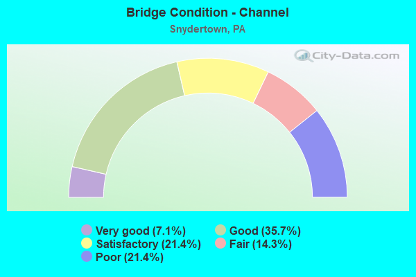
- Bridge Condition - Channel
- 7.1%Very good
- 35.7%Good
- 21.4%Satisfactory
- 14.3%Fair
- 21.4%Poor
Find on map >> Show street view
Structure Number: 29004, Location: VILLAGE OF STONINGTON (Lat: 40.852178, Lng: -76.671544), Route carried "on" structure: State highway 61, Year Built: 1938, Year Reconstructed: 1986, Status: Open, Structure Length: 1.13m (3.71ft), Average Daily Traffic: 5,968 (year 2021), Truck Traffic: 6%, Average Future Daily Traffic: 7,443 (year 2032), Features Intersected: OVER LICK RUN
Minimum Vertical Clearance: 30+ m (98+ ft), Kilometerpoint: 30.096, Lanes on structure: 2, Base Highway Network: Yes, Owner: State Highway Agency, Approaching Roadway Width: 11.6m (38.1ft), Skew: 3 degrees, Material/Design: Concrete, Design/Construction: Tee Beam, Number Of Spans In Main Unit: 1, Length of Maximum Span: 11.0m (36.1ft), Curb-To-Curb Width: 11.6m (38.1ft), Out-to-Out Width: 12.8m (42.0ft)
Condition: Deck: Fair, Superstructure: Fair, Substructure: Fair, Channel: Fair, Operating Rating: 43.5 metric tons, Method Used To Determine Operating Rating: Load Factor (LF), Inventory Rating: 26.3 metric tons, Method Used To Determine Inventory Rating: Load Factor (LF), Structural Evaluation: Somewhat better than minimum adequacy, Deck Geometry: Somewhat better than minimum adequacy, Waterway Adequacy: Equal to present minimum criteria, Approach Roadway Alignment: Equal to present desirable criteria, Length Of Structure Improvement: 1.20m (3.94ft), Designated Inspection Frequency: Every 24 months, Inspection Date: December 2020, Bridge Improvement Cost: $10,000, Roadway Improvement Cost: $50,000, Total Project Cost: $132,000, Deck Structure Type: Concrete Cast-file-Place, Wearing Surface/Protective System: Wearing Surface: Bituminous, Membrane: Preformed Fabric
Find on map >> Show street view
Structure Number: 29191, Location: 2 MI E OF SNYDERTOWN (Lat: 40.877458, Lng: -76.629181), Route carried "on" structure: State highway , Year Built: 1974, Year Reconstructed: 2009, Status: Open, Structure Length: 5.00m (16.40ft), Average Daily Traffic: 118 (year 2021), Truck Traffic: 4%, Average Future Daily Traffic: 563 (year 2032), Design Load: HS 20, Features Intersected: OVER SHAMOKIN CREEK, Facility Carried by Structure: SR 2007
Minimum Vertical Clearance: 30+ m (98+ ft), Kilometerpoint: 0.784, Lanes on structure: 2, Owner: State Highway Agency, Approaching Roadway Width: 11.0m (36.1ft), Skew: 2 degrees, Material/Design: Prestressed concrete, Design/Construction: Box Beam or Girders - Multiple, Number Of Spans In Main Unit: 2, Length of Maximum Span: 24.4m (80.1ft), Curb or Sidewalk Widths: Left: 0.2m (0.7ft), Right: 0.2m (0.7ft), Curb-To-Curb Width: 11.0m (36.1ft), Out-to-Out Width: 12.3m (40.4ft)
Condition: Deck: Very good, Superstructure: Satisfactory, Substructure: Good, Channel: Satisfactory, Operating Rating: 82.6 metric tons, Method Used To Determine Operating Rating: Load Factor (LF), Inventory Rating: 25.4 metric tons, Method Used To Determine Inventory Rating: Load Factor (LF), Structural Evaluation: Equal to present minimum criteria, Deck Geometry: Equal to present desirable criteria, Waterway Adequacy: Superior to present desirable criteria, Approach Roadway Alignment: Equal to present desirable criteria, Length Of Structure Improvement: 5.00m (16.40ft), Designated Inspection Frequency: Every 24 months, Inspection Date: December 2020, Bridge Improvement Cost: $10,000, Roadway Improvement Cost: $50,000, Total Project Cost: $132,000, Deck Structure Type: Concrete Cast-file-Place, Wearing Surface/Protective System: Wearing Surface: Monolithic Concrete, Deck Protection: Epoxy Coated Reinforcing
Find on map >> Show street view
Structure Number: 29274, Location: 5 MI NE OF SUNBURY (Lat: 40.904061, Lng: -76.731875), Route carried "on" structure: State highway , Year Built: 1912, Year Reconstructed: 1980, Status: Open, Structure Length: 0.98m (3.22ft), Average Daily Traffic: 486 (year 2022), Truck Traffic: 5%, Average Future Daily Traffic: 528 (year 2032), Features Intersected: TRIB NORTH BR SUSQ RIVER, Facility Carried by Structure: S.R. 4004
Minimum Vertical Clearance: 30+ m (98+ ft), Kilometerpoint: 7.836, Lanes on structure: 2, Owner: State Highway Agency, Approaching Roadway Width: 7.3m (24.0ft), Material/Design: Steel, Design/Construction: Stringer/Multi-beam, Number Of Spans In Main Unit: 1, Length of Maximum Span: 9.1m (29.9ft), Curb-To-Curb Width: 5.8m (19.0ft), Out-to-Out Width: 6.7m (22.0ft)
Condition: Deck: Fair, Superstructure: Satisfactory, Substructure: Poor, Channel: Poor, Operating Rating: 74.4 metric tons, Method Used To Determine Operating Rating: Load Factor (LF), Inventory Rating: 44.5 metric tons, Method Used To Determine Inventory Rating: Load Factor (LF), Structural Evaluation: Meets minimum limits, Deck Geometry: High priority of replacement, Waterway Adequacy: Better than present minimum criteria, Approach Roadway Alignment: High priority of corrective action, Length Of Structure Improvement: 1.00m (3.28ft), Designated Inspection Frequency: Every 24 months, Inspection Date: November 2021, Bridge Improvement Cost: $16,000, Roadway Improvement Cost: $50,000, Total Project Cost: $210,000, Deck Structure Type: Closed Grating, Wearing Surface/Protective System: Wearing Surface: Bituminous
Find on map >> Show street view
Structure Number: 29277, Location: SNYDERTOWN BORO (Lat: 40.874236, Lng: -76.671686), Route carried "on" structure: State highway , Year Built: 1930, Status: Open, Structure Length: 2.35m (7.71ft), Average Daily Traffic: 678 (year 2020), Truck Traffic: 5%, Average Future Daily Traffic: 915 (year 2032), Design Load: H 10, Features Intersected: OVER SHAMOKIN CREEK, Facility Carried by Structure: SR 4005
Minimum Vertical Clearance: 30+ m (98+ ft), Kilometerpoint: 2.400, Lanes on structure: 2, Owner: State Highway Agency, Approaching Roadway Width: 7.0m (23.0ft), Material/Design: Steel, Design/Construction: Girder and Floorbeam System, Number Of Spans In Main Unit: 1, Length of Maximum Span: 22.3m (73.2ft), Curb or Sidewalk Widths: Left: 0.2m (0.7ft), Right: 0.2m (0.7ft), Curb-To-Curb Width: 6.9m (22.6ft), Out-to-Out Width: 7.5m (24.6ft)
Condition: Deck: Good, Superstructure: Satisfactory, Substructure: Satisfactory, Channel: Satisfactory, Operating Rating: 71.7 metric tons, Method Used To Determine Operating Rating: Load Factor (LF), Inventory Rating: 42.6 metric tons, Method Used To Determine Inventory Rating: Load Factor (LF), Structural Evaluation: Equal to present minimum criteria, Deck Geometry: Meets minimum limits, Waterway Adequacy: Better than present minimum criteria, Approach Roadway Alignment: Equal to present minimum criteria, Length Of Structure Improvement: 2.30m (7.55ft), Designated Inspection Frequency: Every 24 months, Critical Feature Inspection Frequency: Every 24 months, Inspection Date: June 2020, Critical Feature Inspection Date: June 2020, Deck Structure Type: Concrete Cast-file-Place, Wearing Surface/Protective System: Wearing Surface: Monolithic Concrete
Find on map >> Show street view
Structure Number: 29281, Location: 3 MI.E OF SUNBURY (Lat: 40.873694, Lng: -76.703350), Route carried "on" structure: State highway , Year Built: 1974, Year Reconstructed: 2011, Status: Open, Structure Length: 5.09m (16.70ft), Average Daily Traffic: 356 (year 2022), Truck Traffic: 6%, Average Future Daily Traffic: 426 (year 2032), Design Load: HS 20, Features Intersected: OVER SHAMOKIN CREEK, Facility Carried by Structure: SR 4007
Minimum Vertical Clearance: 30+ m (98+ ft), Kilometerpoint: 0.000, Lanes on structure: 2, Owner: State Highway Agency, Approaching Roadway Width: 6.7m (22.0ft), Material/Design: Prestressed concrete, Design/Construction: Box Beam or Girders - Multiple, Number Of Spans In Main Unit: 2, Length of Maximum Span: 25.0m (82.0ft), Curb or Sidewalk Widths: Left: 0.2m (0.7ft), Right: 0.2m (0.7ft), Curb-To-Curb Width: 13.0m (42.7ft), Out-to-Out Width: 14.1m (46.3ft)
Condition: Deck: Very good, Superstructure: Satisfactory, Substructure: Satisfactory, Channel: Poor, Inventory Rating: 33.6 metric tons, Method Used To Determine Inventory Rating: Assigned rating based on Load Factor Design (LFD) reported in metric tons, Structural Evaluation: Equal to present minimum criteria, Deck Geometry: Superior to present desirable criteria, Waterway Adequacy: Superior to present desirable criteria, Approach Roadway Alignment: Equal to present desirable criteria, Length Of Structure Improvement: 5.10m (16.73ft), Designated Inspection Frequency: Every 24 months, Inspection Date: November 2021, Bridge Improvement Cost: $3,000, Total Project Cost: $104,000, Wearing Surface/Protective System: Wearing Surface: Monolithic Concrete, Deck Protection: Epoxy Coated Reinforcing
Find on map >> Show street view
Structure Number: 2929, Location: 3 MI SW OF STONINGTON (Lat: 40.829058, Lng: -76.707769), Route carried "on" structure: State highway , Year Built: 1939, Year Reconstructed: 1994, Status: Open, Structure Length: 0.67m (2.20ft), Average Daily Traffic: 1,271 (year 2021), Truck Traffic: 6%, Average Future Daily Traffic: 1,390 (year 2032), Features Intersected: OVER PLUM CREEK, Facility Carried by Structure: SR 4013
Minimum Vertical Clearance: 30+ m (98+ ft), Kilometerpoint: 3.866, Lanes on structure: 2, Owner: State Highway Agency, Approaching Roadway Width: 6.7m (22.0ft), Skew: 4 degrees, Material/Design: Concrete, Design/Construction: Slab, Number Of Spans In Main Unit: 1, Length of Maximum Span: 6.1m (20.0ft), Curb-To-Curb Width: 7.2m (23.6ft), Out-to-Out Width: 7.8m (25.6ft)
Condition: Deck: Good, Superstructure: Good, Substructure: Satisfactory, Channel: Good, Operating Rating: 85.3 metric tons, Method Used To Determine Operating Rating: Load Factor (LF), Inventory Rating: 50.8 metric tons, Method Used To Determine Inventory Rating: Load Factor (LF), Structural Evaluation: Equal to present minimum criteria, Deck Geometry: High priority of corrective action, Waterway Adequacy: Better than present minimum criteria, Approach Roadway Alignment: Equal to present desirable criteria, Length Of Structure Improvement: 0.80m (2.62ft), Designated Inspection Frequency: Every 48 months, Inspection Date: December 2018, Wearing Surface/Protective System: Wearing Surface: Bituminous, Membrane: Preformed Fabric
Find on map >> Show street view
Structure Number: 29291, Location: 1.5 MI SW OF STONINGTON (Lat: 40.832422, Lng: -76.704672), Route carried "on" structure: State highway , Year Built: 1939, Year Reconstructed: 1997, Status: Open, Structure Length: 0.70m (2.30ft), Average Daily Traffic: 1,271 (year 2021), Truck Traffic: 6%, Average Future Daily Traffic: 1,126 (year 2032), Features Intersected: OVER PLUM CREEK, Facility Carried by Structure: SR 4013
Minimum Vertical Clearance: 30+ m (98+ ft), Kilometerpoint: 4.551, Lanes on structure: 2, Owner: State Highway Agency, Approaching Roadway Width: 6.4m (21.0ft), Skew: 4 degrees, Material/Design: Concrete, Design/Construction: Slab, Number Of Spans In Main Unit: 1, Length of Maximum Span: 6.7m (22.0ft), Curb or Sidewalk Widths: Left: 0.2m (0.7ft), Right: 0.2m (0.7ft), Curb-To-Curb Width: 7.3m (24.0ft), Out-to-Out Width: 7.7m (25.3ft)
Condition: Deck: Good, Superstructure: Good, Substructure: Good, Channel: Satisfactory, Operating Rating: 73.5 metric tons, Method Used To Determine Operating Rating: Load Factor (LF), Inventory Rating: 43.5 metric tons, Method Used To Determine Inventory Rating: Load Factor (LF), Structural Evaluation: Better than present minimum criteria, Deck Geometry: Meets minimum limits, Waterway Adequacy: Better than present minimum criteria, Approach Roadway Alignment: Equal to present desirable criteria, Length Of Structure Improvement: 1.40m (4.59ft), Designated Inspection Frequency: Every 48 months, Inspection Date: December 2018, Wearing Surface/Protective System: Wearing Surface: Bituminous, Membrane: Preformed Fabric, Deck Protection: Epoxy Coated Reinforcing
Find on map >> Show street view
Structure Number: 29294, Location: 2MI.SE OF HAMILTON (Lat: 40.847964, Lng: -76.730194), Route carried "on" structure: State highway , Year Built: 1939, Year Reconstructed: 1993, Status: Open, Structure Length: 0.70m (2.30ft), Average Daily Traffic: 792 (year 2022), Truck Traffic: 6%, Average Future Daily Traffic: 1,355 (year 2032), Features Intersected: TRIB TO PLUM CREEK, Facility Carried by Structure: SR 4016
Minimum Vertical Clearance: 30+ m (98+ ft), Kilometerpoint: 1.551, Lanes on structure: 2, Owner: State Highway Agency, Approaching Roadway Width: 6.7m (22.0ft), Material/Design: Concrete, Design/Construction: Slab, Number Of Spans In Main Unit: 1, Length of Maximum Span: 6.7m (22.0ft), Curb-To-Curb Width: 7.5m (24.6ft), Out-to-Out Width: 8.0m (26.2ft)
Condition: Deck: Good, Superstructure: Good, Substructure: Satisfactory, Channel: Good, Operating Rating: 73.5 metric tons, Method Used To Determine Operating Rating: Load Factor (LF), Inventory Rating: 43.5 metric tons, Method Used To Determine Inventory Rating: Load Factor (LF), Structural Evaluation: Equal to present minimum criteria, Deck Geometry: Meets minimum limits, Waterway Adequacy: Better than present minimum criteria, Approach Roadway Alignment: Equal to present desirable criteria, Length Of Structure Improvement: 0.70m (2.30ft), Designated Inspection Frequency: Every 24 months, Inspection Date: December 2020, Wearing Surface/Protective System: Wearing Surface: Bituminous, Membrane: Preformed Fabric, Deck Protection: Epoxy Coated Reinforcing
Find on map >> Show street view
Structure Number: 29359, Location: 0.9 MI NE SEVEN POINTS (Lat: 40.834558, Lng: -76.722333), Route carried "on" structure: City street , Year Built: 1920, Status: Posted for load, Structure Length: 0.79m (2.59ft), Average Daily Traffic: 75 (year 2020), Average Future Daily Traffic: 116 (year 2042), Design Load: HS 20, Features Intersected: TRIB.TO PLUM CREEK, Facility Carried by Structure: T-684 ROCKEFELLER
Minimum Vertical Clearance: 30+ m (98+ ft), Kilometerpoint: 0.000, Lanes on structure: 2, Owner: Town or Township Highway Agency, Approaching Roadway Width: 4.9m (16.1ft), Material/Design: Steel, Design/Construction: Stringer/Multi-beam, Number Of Spans In Main Unit: 1, Length of Maximum Span: 7.3m (24.0ft), Curb or Sidewalk Widths: Left: 0.2m (0.7ft), Right: 0.2m (0.7ft), Curb-To-Curb Width: 6.2m (20.3ft), Out-to-Out Width: 7.0m (23.0ft)
Condition: Deck: Poor, Superstructure: Fair, Substructure: Satisfactory, Channel: Fair, Operating Rating: 35.4 metric tons, Method Used To Determine Operating Rating: Load Factor (LF), Inventory Rating: 20.9 metric tons, Method Used To Determine Inventory Rating: Load Factor (LF), Structural Evaluation: Somewhat better than minimum adequacy, Deck Geometry: Somewhat better than minimum adequacy, Waterway Adequacy: Equal to present minimum criteria, Approach Roadway Alignment: Equal to present desirable criteria, Bridge Posting: Required (Relationship of Operating Rating to Maximum Legal Load: 20.0 - 29.9% below), Length Of Structure Improvement: 0.80m (2.62ft), Designated Inspection Frequency: Every 24 months, Other Special Inspection Frequency: Every 12 months, Inspection Date: March 2021, Other Special Inspection Date: March 2021, Bridge Improvement Cost: $6,000, Roadway Improvement Cost: $50,000, Total Project Cost: $86,000, Deck Structure Type: Concrete Cast-file-Place, Wearing Surface/Protective System: Wearing Surface: Bituminous
Find on map >> Show street view
Structure Number: 2936, Location: 1.5 MI NW OF SEVEN POINTS (Lat: 40.838889, Lng: -76.727789), Route carried "on" structure: City street , Year Built: 1989, Status: Open, Structure Length: 1.25m (4.10ft), Average Daily Traffic: 100 (year 2018), Average Future Daily Traffic: 155 (year 2039), Design Load: HS 20, Features Intersected: PLUM CREEK, Facility Carried by Structure: T-684
Minimum Vertical Clearance: 30+ m (98+ ft), Kilometerpoint: 0.000, Lanes on structure: 2, Owner: County Highway Agency, Approaching Roadway Width: 5.5m (18.0ft), Skew: 3 degrees, Material/Design: Prestressed concrete, Design/Construction: Box Beam or Girders - Multiple, Number Of Spans In Main Unit: 1, Length of Maximum Span: 11.6m (38.1ft), Curb or Sidewalk Widths: Left: 0.2m (0.7ft), Right: 0.2m (0.7ft), Curb-To-Curb Width: 7.6m (24.9ft), Out-to-Out Width: 8.6m (28.2ft)
Condition: Deck: Good, Superstructure: Good, Substructure: Good, Channel: Good, Inventory Rating: 53.5 metric tons, Method Used To Determine Inventory Rating: Load Factor (LF), Structural Evaluation: Better than present minimum criteria, Deck Geometry: Equal to present minimum criteria, Waterway Adequacy: Equal to present desirable criteria, Approach Roadway Alignment: Equal to present minimum criteria, Length Of Structure Improvement: 1.20m (3.94ft), Designated Inspection Frequency: Every 24 months, Inspection Date: Febuary 2020, Deck Structure Type: Concrete Cast-file-Place, Wearing Surface/Protective System: Wearing Surface: Monolithic Concrete, Deck Protection: Epoxy Coated Reinforcing
Find on map >> Show street view
Structure Number: 29361, Location: N OF SEVEN POINTS (Lat: 40.835200, Lng: -76.710117), Route carried "on" structure: City street T696, Year Built: 1939, Year Reconstructed: 2018, Status: Posted for load, Structure Length: 0.76m (2.49ft), Average Daily Traffic: 60 (year 2018), Truck Traffic: 3%, Average Future Daily Traffic: 93 (year 2040), Design Load: HS 20, Features Intersected: PLUM CREEK, Facility Carried by Structure: TWP RD T-696
Minimum Vertical Clearance: 30+ m (98+ ft), Kilometerpoint: 0.000, Lanes on structure: 2, Owner: County Highway Agency, Approaching Roadway Width: 3.7m (12.1ft), Material/Design: Steel, Design/Construction: Stringer/Multi-beam, Number Of Spans In Main Unit: 1, Length of Maximum Span: 6.4m (21.0ft), Curb or Sidewalk Widths: Left: 0.2m (0.7ft), Right: 0.2m (0.7ft), Curb-To-Curb Width: 4.6m (15.1ft), Out-to-Out Width: 4.9m (16.1ft)
Condition: Deck: Good, Superstructure: Fair, Substructure: Poor, Channel: Poor, Operating Rating: 20.9 metric tons, Method Used To Determine Operating Rating: Load Factor (LF), Inventory Rating: 12.7 metric tons, Method Used To Determine Inventory Rating: Load Factor (LF), Structural Evaluation: Meets minimum limits, Deck Geometry: High priority of replacement, Waterway Adequacy: Equal to present desirable criteria, Approach Roadway Alignment: Equal to present minimum criteria, Bridge Posting: Required (Relationship of Operating Rating to Maximum Legal Load: > 39.9% below), Length Of Structure Improvement: 1.50m (4.92ft), Designated Inspection Frequency: Every 24 months, Other Special Inspection Frequency: Every 12 months, Inspection Date: November 2021, Other Special Inspection Date: November 2021, Deck Structure Type: Wood or Timber
Find on map >> Show street view
Structure Number: 29375, Location: E OF SUNBURY (Lat: 40.870667, Lng: -76.723236), Route carried "on" structure: City street , Year Built: 1888, Year Reconstructed: 2013, Status: Posted for load, Structure Length: 3.02m (9.91ft), Average Daily Traffic: 50 (year 2018), Average Future Daily Traffic: 77 (year 2040), Design Load: H 20, Features Intersected: SHAMOKIN CREEK, Facility Carried by Structure: KEEFER STATION
Minimum Vertical Clearance: 3.43m (11.25ft), Kilometerpoint: 0.000, Lanes on structure: 1, Owner: County Highway Agency, Approaching Roadway Width: 4.6m (15.1ft), Material/Design: Wood or Timber, Design/Construction: Truss - Thru, Number Of Spans In Main Unit: 1, Length of Maximum Span: 28.3m (92.8ft), Curb or Sidewalk Widths: Left: 0.8m (2.6ft), Right: 0.8m (2.6ft), Curb-To-Curb Width: 3.7m (12.1ft), Out-to-Out Width: 5.7m (18.7ft)
Condition: Deck: Good, Superstructure: Satisfactory, Substructure: Satisfactory, Channel: Good, Operating Rating: 4.5 metric tons, Method Used To Determine Operating Rating: Allowable Stress (AS), Inventory Rating: 3.6 metric tons, Method Used To Determine Inventory Rating: Allowable Stress (AS), Structural Evaluation: High priority of corrective action, Deck Geometry: High priority of corrective action, Waterway Adequacy: Equal to present desirable criteria, Approach Roadway Alignment: High priority of corrective action, Bridge Posting: Required (Relationship of Operating Rating to Maximum Legal Load: > 39.9% below), Length Of Structure Improvement: 3.30m (10.83ft), Designated Inspection Frequency: Every 24 months, Other Special Inspection Frequency: Every 12 months, Inspection Date: May 2020, Other Special Inspection Date: May 2021, Bridge Improvement Cost: $17,000, Roadway Improvement Cost: $50,000, Total Project Cost: $225,000, Deck Structure Type: Wood or Timber
Find on map >> Show street view
Structure Number: 29418, Location: SNYDERTOWN BORO (Lat: 40.868561, Lng: -76.671567), Route carried "on" structure: City street , Year Built: 1988, Status: Open, Structure Length: 0.70m (2.30ft), Average Daily Traffic: 290 (year 2017), Truck Traffic: 2%, Average Future Daily Traffic: 448 (year 2039), Design Load: HS 20, Features Intersected: LICK RUN, Facility Carried by Structure: Clark Road
Minimum Vertical Clearance: 30+ m (98+ ft), Kilometerpoint: 0.000, Lanes on structure: 2, Owner: County Highway Agency, Approaching Roadway Width: 4.9m (16.1ft), Material/Design: Wood or Timber, Design/Construction: Stringer/Multi-beam, Number Of Spans In Main Unit: 1, Length of Maximum Span: 6.7m (22.0ft), Curb or Sidewalk Widths: Left: 0.3m (1.0ft), Right: 0.3m (1.0ft), Curb-To-Curb Width: 7.4m (24.3ft), Out-to-Out Width: 7.8m (25.6ft)
Condition: Deck: Good, Superstructure: Good, Substructure: Good, Channel: Good, Operating Rating: 87.1 metric tons, Method Used To Determine Operating Rating: Allowable Stress (AS), Inventory Rating: 67.1 metric tons, Method Used To Determine Inventory Rating: Allowable Stress (AS), Structural Evaluation: Better than present minimum criteria, Deck Geometry: Somewhat better than minimum adequacy, Waterway Adequacy: Equal to present desirable criteria, Approach Roadway Alignment: Equal to present desirable criteria, Length Of Structure Improvement: 0.70m (2.30ft), Designated Inspection Frequency: Every 24 months, Inspection Date: November 2021, Bridge Improvement Cost: $6,000, Roadway Improvement Cost: $17,000, Total Project Cost: $78,000, Deck Structure Type: Wood or Timber, Wearing Surface/Protective System: Wearing Surface: Bituminous
Find on map >> Show street view
Structure Number: 29419, Location: SNDRTWN FRIEDLINE R (Lat: 40.872392, Lng: -76.669900), Route carried "on" structure: City street , Year Built: 1994, Status: Open, Structure Length: 1.28m (4.20ft), Average Daily Traffic: 225 (year 2018), Truck Traffic: 5%, Average Future Daily Traffic: 315 (year 2040), Design Load: HS 20, Features Intersected: LICK RUN, Facility Carried by Structure: FRIEDLINE RD
Minimum Vertical Clearance: 30+ m (98+ ft), Kilometerpoint: 0.000, Lanes on structure: 2, Owner: County Highway Agency, Approaching Roadway Width: 6.1m (20.0ft), Skew: 1 degrees, Material/Design: Prestressed concrete, Design/Construction: Box Beam or Girders - Multiple, Number Of Spans In Main Unit: 1, Length of Maximum Span: 12.2m (40.0ft), Curb or Sidewalk Widths: Left: 0.2m (0.7ft), Right: 0.2m (0.7ft), Curb-To-Curb Width: 7.6m (24.9ft), Out-to-Out Width: 8.6m (28.2ft)
Condition: Deck: Very good, Superstructure: Good, Substructure: Good, Channel: Very good, Operating Rating: 92.5 metric tons, Method Used To Determine Operating Rating: Load Factor (LF), Inventory Rating: 45.4 metric tons, Method Used To Determine Inventory Rating: Load Factor (LF), Structural Evaluation: Better than present minimum criteria, Deck Geometry: Somewhat better than minimum adequacy, Waterway Adequacy: Superior to present desirable criteria, Approach Roadway Alignment: Equal to present desirable criteria, Length Of Structure Improvement: 1.90m (6.23ft), Designated Inspection Frequency: Every 24 months, Inspection Date: March 2020, Deck Structure Type: Concrete Cast-file-Place, Wearing Surface/Protective System: Wearing Surface: Monolithic Concrete, Deck Protection: Epoxy Coated Reinforcing