Bridge Statistics for Social Circle, Georgia (GA)
Condition, Traffic, Stress, Structural Evaluation, Project Costs
- National Bridge Inventory (NBI) Statistics
- 34Number of bridges
- 338ft / 103mTotal length
- $117,303,000Total costs
- 269,260Total average daily traffic
- 30,414Total average daily truck traffic
- National Bridge Inventory (NBI) Registered Bridges for Social Circle
- No street view available for this location
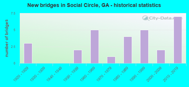
- New bridges - historical statistics
- 31920-1929
- 21950-1959
- 51960-1969
- 11970-1979
- 41980-1989
- 51990-1999
- 22000-2009
- 72010-2019


- Bridge Condition - Deck
- 13.3%Very good
- 80.0%Good
- 6.7%Satisfactory

- Bridge Condition - Superstructure
- 46.7%Very good
- 46.7%Good
- 6.7%Satisfactory

- Bridge Condition - Substructure
- 40.0%Very good
- 60.0%Good

- Bridge Condition - Channel
- 57.1%Very good
- 14.3%Good
- 28.6%Satisfactory

- Bridge Condition - Culverts
- 14.3%Very good
- 64.3%Good
- 21.4%Satisfactory
Find on map >> Show street view
Structure Number: 2110008, Location: 3.8 MI SW OF RUTLEDGE (Lat: 33.604469, Lng: -83.669878), Route carried "on" structure: County highway 46, Year Built: 1967, Status: Open, Structure Length: 8.02m (26.31ft), Average Daily Traffic: 140 (year 2010), Truck Traffic: 1%, Average Future Daily Traffic: 210 (year 2030), Design Load: H 15, Features Intersected: I-20, Facility Carried by Structure: SEWELL CHURCH RD
Minimum Vertical Clearance: 30+ m (98+ ft), Kilometerpoint: 1.609, Lanes on structure: 2, Lanes under structure: 4, Base Highway Network: Yes, Owner: State Highway Agency, Approaching Roadway Width: 5.5m (18.0ft), Material/Design: Steel continuous, Design/Construction: Stringer/Multi-beam, Number Of Spans In Main Unit: 4, Length of Maximum Span: 21.3m (69.9ft), Curb or Sidewalk Widths: Left: 0.6m (2.0ft), Right: 0.6m (2.0ft), Curb-To-Curb Width: 7.3m (24.0ft), Out-to-Out Width: 9.4m (30.8ft)
Condition: Deck: Good, Superstructure: Good, Substructure: Good, Operating Rating: 37.1 metric tons, Method Used To Determine Operating Rating: Load Factor (LF), Inventory Rating: 22.6 metric tons, Method Used To Determine Inventory Rating: Load Factor (LF), Structural Evaluation: Equal to present minimum criteria, Deck Geometry: Somewhat better than minimum adequacy, Underclear: Meets minimum limits, Approach Roadway Alignment: Equal to present minimum criteria, Designated Inspection Frequency: Every 24 months, Inspection Date: September 2020, Bridge Improvement Cost: $1,028,000, Roadway Improvement Cost: $103,000, Total Project Cost: $1,541,000, Deck Structure Type: Concrete Cast-file-Place, Wearing Surface/Protective System: Wearing Surface: Epoxy Overlay
Find on map >> Show street view
Structure Number: 2110021, Location: 3 MI SW OF RUTLEDGE (Lat: 33.600269, Lng: -83.651939), Route carried "on" structure: County highway 249, Year Built: 1967, Status: Open, Structure Length: 8.53m (27.99ft), Average Daily Traffic: 620 (year 2010), Truck Traffic: 1%, Average Future Daily Traffic: 930 (year 2030), Design Load: H 15, Features Intersected: I-20, Facility Carried by Structure: OLD MILL ROAD
Minimum Vertical Clearance: 30+ m (98+ ft), Kilometerpoint: 1.609, Lanes on structure: 2, Lanes under structure: 4, Base Highway Network: Yes, Owner: State Highway Agency, Approaching Roadway Width: 5.8m (19.0ft), Skew: 1 degrees, Material/Design: Steel continuous, Design/Construction: Stringer/Multi-beam, Number Of Spans In Main Unit: 4, Length of Maximum Span: 22.6m (74.1ft), Curb or Sidewalk Widths: Left: 0.6m (2.0ft), Right: 0.6m (2.0ft), Curb-To-Curb Width: 7.3m (24.0ft), Out-to-Out Width: 9.4m (30.8ft)
Condition: Deck: Good, Superstructure: Good, Substructure: Good, Operating Rating: 28.1 metric tons, Method Used To Determine Operating Rating: Load Factor (LF), Inventory Rating: 16.3 metric tons, Method Used To Determine Inventory Rating: Load Factor (LF), Structural Evaluation: Meets minimum limits, Deck Geometry: Meets minimum limits, Underclear: Somewhat better than minimum adequacy, Approach Roadway Alignment: Equal to present minimum criteria, Designated Inspection Frequency: Every 24 months, Inspection Date: September 2020, Bridge Improvement Cost: $1,094,000, Roadway Improvement Cost: $109,000, Total Project Cost: $1,641,000, Deck Structure Type: Concrete Cast-file-Place, Wearing Surface/Protective System: Wearing Surface: Epoxy Overlay
Find on map >> Show street view
Structure Number: 2110023, Location: 3.2 MI SW OF RUTLEDGE (Lat: 33.602469, Lng: -83.658589), Route carried "on" structure: Interstate 20, Year Built: 1966, Status: Open, Structure Length: 0.73m (2.40ft), Average Daily Traffic: 33,220 (year 2010), Truck Traffic: 12%, Average Future Daily Traffic: 49,830 (year 2030), Design Load: HS 20+Mod, Features Intersected: HUNNICUT CREEK
Minimum Vertical Clearance: 30+ m (98+ ft), Kilometerpoint: 165.762, Lanes on structure: 5, Base Highway Network: Yes, Owner: State Highway Agency, Approaching Roadway Width: 23.8m (78.1ft), Skew: 11 degrees, Material/Design: Concrete, Design/Construction: Culvert, Number Of Spans In Main Unit: 3, Length of Maximum Span: 2.1m (6.9ft)
Condition: Channel: Satisfactory, Culverts: Satisfactory, Structural Evaluation: Equal to present minimum criteria, Waterway Adequacy: Equal to present desirable criteria, Approach Roadway Alignment: Equal to present desirable criteria, Designated Inspection Frequency: Every 24 months, Inspection Date: September 2020, Bridge Improvement Cost: $170,000, Roadway Improvement Cost: $17,000, Total Project Cost: $256,000
Find on map >> Show street view
Structure Number: 2115057, Location: 4 MI S OF RUTLEDGE (Lat: 33.577628, Lng: -83.648600), Route carried "on" structure: County highway 2153, Year Built: 1996, Status: Open, Structure Length: 1.04m (3.41ft), Average Daily Traffic: 580 (year 2010), Truck Traffic: 1%, Average Future Daily Traffic: 870 (year 2030), Design Load: H 15, Features Intersected: HUNNICUT CREEK, Facility Carried by Structure: NEWBORN ROAD
Minimum Vertical Clearance: 30+ m (98+ ft), Kilometerpoint: 6.437, Lanes on structure: 2, Base Highway Network: Yes, Owner: County Highway Agency, Approaching Roadway Width: 7.0m (23.0ft), Material/Design: Steel, Design/Construction: Culvert, Number Of Spans In Main Unit: 3, Length of Maximum Span: 3.0m (9.8ft)
Condition: Channel: Very good, Culverts: Good, Operating Rating: 41.7 metric tons, Method Used To Determine Operating Rating: Field evaluation and documented engineering judgment, Inventory Rating: 24.4 metric tons, Method Used To Determine Inventory Rating: Field evaluation and documented engineering judgment, Structural Evaluation: Equal to present minimum criteria, Waterway Adequacy: Equal to present desirable criteria, Approach Roadway Alignment: Equal to present desirable criteria, Designated Inspection Frequency: Every 24 months, Inspection Date: August 2020, Bridge Improvement Cost: $133,000, Roadway Improvement Cost: $13,000, Total Project Cost: $199,000
Find on map >> Show street view
Structure Number: 2170005, Location: 6 MI E OF COVINGTON (Lat: 33.605078, Lng: -83.722669), Route carried "on" structure: US 278, Year Built: 1929, Status: Open, Structure Length: 0.79m (2.59ft), Average Daily Traffic: 2,150 (year 2011), Truck Traffic: 6%, Average Future Daily Traffic: 3,225 (year 2031), Design Load: H 15, Features Intersected: NELSON CREEK
Minimum Vertical Clearance: 30+ m (98+ ft), Kilometerpoint: 22.531, Lanes on structure: 2, Base Highway Network: Yes, Owner: State Highway Agency, Approaching Roadway Width: 7.3m (24.0ft), Material/Design: Concrete, Design/Construction: Culvert, Number Of Spans In Main Unit: 3, Length of Maximum Span: 2.4m (7.9ft), Curb-To-Curb Width: 9.1m (29.9ft), Out-to-Out Width: 10.0m (32.8ft)
Condition: Channel: Satisfactory, Culverts: Good, Operating Rating: 43.5 metric tons, Method Used To Determine Operating Rating: Load Factor (LF), Inventory Rating: 26.3 metric tons, Method Used To Determine Inventory Rating: Load Factor (LF), Structural Evaluation: Equal to present minimum criteria, Deck Geometry: Meets minimum limits, Waterway Adequacy: Equal to present minimum criteria, Approach Roadway Alignment: Better than present minimum criteria, Length Of Structure Improvement: 7.22m (23.69ft), Designated Inspection Frequency: Every 24 months, Inspection Date: January 2021, Bridge Improvement Cost: $102,000, Roadway Improvement Cost: $10,000, Total Project Cost: $152,000
Find on map >> Show street view
Structure Number: 2170006, Location: 7 MI E OF COVINGTON (Lat: 33.606900, Lng: -83.708958), Route carried "on" structure: US 278, Year Built: 1929, Status: Open, Structure Length: 0.98m (3.22ft), Average Daily Traffic: 2,150 (year 2011), Truck Traffic: 6%, Average Future Daily Traffic: 3,225 (year 2031), Design Load: H 15, Features Intersected: LITTLE RIVER
Minimum Vertical Clearance: 30+ m (98+ ft), Kilometerpoint: 24.140, Lanes on structure: 2, Base Highway Network: Yes, Owner: State Highway Agency, Approaching Roadway Width: 7.3m (24.0ft), Material/Design: Concrete, Design/Construction: Culvert, Number Of Spans In Main Unit: 3, Length of Maximum Span: 3.0m (9.8ft), Curb-To-Curb Width: 9.1m (29.9ft), Out-to-Out Width: 10.0m (32.8ft)
Condition: Channel: Satisfactory, Culverts: Good, Operating Rating: 59.8 metric tons, Method Used To Determine Operating Rating: Load Factor (LF), Inventory Rating: 36.2 metric tons, Method Used To Determine Inventory Rating: Load Factor (LF), Structural Evaluation: Better than present minimum criteria, Deck Geometry: Meets minimum limits, Waterway Adequacy: Equal to present minimum criteria, Approach Roadway Alignment: Equal to present minimum criteria, Length Of Structure Improvement: 41.21m (135.20ft), Designated Inspection Frequency: Every 24 months, Inspection Date: January 2021, Bridge Improvement Cost: $125,000, Roadway Improvement Cost: $13,000, Total Project Cost: $188,000
Find on map >> Show street view
Structure Number: 2170016, Location: 6.5 MI E OF COVINGTON (Lat: 33.611469, Lng: -83.720169), Route carried "on" structure: County highway 114, Year Built: 1964, Status: Posted for load, Structure Length: 8.47m (27.79ft), Average Daily Traffic: 70 (year 2011), Truck Traffic: 1%, Average Future Daily Traffic: 105 (year 2031), Design Load: H 15, Features Intersected: I-20, Facility Carried by Structure: SOCIAL CIRCLE RD
Minimum Vertical Clearance: 30+ m (98+ ft), Kilometerpoint: 0.000, Lanes on structure: 2, Lanes under structure: 4, Base Highway Network: Yes, Owner: State Highway Agency, Approaching Roadway Width: 5.5m (18.0ft), Skew: 2 degrees, Material/Design: Steel continuous, Design/Construction: Stringer/Multi-beam, Number Of Spans In Main Unit: 4, Length of Maximum Span: 23.8m (78.1ft), Curb or Sidewalk Widths: Left: 0.6m (2.0ft), Right: 0.6m (2.0ft), Curb-To-Curb Width: 7.3m (24.0ft), Out-to-Out Width: 9.2m (30.2ft)
Condition: Deck: Good, Superstructure: Good, Substructure: Very good, Operating Rating: 36.2 metric tons, Method Used To Determine Operating Rating: Load Factor (LF), Inventory Rating: 21.7 metric tons, Method Used To Determine Inventory Rating: Load Factor (LF), Structural Evaluation: Equal to present minimum criteria, Deck Geometry: Equal to present minimum criteria, Underclear: Meets minimum limits, Approach Roadway Alignment: Equal to present minimum criteria, Designated Inspection Frequency: Every 24 months, Inspection Date: Febuary 2021, Bridge Improvement Cost: $1,086,000, Roadway Improvement Cost: $109,000, Total Project Cost: $1,629,000, Deck Structure Type: Concrete Cast-file-Place, Wearing Surface/Protective System: Wearing Surface: Epoxy Overlay
Find on map >> Show street view
Structure Number: 2170039, Location: 6.5 MI E OF COVINGTON (Lat: 33.611719, Lng: -83.728939), Route carried "on" structure: Interstate 20, Year Built: 1964, Status: Open, Structure Length: 0.76m (2.49ft), Average Daily Traffic: 31,560 (year 2011), Truck Traffic: 1%, Average Future Daily Traffic: 47,340 (year 2031), Design Load: HS 20+Mod, Features Intersected: NELSON CREEK
Minimum Vertical Clearance: 30+ m (98+ ft), Kilometerpoint: 159.325, Lanes on structure: 4, Base Highway Network: Yes, Owner: State Highway Agency, Approaching Roadway Width: 23.2m (76.1ft), Skew: 14 degrees, Material/Design: Concrete, Design/Construction: Culvert, Number Of Spans In Main Unit: 2, Length of Maximum Span: 3.7m (12.1ft)
Condition: Channel: Satisfactory, Culverts: Good, Structural Evaluation: Better than present minimum criteria, Waterway Adequacy: Equal to present desirable criteria, Approach Roadway Alignment: Equal to present desirable criteria, Designated Inspection Frequency: Every 24 months, Inspection Date: Febuary 2021, Bridge Improvement Cost: $151,000, Roadway Improvement Cost: $15,000, Total Project Cost: $226,000
Find on map >> Show street view
Structure Number: 2175039, Location: 3 MI NE OF COVINGTON (Lat: 33.646519, Lng: -83.773039), Route carried "on" structure: County highway 278, Year Built: 1992, Status: Open, Structure Length: 1.52m (4.99ft), Average Daily Traffic: 970 (year 2011), Truck Traffic: 1%, Average Future Daily Traffic: 1,455 (year 2031), Design Load: HS 20+Mod, Features Intersected: STROUDS CREEK, Facility Carried by Structure: HAMBY LANE
Minimum Vertical Clearance: 30+ m (98+ ft), Kilometerpoint: 4.828, Lanes on structure: 2, Base Highway Network: Yes, Owner: County Highway Agency, Approaching Roadway Width: 6.7m (22.0ft), Skew: 3 degrees, Material/Design: Concrete, Design/Construction: Culvert, Number Of Spans In Main Unit: 4, Length of Maximum Span: 3.7m (12.1ft)
Condition: Channel: Good, Culverts: Satisfactory, Operating Rating: 55.3 metric tons, Method Used To Determine Operating Rating: Field evaluation and documented engineering judgment, Inventory Rating: 32.6 metric tons, Method Used To Determine Inventory Rating: Field evaluation and documented engineering judgment, Structural Evaluation: Equal to present minimum criteria, Waterway Adequacy: Equal to present desirable criteria, Approach Roadway Alignment: Better than present minimum criteria, Designated Inspection Frequency: Every 24 months, Inspection Date: Febuary 2021, Bridge Improvement Cost: $195,000, Roadway Improvement Cost: $20,000, Total Project Cost: $293,000
Find on map >> Show street view
Structure Number: 2175052, Location: 5.5 MI E OF COVINGTON (Lat: 33.612408, Lng: -83.750128), Route carried "on" structure: State highway 11, Year Built: 2003, Status: Open, Structure Length: 6.95m (22.80ft), Average Daily Traffic: 9,450 (year 2011), Truck Traffic: 1%, Average Future Daily Traffic: 14,175 (year 2031), Design Load: HS 20+Mod, Features Intersected: I-20
Minimum Vertical Clearance: 30+ m (98+ ft), Kilometerpoint: 17.703, Lanes on structure: 4, Lanes under structure: 4, Base Highway Network: Yes, Owner: State Highway Agency, Approaching Roadway Width: 19.8m (65.0ft), Skew: 2 degrees, Material/Design: Steel continuous, Design/Construction: Stringer/Multi-beam, Number Of Spans In Main Unit: 2, Length of Maximum Span: 34.7m (113.8ft), Curb or Sidewalk Widths: Left: 1.8m (5.9ft), Right: 1.8m (5.9ft), Curb-To-Curb Width: 19.6m (64.3ft), Out-to-Out Width: 23.9m (78.4ft)
Condition: Deck: Good, Superstructure: Good, Substructure: Good, Operating Rating: 58.0 metric tons, Method Used To Determine Operating Rating: Load Factor (LF), Inventory Rating: 34.4 metric tons, Method Used To Determine Inventory Rating: Load Factor (LF), Structural Evaluation: Better than present minimum criteria, Deck Geometry: Better than present minimum criteria, Underclear: Better than present minimum criteria, Approach Roadway Alignment: Superior to present desirable criteria, Designated Inspection Frequency: Every 24 months, Inspection Date: Febuary 2021, Bridge Improvement Cost: $1,377,000, Roadway Improvement Cost: $138,000, Total Project Cost: $2,065,000, Deck Structure Type: Concrete Cast-file-Place
Find on map >> Show street view
Structure Number: 2175053, Location: NEWTON-WALTON CO. LINE (Lat: 33.609469, Lng: -83.699478), Route carried "on" structure: US 278, Year Built: 2003, Status: Open, Structure Length: 7.32m (24.02ft), Average Daily Traffic: 2,730 (year 2011), Truck Traffic: 1%, Average Future Daily Traffic: 4,095 (year 2031), Design Load: HS 20+Mod, Features Intersected: I-20
Minimum Vertical Clearance: 30+ m (98+ ft), Kilometerpoint: 25.750, Lanes on structure: 2, Lanes under structure: 4, Base Highway Network: Yes, Owner: State Highway Agency, Approaching Roadway Width: 7.3m (24.0ft), Skew: 3 degrees, Material/Design: Steel continuous, Design/Construction: Stringer/Multi-beam, Number Of Spans In Main Unit: 2, Length of Maximum Span: 36.6m (120.1ft), Curb or Sidewalk Widths: Left: 1.8m (5.9ft), Right: 1.8m (5.9ft), Curb-To-Curb Width: 16.0m (52.5ft), Out-to-Out Width: 20.3m (66.6ft)
Condition: Deck: Good, Superstructure: Good, Substructure: Good, Operating Rating: 54.4 metric tons, Method Used To Determine Operating Rating: Load Factor (LF), Inventory Rating: 32.6 metric tons, Method Used To Determine Inventory Rating: Load Factor (LF), Structural Evaluation: Better than present minimum criteria, Deck Geometry: Superior to present desirable criteria, Underclear: Better than present minimum criteria, Approach Roadway Alignment: Superior to present desirable criteria, Designated Inspection Frequency: Every 24 months, Inspection Date: Febuary 2021, Bridge Improvement Cost: $938,000, Roadway Improvement Cost: $94,000, Total Project Cost: $1,407,000, Deck Structure Type: Concrete Cast-file-Place
Find on map >> Show street view
Structure Number: 217506, Location: AT THE MORGAN CO LINE (Lat: 33.573978, Lng: -83.679678), Route carried "on" structure: County highway 132, Year Built: 2014, Status: Open, Structure Length: 1.40m (4.59ft), Average Daily Traffic: 230 (year 2011), Truck Traffic: 1%, Average Future Daily Traffic: 345 (year 2031), Design Load: HS 20, Features Intersected: LITTLE RIVER
Minimum Vertical Clearance: 30+ m (98+ ft), Kilometerpoint: 0.000, Lanes on structure: 1, Base Highway Network: Yes, Owner: County Highway Agency, Approaching Roadway Width: 4.3m (14.1ft), Material/Design: Steel, Design/Construction: Stringer/Multi-beam, Number Of Spans In Main Unit: 1, Length of Maximum Span: 14.0m (45.9ft), Curb-To-Curb Width: 3.7m (12.1ft), Out-to-Out Width: 4.0m (13.1ft)
Condition: Deck: Good, Superstructure: Good, Substructure: Very good, Channel: Very good, Operating Rating: 42.6 metric tons, Method Used To Determine Operating Rating: Load Factor (LF), Inventory Rating: 25.4 metric tons, Method Used To Determine Inventory Rating: Load Factor (LF), Structural Evaluation: Equal to present minimum criteria, Deck Geometry: High priority of replacement, Waterway Adequacy: Equal to present minimum criteria, Approach Roadway Alignment: High priority of corrective action, Length Of Structure Improvement: 1.68m (5.51ft), Designated Inspection Frequency: Every 24 months, Inspection Date: January 2021, Bridge Improvement Cost: $4,085,000, Roadway Improvement Cost: $408,000, Total Project Cost: $6,128,000 ( Estimate for 2015), Deck Structure Type: Wood or Timber
Find on map >> Show street view
Structure Number: 2970016, Location: 4.5 MI N OF SOCIAL CIRCLE (Lat: 33.720069, Lng: -83.695719), Route carried "on" structure: State highway 11, Year Built: 1926, Status: Open, Structure Length: 0.64m (2.10ft), Average Daily Traffic: 6,030 (year 2012), Truck Traffic: 1%, Average Future Daily Traffic: 9,045 (year 2032), Design Load: H 15, Features Intersected: ROCKY CREEK
Minimum Vertical Clearance: 30+ m (98+ ft), Kilometerpoint: 9.656, Lanes on structure: 2, Base Highway Network: Yes, Owner: State Highway Agency, Approaching Roadway Width: 9.4m (30.8ft), Material/Design: Concrete, Design/Construction: Culvert, Number Of Spans In Main Unit: 2, Length of Maximum Span: 3.0m (9.8ft)
Condition: Channel: Very good, Culverts: Good, Structural Evaluation: Better than present minimum criteria, Waterway Adequacy: Equal to present desirable criteria, Approach Roadway Alignment: Equal to present desirable criteria, Designated Inspection Frequency: Every 24 months, Inspection Date: July 2021, Bridge Improvement Cost: $82,000, Roadway Improvement Cost: $8,000, Total Project Cost: $123,000
Find on map >> Show street view
Structure Number: 297004, Location: 3.2 M NW OF SOCIAL CIRCLE (Lat: 33.692900, Lng: -83.751169), Route carried "on" structure: County highway 1051, Year Built: 1958, Status: Posted for load, Structure Length: 6.95m (22.80ft), Average Daily Traffic: 1,680 (year 2012), Truck Traffic: 1%, Average Future Daily Traffic: 2,520 (year 2032), Design Load: H 15, Features Intersected: ALCOVY RIVER, Facility Carried by Structure: JERSEY SOC. CIR RD
Minimum Vertical Clearance: 30+ m (98+ ft), Kilometerpoint: 14.484, Lanes on structure: 2, Base Highway Network: Yes, Owner: County Highway Agency, Approaching Roadway Width: 7.3m (24.0ft), Material/Design: Concrete, Design/Construction: Tee Beam, Number Of Spans In Main Unit: 6, Length of Maximum Span: 11.6m (38.1ft), Curb or Sidewalk Widths: Left: 0.6m (2.0ft), Right: 0.6m (2.0ft), Curb-To-Curb Width: 7.3m (24.0ft), Out-to-Out Width: 9.1m (29.9ft)
Condition: Deck: Good, Superstructure: Good, Substructure: Good, Channel: Good, Operating Rating: 26.3 metric tons, Method Used To Determine Operating Rating: Load Factor (LF), Inventory Rating: 15.4 metric tons, Method Used To Determine Inventory Rating: Load Factor (LF), Structural Evaluation: Meets minimum limits, Deck Geometry: Meets minimum limits, Waterway Adequacy: Equal to present desirable criteria, Approach Roadway Alignment: Equal to present desirable criteria, Bridge Posting: Required (Relationship of Operating Rating to Maximum Legal Load: 10.0 - 19.9% below), Length Of Structure Improvement: 13.38m (43.90ft), Designated Inspection Frequency: Every 24 months, Underwater Inspection Frequency: Every 60 months, Inspection Date: July 2021, Underwater Inspection Date: April 2020, Bridge Improvement Cost: $242,000, Roadway Improvement Cost: $54,000, Total Project Cost: $400,000, Deck Structure Type: Concrete Cast-file-Place
Find on map >> Show street view
Structure Number: 2970041, Location: 3 MI NW OF SOCIAL CIRCLE (Lat: 33.691408, Lng: -83.749558), Route carried "on" structure: County highway 1051, Year Built: 1958, Status: Open, Structure Length: 0.64m (2.10ft), Average Daily Traffic: 1,680 (year 2012), Truck Traffic: 1%, Average Future Daily Traffic: 2,520 (year 2032), Design Load: H 15, Features Intersected: RICHLAND CREEK, Facility Carried by Structure: JERSEY SOC. CIR RD
Minimum Vertical Clearance: 30+ m (98+ ft), Kilometerpoint: 14.484, Lanes on structure: 2, Base Highway Network: Yes, Owner: County Highway Agency, Approaching Roadway Width: 7.3m (24.0ft), Material/Design: Concrete, Design/Construction: Culvert, Number Of Spans In Main Unit: 2, Length of Maximum Span: 3.0m (9.8ft)
Condition: Channel: Good, Culverts: Good, Operating Rating: 41.7 metric tons, Method Used To Determine Operating Rating: Field evaluation and documented engineering judgment, Inventory Rating: 24.4 metric tons, Method Used To Determine Inventory Rating: Field evaluation and documented engineering judgment, Structural Evaluation: Equal to present minimum criteria, Waterway Adequacy: Equal to present desirable criteria, Approach Roadway Alignment: Equal to present desirable criteria, Designated Inspection Frequency: Every 24 months, Inspection Date: July 2021, Bridge Improvement Cost: $82,000, Roadway Improvement Cost: $8,000, Total Project Cost: $123,000
Find on map >> Show street view
Structure Number: 2970042, Location: IN SOCIAL CIRCLE (Lat: 33.654297, Lng: -83.714847), Route carried "on" structure: County highway 1051, Year Built: 1986, Status: Open, Structure Length: 3.32m (10.89ft), Average Daily Traffic: 700 (year 2012), Truck Traffic: 1%, Average Future Daily Traffic: 1,050 (year 2032), Design Load: HS 20, Features Intersected: GREAT WALTON RAILROAD, Facility Carried by Structure: EAST HIGHTOWER TRL
Minimum Vertical Clearance: 30+ m (98+ ft), Kilometerpoint: 20.921, Lanes on structure: 2, Base Highway Network: Yes, Owner: County Highway Agency, Approaching Roadway Width: 6.1m (20.0ft), Skew: 3 degrees, Material/Design: Steel, Design/Construction: Stringer/Multi-beam, Number Of Spans In Main Unit: 3, Length of Maximum Span: 18.3m (60.0ft), Curb or Sidewalk Widths: Left: 1.8m (5.9ft), Right: 1.8m (5.9ft), Curb-To-Curb Width: 8.6m (28.2ft), Out-to-Out Width: 12.8m (42.0ft)
Condition: Deck: Satisfactory, Superstructure: Satisfactory, Substructure: Good, Operating Rating: 50.8 metric tons, Method Used To Determine Operating Rating: Load Factor (LF), Inventory Rating: 29.9 metric tons, Method Used To Determine Inventory Rating: Load Factor (LF), Structural Evaluation: Equal to present minimum criteria, Deck Geometry: Somewhat better than minimum adequacy, Underclear: High priority of corrective action, Approach Roadway Alignment: Equal to present desirable criteria, Designated Inspection Frequency: Every 24 months, Inspection Date: July 2021, Bridge Improvement Cost: $426,000, Roadway Improvement Cost: $43,000, Total Project Cost: $639,000, Deck Structure Type: Concrete Cast-file-Place
Find on map >> Show street view
Structure Number: 2970043, Location: CITY OF SOCIAL CIRCLE (Lat: 33.654019, Lng: -83.713428), Route carried "on" structure: County highway 1051, Year Built: 1970, Year Reconstructed: 2012, Status: Open, Structure Length: 2.77m (9.09ft), Average Daily Traffic: 700 (year 2012), Truck Traffic: 1%, Average Future Daily Traffic: 1,050 (year 2032), Features Intersected: CSX RAILROAD, Facility Carried by Structure: EAST HIGHTOWER TRL
Minimum Vertical Clearance: 30+ m (98+ ft), Kilometerpoint: 20.921, Lanes on structure: 2, Base Highway Network: Yes, Owner: County Highway Agency, Approaching Roadway Width: 6.4m (21.0ft), Material/Design: Steel, Design/Construction: Stringer/Multi-beam, Number Of Spans In Main Unit: 3, Length of Maximum Span: 10.4m (34.1ft), Curb-To-Curb Width: 7.3m (24.0ft), Out-to-Out Width: 8.0m (26.2ft)
Condition: Deck: Very good, Superstructure: Very good, Substructure: Good, Operating Rating: 76.2 metric tons, Method Used To Determine Operating Rating: Load Factor (LF), Inventory Rating: 45.3 metric tons, Method Used To Determine Inventory Rating: Load Factor (LF), Structural Evaluation: Better than present minimum criteria, Deck Geometry: Meets minimum limits, Underclear: Meets minimum limits, Approach Roadway Alignment: Equal to present minimum criteria, Length Of Structure Improvement: 43.01m (141.11ft), Designated Inspection Frequency: Every 24 months, Inspection Date: July 2021, Bridge Improvement Cost: $356,000, Roadway Improvement Cost: $36,000, Total Project Cost: $533,000, Deck Structure Type: Concrete Cast-file-Place
Find on map >> Show street view
Structure Number: 2975028, Location: 2.5 M NW OF SOCIAL CIRCLE (Lat: 33.682878, Lng: -83.744858), Route carried "on" structure: County highway 165, Year Built: 1988, Status: Open, Structure Length: 0.64m (2.10ft), Average Daily Traffic: 490 (year 2012), Truck Traffic: 1%, Average Future Daily Traffic: 735 (year 2032), Design Load: HS 20+Mod, Features Intersected: GIBBS CREEK, Facility Carried by Structure: CLEGG FARM ROAD
Minimum Vertical Clearance: 30+ m (98+ ft), Kilometerpoint: 0.000, Lanes on structure: 2, Base Highway Network: Yes, Owner: County Highway Agency, Approaching Roadway Width: 6.1m (20.0ft), Material/Design: Concrete, Design/Construction: Culvert, Number Of Spans In Main Unit: 2, Length of Maximum Span: 3.0m (9.8ft)
Condition: Channel: Very good, Culverts: Good, Operating Rating: 55.3 metric tons, Method Used To Determine Operating Rating: Field evaluation and documented engineering judgment, Inventory Rating: 32.6 metric tons, Method Used To Determine Inventory Rating: Field evaluation and documented engineering judgment, Structural Evaluation: Better than present minimum criteria, Waterway Adequacy: Equal to present desirable criteria, Approach Roadway Alignment: Equal to present desirable criteria, Designated Inspection Frequency: Every 24 months, Inspection Date: July 2021, Bridge Improvement Cost: $82,000, Roadway Improvement Cost: $8,000, Total Project Cost: $123,000
Find on map >> Show street view
Structure Number: 297507, Location: 3.5 MI NW OF MONROE (Lat: 33.820408, Lng: -83.761808), Route carried "on" structure: County highway 467, Year Built: 1981, Status: Open, Structure Length: 1.52m (4.99ft), Average Daily Traffic: 490 (year 2012), Truck Traffic: 3%, Average Future Daily Traffic: 735 (year 2032), Design Load: HS 20+Mod, Features Intersected: BEAVERDAM CREEK, Facility Carried by Structure: DOUBLE SPRINGS CH
Minimum Vertical Clearance: 30+ m (98+ ft), Kilometerpoint: 3.219, Lanes on structure: 2, Base Highway Network: Yes, Owner: County Highway Agency, Approaching Roadway Width: 6.4m (21.0ft), Skew: 3 degrees, Material/Design: Concrete, Design/Construction: Culvert, Number Of Spans In Main Unit: 4, Length of Maximum Span: 3.7m (12.1ft)
Condition: Channel: Satisfactory, Culverts: Satisfactory, Operating Rating: 55.3 metric tons, Method Used To Determine Operating Rating: Field evaluation and documented engineering judgment, Inventory Rating: 32.6 metric tons, Method Used To Determine Inventory Rating: Field evaluation and documented engineering judgment, Structural Evaluation: Equal to present minimum criteria, Waterway Adequacy: Equal to present desirable criteria, Approach Roadway Alignment: Meets minimum limits, Designated Inspection Frequency: Every 24 months, Inspection Date: August 2021, Bridge Improvement Cost: $195,000, Roadway Improvement Cost: $20,000, Total Project Cost: $293,000
Find on map >> Show street view
Structure Number: 2975072, Location: NW SOCIAL CIRCLE (Lat: 33.677369, Lng: -83.729747), Route carried "on" structure: County highway 1051, Year Built: 1989, Status: Open, Structure Length: 1.10m (3.61ft), Average Daily Traffic: 1,970 (year 2012), Truck Traffic: 1%, Average Future Daily Traffic: 2,955 (year 2032), Design Load: HS 20+Mod, Features Intersected: GIBBS CREEK, Facility Carried by Structure: WEST HIGHTOWER TRL
Minimum Vertical Clearance: 30+ m (98+ ft), Kilometerpoint: 17.703, Lanes on structure: 2, Base Highway Network: Yes, Owner: County Highway Agency, Approaching Roadway Width: 6.7m (22.0ft), Skew: 2 degrees, Material/Design: Concrete, Design/Construction: Culvert, Number Of Spans In Main Unit: 3, Length of Maximum Span: 3.4m (11.2ft)
Condition: Channel: Very good, Culverts: Good, Operating Rating: 55.3 metric tons, Method Used To Determine Operating Rating: Field evaluation and documented engineering judgment, Inventory Rating: 32.6 metric tons, Method Used To Determine Inventory Rating: Field evaluation and documented engineering judgment, Structural Evaluation: Better than present minimum criteria, Waterway Adequacy: Equal to present desirable criteria, Approach Roadway Alignment: Better than present minimum criteria, Designated Inspection Frequency: Every 24 months, Inspection Date: July 2021, Bridge Improvement Cost: $141,000, Roadway Improvement Cost: $14,000, Total Project Cost: $211,000
Find on map >> Show street view
Structure Number: 2975078, Location: 2.8 MI E OF SOCIAL CIRCLE (Lat: 33.665358, Lng: -83.672658), Route carried "on" structure: County highway 210, Year Built: 1994, Status: Open, Structure Length: 0.64m (2.10ft), Average Daily Traffic: 490 (year 2012), Truck Traffic: 1%, Average Future Daily Traffic: 735 (year 2032), Design Load: HS 20+Mod, Features Intersected: MEANS CREEK, Facility Carried by Structure: HAWKINS ACAD. RD
Minimum Vertical Clearance: 30+ m (98+ ft), Kilometerpoint: 3.219, Lanes on structure: 2, Base Highway Network: Yes, Owner: County Highway Agency, Approaching Roadway Width: 6.4m (21.0ft), Material/Design: Concrete, Design/Construction: Culvert, Number Of Spans In Main Unit: 2, Length of Maximum Span: 3.0m (9.8ft)
Condition: Channel: Very good, Culverts: Good, Operating Rating: 55.3 metric tons, Method Used To Determine Operating Rating: Field evaluation and documented engineering judgment, Inventory Rating: 32.6 metric tons, Method Used To Determine Inventory Rating: Field evaluation and documented engineering judgment, Structural Evaluation: Better than present minimum criteria, Waterway Adequacy: Equal to present desirable criteria, Approach Roadway Alignment: Somewhat better than minimum adequacy, Designated Inspection Frequency: Every 24 months, Inspection Date: July 2021, Bridge Improvement Cost: $82,000, Roadway Improvement Cost: $8,000, Total Project Cost: $123,000
Find on map >> Show street view
Structure Number: 2975079, Location: 3 MI W OF SOCIAL CIRCLE (Lat: 33.666550, Lng: -83.764119), Route carried "on" structure: County highway 162, Year Built: 1995, Status: Open, Structure Length: 8.53m (27.99ft), Average Daily Traffic: 490 (year 2012), Truck Traffic: 1%, Average Future Daily Traffic: 735 (year 2032), Design Load: HS 20+Mod, Features Intersected: ALCOVY RIVER, Facility Carried by Structure: COUNTY LINE ROAD
Minimum Vertical Clearance: 30+ m (98+ ft), Kilometerpoint: 3.219, Lanes on structure: 2, Base Highway Network: Yes, Owner: County Highway Agency, Approaching Roadway Width: 6.1m (20.0ft), Skew: 3 degrees, Material/Design: Prestressed concrete, Design/Construction: Stringer/Multi-beam, Number Of Spans In Main Unit: 4, Length of Maximum Span: 24.4m (80.1ft), Curb-To-Curb Width: 8.2m (26.9ft), Out-to-Out Width: 9.2m (30.2ft)
Condition: Deck: Good, Superstructure: Very good, Substructure: Good, Channel: Satisfactory, Operating Rating: 48.0 metric tons, Method Used To Determine Operating Rating: Load Factor (LF), Inventory Rating: 28.1 metric tons, Method Used To Determine Inventory Rating: Load Factor (LF), Structural Evaluation: Better than present minimum criteria, Deck Geometry: Somewhat better than minimum adequacy, Waterway Adequacy: Equal to present desirable criteria, Approach Roadway Alignment: Equal to present desirable criteria, Designated Inspection Frequency: Every 24 months, Inspection Date: July 2021, Bridge Improvement Cost: $1,094,000, Roadway Improvement Cost: $109,000, Total Project Cost: $1,641,000, Deck Structure Type: Concrete Cast-file-Place
Find on map >> Show street view
Structure Number: 297508, Location: 3.5 MI W OF SOCIAL CIRCLE (Lat: 33.666519, Lng: -83.776758), Route carried "on" structure: County highway 162, Year Built: 1995, Status: Open, Structure Length: 7.01m (23.00ft), Average Daily Traffic: 490 (year 2012), Truck Traffic: 1%, Average Future Daily Traffic: 735 (year 2032), Design Load: HS 20+Mod, Features Intersected: BIG FLAT CREEK, Facility Carried by Structure: COUNTY LINE ROAD
Minimum Vertical Clearance: 30+ m (98+ ft), Kilometerpoint: 3.219, Lanes on structure: 2, Base Highway Network: Yes, Owner: County Highway Agency, Approaching Roadway Width: 6.1m (20.0ft), Material/Design: Prestressed concrete, Design/Construction: Stringer/Multi-beam, Number Of Spans In Main Unit: 6, Length of Maximum Span: 12.2m (40.0ft), Curb-To-Curb Width: 8.5m (27.9ft), Out-to-Out Width: 9.5m (31.2ft)
Condition: Deck: Good, Superstructure: Very good, Substructure: Good, Channel: Very good, Operating Rating: 31.7 metric tons, Method Used To Determine Operating Rating: Load Factor (LF), Inventory Rating: 19.0 metric tons, Method Used To Determine Inventory Rating: Load Factor (LF), Structural Evaluation: Somewhat better than minimum adequacy, Deck Geometry: Somewhat better than minimum adequacy, Waterway Adequacy: Equal to present desirable criteria, Approach Roadway Alignment: Equal to present desirable criteria, Designated Inspection Frequency: Every 24 months, Underwater Inspection Frequency: Every 60 months, Inspection Date: July 2021, Underwater Inspection Date: April 2020, Deck Structure Type: Concrete Cast-file-Place
Find on map >> Show street view
Structure Number: 2975096, Location: 4 MI NE OF SOCIAL CIRCLE (Lat: 33.687608, Lng: -83.658758), Route carried "on" structure: County highway 240, Year Built: 2014, Status: Open, Structure Length: 5.03m (16.50ft), Average Daily Traffic: 490 (year 2014), Truck Traffic: 1%, Average Future Daily Traffic: 735 (year 2034), Design Load: HS 20+Mod, Features Intersected: REEDY CREEK, Facility Carried by Structure: SOC CIR FAIRPLAY R
Minimum Vertical Clearance: 30+ m (98+ ft), Kilometerpoint: 6.437, Lanes on structure: 2, Base Highway Network: Yes, Owner: County Highway Agency, Approaching Roadway Width: 6.7m (22.0ft), Skew: 3 degrees, Material/Design: Prestressed concrete, Design/Construction: Stringer/Multi-beam, Number Of Spans In Main Unit: 3, Length of Maximum Span: 16.8m (55.1ft), Curb-To-Curb Width: 9.8m (32.2ft), Out-to-Out Width: 10.7m (35.1ft)
Condition: Deck: Good, Superstructure: Very good, Substructure: Very good, Channel: Very good, Operating Rating: 55.3 metric tons, Method Used To Determine Operating Rating: Load Factor (LF), Inventory Rating: 32.6 metric tons, Method Used To Determine Inventory Rating: Load Factor (LF), Structural Evaluation: Equal to present desirable criteria, Deck Geometry: Equal to present minimum criteria, Waterway Adequacy: Superior to present desirable criteria, Approach Roadway Alignment: Equal to present desirable criteria, Length Of Structure Improvement: 6.04m (19.82ft), Designated Inspection Frequency: Every 24 months, Underwater Inspection Frequency: Every 60 months, Inspection Date: July 2021, Underwater Inspection Date: April 2020, Bridge Improvement Cost: $14,652,000, Roadway Improvement Cost: $1,465,000, Total Project Cost: $21,978,000 ( Estimate for 2015), Deck Structure Type: Concrete Cast-file-Place
Find on map >> Show street view
Structure Number: 2975097, Location: 5 MI NE OF SOCIAL CIRCLE (Lat: 33.717647, Lng: -83.671708), Route carried "on" structure: County highway 218, Year Built: 2014, Status: Open, Structure Length: 0.64m (2.10ft), Average Daily Traffic: 490 (year 2014), Truck Traffic: 1%, Average Future Daily Traffic: 735 (year 2034), Design Load: HS 20+Mod, Features Intersected: ROCKY CREEK, Facility Carried by Structure: MT. PARON CH ROAD
Minimum Vertical Clearance: 30+ m (98+ ft), Kilometerpoint: 4.828, Lanes on structure: 2, Base Highway Network: Yes, Owner: County Highway Agency, Approaching Roadway Width: 7.3m (24.0ft), Skew: 1 degrees, Material/Design: Concrete, Design/Construction: Culvert, Number Of Spans In Main Unit: 2, Length of Maximum Span: 3.0m (9.8ft)
Condition: Channel: Very good, Culverts: Very good, Operating Rating: 41.7 metric tons, Method Used To Determine Operating Rating: Load Factor (LF), Inventory Rating: 24.4 metric tons, Method Used To Determine Inventory Rating: Load Factor (LF), Structural Evaluation: Equal to present minimum criteria, Waterway Adequacy: Equal to present desirable criteria, Approach Roadway Alignment: Equal to present desirable criteria, Length Of Structure Improvement: 0.76m (2.49ft), Designated Inspection Frequency: Every 24 months, Underwater Inspection Frequency: Every 60 months, Inspection Date: July 2021, Underwater Inspection Date: November 2021, Bridge Improvement Cost: $1,850,000, Roadway Improvement Cost: $185,000, Total Project Cost: $2,775,000 ( Estimate for 2015)
Find on map >> Show street view
Structure Number: 29751, Location: 1.5 MI SE OF SOCIAL CIRCL (Lat: 33.640617, Lng: -83.701681), Route carried "on" structure: City street 754, Year Built: 2014, Status: Open, Structure Length: 5.61m (18.41ft), Average Daily Traffic: 490 (year 2015), Truck Traffic: 12%, Average Future Daily Traffic: 735 (year 2035), Design Load: HS 20+Mod, Features Intersected: LITTLE RIVER TRIB, Facility Carried by Structure: SOCIAL CIRCLE BYPA
Minimum Vertical Clearance: 30+ m (98+ ft), Kilometerpoint: 1.609, Lanes on structure: 2, Base Highway Network: Yes, Owner: Town or Township Highway Agency, Approaching Roadway Width: 7.3m (24.0ft), Skew: 1 degrees, Material/Design: Prestressed concrete, Design/Construction: Stringer/Multi-beam, Number Of Spans In Main Unit: 3, Length of Maximum Span: 20.1m (65.9ft), Curb-To-Curb Width: 12.2m (40.0ft), Out-to-Out Width: 13.2m (43.3ft)
Condition: Deck: Good, Superstructure: Very good, Substructure: Very good, Channel: Very good, Operating Rating: 57.1 metric tons, Method Used To Determine Operating Rating: Load Factor (LF), Inventory Rating: 33.5 metric tons, Method Used To Determine Inventory Rating: Load Factor (LF), Structural Evaluation: Equal to present desirable criteria, Deck Geometry: Equal to present desirable criteria, Waterway Adequacy: Equal to present desirable criteria, Approach Roadway Alignment: Equal to present desirable criteria, Length Of Structure Improvement: 6.71m (22.01ft), Designated Inspection Frequency: Every 24 months, Inspection Date: July 2021, Bridge Improvement Cost: $16,280,000, Roadway Improvement Cost: $1,628,000, Total Project Cost: $24,420,000 ( Estimate for 2016), Deck Structure Type: Concrete Cast-file-Place
Find on map >> Show street view
Structure Number: 2975101, Location: 1.6 MI SE OF SOCIAL CIRCL (Lat: 33.640781, Lng: -83.708267), Route carried "on" structure: City street 754, Year Built: 2014, Status: Open, Structure Length: 6.00m (19.69ft), Average Daily Traffic: 490 (year 2015), Truck Traffic: 12%, Average Future Daily Traffic: 735 (year 2035), Design Load: HS 20+Mod, Features Intersected: LITTLE RIVER TRIB, Facility Carried by Structure: SOCIAL CIRCLE BYPA
Minimum Vertical Clearance: 30+ m (98+ ft), Kilometerpoint: 1.609, Lanes on structure: 2, Base Highway Network: Yes, Owner: Town or Township Highway Agency, Approaching Roadway Width: 7.3m (24.0ft), Skew: 3 degrees, Material/Design: Prestressed concrete, Design/Construction: Stringer/Multi-beam, Number Of Spans In Main Unit: 3, Length of Maximum Span: 25.3m (83.0ft), Curb-To-Curb Width: 12.2m (40.0ft), Out-to-Out Width: 13.2m (43.3ft)
Condition: Deck: Good, Superstructure: Very good, Substructure: Very good, Channel: Very good, Operating Rating: 62.5 metric tons, Method Used To Determine Operating Rating: Load Factor (LF), Inventory Rating: 37.1 metric tons, Method Used To Determine Inventory Rating: Load Factor (LF), Structural Evaluation: Equal to present desirable criteria, Deck Geometry: Equal to present desirable criteria, Waterway Adequacy: Equal to present desirable criteria, Approach Roadway Alignment: Equal to present desirable criteria, Length Of Structure Improvement: 7.19m (23.59ft), Designated Inspection Frequency: Every 24 months, Inspection Date: July 2021, Bridge Improvement Cost: $17,464,000, Roadway Improvement Cost: $1,746,000, Total Project Cost: $26,196,000 ( Estimate for 2016), Deck Structure Type: Concrete Cast-file-Place
Find on map >> Show street view
Structure Number: 2975102, Location: 1.7 MI SE OF SOCIAL CIRCL (Lat: 33.640817, Lng: -83.695650), Route carried "on" structure: City street 754, Year Built: 2014, Status: Open, Structure Length: 1.10m (3.61ft), Average Daily Traffic: 490 (year 2015), Truck Traffic: 12%, Average Future Daily Traffic: 735 (year 2035), Design Load: HS 20+Mod, Features Intersected: LITTLE RIVER TRIB, Facility Carried by Structure: SOCIAL CIRCLE BYPA
Minimum Vertical Clearance: 30+ m (98+ ft), Kilometerpoint: 3.219, Lanes on structure: 2, Base Highway Network: Yes, Owner: Town or Township Highway Agency, Approaching Roadway Width: 7.3m (24.0ft), Skew: 9 degrees, Material/Design: Concrete, Design/Construction: Culvert, Number Of Spans In Main Unit: 1, Length of Maximum Span: 11.0m (36.1ft)
Condition: Channel: Very good, Culverts: Very good, Structural Evaluation: Equal to present desirable criteria, Waterway Adequacy: Equal to present desirable criteria, Approach Roadway Alignment: Equal to present desirable criteria, Length Of Structure Improvement: 1.31m (4.30ft), Designated Inspection Frequency: Every 24 months, Inspection Date: July 2021, Bridge Improvement Cost: $3,197,000, Roadway Improvement Cost: $320,000, Total Project Cost: $4,795,000 ( Estimate for 2016)
Find on map >> Show street view
Structure Number: 2975104, Location: IN SOUTH SOCIAL CIRCLE (Lat: 33.652519, Lng: -83.721128), Route carried "on" structure: State highway 11, Year Built: 2019, Status: Open, Structure Length: 3.93m (12.89ft), Average Daily Traffic: 12,730 (year 2016), Truck Traffic: 13%, Average Future Daily Traffic: 17,140 (year 2036), Design Load: HL 93, Features Intersected: CSX RAILROAD, Facility Carried by Structure: SOUTH CHEROKEE RD
Minimum Vertical Clearance: 30+ m (98+ ft), Kilometerpoint: 1.609, Lanes on structure: 2, Owner: State Highway Agency, Approaching Roadway Width: 7.6m (24.9ft), Skew: 4 degrees, Material/Design: Steel continuous, Design/Construction: Stringer/Multi-beam, Number Of Spans In Main Unit: 1, Length of Maximum Span: 39.3m (128.9ft), Curb or Sidewalk Widths: Left: 1.7m (5.6ft), Right: 1.7m (5.6ft), Curb-To-Curb Width: 11.9m (39.0ft), Out-to-Out Width: 12.7m (41.7ft)
Condition: Deck: Very good, Superstructure: Very good, Substructure: Very good, Operating Rating: 88.9 metric tons, Method Used To Determine Operating Rating: Load Factor (LF), Inventory Rating: 52.6 metric tons, Method Used To Determine Inventory Rating: Load Factor (LF), Structural Evaluation: Equal to present desirable criteria, Deck Geometry: Somewhat better than minimum adequacy, Underclear: Equal to present minimum criteria, Approach Roadway Alignment: Better than present minimum criteria, Length Of Structure Improvement: 4.72m (15.49ft), Designated Inspection Frequency: Every 24 months, Inspection Date: July 2021, Bridge Improvement Cost: $11,470,000, Roadway Improvement Cost: $1,147,000, Total Project Cost: $17,205,000 ( Estimate for 2019), Deck Structure Type: Concrete Cast-file-Place
Find on map >> Show street view
Structure Number: 2110008, Location: 3.8 MI SW OF RUTLEDGE (Lat: 33.604469, Lng: -83.669878), Route carried "under" structure: Interstate 20, Structure Length: 0. m, Average Daily Traffic: 29,500 (year 2010), Truck Traffic: 12%, Features Intersected: CR 46 SEWELL CHURCH ROAD, Facility Carried by Structure: SEWELL CHURCH RD
Minimum Vertical Clearance: 6.24m (20.47ft), Kilometerpoint: 164.153, Lanes on structure: 2, Length of Maximum Span: 0.0m
Find on map >> Show street view
Structure Number: 2110021, Location: 3 MI SW OF RUTLEDGE (Lat: 33.600269, Lng: -83.651939), Route carried "under" structure: Interstate 20, Structure Length: 0. m, Average Daily Traffic: 29,500 (year 2010), Truck Traffic: 12%, Features Intersected: CR 249 OLD MILL ROAD, Facility Carried by Structure: OLD MILL ROAD
Minimum Vertical Clearance: 5.58m (18.31ft), Kilometerpoint: 167.372, Lanes on structure: 2, Length of Maximum Span: 0.0m
Find on map >> Show street view
Structure Number: 2170016, Location: 6.5 MI E OF COVINGTON (Lat: 33.611469, Lng: -83.720169), Route carried "under" structure: Interstate 20, Structure Length: 0. m, Average Daily Traffic: 32,000 (year 2000), Truck Traffic: 31%, Features Intersected: CR 114 SOCIAL CIRCLE RD, Facility Carried by Structure: SOCIAL CIRCLE RD
Minimum Vertical Clearance: 5.23m (17.16ft), Kilometerpoint: 159.325, Lanes on structure: 2, Length of Maximum Span: 0.0m
Find on map >> Show street view
Structure Number: 2175052, Location: 5.5 MI E OF COVINGTON (Lat: 33.612408, Lng: -83.750128), Route carried "under" structure: Interstate 20, Structure Length: 0. m, Average Daily Traffic: 32,000 (year 2001), Truck Traffic: 6%, Features Intersected: SR 11, Facility Carried by Structure: SR 11
Minimum Vertical Clearance: 5.79m (19.00ft), Kilometerpoint: 157.716, Lanes on structure: 4, Length of Maximum Span: 0.0m
Find on map >> Show street view
Structure Number: 2175053, Location: NEWTON-WALTON CO. LINE (Lat: 33.609469, Lng: -83.699478), Route carried "under" structure: Interstate 20, Structure Length: 0. m, Average Daily Traffic: 32,000 (year 2001), Truck Traffic: 15%, Features Intersected: SR 12 (US 278), Facility Carried by Structure: US 278
Minimum Vertical Clearance: 5.63m (18.47ft), Kilometerpoint: 162.544, Lanes on structure: 2, Length of Maximum Span: 0.0m