Bridge Statistics for Somerville, Indiana (IN)
Condition, Traffic, Stress, Structural Evaluation, Project Costs
- National Bridge Inventory (NBI) Statistics
- 16Number of bridges
- 89ft / 26.6mTotal length
- $793,000Total costs
- 60,222Total average daily traffic
- 14,806Total average daily truck traffic
- National Bridge Inventory (NBI) Registered Bridges for Somerville
- No street view available for this location
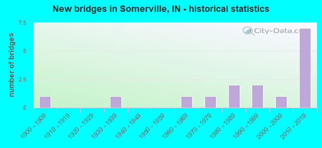
- New bridges - historical statistics
- 11900-1909
- 11930-1939
- 11960-1969
- 11970-1979
- 21980-1989
- 21990-1999
- 12000-2009
- 72010-2019

- Reconstructed bridges - Historical Statistics
- 11970-1979
- 11980-1989


- Bridge Condition - Deck
- 8.3%Very good
- 58.3%Good
- 25.0%Satisfactory
- 8.3%Fair

- Bridge Condition - Superstructure
- 33.3%Very good
- 25.0%Good
- 25.0%Satisfactory
- 8.3%Fair
- 8.3%Poor

- Bridge Condition - Substructure
- 16.7%Very good
- 33.3%Good
- 16.7%Satisfactory
- 33.3%Fair

- Bridge Condition - Channel
- 11.1%Very good
- 22.2%Good
- 33.3%Satisfactory
- 33.3%Fair

- Bridge Condition - Culverts
- 50.0%Good
- 50.0%Satisfactory
Find on map >> Show street view
Structure Number: 80108, Location: 01.49 S SR 64 (Lat: 38.304650, Lng: -87.396911), Route carried "on" structure: County highway , Year Built: 2012, Status: Open, Structure Length: 5.65m (18.54ft), Average Daily Traffic: 100 (year 2010), Truck Traffic: 5%, Average Future Daily Traffic: 160 (year 2030), Design Load: HL 93, Features Intersected: I-69 NB/SB, Facility Carried by Structure: CR 350S
Minimum Vertical Clearance: 30+ m (98+ ft), Kilometerpoint: 50.727, Lanes on structure: 2, Lanes under structure: 4, Owner: State Highway Agency, Approaching Roadway Width: 8.3m (27.2ft), Material/Design: Prestressed concrete continuous, Design/Construction: Tee Beam, Number Of Spans In Main Unit: 2, Length of Maximum Span: 28.0m (91.9ft), Curb-To-Curb Width: 8.3m (27.2ft), Out-to-Out Width: 9.2m (30.2ft)
Condition: Deck: Good, Superstructure: Very good, Substructure: Very good, Operating Rating: 52.5 metric tons, Method Used To Determine Operating Rating: Load and Resistance Factor Rating (LRFR) rating reported by rating factor(RF) method using HL-93 loadings, Inventory Rating: 32.4 metric tons, Method Used To Determine Inventory Rating: Load and Resistance Factor Rating (LRFR) rating reported by rating factor(RF) method using HL-93 loadings, Structural Evaluation: Equal to present desirable criteria, Deck Geometry: Equal to present minimum criteria, Underclear: Better than present minimum criteria, Approach Roadway Alignment: Equal to present desirable criteria, Designated Inspection Frequency: Every 24 months, Inspection Date: November 2020, Deck Structure Type: Concrete Cast-file-Place, Wearing Surface/Protective System: Wearing Surface: Monolithic Concrete, Deck Protection: Epoxy Coated Reinforcing
Find on map >> Show street view
Structure Number: 8011, Location: 01.25 S SR 64 (Lat: 38.308250, Lng: -87.396700), Route carried "on" structure: Interstate 69, Year Built: 2012, Status: Open, Structure Length: 3.09m (10.14ft), Average Daily Traffic: 9,487 (year 2008), Truck Traffic: 25%, Average Future Daily Traffic: 14,661 (year 2030), Design Load: HL 93, Features Intersected: UNT WEST FORK KEG CREEK
Minimum Vertical Clearance: 30+ m (98+ ft), Kilometerpoint: 51.113, Lanes on structure: 2, Base Highway Network: Yes (, Subroute: 1), Owner: State Highway Agency, Approaching Roadway Width: 12.3m (40.4ft), Material/Design: Prestressed concrete, Design/Construction: Tee Beam, Number Of Spans In Main Unit: 1, Length of Maximum Span: 30.5m (100.1ft), Curb-To-Curb Width: 12.3m (40.4ft), Out-to-Out Width: 13.2m (43.3ft)
Condition: Deck: Good, Superstructure: Very good, Substructure: Good, Channel: Good, Operating Rating: 61.2 metric tons, Method Used To Determine Operating Rating: Load and Resistance Factor Rating (LRFR) rating reported by rating factor(RF) method using HL-93 loadings, Inventory Rating: 36.6 metric tons, Method Used To Determine Inventory Rating: Load and Resistance Factor Rating (LRFR) rating reported by rating factor(RF) method using HL-93 loadings, Structural Evaluation: Better than present minimum criteria, Deck Geometry: Better than present minimum criteria, Waterway Adequacy: Superior to present desirable criteria, Approach Roadway Alignment: Equal to present desirable criteria, Designated Inspection Frequency: Every 24 months, Inspection Date: November 2020, Deck Structure Type: Concrete Cast-file-Place, Wearing Surface/Protective System: Wearing Surface: Monolithic Concrete, Deck Protection: Epoxy Coated Reinforcing
Find on map >> Show street view
Structure Number: 80112, Location: 01.25 S SR 64 (Lat: 38.308239, Lng: -87.397061), Route carried "on" structure: Interstate 69, Year Built: 2012, Status: Open, Structure Length: 3.09m (10.14ft), Average Daily Traffic: 9,487 (year 2008), Truck Traffic: 25%, Average Future Daily Traffic: 14,661 (year 2030), Design Load: HL 93, Features Intersected: UNT WEST FORK KEG CREEK
Minimum Vertical Clearance: 30+ m (98+ ft), Kilometerpoint: 51.113, Lanes on structure: 2, Base Highway Network: Yes (, Subroute: 1), Owner: State Highway Agency, Approaching Roadway Width: 12.3m (40.4ft), Material/Design: Prestressed concrete, Design/Construction: Tee Beam, Number Of Spans In Main Unit: 1, Length of Maximum Span: 30.5m (100.1ft), Curb-To-Curb Width: 12.3m (40.4ft), Out-to-Out Width: 13.2m (43.3ft)
Condition: Deck: Good, Superstructure: Very good, Substructure: Good, Channel: Very good, Operating Rating: 61.2 metric tons, Method Used To Determine Operating Rating: Load and Resistance Factor Rating (LRFR) rating reported by rating factor(RF) method using HL-93 loadings, Inventory Rating: 36.6 metric tons, Method Used To Determine Inventory Rating: Load and Resistance Factor Rating (LRFR) rating reported by rating factor(RF) method using HL-93 loadings, Structural Evaluation: Better than present minimum criteria, Deck Geometry: Better than present minimum criteria, Waterway Adequacy: Equal to present desirable criteria, Approach Roadway Alignment: Equal to present desirable criteria, Designated Inspection Frequency: Every 24 months, Inspection Date: November 2020, Deck Structure Type: Concrete Cast-file-Place, Wearing Surface/Protective System: Wearing Surface: Monolithic Concrete, Deck Protection: Epoxy Coated Reinforcing
Find on map >> Show street view
Structure Number: 80114, Location: 02.56 S SR 64 (Lat: 38.289889, Lng: -87.399700), Route carried "on" structure: Interstate 69, Year Built: 2012, Status: Open, Structure Length: 0.91m (2.99ft), Average Daily Traffic: 9,960 (year 2010), Truck Traffic: 25%, Average Future Daily Traffic: 14,760 (year 2030), Design Load: HL 93, Features Intersected: WILDLIFE UNDERCROSSING
Minimum Vertical Clearance: 30+ m (98+ ft), Kilometerpoint: 49.005, Lanes on structure: 2, Base Highway Network: Yes (, Subroute: 1), Owner: State Highway Agency, Approaching Roadway Width: 12.3m (40.4ft), Material/Design: Concrete, Design/Construction: Slab, Number Of Spans In Main Unit: 1, Length of Maximum Span: 8.8m (28.9ft), Curb-To-Curb Width: 12.3m (40.4ft), Out-to-Out Width: 13.2m (43.3ft)
Condition: Deck: Good, Superstructure: Good, Substructure: Very good, Operating Rating: 58.0 metric tons, Method Used To Determine Operating Rating: Load and Resistance Factor Rating (LRFR) rating reported by rating factor(RF) method using HL-93 loadings, Inventory Rating: 44.7 metric tons, Method Used To Determine Inventory Rating: Load and Resistance Factor Rating (LRFR) rating reported by rating factor(RF) method using HL-93 loadings, Structural Evaluation: Better than present minimum criteria, Deck Geometry: Better than present minimum criteria, Approach Roadway Alignment: Equal to present desirable criteria, Designated Inspection Frequency: Every 24 months, Inspection Date: November 2020, Deck Structure Type: Concrete Cast-file-Place, Wearing Surface/Protective System: Wearing Surface: Monolithic Concrete, Deck Protection: Epoxy Coated Reinforcing
Find on map >> Show street view
Structure Number: 80116, Location: 02.56 S SR 64 (Lat: 38.289939, Lng: -87.400000), Route carried "on" structure: Interstate 69, Year Built: 2012, Status: Open, Structure Length: 0.91m (2.99ft), Average Daily Traffic: 9,960 (year 2010), Truck Traffic: 25%, Average Future Daily Traffic: 14,760 (year 2030), Design Load: HL 93, Features Intersected: WILDLIFE UNDERCROSSING
Minimum Vertical Clearance: 30+ m (98+ ft), Kilometerpoint: 49.005, Lanes on structure: 2, Base Highway Network: Yes (, Subroute: 1), Owner: State Highway Agency, Approaching Roadway Width: 12.3m (40.4ft), Material/Design: Concrete, Design/Construction: Slab, Number Of Spans In Main Unit: 1, Length of Maximum Span: 8.8m (28.9ft), Curb-To-Curb Width: 12.3m (40.4ft), Out-to-Out Width: 13.2m (43.3ft)
Condition: Deck: Good, Superstructure: Good, Substructure: Good, Operating Rating: 58.0 metric tons, Method Used To Determine Operating Rating: Load and Resistance Factor Rating (LRFR) rating reported by rating factor(RF) method using HL-93 loadings, Inventory Rating: 44.7 metric tons, Method Used To Determine Inventory Rating: Load and Resistance Factor Rating (LRFR) rating reported by rating factor(RF) method using HL-93 loadings, Structural Evaluation: Better than present minimum criteria, Deck Geometry: Better than present minimum criteria, Approach Roadway Alignment: Equal to present desirable criteria, Designated Inspection Frequency: Every 24 months, Inspection Date: November 2020, Deck Structure Type: Concrete Cast-file-Place, Wearing Surface/Protective System: Wearing Surface: Monolithic Concrete, Deck Protection: Epoxy Coated Reinforcing
Find on map >> Show street view
Structure Number: 2600105, Location: 00.50 E OF CR 850 E (Lat: 38.311989, Lng: -87.398711), Route carried "on" structure: County highway , Year Built: 1995, Status: Posted for load, Structure Length: 1.23m (4.04ft), Average Daily Traffic: 5 (year 2012), Truck Traffic: 5%, Average Future Daily Traffic: 5 (year 2032), Design Load: HL 93, Features Intersected: WEST FORK OF KEG CREEK, Facility Carried by Structure: CR 300 S
Minimum Vertical Clearance: 30+ m (98+ ft), Kilometerpoint: 0.000, Lanes on structure: 2, Owner: County Highway Agency, Approaching Roadway Width: 5.5m (18.0ft), Material/Design: Aluminum, Iron, Design/Construction: Culvert, Number Of Spans In Main Unit: 1, Length of Maximum Span: 7.9m (25.9ft), Curb-To-Curb Width: 5.5m (18.0ft), Out-to-Out Width: 5.5m (18.0ft)
Condition: Channel: Satisfactory, Culverts: Good, Operating Rating: 33.0 metric tons, Method Used To Determine Operating Rating: Load and Resistance Factor (LRFR), Inventory Rating: 21.4 metric tons, Method Used To Determine Inventory Rating: Load and Resistance Factor (LRFR), Structural Evaluation: Equal to present minimum criteria, Deck Geometry: Meets minimum limits, Waterway Adequacy: Somewhat better than minimum adequacy, Approach Roadway Alignment: Equal to present desirable criteria, Designated Inspection Frequency: Every 24 months, Inspection Date: April 2020
Find on map >> Show street view
Structure Number: 2600106, Location: 00.80 E OF CR 850 E (Lat: 38.304611, Lng: -87.394203), Route carried "on" structure: County highway 72, Year Built: 1960, Status: Posted for load, Structure Length: 0.82m (2.69ft), Average Daily Traffic: 50 (year 2012), Truck Traffic: 1%, Average Future Daily Traffic: 55 (year 2032), Features Intersected: KELLEE BR W FORK KEG CR, Facility Carried by Structure: CR 350 S
Minimum Vertical Clearance: 30+ m (98+ ft), Kilometerpoint: 0.000, Lanes on structure: 2, Owner: County Highway Agency, Approaching Roadway Width: 5.5m (18.0ft), Material/Design: Steel, Design/Construction: Stringer/Multi-beam, Number Of Spans In Main Unit: 1, Length of Maximum Span: 7.5m (24.6ft), Curb-To-Curb Width: 6.6m (21.7ft), Out-to-Out Width: 6.7m (22.0ft)
Condition: Deck: Fair, Superstructure: Fair, Substructure: Fair, Channel: Fair, Operating Rating: 25.8 metric tons, Method Used To Determine Operating Rating: Load Factor (LF), Inventory Rating: 15.5 metric tons, Method Used To Determine Inventory Rating: Load Factor (LF), Structural Evaluation: Meets minimum limits, Deck Geometry: Somewhat better than minimum adequacy, Waterway Adequacy: Equal to present minimum criteria, Approach Roadway Alignment: Equal to present desirable criteria, Bridge Posting: Required (Relationship of Operating Rating to Maximum Legal Load: 20.0 - 29.9% below), Length Of Structure Improvement: 1.49m (4.89ft), Designated Inspection Frequency: Every 24 months, Inspection Date: March 2020, Bridge Improvement Cost: $201,000, Roadway Improvement Cost: $184,000, Total Project Cost: $486,000 ( Estimate for 2020), Deck Structure Type: Concrete Cast-file-Place, Wearing Surface/Protective System: Wearing Surface: Bituminous
Find on map >> Show street view
Structure Number: 2600107, Location: 00.20 W OF CR 950 E (Lat: 38.297389, Lng: -87.392478), Route carried "on" structure: County highway 268, Year Built: 1991, Status: Posted for load, Structure Length: 0.97m (3.18ft), Average Daily Traffic: 100 (year 2012), Truck Traffic: 5%, Average Future Daily Traffic: 125 (year 2032), Design Load: HS 20, Features Intersected: KELLEE BR W FORK KEG CR, Facility Carried by Structure: CR 400 S
Minimum Vertical Clearance: 30+ m (98+ ft), Kilometerpoint: 0.000, Lanes on structure: 1, Owner: County Highway Agency, Approaching Roadway Width: 4.9m (16.1ft), Material/Design: Aluminum, Iron, Design/Construction: Culvert, Number Of Spans In Main Unit: 1, Length of Maximum Span: 6.1m (20.0ft), Curb-To-Curb Width: 4.9m (16.1ft), Out-to-Out Width: 4.9m (16.1ft)
Condition: Channel: Satisfactory, Culverts: Satisfactory, Operating Rating: 31.8 metric tons, Method Used To Determine Operating Rating: Load and Resistance Factor (LRFR), Inventory Rating: 20.7 metric tons, Method Used To Determine Inventory Rating: Load and Resistance Factor (LRFR), Structural Evaluation: Equal to present minimum criteria, Deck Geometry: High priority of corrective action, Waterway Adequacy: Better than present minimum criteria, Approach Roadway Alignment: Equal to present desirable criteria, Bridge Posting: Required (Relationship of Operating Rating to Maximum Legal Load: 0.1 - 9.9% below), Designated Inspection Frequency: Every 24 months, Inspection Date: April 2020
Find on map >> Show street view
Structure Number: 2600123, Location: 00.10 N OF CR 350 S (Lat: 38.305169, Lng: -87.407914), Route carried "on" structure: County highway , Year Built: 1980, Status: Open, Structure Length: 1.26m (4.13ft), Average Daily Traffic: 100 (year 2012), Truck Traffic: 5%, Average Future Daily Traffic: 125 (year 2032), Features Intersected: WEST FORK OF KEG CREEK, Facility Carried by Structure: CR 850 E
Minimum Vertical Clearance: 30+ m (98+ ft), Kilometerpoint: 0.000, Lanes on structure: 2, Owner: County Highway Agency, Approaching Roadway Width: 6.4m (21.0ft), Skew: 4 degrees, Material/Design: Steel, Design/Construction: Stringer/Multi-beam, Number Of Spans In Main Unit: 1, Length of Maximum Span: 11.3m (37.1ft), Curb-To-Curb Width: 7.0m (23.0ft), Out-to-Out Width: 7.2m (23.6ft)
Condition: Deck: Good, Superstructure: Good, Substructure: Satisfactory, Channel: Fair, Operating Rating: 53.2 metric tons, Method Used To Determine Operating Rating: Load Factor (LF), Inventory Rating: 31.8 metric tons, Method Used To Determine Inventory Rating: Load Factor (LF), Structural Evaluation: Equal to present minimum criteria, Deck Geometry: Somewhat better than minimum adequacy, Waterway Adequacy: Somewhat better than minimum adequacy, Approach Roadway Alignment: Equal to present minimum criteria, Designated Inspection Frequency: Every 24 months, Inspection Date: April 2020, Deck Structure Type: Concrete Cast-file-Place, Wearing Surface/Protective System: Wearing Surface: Bituminous
Find on map >> Show street view
Structure Number: 2600124, Location: 00.10 W OF CR 850 E (Lat: 38.304850, Lng: -87.408278), Route carried "on" structure: County highway 72, Year Built: 1980, Status: Open, Structure Length: 1.13m (3.71ft), Average Daily Traffic: 100 (year 2012), Truck Traffic: 5%, Average Future Daily Traffic: 125 (year 2032), Features Intersected: WEST FORK OF KEG CREEK, Facility Carried by Structure: CR 350 S
Minimum Vertical Clearance: 30+ m (98+ ft), Kilometerpoint: 0.000, Lanes on structure: 2, Owner: County Highway Agency, Approaching Roadway Width: 4.9m (16.1ft), Skew: 4 degrees, Material/Design: Steel, Design/Construction: Stringer/Multi-beam, Number Of Spans In Main Unit: 1, Length of Maximum Span: 9.8m (32.2ft), Curb-To-Curb Width: 6.6m (21.7ft), Out-to-Out Width: 6.7m (22.0ft)
Condition: Deck: Satisfactory, Superstructure: Satisfactory, Substructure: Fair, Channel: Fair, Operating Rating: 55.4 metric tons, Method Used To Determine Operating Rating: Load Factor (LF), Inventory Rating: 33.2 metric tons, Method Used To Determine Inventory Rating: Load Factor (LF), Structural Evaluation: Somewhat better than minimum adequacy, Deck Geometry: Somewhat better than minimum adequacy, Waterway Adequacy: Somewhat better than minimum adequacy, Approach Roadway Alignment: High priority of corrective action, Designated Inspection Frequency: Every 24 months, Inspection Date: March 2020, Deck Structure Type: Concrete Cast-file-Place, Wearing Surface/Protective System: Wearing Surface: Gravel
Find on map >> Show street view
Structure Number: 2600222, Location: 00.30 N OF CR 600 S (Lat: 38.271950, Lng: -87.377778), Route carried "on" structure: County highway , Year Built: 1900, Year Reconstructed: 1970, Status: Open, Structure Length: 0.73m (2.40ft), Average Daily Traffic: 250 (year 2012), Truck Traffic: 4%, Average Future Daily Traffic: 300 (year 2032), Features Intersected: DONOHUE CREEK, Facility Carried by Structure: CR 1025 E
Minimum Vertical Clearance: 30+ m (98+ ft), Kilometerpoint: 0.000, Lanes on structure: 2, Owner: County Highway Agency, Approaching Roadway Width: 5.8m (19.0ft), Material/Design: Steel, Design/Construction: Stringer/Multi-beam, Number Of Spans In Main Unit: 1, Length of Maximum Span: 6.2m (20.3ft), Curb-To-Curb Width: 6.6m (21.7ft), Out-to-Out Width: 6.7m (22.0ft)
Condition: Deck: Satisfactory, Superstructure: Satisfactory, Substructure: Satisfactory, Channel: Satisfactory, Operating Rating: 64.5 metric tons, Method Used To Determine Operating Rating: Load Factor (LF), Inventory Rating: 38.6 metric tons, Method Used To Determine Inventory Rating: Load Factor (LF), Structural Evaluation: Equal to present minimum criteria, Deck Geometry: Meets minimum limits, Waterway Adequacy: Better than present minimum criteria, Approach Roadway Alignment: Equal to present desirable criteria, Designated Inspection Frequency: Every 24 months, Inspection Date: March 2020, Deck Structure Type: Concrete Cast-file-Place, Wearing Surface/Protective System: Wearing Surface: Bituminous
Find on map >> Show street view
Structure Number: 2600272, Location: 00.20 E OF SR 57 (Lat: 38.289739, Lng: -87.373436), Route carried "on" structure: County highway 76, Year Built: 1930, Year Reconstructed: 1985, Status: Posted for load, Structure Length: 4.27m (14.01ft), Average Daily Traffic: 305 (year 2013), Truck Traffic: 14%, Average Future Daily Traffic: 420 (year 2033), Design Load: HS 20, Features Intersected: BIG FOUR RR, Facility Carried by Structure: CR 450 S
Minimum Vertical Clearance: 30+ m (98+ ft), Kilometerpoint: 0.000, Lanes on structure: 2, Owner: County Highway Agency, Approaching Roadway Width: 6.1m (20.0ft), Skew: 1 degrees, Material/Design: Wood or Timber, Design/Construction: Stringer/Multi-beam, Number Of Spans In Main Unit: 6, Length of Maximum Span: 7.0m (23.0ft), Curb or Sidewalk Widths: Left: 0.2m (0.7ft), Right: 0.2m (0.7ft), Curb-To-Curb Width: 6.6m (21.7ft), Out-to-Out Width: 7.0m (23.0ft)
Condition: Deck: Good, Superstructure: Satisfactory, Substructure: Fair, Operating Rating: 23.9 metric tons, Method Used To Determine Operating Rating: Field evaluation and documented engineering judgment, Inventory Rating: 20.4 metric tons, Method Used To Determine Inventory Rating: Field evaluation and documented engineering judgment, Structural Evaluation: Somewhat better than minimum adequacy, Deck Geometry: Meets minimum limits, Underclear: High priority of corrective action, Approach Roadway Alignment: Equal to present minimum criteria, Bridge Posting: Required (Relationship of Operating Rating to Maximum Legal Load: 20.0 - 29.9% below), Designated Inspection Frequency: Every 24 months, Inspection Date: March 2020, Deck Structure Type: Wood or Timber, Wearing Surface/Protective System: Wearing Surface: Wood or Timber
Find on map >> Show street view
Structure Number: 2600327, Location: 00.50 N OF CR 700 S (Lat: 38.262169, Lng: -87.377831), Route carried "on" structure: County highway , Year Built: 2001, Status: Open, Structure Length: 1.66m (5.45ft), Average Daily Traffic: 250 (year 2012), Truck Traffic: 10%, Average Future Daily Traffic: 300 (year 2032), Design Load: HS 20, Features Intersected: RAILROAD, Facility Carried by Structure: CR 1025 E
Minimum Vertical Clearance: 30+ m (98+ ft), Kilometerpoint: 0.000, Lanes on structure: 2, Owner: County Highway Agency, Approaching Roadway Width: 6.1m (20.0ft), Material/Design: Prestressed concrete, Design/Construction: Box Beam or Girders - Multiple, Number Of Spans In Main Unit: 1, Length of Maximum Span: 15.7m (51.5ft), Curb-To-Curb Width: 7.3m (24.0ft), Out-to-Out Width: 7.4m (24.3ft)
Condition: Deck: Very good, Superstructure: Very good, Substructure: Good, Operating Rating: 32.7 metric tons, Method Used To Determine Operating Rating: Field evaluation and documented engineering judgment, Inventory Rating: 32.7 metric tons, Method Used To Determine Inventory Rating: Field evaluation and documented engineering judgment, Structural Evaluation: Better than present minimum criteria, Deck Geometry: Somewhat better than minimum adequacy, Underclear: Equal to present desirable criteria, Approach Roadway Alignment: Equal to present desirable criteria, Designated Inspection Frequency: Every 24 months, Inspection Date: March 2020, Deck Structure Type: Concrete Precast Panels, Wearing Surface/Protective System: Wearing Surface: Bituminous
Find on map >> Show street view
Structure Number: 2600359, Location: 00.20 E OF CR 1025 E (Lat: 38.267103, Lng: -87.374750), Route carried "on" structure: County highway , Year Built: 1970, Status: Posted for load, Structure Length: 0.91m (2.99ft), Average Daily Traffic: 148 (year 2016), Truck Traffic: 5%, Average Future Daily Traffic: 210 (year 2036), Features Intersected: DONOHUE CREEK, Facility Carried by Structure: CR 600 S
Minimum Vertical Clearance: 30+ m (98+ ft), Kilometerpoint: 0.000, Lanes on structure: 1, Owner: County Highway Agency, Approaching Roadway Width: 4.9m (16.1ft), Material/Design: Prestressed concrete, Design/Construction: Box Beam or Girders - Multiple, Number Of Spans In Main Unit: 1, Length of Maximum Span: 7.9m (25.9ft), Curb-To-Curb Width: 4.6m (15.1ft), Out-to-Out Width: 4.6m (15.1ft)
Condition: Deck: Satisfactory, Superstructure: Poor, Substructure: Fair, Channel: Good, Operating Rating: 32.8 metric tons, Method Used To Determine Operating Rating: Load and Resistance Factor (LRFR), Inventory Rating: 24.3 metric tons, Method Used To Determine Inventory Rating: Load and Resistance Factor (LRFR), Structural Evaluation: Meets minimum limits, Deck Geometry: High priority of replacement, Waterway Adequacy: Equal to present desirable criteria, Approach Roadway Alignment: Equal to present desirable criteria, Length Of Structure Improvement: 0.91m (2.99ft), Designated Inspection Frequency: Every 12 months, Inspection Date: March 2021, Bridge Improvement Cost: $69,000, Roadway Improvement Cost: $184,000, Total Project Cost: $307,000 ( Estimate for 2020), Deck Structure Type: Concrete Precast Panels, Wearing Surface/Protective System: Wearing Surface: Monolithic Concrete
Find on map >> Show street view
Structure Number: 80108, Location: 01.48 N SR 168 (Lat: 38.304650, Lng: -87.396911), Route carried "under" structure: Interstate 69, Year Built: 2012, Structure Length: 0. m, Average Daily Traffic: 9,960 (year 2010), Truck Traffic: 25%, Features Intersected: I-69 SBL, Facility Carried by Structure: CR 350S
Minimum Vertical Clearance: 5.87m (19.26ft), Kilometerpoint: 50.727, Lanes on structure: 2, Lanes under structure: 4, Material/Design: Prestressed concrete continuous, Design/Construction: Tee Beam, Length of Maximum Span: 28.0m (91.9ft)
Find on map >> Show street view
Structure Number: 80108, Location: 01.48 N SR 168 (Lat: 38.304650, Lng: -87.396911), Route carried "under" structure: Interstate 69, Year Built: 2012, Structure Length: 0. m, Average Daily Traffic: 9,960 (year 2010), Truck Traffic: 25%, Features Intersected: I-69 NBL, Facility Carried by Structure: CR 350S
Minimum Vertical Clearance: 5.21m (17.09ft), Kilometerpoint: 50.727, Lanes on structure: 2, Lanes under structure: 4, Material/Design: Prestressed concrete continuous, Design/Construction: Tee Beam, Length of Maximum Span: 28.0m (91.9ft)