Bridge Statistics for Sonora, California (CA)
Condition, Traffic, Stress, Structural Evaluation, Project Costs
- National Bridge Inventory (NBI) Statistics
- 19Number of bridges
- 167ft / 51.4mTotal length
- 163,403Total average daily traffic
- 8,996Total average daily truck traffic
- National Bridge Inventory (NBI) Registered Bridges for Sonora
- No street view available for this location
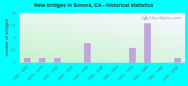
- New bridges - historical statistics
- 11900-1909
- 11910-1919
- 11920-1929
- 41940-1949
- 31970-1979
- 81980-1989
- 12000-2009

- Reconstructed bridges - Historical Statistics
- 11940-1949
- 01950-1959
- 11960-1969
- 11970-1979
- 11980-1989
- 11990-1999
- 12000-2009


- Bridge Condition - Deck
- 60.0%Good
- 13.3%Satisfactory
- 26.7%Fair

- Bridge Condition - Superstructure
- 86.7%Good
- 13.3%Fair

- Bridge Condition - Substructure
- 80.0%Good
- 6.7%Satisfactory
- 13.3%Fair

- Bridge Condition - Channel
- 20.0%Excellent
- 10.0%Very good
- 20.0%Good
- 20.0%Satisfactory
- 30.0%Fair
Find on map >> Show street view
Structure Number: 32 0004, Location: 10-TUO-049-13.52 (Lat: 37.941064, Lng: -120.432664), Route carried "on" structure: State highway 49, Year Built: 1941, Status: Open, Structure Length: 3.96m (12.99ft), Average Daily Traffic: 19,900 (year 2009), Average Future Daily Traffic: 19,254 (year 2039), Design Load: H 20, Features Intersected: WOODS CREEK
Minimum Vertical Clearance: 30+ m (98+ ft), Kilometerpoint: 13.520, Lanes on structure: 2, Owner: State Highway Agency, Approaching Roadway Width: 9.1m (29.9ft), Skew: 3 degrees, Material/Design: Concrete continuous, Design/Construction: Tee Beam, Number Of Spans In Main Unit: 3, Length of Maximum Span: 15.2m (49.9ft), Curb or Sidewalk Widths: Left: 0.4m (1.3ft), Right: 0.4m (1.3ft), Curb-To-Curb Width: 7.9m (25.9ft), Out-to-Out Width: 8.9m (29.2ft)
Condition: Deck: Good, Superstructure: Good, Substructure: Good, Channel: Excellent, Operating Rating: 33.4 metric tons, Method Used To Determine Operating Rating: Load and Resistance Factor Rating (LRFR) rating reported by rating factor(RF) method using HL-93 loadings, Inventory Rating: 25.9 metric tons, Method Used To Determine Inventory Rating: Load and Resistance Factor Rating (LRFR) rating reported by rating factor(RF) method using HL-93 loadings, Structural Evaluation: Equal to present minimum criteria, Deck Geometry: High priority of replacement, Waterway Adequacy: Equal to present desirable criteria, Approach Roadway Alignment: Superior to present desirable criteria, Designated Inspection Frequency: Every 24 months, Inspection Date: September 2021, Deck Structure Type: Concrete Cast-file-Place, Wearing Surface/Protective System: Wearing Surface: Monolithic Concrete
Find on map >> Show street view
Structure Number: 32 0006, Location: 10-TUO-049-17.49-SRA (Lat: 37.979772, Lng: -120.389103), Route carried "on" structure: State highway 49, Year Built: 1902, Year Reconstructed: 1951, Status: Open, Structure Length: 0.79m (2.59ft), Average Daily Traffic: 11,500 (year 2009), Truck Traffic: 7%, Average Future Daily Traffic: 12,153 (year 2041), Design Load: H 20, Features Intersected: WOODS CREEK
Minimum Vertical Clearance: 30+ m (98+ ft), Kilometerpoint: 17.490, Lanes on structure: 2, Base Highway Network: Yes (, Subroute: 1), Owner: State Highway Agency, Approaching Roadway Width: 11.3m (37.1ft), Skew: 9 degrees, Material/Design: Steel, Design/Construction: Stringer/Multi-beam, Number Of Spans In Main Unit: 1, Length of Maximum Span: 7.3m (24.0ft), Curb or Sidewalk Widths: Left: 0.4m (1.3ft), Right: 0.2m (0.7ft), Curb-To-Curb Width: 11.5m (37.7ft), Out-to-Out Width: 12.1m (39.7ft)
Condition: Deck: Fair, Superstructure: Good, Substructure: Satisfactory, Channel: Good, Operating Rating: 39.5 metric tons, Method Used To Determine Operating Rating: Load Factor (LF), Inventory Rating: 23.7 metric tons, Method Used To Determine Inventory Rating: Load Factor (LF), Structural Evaluation: Somewhat better than minimum adequacy, Deck Geometry: Meets minimum limits, Waterway Adequacy: Better than present minimum criteria, Approach Roadway Alignment: Equal to present desirable criteria, Designated Inspection Frequency: Every 24 months, Inspection Date: September 2021, Deck Structure Type: Concrete Cast-file-Place, Wearing Surface/Protective System: Wearing Surface: Bituminous
Find on map >> Show street view
Structure Number: 32 0007, Location: 10-TUO-049-17.80-SRA (Lat: 37.982639, Lng: -120.385331), Route carried "on" structure: State highway 49, Year Built: 1947, Status: Open, Structure Length: 1.13m (3.71ft), Average Daily Traffic: 11,500 (year 2009), Truck Traffic: 7%, Average Future Daily Traffic: 12,564 (year 2043), Design Load: HS 20, Features Intersected: SONORA CREEK
Minimum Vertical Clearance: 30+ m (98+ ft), Kilometerpoint: 17.800, Lanes on structure: 2, Base Highway Network: Yes (, Subroute: 1), Owner: State Highway Agency, Approaching Roadway Width: 13.0m (42.7ft), Skew: 5 degrees, Material/Design: Concrete, Design/Construction: Slab, Number Of Spans In Main Unit: 1, Length of Maximum Span: 10.1m (33.1ft), Curb or Sidewalk Widths: Left: 1.2m (3.9ft), Right: 1.2m (3.9ft), Curb-To-Curb Width: 7.9m (25.9ft), Out-to-Out Width: 11.0m (36.1ft)
Condition: Deck: Good, Superstructure: Good, Substructure: Good, Channel: Very good, Operating Rating: 82.6 metric tons, Method Used To Determine Operating Rating: Load Factor (LF), Inventory Rating: 49.6 metric tons, Method Used To Determine Inventory Rating: Load Factor (LF), Structural Evaluation: Better than present minimum criteria, Deck Geometry: High priority of replacement, Waterway Adequacy: Equal to present desirable criteria, Approach Roadway Alignment: Equal to present desirable criteria, Designated Inspection Frequency: Every 48 months, Inspection Date: September 2021, Deck Structure Type: Concrete Cast-file-Place, Wearing Surface/Protective System: Wearing Surface: Bituminous
Find on map >> Show street view
Structure Number: 32 0055, Location: 10-TUO-120-R44.84 (Lat: 37.821625, Lng: -120.036578), Route carried "on" structure: State highway 120, Year Built: 1970, Year Reconstructed: 2013, Status: Open, Structure Length: 13.00m (42.65ft), Average Daily Traffic: 3,650 (year 2009), Average Future Daily Traffic: 3,123 (year 2039), Design Load: HS 20, Features Intersected: HILLSIDE
Minimum Vertical Clearance: 30+ m (98+ ft), Kilometerpoint: 44.840, Lanes on structure: 2, Base Highway Network: Yes (Inventory Route: 1, Subroute: 2), Owner: State Highway Agency, Approaching Roadway Width: 9.1m (29.9ft), Material/Design: Prestressed concrete continuous, Design/Construction: Stringer/Multi-beam, Number Of Spans In Main Unit: 4, Length of Maximum Span: 32.7m (107.3ft), Curb-To-Curb Width: 9.8m (32.2ft), Out-to-Out Width: 10.6m (34.8ft)
Condition: Deck: Good, Superstructure: Good, Substructure: Good, Operating Rating: 82.5 metric tons, Method Used To Determine Operating Rating: Load Factor (LF), Inventory Rating: 32.6 metric tons, Method Used To Determine Inventory Rating: Load Factor (LF), Structural Evaluation: Better than present minimum criteria, Deck Geometry: Meets minimum limits, Approach Roadway Alignment: Equal to present desirable criteria, Designated Inspection Frequency: Every 24 months, Inspection Date: September 2021, Deck Structure Type: Concrete Cast-file-Place, Wearing Surface/Protective System: Wearing Surface: Integral Concrete
Find on map >> Show street view
Structure Number: 32 0059, Location: 10-TUO-108-R0.03-SRA (Lat: 37.965200, Lng: -120.393422), Route carried "on" structure: State highway 108, Year Built: 1987, Status: Open, Structure Length: 7.71m (25.30ft), Average Daily Traffic: 17,450 (year 2009), Truck Traffic: 8%, Average Future Daily Traffic: 33,407 (year 2039), Design Load: HS 20+Mod, Features Intersected: SR 49 NB & WOODS CREEK
Minimum Vertical Clearance: 30+ m (98+ ft), Kilometerpoint: 0.030, Lanes on structure: 2, Lanes under structure: 1, Base Highway Network: Yes (Inventory Route: 1, Subroute: 1), Owner: State Highway Agency, Approaching Roadway Width: 12.2m (40.0ft), Material/Design: Prestressed concrete continuous, Design/Construction: Box Beam or Girders - Multiple, Number Of Spans In Main Unit: 3, Length of Maximum Span: 32.0m (105.0ft), Curb-To-Curb Width: 12.2m (40.0ft), Out-to-Out Width: 13.3m (43.6ft)
Condition: Deck: Good, Superstructure: Good, Substructure: Good, Channel: Excellent, Operating Rating: 54.1 metric tons, Method Used To Determine Operating Rating: Assigned rating based on Load Factor Design (LFD) reported in metric tons, Inventory Rating: 32.4 metric tons, Method Used To Determine Inventory Rating: Assigned rating based on Load Factor Design (LFD) reported in metric tons, Structural Evaluation: Better than present minimum criteria, Deck Geometry: Somewhat better than minimum adequacy, Underclear: Equal to present minimum criteria, Waterway Adequacy: Equal to present desirable criteria, Approach Roadway Alignment: Equal to present minimum criteria, Designated Inspection Frequency: Every 24 months, Inspection Date: September 2021, Deck Structure Type: Concrete Cast-file-Place, Wearing Surface/Protective System: Wearing Surface: Integral Concrete
Find on map >> Show street view
Structure Number: 32 0062, Location: 10-TUO-108-R2.02-SRA (Lat: 37.973997, Lng: -120.360350), Route carried "on" structure: State highway 108, Year Built: 1987, Year Reconstructed: 2003, Status: Open, Structure Length: 5.06m (16.60ft), Average Daily Traffic: 17,450 (year 2009), Truck Traffic: 8%, Average Future Daily Traffic: 33,407 (year 2039), Design Load: HS 20+Mod, Features Intersected: SERA & SANGUINETTI RD
Minimum Vertical Clearance: 30+ m (98+ ft), Kilometerpoint: 2.020, Lanes on structure: 3, Lanes under structure: 2, Base Highway Network: Yes (Inventory Route: 1, Subroute: 1), Owner: State Highway Agency, Approaching Roadway Width: 19.9m (65.3ft), Material/Design: Concrete continuous, Design/Construction: Box Beam or Girders - Multiple, Number Of Spans In Main Unit: 2, Length of Maximum Span: 29.6m (97.1ft), Curb-To-Curb Width: 19.9m (65.3ft), Out-to-Out Width: 21.0m (68.9ft)
Condition: Deck: Fair, Superstructure: Good, Substructure: Good, Operating Rating: 54.1 metric tons, Method Used To Determine Operating Rating: Assigned rating based on Load Factor Design (LFD) reported in metric tons, Inventory Rating: 32.4 metric tons, Method Used To Determine Inventory Rating: Assigned rating based on Load Factor Design (LFD) reported in metric tons, Structural Evaluation: Better than present minimum criteria, Deck Geometry: Superior to present desirable criteria, Underclear: Somewhat better than minimum adequacy, Approach Roadway Alignment: Equal to present desirable criteria, Designated Inspection Frequency: Every 24 months, Inspection Date: September 2021, Deck Structure Type: Concrete Cast-file-Place
Find on map >> Show street view
Structure Number: 32 0062S, Location: 10-TUO-108-R2.02-SRA (Lat: 37.973997, Lng: -120.360186), Route carried "on" structure: Ramp State highway 108, Year Built: 2004, Status: Open, Structure Length: 5.17m (16.96ft), Average Daily Traffic: 2,500 (year 2004), Truck Traffic: 1%, Average Future Daily Traffic: 3,753 (year 2041), Design Load: HS 20+Mod, Features Intersected: SIERRA RR SANGUINETTI RD
Minimum Vertical Clearance: 30+ m (98+ ft), Kilometerpoint: 2.020, Lanes on structure: 1, Lanes under structure: 2, Base Highway Network: Yes (, Subroute: 1), Owner: State Highway Agency, Approaching Roadway Width: 7.2m (23.6ft), Material/Design: Prestressed concrete continuous, Design/Construction: Box Beam or Girders - Multiple, Number Of Spans In Main Unit: 2, Length of Maximum Span: 30.0m (98.4ft), Curb-To-Curb Width: 7.2m (23.6ft), Out-to-Out Width: 8.3m (27.2ft)
Condition: Deck: Fair, Superstructure: Good, Substructure: Good, Operating Rating: 54.1 metric tons, Method Used To Determine Operating Rating: Assigned rating based on Load Factor Design (LFD) reported in metric tons, Inventory Rating: 32.4 metric tons, Method Used To Determine Inventory Rating: Assigned rating based on Load Factor Design (LFD) reported in metric tons, Structural Evaluation: Better than present minimum criteria, Deck Geometry: Equal to present minimum criteria, Underclear: Somewhat better than minimum adequacy, Approach Roadway Alignment: Equal to present desirable criteria, Designated Inspection Frequency: Every 24 months, Inspection Date: September 2021, Deck Structure Type: Concrete Cast-file-Place
Find on map >> Show street view
Structure Number: 32 0063, Location: 10-TUO-108-R1.57-SRA (Lat: 37.970731, Lng: -120.367150), Route carried "on" structure: City street , Year Built: 1987, Status: Open, Structure Length: 3.35m (10.99ft), Average Daily Traffic: 102 (year 2001), Truck Traffic: 5%, Average Future Daily Traffic: 163 (year 2039), Design Load: HS 20, Features Intersected: STATE ROUTE 108, Facility Carried by Structure: OLD WARDS FERRY RD
Minimum Vertical Clearance: 30+ m (98+ ft), Kilometerpoint: 0.000, Lanes on structure: 2, Lanes under structure: 3, Owner: State Highway Agency, Approaching Roadway Width: 12.2m (40.0ft), Material/Design: Prestressed concrete, Design/Construction: Box Beam or Girders - Multiple, Number Of Spans In Main Unit: 1, Length of Maximum Span: 33.5m (109.9ft), Curb-To-Curb Width: 12.2m (40.0ft), Out-to-Out Width: 13.3m (43.6ft)
Condition: Deck: Satisfactory, Superstructure: Good, Substructure: Good, Operating Rating: 54.1 metric tons, Method Used To Determine Operating Rating: Assigned rating based on Load Factor Design (LFD) reported in metric tons, Inventory Rating: 32.4 metric tons, Method Used To Determine Inventory Rating: Assigned rating based on Load Factor Design (LFD) reported in metric tons, Structural Evaluation: Better than present minimum criteria, Deck Geometry: Superior to present desirable criteria, Underclear: Meets minimum limits, Approach Roadway Alignment: Equal to present desirable criteria, Designated Inspection Frequency: Every 24 months, Inspection Date: September 2021, Deck Structure Type: Concrete Cast-file-Place
Find on map >> Show street view
Structure Number: 32 0064, Location: 10-TUO-108-R0.65-SRA (Lat: 37.965639, Lng: -120.382386), Route carried "on" structure: City street , Year Built: 1987, Status: Open, Structure Length: 3.69m (12.11ft), Average Daily Traffic: 1,000 (year 1998), Truck Traffic: 5%, Average Future Daily Traffic: 3,218 (year 2041), Design Load: HS 20, Features Intersected: STATE ROUTE 108, Facility Carried by Structure: CROOKED LANE
Minimum Vertical Clearance: 30+ m (98+ ft), Kilometerpoint: 0.650, Lanes on structure: 2, Lanes under structure: 3, Owner: State Highway Agency, Approaching Roadway Width: 8.5m (27.9ft), Material/Design: Prestressed concrete, Design/Construction: Box Beam or Girders - Multiple, Number Of Spans In Main Unit: 1, Length of Maximum Span: 36.9m (121.1ft), Curb-To-Curb Width: 8.5m (27.9ft), Out-to-Out Width: 9.6m (31.5ft)
Condition: Deck: Satisfactory, Superstructure: Good, Substructure: Good, Operating Rating: 54.1 metric tons, Method Used To Determine Operating Rating: Assigned rating based on Load Factor Design (LFD) reported in metric tons, Inventory Rating: 32.4 metric tons, Method Used To Determine Inventory Rating: Assigned rating based on Load Factor Design (LFD) reported in metric tons, Structural Evaluation: Better than present minimum criteria, Deck Geometry: Somewhat better than minimum adequacy, Underclear: Equal to present minimum criteria, Approach Roadway Alignment: Equal to present desirable criteria, Designated Inspection Frequency: Every 24 months, Inspection Date: September 2021, Deck Structure Type: Concrete Cast-file-Place
Find on map >> Show street view
Structure Number: 32C0011, Location: 0.9 MI S OF CAMPO SECO RD (Lat: 37.956453, Lng: -120.368722), Route carried "on" structure: County highway , Year Built: 1945, Year Reconstructed: 1973, Status: Open, Structure Length: 2.19m (7.19ft), Average Daily Traffic: 1,800 (year 2014), Truck Traffic: 2%, Average Future Daily Traffic: 2,202 (year 2043), Design Load: HS 20, Features Intersected: SULLIVAN CREEK, Facility Carried by Structure: LIME KILN RD
Minimum Vertical Clearance: 30+ m (98+ ft), Kilometerpoint: 0.000, Lanes on structure: 2, Owner: County Highway Agency, Approaching Roadway Width: 6.7m (22.0ft), Material/Design: Concrete continuous, Design/Construction: Slab, Number Of Spans In Main Unit: 4, Length of Maximum Span: 5.5m (18.0ft), Curb-To-Curb Width: 7.1m (23.3ft), Out-to-Out Width: 7.3m (24.0ft)
Condition: Deck: Good, Superstructure: Good, Substructure: Good, Channel: Good, Operating Rating: 99.8 metric tons, Method Used To Determine Operating Rating: Load Factor (LF), Inventory Rating: 71.0 metric tons, Method Used To Determine Inventory Rating: Load Factor (LF), Structural Evaluation: Better than present minimum criteria, Deck Geometry: High priority of corrective action, Waterway Adequacy: Better than present minimum criteria, Approach Roadway Alignment: High priority of corrective action, Designated Inspection Frequency: Every 48 months, Inspection Date: July 2021, Deck Structure Type: Concrete Cast-file-Place
Find on map >> Show street view
Structure Number: 32C0015, Location: 100' NORTH OF THEALL (Lat: 37.984497, Lng: -120.380753), Route carried "on" structure: City street , Year Built: 1920, Year Reconstructed: 1983, Status: Open, Structure Length: 0.76m (2.49ft), Average Daily Traffic: 2,000 (year 2009), Truck Traffic: 2%, Average Future Daily Traffic: 5,414 (year 2042), Features Intersected: SONORA CREEK, Facility Carried by Structure: SOUTH BARRETTA ST
Minimum Vertical Clearance: 30+ m (98+ ft), Kilometerpoint: 0.000, Lanes on structure: 2, Owner: City or Municipal Highway Agency, Approaching Roadway Width: 6.1m (20.0ft), Skew: 1 degrees, Material/Design: Steel, Design/Construction: Slab, Number Of Spans In Main Unit: 1, Length of Maximum Span: 7.3m (24.0ft), Curb or Sidewalk Widths: Left: 0.3m (1.0ft), Right: 0.3m (1.0ft), Curb-To-Curb Width: 7.2m (23.6ft), Out-to-Out Width: 7.8m (25.6ft)
Condition: Deck: Good, Superstructure: Fair, Substructure: Good, Channel: Fair, Operating Rating: 34.7 metric tons, Method Used To Determine Operating Rating: Allowable Stress (AS), Inventory Rating: 18.1 metric tons, Method Used To Determine Inventory Rating: Allowable Stress (AS), Structural Evaluation: Somewhat better than minimum adequacy, Deck Geometry: High priority of corrective action, Waterway Adequacy: Equal to present minimum criteria, Approach Roadway Alignment: Better than present minimum criteria, Designated Inspection Frequency: Every 24 months, Inspection Date: May 2020, Deck Structure Type: Concrete Cast-file-Place, Wearing Surface/Protective System: Wearing Surface: Bituminous
Find on map >> Show street view
Structure Number: 32C0018, Location: 0.8 MI S HWY 108 (Lat: 37.963428, Lng: -120.361308), Route carried "on" structure: County highway , Year Built: 1977, Status: Open, Structure Length: 2.16m (7.09ft), Average Daily Traffic: 810 (year 2017), Truck Traffic: 4%, Average Future Daily Traffic: 1,091 (year 2041), Design Load: HS 20, Features Intersected: SULLIVAN CREEK, Facility Carried by Structure: OLD WARDS FERRY RD
Minimum Vertical Clearance: 30+ m (98+ ft), Kilometerpoint: 0.000, Lanes on structure: 2, Owner: County Highway Agency, Approaching Roadway Width: 4.6m (15.1ft), Material/Design: Concrete, Design/Construction: Box Beam or Girders - Multiple, Number Of Spans In Main Unit: 1, Length of Maximum Span: 21.3m (69.9ft), Curb-To-Curb Width: 8.6m (28.2ft), Out-to-Out Width: 8.7m (28.5ft)
Condition: Deck: Good, Superstructure: Good, Substructure: Good, Channel: Fair, Operating Rating: 58.6 metric tons, Method Used To Determine Operating Rating: Load and Resistance Factor Rating (LRFR) rating reported by rating factor(RF) method using HL-93 loadings, Inventory Rating: 45.4 metric tons, Method Used To Determine Inventory Rating: Load and Resistance Factor Rating (LRFR) rating reported by rating factor(RF) method using HL-93 loadings, Structural Evaluation: Better than present minimum criteria, Deck Geometry: Somewhat better than minimum adequacy, Waterway Adequacy: Better than present minimum criteria, Approach Roadway Alignment: Equal to present desirable criteria, Designated Inspection Frequency: Every 24 months, Inspection Date: July 2021, Deck Structure Type: Concrete Cast-file-Place
Find on map >> Show street view
Structure Number: 32C0039, Location: 0.3 MI N OF SR 49 (Lat: 37.993564, Lng: -120.382100), Route carried "on" structure: County highway , Year Built: 1912, Year Reconstructed: 1980, Status: Open, Structure Length: 0.73m (2.40ft), Average Daily Traffic: 375 (year 2009), Truck Traffic: 1%, Average Future Daily Traffic: 544 (year 2040), Features Intersected: WOODS CREEK, Facility Carried by Structure: COLUMBIA WAY
Minimum Vertical Clearance: 30+ m (98+ ft), Kilometerpoint: 0.000, Lanes on structure: 2, Owner: County Highway Agency, Approaching Roadway Width: 5.5m (18.0ft), Skew: 3 degrees, Material/Design: Concrete, Design/Construction: Slab, Number Of Spans In Main Unit: 1, Length of Maximum Span: 6.1m (20.0ft), Curb-To-Curb Width: 5.5m (18.0ft), Out-to-Out Width: 6.5m (21.3ft)
Condition: Deck: Good, Superstructure: Good, Substructure: Good, Channel: Fair, Operating Rating: 32.4 metric tons, Method Used To Determine Operating Rating: Load Factor (LF), Inventory Rating: 19.4 metric tons, Method Used To Determine Inventory Rating: Load Factor (LF), Structural Evaluation: Somewhat better than minimum adequacy, Deck Geometry: High priority of corrective action, Waterway Adequacy: Equal to present minimum criteria, Approach Roadway Alignment: Meets minimum limits, Designated Inspection Frequency: Every 24 months, Inspection Date: May 2020, Deck Structure Type: Concrete Cast-file-Place, Wearing Surface/Protective System: Wearing Surface: Bituminous
Find on map >> Show street view
Structure Number: 32C007, Location: 2.0 MI N OF LANGEWAY RD (Lat: 38.025406, Lng: -120.270131), Route carried "on" structure: County highway , Year Built: 1970, Status: Open, Structure Length: 0.73m (2.40ft), Average Daily Traffic: 3,266 (year 2011), Truck Traffic: 2%, Average Future Daily Traffic: 4,420 (year 2040), Features Intersected: SULLIVAN CREEK, Facility Carried by Structure: CRYSTAL FALLS DR
Minimum Vertical Clearance: 30+ m (98+ ft), Kilometerpoint: 0.000, Lanes on structure: 2, Owner: County Highway Agency, Approaching Roadway Width: 6.7m (22.0ft), Material/Design: Concrete, Design/Construction: Slab, Number Of Spans In Main Unit: 1, Length of Maximum Span: 6.4m (21.0ft), Curb or Sidewalk Widths: Left: 0.0m, Right: 0.5m (1.6ft), Curb-To-Curb Width: 7.4m (24.3ft), Out-to-Out Width: 8.1m (26.6ft)
Condition: Deck: Fair, Superstructure: Fair, Substructure: Fair, Channel: Satisfactory, Operating Rating: 40.5 metric tons, Method Used To Determine Operating Rating: Field evaluation and documented engineering judgment, Inventory Rating: 24.3 metric tons, Method Used To Determine Inventory Rating: Field evaluation and documented engineering judgment, Structural Evaluation: Somewhat better than minimum adequacy, Deck Geometry: High priority of replacement, Waterway Adequacy: Better than present minimum criteria, Approach Roadway Alignment: Somewhat better than minimum adequacy, Designated Inspection Frequency: Every 24 months, Inspection Date: May 2020, Deck Structure Type: Concrete Cast-file-Place
Find on map >> Show street view
Structure Number: 32C0075, Location: SOUTH OF RTE 49 (Lat: 37.979653, Lng: -120.388517), Route carried "on" structure: City street , Year Built: 1940, Status: Open, Structure Length: 0.94m (3.08ft), Average Daily Traffic: 3,000 (year 1985), Truck Traffic: 5%, Average Future Daily Traffic: 8,841 (year 2040), Design Load: H 15, Features Intersected: SONORA CREEK, Facility Carried by Structure: SOUTHGATE DR
Minimum Vertical Clearance: 30+ m (98+ ft), Kilometerpoint: 0.000, Lanes on structure: 2, Owner: City or Municipal Highway Agency, Approaching Roadway Width: 8.5m (27.9ft), Skew: 5 degrees, Material/Design: Concrete, Design/Construction: Slab, Number Of Spans In Main Unit: 1, Length of Maximum Span: 8.8m (28.9ft), Curb or Sidewalk Widths: Left: 0.4m (1.3ft), Right: 1.9m (6.2ft), Curb-To-Curb Width: 6.7m (22.0ft), Out-to-Out Width: 9.1m (29.9ft)
Condition: Deck: Good, Superstructure: Good, Substructure: Fair, Channel: Satisfactory, Operating Rating: 32.1 metric tons, Method Used To Determine Operating Rating: Load Factor (LF), Inventory Rating: 19.4 metric tons, Method Used To Determine Inventory Rating: Load Factor (LF), Structural Evaluation: Somewhat better than minimum adequacy, Deck Geometry: High priority of replacement, Waterway Adequacy: Somewhat better than minimum adequacy, Approach Roadway Alignment: Equal to present minimum criteria, Designated Inspection Frequency: Every 24 months, Inspection Date: May 2020, Deck Structure Type: Concrete Cast-file-Place, Wearing Surface/Protective System: Wearing Surface: Bituminous
Find on map >> Show street view
Structure Number: 32 0059, Location: 10-TUO-108-R0.03-SRA (Lat: 37.965200, Lng: -120.393422), Route carried "under" structure: State highway 49, Year Built: 1987, Structure Length: 0. m, Average Daily Traffic: 14,750 (year 2009), Features Intersected: SR 49 NB & WOODS CREEK, Facility Carried by Structure: STATE ROUTE 108
Minimum Vertical Clearance: 5.11m (16.77ft), Kilometerpoint: 16.480, Lanes on structure: 2, Lanes under structure: 1, Material/Design: Prestressed concrete continuous, Design/Construction: Box Beam or Girders - Multiple, Length of Maximum Span: 32.0m (105.0ft)
Find on map >> Show street view
Structure Number: 32 006, Location: 10-TUO-108-R0.89-SRA (Lat: 37.967756, Lng: -120.378769), Route carried "under" structure: State highway 108, Year Built: 1987, Structure Length: 0. m, Average Daily Traffic: 17,450 (year 2009), Truck Traffic: 8%, Features Intersected: STATE ROUTE 108, Facility Carried by Structure: SIERRA RR
Minimum Vertical Clearance: 5.03m (16.50ft), Kilometerpoint: 0.890, Lanes under structure: 5, Material/Design: Concrete, Design/Construction: Box Beam or Girders - Multiple, Length of Maximum Span: 34.8m (114.2ft)
Find on map >> Show street view
Structure Number: 32 0063, Location: 10-TUO-108-R1.57-SRA (Lat: 37.970731, Lng: -120.367150), Route carried "under" structure: State highway 108, Year Built: 1987, Structure Length: 0. m, Average Daily Traffic: 17,450 (year 2009), Truck Traffic: 8%, Features Intersected: STATE ROUTE 108, Facility Carried by Structure: OLD WARDS FERRY RD
Minimum Vertical Clearance: 5.16m (16.93ft), Kilometerpoint: 1.570, Lanes on structure: 2, Lanes under structure: 3, Material/Design: Prestressed concrete, Design/Construction: Box Beam or Girders - Multiple, Length of Maximum Span: 33.5m (109.9ft)
Find on map >> Show street view
Structure Number: 32 0064, Location: 10-TUO-108-R0.65-SRA (Lat: 37.965639, Lng: -120.382386), Route carried "under" structure: State highway 108, Year Built: 1987, Structure Length: 0. m, Average Daily Traffic: 17,450 (year 2009), Truck Traffic: 8%, Features Intersected: STATE ROUTE 108, Facility Carried by Structure: CROOKED LANE
Minimum Vertical Clearance: 5.36m (17.59ft), Kilometerpoint: 0.650, Lanes on structure: 2, Lanes under structure: 3, Material/Design: Prestressed concrete, Design/Construction: Box Beam or Girders - Multiple, Length of Maximum Span: 36.9m (121.1ft)