Bridge Statistics for Sorrel, Louisiana (LA)
Condition, Traffic, Stress, Structural Evaluation, Project Costs
- National Bridge Inventory (NBI) Statistics
- 14Number of bridges
- 269ft / 82.3mTotal length
- $392,000Total costs
- 66,759Total average daily traffic
- 14,055Total average daily truck traffic
- National Bridge Inventory (NBI) Registered Bridges for Sorrel
- No street view available for this location
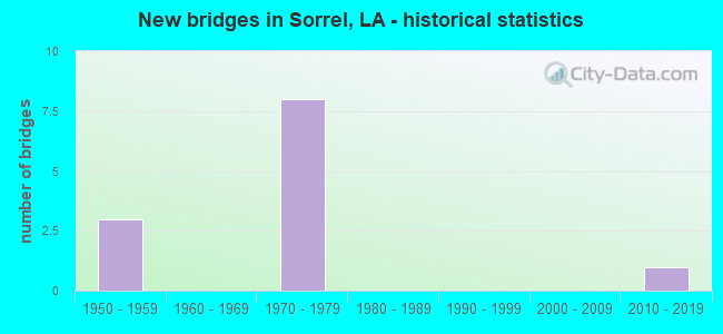
- New bridges - historical statistics
- 31950-1959
- 81970-1979
- 12010-2019


- Bridge Condition - Deck
- 11.1%Very good
- 44.4%Good
- 44.4%Satisfactory

- Bridge Condition - Superstructure
- 11.1%Very good
- 44.4%Good
- 44.4%Satisfactory

- Bridge Condition - Substructure
- 11.1%Very good
- 33.3%Good
- 55.6%Satisfactory

- Bridge Condition - Channel
- 63.6%Very good
- 36.4%Good

- Bridge Condition - Culverts
- 66.7%Good
- 33.3%Satisfactory
Find on map >> Show street view
Structure Number: 35100000030508, Location: 3.1 MI E OF LA 668 (Lat: 29.867689, Lng: -91.636269), Route carried "on" structure: US 90, Year Built: 2017, Status: Open, Structure Length: 57.52m (188.71ft), Average Daily Traffic: 11,470 (year 2015), Truck Traffic: 24%, Average Future Daily Traffic: 17,045 (year 2035), Design Load: Greater than HL93, Features Intersected: LA 318
Minimum Vertical Clearance: 30+ m (98+ ft), Kilometerpoint: 4.339, Lanes on structure: 2, Lanes under structure: 2, Owner: State Highway Agency, Approaching Roadway Width: 12.2m (40.0ft), Material/Design: Concrete continuous, Design/Construction: Stringer/Multi-beam, Number Of Spans In Main Unit: 17, Length of Maximum Span: 33.8m (110.9ft), Curb-To-Curb Width: 12.8m (42.0ft), Out-to-Out Width: 13.4m (44.0ft)
Condition: Deck: Very good, Superstructure: Very good, Substructure: Very good, Operating Rating: 72.3 metric tons, Method Used To Determine Operating Rating: Load and Resistance Factor Rating (LRFR) rating reported by rating factor(RF) method using HL-93 loadings, Inventory Rating: 46.0 metric tons, Method Used To Determine Inventory Rating: Load and Resistance Factor Rating (LRFR) rating reported by rating factor(RF) method using HL-93 loadings, Structural Evaluation: Equal to present desirable criteria, Deck Geometry: Equal to present desirable criteria, Underclear: Superior to present desirable criteria, Approach Roadway Alignment: Equal to present desirable criteria, Designated Inspection Frequency: Every 24 months, Inspection Date: August 2021, Deck Structure Type: Concrete Cast-file-Place
Find on map >> Show street view
Structure Number: 35102390211201, Location: 2.80 MI WEST OF US 90 (Lat: 29.835700, Lng: -91.630100), Route carried "on" structure: State highway 83, Year Built: 1954, Status: Open, Structure Length: 0.82m (2.69ft), Average Daily Traffic: 920 (year 2016), Truck Traffic: 13%, Average Future Daily Traffic: 1,683 (year 2036), Design Load: H 15, Features Intersected: KELLY CANAL
Minimum Vertical Clearance: 30+ m (98+ ft), Kilometerpoint: 18.293, Lanes on structure: 2, Owner: State Highway Agency, Approaching Roadway Width: 6.2m (20.3ft), Material/Design: Concrete, Design/Construction: Culvert, Number Of Spans In Main Unit: 3, Length of Maximum Span: 2.4m (7.9ft), Curb-To-Curb Width: 11.0m (36.1ft), Out-to-Out Width: 11.3m (37.1ft)
Condition: Channel: Very good, Culverts: Good, Operating Rating: 31.1 metric tons, Method Used To Determine Operating Rating: Load and Resistance Factor Rating (LRFR) rating reported by rating factor(RF) method using HL-93 loadings, Inventory Rating: 24.0 metric tons, Method Used To Determine Inventory Rating: Load and Resistance Factor Rating (LRFR) rating reported by rating factor(RF) method using HL-93 loadings, Structural Evaluation: Equal to present minimum criteria, Deck Geometry: Better than present minimum criteria, Waterway Adequacy: Better than present minimum criteria, Approach Roadway Alignment: Equal to present desirable criteria, Designated Inspection Frequency: Every 24 months, Underwater Inspection Frequency: Every 60 months, Inspection Date: August 2021, Underwater Inspection Date: July 2020, Deck Structure Type: Concrete Cast-file-Place
Find on map >> Show street view
Structure Number: 35102390212091, Location: 1.91 MI WEST OF US 90 (Lat: 29.836000, Lng: -91.615600), Route carried "on" structure: State highway 83, Year Built: 1954, Status: Open, Structure Length: 1.16m (3.81ft), Average Daily Traffic: 920 (year 2016), Truck Traffic: 13%, Average Future Daily Traffic: 1,683 (year 2036), Design Load: H 15, Features Intersected: CREEK
Minimum Vertical Clearance: 30+ m (98+ ft), Kilometerpoint: 19.697, Lanes on structure: 2, Owner: State Highway Agency, Approaching Roadway Width: 10.7m (35.1ft), Skew: 6 degrees, Material/Design: Concrete, Design/Construction: Culvert, Number Of Spans In Main Unit: 3, Length of Maximum Span: 2.4m (7.9ft), Curb-To-Curb Width: 12.5m (41.0ft), Out-to-Out Width: 12.8m (42.0ft)
Condition: Channel: Very good, Culverts: Good, Operating Rating: 42.1 metric tons, Method Used To Determine Operating Rating: Load and Resistance Factor Rating (LRFR) rating reported by rating factor(RF) method using HL-93 loadings, Inventory Rating: 32.4 metric tons, Method Used To Determine Inventory Rating: Load and Resistance Factor Rating (LRFR) rating reported by rating factor(RF) method using HL-93 loadings, Structural Evaluation: Better than present minimum criteria, Deck Geometry: Superior to present desirable criteria, Waterway Adequacy: Equal to present desirable criteria, Approach Roadway Alignment: Equal to present desirable criteria, Designated Inspection Frequency: Every 24 months, Inspection Date: June 2021, Deck Structure Type: Concrete Cast-file-Place
Find on map >> Show street view
Structure Number: 35104240502193, Location: 2.71 MI EAST OF LA 671 (Lat: 29.871039, Lng: -91.643631), Route carried "on" structure: ServiceUS 90, Year Built: 1973, Status: Open, Structure Length: 1.16m (3.81ft), Average Daily Traffic: 2,240 (year 2016), Truck Traffic: 13%, Average Future Daily Traffic: 3,655 (year 2035), Design Load: HS 20, Features Intersected: DRAIN
Minimum Vertical Clearance: 30+ m (98+ ft), Kilometerpoint: 3.534, Lanes on structure: 2, Owner: State Highway Agency, Approaching Roadway Width: 5.5m (18.0ft), Material/Design: Concrete, Design/Construction: Slab, Number Of Spans In Main Unit: 2, Length of Maximum Span: 5.8m (19.0ft), Curb-To-Curb Width: 7.3m (24.0ft), Out-to-Out Width: 8.7m (28.5ft)
Condition: Deck: Satisfactory, Superstructure: Satisfactory, Substructure: Satisfactory, Channel: Good, Operating Rating: 44.4 metric tons, Method Used To Determine Operating Rating: Load Factor (LF), Inventory Rating: 26.3 metric tons, Method Used To Determine Inventory Rating: Load Factor (LF), Structural Evaluation: Equal to present minimum criteria, Deck Geometry: High priority of replacement, Waterway Adequacy: Equal to present desirable criteria, Approach Roadway Alignment: Equal to present desirable criteria, Length Of Structure Improvement: 1.80m (5.91ft), Designated Inspection Frequency: Every 24 months, Inspection Date: November 2021, Bridge Improvement Cost: $153,000, Roadway Improvement Cost: $15,000, Total Project Cost: $229,000 ( Estimate for 2015), Deck Structure Type: Concrete Cast-file-Place, Wearing Surface/Protective System: Wearing Surface: Bituminous
Find on map >> Show street view
Structure Number: 35104240502491, Location: 2.99MI EAST OF LA 671 (Lat: 29.869581, Lng: -91.640169), Route carried "on" structure: US 90, Year Built: 1973, Status: Open, Structure Length: 0.85m (2.79ft), Average Daily Traffic: 22,400 (year 2016), Truck Traffic: 24%, Average Future Daily Traffic: 36,550 (year 2035), Design Load: HS 20, Features Intersected: DRAIN
Minimum Vertical Clearance: 30+ m (98+ ft), Kilometerpoint: 3.903, Lanes on structure: 8, Base Highway Network: Yes (Inventory Route: 424-05-1, Subroute: 10), Owner: State Highway Agency, Approaching Roadway Width: 40.2m (131.9ft), Skew: 10 degrees, Material/Design: Concrete, Design/Construction: Culvert, Length of Maximum Span: 8.5m (27.9ft), Curb-To-Curb Width: 23.2m (76.1ft), Out-to-Out Width: 106.3m (348.8ft)
Condition: Channel: Good, Culverts: Satisfactory, Operating Rating: 42.1 metric tons, Method Used To Determine Operating Rating: Load and Resistance Factor Rating (LRFR) rating reported by rating factor(RF) method using HL-93 loadings, Inventory Rating: 32.4 metric tons, Method Used To Determine Inventory Rating: Load and Resistance Factor Rating (LRFR) rating reported by rating factor(RF) method using HL-93 loadings, Structural Evaluation: Equal to present minimum criteria, Deck Geometry: High priority of replacement, Waterway Adequacy: Equal to present desirable criteria, Approach Roadway Alignment: Equal to present desirable criteria, Designated Inspection Frequency: Every 24 months, Inspection Date: November 2021, Deck Structure Type: Concrete Cast-file-Place
Find on map >> Show street view
Structure Number: 35104240504231, Location: 1.4 MI EAST OF LA 318 (Lat: 29.857039, Lng: -91.612139), Route carried "on" structure: US 90, Year Built: 1978, Status: Open, Structure Length: 1.83m (6.00ft), Average Daily Traffic: 10,150 (year 2016), Truck Traffic: 24%, Average Future Daily Traffic: 20,094 (year 2035), Design Load: HS 20, Features Intersected: VACHERIE CANAL
Minimum Vertical Clearance: 30+ m (98+ ft), Kilometerpoint: 6.944, Lanes on structure: 2, Base Highway Network: Yes (Inventory Route: 424-05-1, Subroute: 10), Owner: State Highway Agency, Approaching Roadway Width: 12.2m (40.0ft), Skew: 16 degrees, Material/Design: Concrete, Design/Construction: Slab, Number Of Spans In Main Unit: 3, Length of Maximum Span: 6.1m (20.0ft), Curb-To-Curb Width: 12.2m (40.0ft), Out-to-Out Width: 13.2m (43.3ft)
Condition: Deck: Good, Superstructure: Good, Substructure: Satisfactory, Channel: Very good, Operating Rating: 72.6 metric tons, Method Used To Determine Operating Rating: Load Factor (LF), Inventory Rating: 43.5 metric tons, Method Used To Determine Inventory Rating: Load Factor (LF), Structural Evaluation: Equal to present minimum criteria, Deck Geometry: Better than present minimum criteria, Waterway Adequacy: Equal to present desirable criteria, Approach Roadway Alignment: Equal to present desirable criteria, Designated Inspection Frequency: Every 24 months, Inspection Date: September 2020, Deck Structure Type: Concrete Cast-file-Place
Find on map >> Show street view
Structure Number: 35104240504232, Location: 3.24 Mi W of LA 83 (Lat: 29.857189, Lng: -91.611889), Route carried "on" structure: US 90, Year Built: 1978, Status: Open, Structure Length: 1.83m (6.00ft), Average Daily Traffic: 10,150 (year 2016), Truck Traffic: 24%, Average Future Daily Traffic: 20,094 (year 2035), Design Load: HS 20, Features Intersected: VACHERIE CANAL
Minimum Vertical Clearance: 30+ m (98+ ft), Kilometerpoint: 57.951, Lanes on structure: 2, Base Highway Network: Yes (Inventory Route: 424-05-2, Subroute: 10), Owner: State Highway Agency, Approaching Roadway Width: 12.2m (40.0ft), Skew: 16 degrees, Material/Design: Concrete, Design/Construction: Slab, Number Of Spans In Main Unit: 3, Length of Maximum Span: 6.1m (20.0ft), Curb-To-Curb Width: 12.2m (40.0ft), Out-to-Out Width: 13.2m (43.3ft)
Condition: Deck: Good, Superstructure: Good, Substructure: Good, Channel: Very good, Operating Rating: 72.6 metric tons, Method Used To Determine Operating Rating: Load Factor (LF), Inventory Rating: 43.5 metric tons, Method Used To Determine Inventory Rating: Load Factor (LF), Structural Evaluation: Better than present minimum criteria, Deck Geometry: Better than present minimum criteria, Waterway Adequacy: Equal to present desirable criteria, Approach Roadway Alignment: Equal to present desirable criteria, Designated Inspection Frequency: Every 24 months, Inspection Date: November 2020, Deck Structure Type: Concrete Cast-file-Place
Find on map >> Show street view
Structure Number: 35104240504233, Location: 1.4 MI EAST OF LA 318 (Lat: 29.856789, Lng: -91.612239), Route carried "on" structure: ServiceUS 90, Year Built: 1978, Status: Open, Structure Length: 1.83m (6.00ft), Average Daily Traffic: 2,030 (year 2016), Truck Traffic: 13%, Average Future Daily Traffic: 3,349 (year 2035), Design Load: HS 20, Features Intersected: VACHERIE CANAL
Minimum Vertical Clearance: 30+ m (98+ ft), Kilometerpoint: 1.595, Lanes on structure: 2, Owner: State Highway Agency, Approaching Roadway Width: 9.8m (32.2ft), Skew: 6 degrees, Material/Design: Concrete, Design/Construction: Slab, Number Of Spans In Main Unit: 3, Length of Maximum Span: 6.1m (20.0ft), Curb-To-Curb Width: 8.6m (28.2ft), Out-to-Out Width: 9.5m (31.2ft)
Condition: Deck: Good, Superstructure: Good, Substructure: Good, Channel: Very good, Operating Rating: 72.6 metric tons, Method Used To Determine Operating Rating: Load Factor (LF), Inventory Rating: 43.5 metric tons, Method Used To Determine Inventory Rating: Load Factor (LF), Structural Evaluation: Better than present minimum criteria, Deck Geometry: Meets minimum limits, Waterway Adequacy: Equal to present desirable criteria, Approach Roadway Alignment: Equal to present desirable criteria, Designated Inspection Frequency: Every 24 months, Inspection Date: September 2020, Deck Structure Type: Concrete Cast-file-Place
Find on map >> Show street view
Structure Number: 35104240504234, Location: 3.24 Mi W of LA 83 (Lat: 29.857469, Lng: -91.611869), Route carried "on" structure: ServiceUS 90, Year Built: 1978, Status: Open, Structure Length: 1.83m (6.00ft), Average Daily Traffic: 2,030 (year 2016), Truck Traffic: 13%, Average Future Daily Traffic: 3,349 (year 2035), Design Load: HS 20, Features Intersected: VACHERIE CANAL
Minimum Vertical Clearance: 30+ m (98+ ft), Kilometerpoint: 5.452, Lanes on structure: 2, Owner: State Highway Agency, Approaching Roadway Width: 9.8m (32.2ft), Skew: 6 degrees, Material/Design: Concrete, Design/Construction: Slab, Number Of Spans In Main Unit: 3, Length of Maximum Span: 6.1m (20.0ft), Curb-To-Curb Width: 8.9m (29.2ft), Out-to-Out Width: 9.5m (31.2ft)
Condition: Deck: Good, Superstructure: Good, Substructure: Good, Channel: Very good, Operating Rating: 72.6 metric tons, Method Used To Determine Operating Rating: Load Factor (LF), Inventory Rating: 43.5 metric tons, Method Used To Determine Inventory Rating: Load Factor (LF), Structural Evaluation: Better than present minimum criteria, Deck Geometry: Meets minimum limits, Waterway Adequacy: Equal to present desirable criteria, Approach Roadway Alignment: Equal to present desirable criteria, Designated Inspection Frequency: Every 24 months, Inspection Date: November 2020, Deck Structure Type: Concrete Cast-file-Place
Find on map >> Show street view
Structure Number: 35129506913691, Location: 0.52 Mi N of La 83 (Lat: 29.843419, Lng: -91.614539), Route carried "on" structure: County highway , Year Built: 1972, Status: Open, Structure Length: 1.16m (3.81ft), Average Daily Traffic: 30 (year 1971), Average Future Daily Traffic: 51 (year 2035), Design Load: HS 20, Features Intersected: COULEE, Facility Carried by Structure: Dumesnil Rd
Minimum Vertical Clearance: 30+ m (98+ ft), Kilometerpoint: 0.000, Lanes on structure: 2, Owner: County Highway Agency, Approaching Roadway Width: 7.3m (24.0ft), Skew: 3 degrees, Material/Design: Concrete, Design/Construction: Slab, Number Of Spans In Main Unit: 2, Length of Maximum Span: 5.8m (19.0ft), Curb-To-Curb Width: 8.6m (28.2ft), Out-to-Out Width: 9.5m (31.2ft)
Condition: Deck: Satisfactory, Superstructure: Satisfactory, Substructure: Satisfactory, Channel: Good, Operating Rating: 38.9 metric tons, Method Used To Determine Operating Rating: Load and Resistance Factor Rating (LRFR) rating reported by rating factor(RF) method using HL-93 loadings, Inventory Rating: 30.1 metric tons, Method Used To Determine Inventory Rating: Load and Resistance Factor Rating (LRFR) rating reported by rating factor(RF) method using HL-93 loadings, Structural Evaluation: Equal to present minimum criteria, Deck Geometry: Better than present minimum criteria, Waterway Adequacy: Equal to present desirable criteria, Approach Roadway Alignment: Equal to present minimum criteria, Designated Inspection Frequency: Every 24 months, Inspection Date: April 2021, Deck Structure Type: Concrete Cast-file-Place
Find on map >> Show street view
Structure Number: 35129506913771, Location: 1.5 Mi SE of LA 318 (Lat: 29.843331, Lng: -91.626619), Route carried "on" structure: County highway , Year Built: 1958, Status: Posted for load, Structure Length: 1.19m (3.90ft), Average Daily Traffic: 210 (year 1971), Average Future Daily Traffic: 357 (year 2035), Design Load: HS 15, Features Intersected: KELLY CANAL, Facility Carried by Structure: Cypremort Rd.
Minimum Vertical Clearance: 30+ m (98+ ft), Kilometerpoint: 0.000, Lanes on structure: 2, Owner: County Highway Agency, Approaching Roadway Width: 7.9m (25.9ft), Skew: 3 degrees, Material/Design: Concrete, Design/Construction: Slab, Number Of Spans In Main Unit: 2, Length of Maximum Span: 6.1m (20.0ft), Curb-To-Curb Width: 7.3m (24.0ft), Out-to-Out Width: 9.1m (29.9ft)
Condition: Deck: Satisfactory, Superstructure: Satisfactory, Substructure: Satisfactory, Channel: Good, Operating Rating: 25.3 metric tons, Method Used To Determine Operating Rating: Load and Resistance Factor Rating (LRFR) rating reported by rating factor(RF) method using HL-93 loadings, Inventory Rating: 19.4 metric tons, Method Used To Determine Inventory Rating: Load and Resistance Factor Rating (LRFR) rating reported by rating factor(RF) method using HL-93 loadings, Structural Evaluation: Somewhat better than minimum adequacy, Deck Geometry: Somewhat better than minimum adequacy, Waterway Adequacy: Better than present minimum criteria, Approach Roadway Alignment: Equal to present desirable criteria, Length Of Structure Improvement: 1.83m (6.00ft), Designated Inspection Frequency: Every 24 months, Underwater Inspection Frequency: Every 60 months, Inspection Date: April 2021, Underwater Inspection Date: January 2019, Bridge Improvement Cost: $109,000, Roadway Improvement Cost: $10,000, Total Project Cost: $163,000 ( Estimate for 2015), Deck Structure Type: Concrete Cast-file-Place
Find on map >> Show street view
Structure Number: 35129535913681, Location: 0.2 Mi N of LA 182 (Lat: 29.892619, Lng: -91.613831), Route carried "on" structure: County highway , Year Built: 1972, Status: Posted for load, Structure Length: 11.16m (36.61ft), Average Daily Traffic: 200 (year 1978), Average Future Daily Traffic: 340 (year 2035), Design Load: H 15, Features Intersected: TECHE BAYOU, Facility Carried by Structure: Sorrell Bridge Rd
Minimum Vertical Clearance: 5.03m (16.50ft), Kilometerpoint: 0.000, Lanes on structure: 2, Owner: County Highway Agency, Approaching Roadway Width: 9.8m (32.2ft), Navigation Control: Yes ( Vertical Clearance: 2.4m (7.9ft), Horizontal Clearance: 18.6m (61.0ft)), Material/Design: Steel, Design/Construction: Movable - Swing, Number Of Spans In Main Unit: 1, Number Of Approach Spans: 9, Length of Maximum Span: 54.9m (180.1ft), Curb-To-Curb Width: 7.3m (24.0ft), Out-to-Out Width: 8.9m (29.2ft)
Condition: Deck: Satisfactory, Superstructure: Satisfactory, Substructure: Satisfactory, Channel: Very good, Operating Rating: 28.2 metric tons, Method Used To Determine Operating Rating: Load and Resistance Factor Rating (LRFR) rating reported by rating factor(RF) method using HL-93 loadings, Inventory Rating: 21.7 metric tons, Method Used To Determine Inventory Rating: Load and Resistance Factor Rating (LRFR) rating reported by rating factor(RF) method using HL-93 loadings, Structural Evaluation: Equal to present minimum criteria, Deck Geometry: Somewhat better than minimum adequacy, Waterway Adequacy: Equal to present desirable criteria, Approach Roadway Alignment: Equal to present desirable criteria, Bridge Posting: Required (Relationship of Operating Rating to Maximum Legal Load: 10.0 - 19.9% below), Designated Inspection Frequency: Every 24 months, Critical Feature Inspection Frequency: Every 24 months, Underwater Inspection Frequency: Every 60 months, Inspection Date: April 2021, Critical Feature Inspection Date: April 2021, Underwater Inspection Date: June 2018, Deck Structure Type: Open Grating
Find on map >> Show street view
Structure Number: 35100000030507, Location: LA 318 UNDER US 90 WB (Lat: 29.866000, Lng: -91.633500), Route carried "under" structure: State highway 318, Structure Length: 0. m, Average Daily Traffic: 2,009 (year 2014), Features Intersected: LA 318, Facility Carried by Structure: US 90
Minimum Vertical Clearance: 5.24m (17.19ft), Kilometerpoint: 4.558, Lanes on structure: 2, Lanes under structure: 2, Length of Maximum Span: 0.0m
Find on map >> Show street view
Structure Number: 35100000030508, Location: 0.9 MI. E OF LA 668 (Lat: 29.866000, Lng: -91.633500), Route carried "under" structure: State highway 318, Structure Length: 0. m, Average Daily Traffic: 2,000 (year 2017), Features Intersected: LA 318, Facility Carried by Structure: US 90
Minimum Vertical Clearance: 5.18m (16.99ft), Kilometerpoint: 4.558, Lanes on structure: 2, Lanes under structure: 2, Length of Maximum Span: 0.0m