Bridge Statistics for Souderton, Pennsylvania (PA)
Condition, Traffic, Stress, Structural Evaluation, Project Costs
- National Bridge Inventory (NBI) Statistics
- 15Number of bridges
- 56ft / 16.6mTotal length
- $1,697,000Total costs
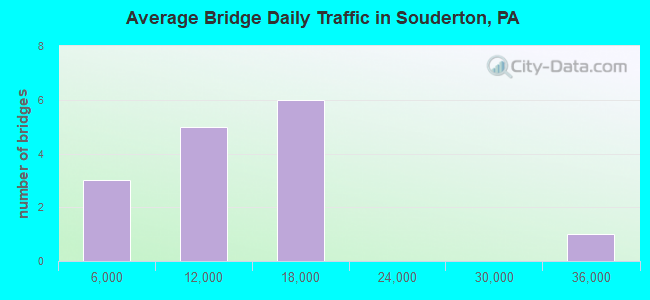
- 180,621Total average daily traffic
- 13,844Total average daily truck traffic
- National Bridge Inventory (NBI) Registered Bridges for Souderton
- No street view available for this location
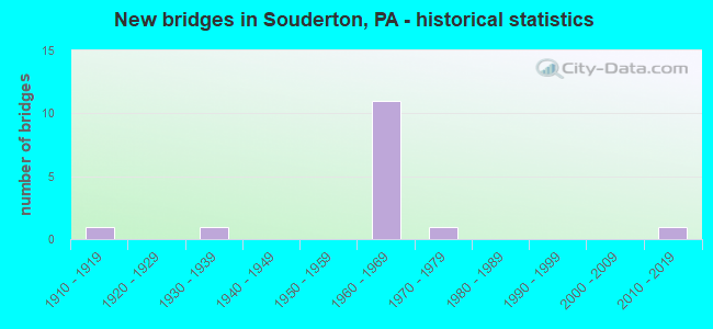
- New bridges - historical statistics
- 11910-1919
- 11930-1939
- 111960-1969
- 11970-1979
- 12010-2019
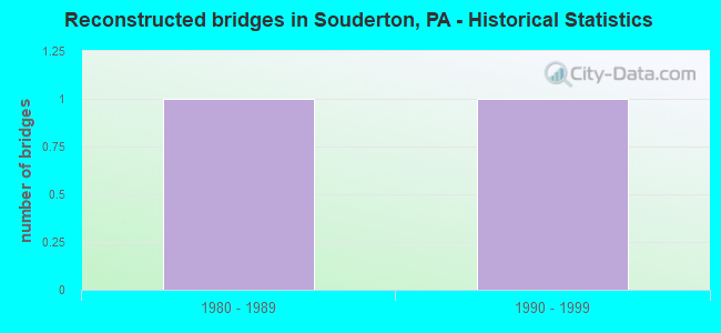
- Reconstructed bridges - Historical Statistics
- 11980-1989
- 11990-1999
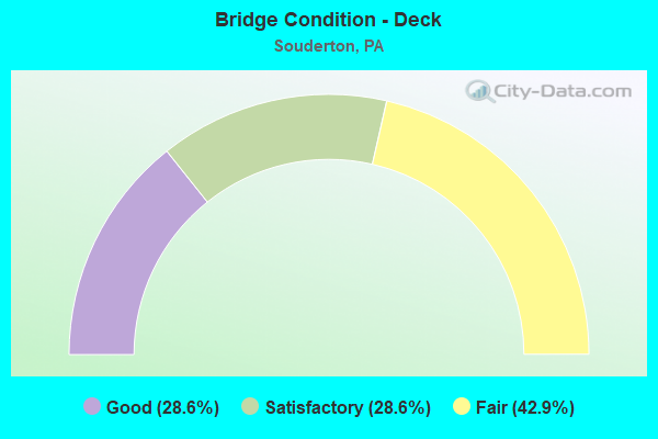
- Bridge Condition - Deck
- 28.6%Good
- 28.6%Satisfactory
- 42.9%Fair
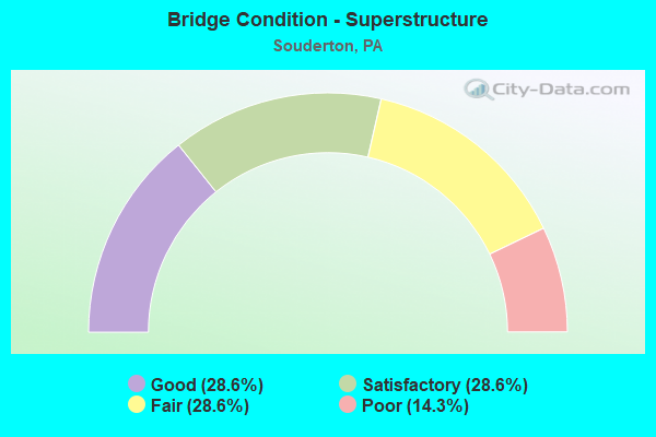
- Bridge Condition - Superstructure
- 28.6%Good
- 28.6%Satisfactory
- 28.6%Fair
- 14.3%Poor
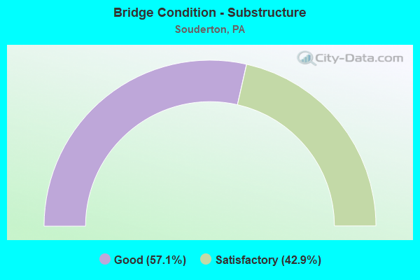
- Bridge Condition - Substructure
- 57.1%Good
- 42.9%Satisfactory
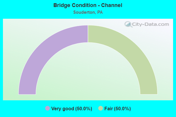
- Bridge Condition - Channel
- 50.0%Very good
- 50.0%Fair
Find on map >> Show street view
Structure Number: 6882, Location: SOUTH TELFORD 20E11 (Lat: 40.317250, Lng: -75.308369), Route carried "on" structure: State highway 113, Year Built: 1967, Status: Open, Structure Length: 2.90m (9.51ft), Average Daily Traffic: 9,324 (year 2022), Truck Traffic: 5%, Average Future Daily Traffic: 14,000 (year 2032), Design Load: H 20, Features Intersected: SELLERSVILLE BYPASS, Facility Carried by Structure: SOUDERTON ROAD
Minimum Vertical Clearance: 30+ m (98+ ft), Kilometerpoint: 0.000, Lanes on structure: 2, Lanes under structure: 4, Base Highway Network: Yes, Owner: State Highway Agency, Approaching Roadway Width: 21.3m (69.9ft), Skew: 21 degrees, Material/Design: Prestressed concrete, Design/Construction: Stringer/Multi-beam, Number Of Spans In Main Unit: 1, Length of Maximum Span: 27.7m (90.9ft), Curb or Sidewalk Widths: Left: 0.4m (1.3ft), Right: 0.4m (1.3ft), Curb-To-Curb Width: 20.7m (67.9ft), Out-to-Out Width: 22.4m (73.5ft)
Condition: Deck: Fair, Superstructure: Fair, Substructure: Good, Operating Rating: 80.7 metric tons, Method Used To Determine Operating Rating: Load Factor (LF), Inventory Rating: 21.8 metric tons, Method Used To Determine Inventory Rating: Load Factor (LF), Structural Evaluation: Somewhat better than minimum adequacy, Deck Geometry: Superior to present desirable criteria, Underclear: High priority of corrective action, Approach Roadway Alignment: Equal to present desirable criteria, Length Of Structure Improvement: 3.50m (11.48ft), Designated Inspection Frequency: Every 24 months, Inspection Date: January 2021, Deck Structure Type: Concrete Cast-file-Place, Wearing Surface/Protective System: Wearing Surface: Monolithic Concrete
Find on map >> Show street view
Structure Number: 6967, Location: .2 MI.TO LR 09081 20G13 (Lat: 40.306019, Lng: -75.295794), Route carried "on" structure: State highway 309, Year Built: 1967, Status: Open, Structure Length: 1.80m (5.91ft), Average Daily Traffic: 34,034 (year 2022), Truck Traffic: 9%, Average Future Daily Traffic: 39,765 (year 2032), Design Load: HS 20, Features Intersected: SR 4085 BETHLEHEM PIKE, Facility Carried by Structure: SELLERSVILLE BYPAS
Minimum Vertical Clearance: 30+ m (98+ ft), Kilometerpoint: 3.204, Lanes on structure: 2, Lanes under structure: 2, Base Highway Network: Yes, Owner: State Highway Agency, Approaching Roadway Width: 25.6m (84.0ft), Skew: 33 degrees, Material/Design: Prestressed concrete, Design/Construction: Box Beam or Girders - Single/Spread, Number Of Spans In Main Unit: 1, Length of Maximum Span: 17.7m (58.1ft), Curb or Sidewalk Widths: Left: 0.2m (0.7ft), Right: 0.2m (0.7ft), Curb-To-Curb Width: 25.0m (82.0ft), Out-to-Out Width: 26.8m (87.9ft)
Condition: Deck: Good, Superstructure: Good, Substructure: Good, Operating Rating: 62.6 metric tons, Method Used To Determine Operating Rating: Load Factor (LF), Inventory Rating: 26.3 metric tons, Method Used To Determine Inventory Rating: Load Factor (LF), Structural Evaluation: Equal to present minimum criteria, Deck Geometry: Superior to present desirable criteria, Underclear: Meets minimum limits, Approach Roadway Alignment: Equal to present desirable criteria, Length Of Structure Improvement: 1.80m (5.91ft), Designated Inspection Frequency: Every 24 months, Inspection Date: Febuary 2021, Bridge Improvement Cost: $26,000, Roadway Improvement Cost: $77,000, Total Project Cost: $352,000, Deck Structure Type: Concrete Cast-file-Place, Wearing Surface/Protective System: Wearing Surface: Monolithic Concrete
Find on map >> Show street view
Structure Number: 7456, Location: 3.5MI.S.SELLERSVIL.20F11 (Lat: 40.314953, Lng: -75.303847), Route carried "on" structure: State highway , Year Built: 1967, Status: Open, Structure Length: 2.96m (9.71ft), Average Daily Traffic: 11,060 (year 2022), Truck Traffic: 8%, Average Future Daily Traffic: 12,742 (year 2032), Design Load: HS 20, Features Intersected: PA 309 BYPASS 2920B10, Facility Carried by Structure: BETHLEHEM PK
Minimum Vertical Clearance: 30+ m (98+ ft), Kilometerpoint: 2.100, Lanes on structure: 3, Lanes under structure: 4, Owner: State Highway Agency, Approaching Roadway Width: 20.7m (67.9ft), Skew: 22 degrees, Material/Design: Prestressed concrete, Design/Construction: Stringer/Multi-beam, Number Of Spans In Main Unit: 1, Length of Maximum Span: 28.3m (92.8ft), Curb or Sidewalk Widths: Left: 0.5m (1.6ft), Right: 0.5m (1.6ft), Curb-To-Curb Width: 20.7m (67.9ft), Out-to-Out Width: 22.4m (73.5ft)
Condition: Deck: Fair, Superstructure: Satisfactory, Substructure: Good, Operating Rating: 71.7 metric tons, Method Used To Determine Operating Rating: Load Factor (LF), Inventory Rating: 22.7 metric tons, Method Used To Determine Inventory Rating: Load Factor (LF), Structural Evaluation: Somewhat better than minimum adequacy, Deck Geometry: Superior to present desirable criteria, Underclear: High priority of corrective action, Approach Roadway Alignment: Better than present minimum criteria, Length Of Structure Improvement: 3.60m (11.81ft), Designated Inspection Frequency: Every 24 months, Inspection Date: December 2020, Bridge Improvement Cost: $38,000, Roadway Improvement Cost: $111,000, Total Project Cost: $510,000, Deck Structure Type: Concrete Cast-file-Place, Wearing Surface/Protective System: Wearing Surface: Bituminous
Find on map >> Show street view
Structure Number: 7615, Location: EAST OF SOUDERTON 3032-C1 (Lat: 40.309044, Lng: -75.297942), Route carried "on" structure: State highway , Year Built: 1967, Status: Open, Structure Length: 2.71m (8.89ft), Average Daily Traffic: 1,625 (year 2019), Truck Traffic: 1%, Average Future Daily Traffic: 1,800 (year 2039), Design Load: HS 20, Features Intersected: SELLERSVILLE BYPASS, Facility Carried by Structure: FAIRHILL ROAD
Minimum Vertical Clearance: 30+ m (98+ ft), Kilometerpoint: 0.000, Lanes on structure: 2, Lanes under structure: 8, Owner: Town or Township Highway Agency, Approaching Roadway Width: 8.5m (27.9ft), Skew: 1 degrees, Material/Design: Prestressed concrete, Design/Construction: Stringer/Multi-beam, Number Of Spans In Main Unit: 1, Length of Maximum Span: 26.2m (86.0ft), Curb or Sidewalk Widths: Left: 0.5m (1.6ft), Right: 0.5m (1.6ft), Curb-To-Curb Width: 8.5m (27.9ft), Out-to-Out Width: 10.2m (33.5ft)
Condition: Deck: Fair, Superstructure: Fair, Substructure: Good, Operating Rating: 73.5 metric tons, Method Used To Determine Operating Rating: Load Factor (LF), Inventory Rating: 20.0 metric tons, Method Used To Determine Inventory Rating: Load Factor (LF), Structural Evaluation: Somewhat better than minimum adequacy, Deck Geometry: Somewhat better than minimum adequacy, Underclear: High priority of corrective action, Approach Roadway Alignment: Equal to present minimum criteria, Length Of Structure Improvement: 3.50m (11.48ft), Designated Inspection Frequency: Every 24 months, Inspection Date: April 2020, Bridge Improvement Cost: $8,000, Roadway Improvement Cost: $25,000, Total Project Cost: $113,000, Deck Structure Type: Concrete Cast-file-Place, Wearing Surface/Protective System: Wearing Surface: Monolithic Concrete
Find on map >> Show street view
Structure Number: 28234, Location: E. OF RR AVE. 2919-H10 (Lat: 40.315300, Lng: -75.326997), Route carried "on" structure: City street , Year Built: 1930, Year Reconstructed: 1986, Status: Open, Structure Length: 2.99m (9.81ft), Average Daily Traffic: 1,500 (year 2018), Truck Traffic: 5%, Average Future Daily Traffic: 2,500 (year 2038), Design Load: HS 20, Features Intersected: SEPTA/PA Northeastern RR, Facility Carried by Structure: EAST SUMMIT STREET
Minimum Vertical Clearance: 30+ m (98+ ft), Kilometerpoint: 0.000, Lanes on structure: 2, Owner: Town or Township Highway Agency, Approaching Roadway Width: 10.4m (34.1ft), Skew: 1 degrees, Material/Design: Steel, Design/Construction: Girder and Floorbeam System, Number Of Spans In Main Unit: 1, Length of Maximum Span: 28.0m (91.9ft), Curb-To-Curb Width: 6.3m (20.7ft), Out-to-Out Width: 6.7m (22.0ft)
Condition: Deck: Satisfactory, Superstructure: Poor, Substructure: Satisfactory, Operating Rating: 49.0 metric tons, Method Used To Determine Operating Rating: Load Factor (LF), Inventory Rating: 29.0 metric tons, Method Used To Determine Inventory Rating: Load Factor (LF), Structural Evaluation: Meets minimum limits, Deck Geometry: High priority of replacement, Underclear: High priority of corrective action, Approach Roadway Alignment: Equal to present desirable criteria, Length Of Structure Improvement: 3.70m (12.14ft), Designated Inspection Frequency: Every 24 months, Critical Feature Inspection Frequency: Every 12 months, Other Special Inspection Frequency: Every 12 months, Inspection Date: Febuary 2021, Critical Feature Inspection Date: Febuary 2021, Other Special Inspection Date: Febuary 2021, Bridge Improvement Cost: $21,000, Roadway Improvement Cost: $63,000, Total Project Cost: $288,000, Deck Structure Type: Concrete Cast-file-Place, Wearing Surface/Protective System: Wearing Surface: Monolithic Concrete
Find on map >> Show street view
Structure Number: 28235, Location: 1MI.SE.BORO HALL 3031-K2 (Lat: 40.305500, Lng: -75.314997), Route carried "on" structure: City street , Year Built: 1910, Year Reconstructed: 1997, Status: Open, Structure Length: 1.65m (5.41ft), Average Daily Traffic: 300 (year 1991), Average Future Daily Traffic: 420 (year 2013), Features Intersected: SEPTA LEASED TO CSX, Facility Carried by Structure: CHERRY LANE
Minimum Vertical Clearance: 30+ m (98+ ft), Kilometerpoint: 0.000, Lanes on structure: 2, Owner: Railroad, Approaching Roadway Width: 8.2m (26.9ft), Material/Design: Prestressed concrete, Design/Construction: Box Beam or Girders - Multiple, Number Of Spans In Main Unit: 1, Length of Maximum Span: 16.2m (53.1ft), Curb or Sidewalk Widths: Left: 1.3m (4.3ft), Right: 0.2m (0.7ft), Curb-To-Curb Width: 8.2m (26.9ft), Out-to-Out Width: 10.3m (33.8ft)
Condition: Deck: Good, Superstructure: Good, Substructure: Satisfactory, Inventory Rating: 64.4 metric tons, Method Used To Determine Inventory Rating: Load Factor (LF), Structural Evaluation: Equal to present minimum criteria, Deck Geometry: Somewhat better than minimum adequacy, Underclear: High priority of corrective action, Approach Roadway Alignment: Better than present minimum criteria, Length Of Structure Improvement: 2.00m (6.56ft), Designated Inspection Frequency: Every 24 months, Inspection Date: July 2019, Bridge Improvement Cost: $32,000, Roadway Improvement Cost: $95,000, Total Project Cost: $434,000, Deck Structure Type: Concrete Cast-file-Place, Wearing Surface/Protective System: Wearing Surface: Monolithic Concrete, Deck Protection: Epoxy Coated Reinforcing
Find on map >> Show street view
Structure Number: 48586, Location: 2 MI. E. I-476 3031G3 (Lat: 40.297286, Lng: -75.332847), Route carried "on" structure: City street , Year Built: 2014, Status: Open, Structure Length: 0.94m (3.08ft), Average Daily Traffic: 10,000 (year 2016), Truck Traffic: 1%, Average Future Daily Traffic: 12,000 (year 2036), Design Load: HL 93, Features Intersected: BRANCH SKIPPACK CREEK, Facility Carried by Structure: COWPATH ROAD
Minimum Vertical Clearance: 30+ m (98+ ft), Kilometerpoint: 0.000, Lanes on structure: 4, Owner: Town or Township Highway Agency, Approaching Roadway Width: 26.2m (86.0ft), Skew: 2 degrees, Material/Design: Concrete, Design/Construction: Culvert, Number Of Spans In Main Unit: 1, Length of Maximum Span: 8.5m (27.9ft), Curb or Sidewalk Widths: Left: 0.0m, Right: 2.1m (6.9ft), Curb-To-Curb Width: 26.2m (86.0ft), Out-to-Out Width: 29.9m (98.1ft)
Condition: Channel: Very good, Culverts: Very good, Operating Rating: 56.1 metric tons, Method Used To Determine Operating Rating: Assigned ratings based on Load and Resistance Factor Design (LRFD) reported by rating factor (RF) using HL93 loadings, Inventory Rating: 35.3 metric tons, Method Used To Determine Inventory Rating: Assigned ratings based on Load and Resistance Factor Design (LRFD) reported by rating factor (RF) using HL93 loadings, Structural Evaluation: Equal to present desirable criteria, Deck Geometry: Superior to present desirable criteria, Waterway Adequacy: Equal to present minimum criteria, Approach Roadway Alignment: Equal to present desirable criteria, Designated Inspection Frequency: Every 24 months, Inspection Date: December 2020, Deck Structure Type: Concrete Cast-file-Place, Wearing Surface/Protective System: Wearing Surface: Bituminous, Membrane: Other, Deck Protection: Epoxy Coated Reinforcing
Find on map >> Show street view
Structure Number: 5717, Location: E OF MEADOW WOOD LANE (Lat: 40.294361, Lng: -75.326528), Route carried "on" structure: City street , Year Built: 1970, Status: Open, Structure Length: 0.70m (2.30ft), Average Daily Traffic: 10,160 (year 2016), Truck Traffic: 1%, Average Future Daily Traffic: 11,000 (year 2036), Design Load: HS 20, Features Intersected: SKIPPACK CREEK, Facility Carried by Structure: COWPATH ROAD
Minimum Vertical Clearance: 30+ m (98+ ft), Kilometerpoint: 0.000, Lanes on structure: 2, Owner: Town or Township Highway Agency, Approaching Roadway Width: 7.3m (24.0ft), Material/Design: Concrete, Design/Construction: Slab, Number Of Spans In Main Unit: 1, Length of Maximum Span: 6.1m (20.0ft), Curb-To-Curb Width: 9.8m (32.2ft), Out-to-Out Width: 11.0m (36.1ft)
Condition: Deck: Satisfactory, Superstructure: Satisfactory, Substructure: Satisfactory, Channel: Fair, Operating Rating: 75.3 metric tons, Method Used To Determine Operating Rating: Field evaluation and documented engineering judgment, Inventory Rating: 45.4 metric tons, Method Used To Determine Inventory Rating: Field evaluation and documented engineering judgment, Structural Evaluation: Equal to present minimum criteria, Deck Geometry: Meets minimum limits, Waterway Adequacy: Equal to present minimum criteria, Approach Roadway Alignment: Better than present minimum criteria, Designated Inspection Frequency: Every 24 months, Inspection Date: December 2019, Deck Structure Type: Concrete Cast-file-Place, Wearing Surface/Protective System: Wearing Surface: Bituminous
Find on map >> Show street view
Structure Number: 6882, Location: SOUTH TELFORD 20E11 (Lat: 40.317250, Lng: -75.308369), Route carried "under" structure: State highway 309, Year Built: 1967, Structure Length: 0. m, Average Daily Traffic: 13,583 (year 2020), Truck Traffic: 8%, Features Intersected: SELLERSVILLE BYPASS, Facility Carried by Structure: SOUDERTON ROAD
Minimum Vertical Clearance: 4.82m (15.81ft), Kilometerpoint: 4.735, Lanes on structure: 2, Lanes under structure: 2, Material/Design: Prestressed concrete, Design/Construction: Stringer/Multi-beam, Length of Maximum Span: 27.7m (90.9ft)
Find on map >> Show street view
Structure Number: 6882, Location: SOUTH TELFORD 20E11 (Lat: 40.317250, Lng: -75.308369), Route carried "under" structure: State highway 309, Year Built: 1967, Structure Length: 0. m, Average Daily Traffic: 14,210 (year 2020), Truck Traffic: 10%, Features Intersected: SELLERSVILLE BYPASS, Facility Carried by Structure: SOUDERTON ROAD
Minimum Vertical Clearance: 4.50m (14.76ft), Kilometerpoint: 4.701, Lanes on structure: 2, Lanes under structure: 2, Material/Design: Prestressed concrete, Design/Construction: Stringer/Multi-beam, Length of Maximum Span: 27.7m (90.9ft)
Find on map >> Show street view
Structure Number: 6967, Location: .2 MI.TO LR 09081 20G13 (Lat: 40.306019, Lng: -75.295794), Route carried "under" structure: State highway , Year Built: 1967, Structure Length: 0. m, Average Daily Traffic: 6,757 (year 2022), Truck Traffic: 8%, Features Intersected: SR 4085 BETHLEHEM PIKE, Facility Carried by Structure: SELLERSVILLE BYPAS
Minimum Vertical Clearance: 4.97m (16.31ft), Kilometerpoint: 0.000, Lanes on structure: 2, Lanes under structure: 2, Material/Design: Prestressed concrete, Design/Construction: Box Beam or Girders - Single/Spread, Length of Maximum Span: 17.7m (58.1ft)
Find on map >> Show street view
Structure Number: 7456, Location: 3.5MI.S.SELLERSVIL.20F11 (Lat: 40.314953, Lng: -75.303847), Route carried "under" structure: State highway 309, Year Built: 1967, Structure Length: 0. m, Average Daily Traffic: 16,182 (year 2022), Truck Traffic: 10%, Features Intersected: PA 309 BYPASS 2920B10, Facility Carried by Structure: BETHLEHEM PK
Minimum Vertical Clearance: 4.52m (14.83ft), Kilometerpoint: 4.735, Lanes on structure: 3, Lanes under structure: 2, Material/Design: Prestressed concrete, Design/Construction: Stringer/Multi-beam, Length of Maximum Span: 28.3m (92.8ft)
Find on map >> Show street view
Structure Number: 7456, Location: 3.5MI.S.SELLERSVIL.20F11 (Lat: 40.314953, Lng: -75.303847), Route carried "under" structure: State highway 309, Year Built: 1967, Structure Length: 0. m, Average Daily Traffic: 17,852 (year 2022), Truck Traffic: 8%, Features Intersected: PA 309 BYPASS 2920B10, Facility Carried by Structure: BETHLEHEM PK
Minimum Vertical Clearance: 5.00m (16.40ft), Kilometerpoint: 4.701, Lanes on structure: 3, Lanes under structure: 2, Material/Design: Prestressed concrete, Design/Construction: Stringer/Multi-beam, Length of Maximum Span: 28.3m (92.8ft)
Find on map >> Show street view
Structure Number: 7615, Location: EAST OF SOUDERTON 3032-C1 (Lat: 40.309044, Lng: -75.297942), Route carried "under" structure: State highway 309, Year Built: 1967, Structure Length: 0. m, Average Daily Traffic: 16,182 (year 2022), Truck Traffic: 10%, Features Intersected: SELLERSVILLE BYPASS, Facility Carried by Structure: FAIRHILL ROAD
Minimum Vertical Clearance: 5.36m (17.59ft), Kilometerpoint: 3.887, Lanes on structure: 2, Lanes under structure: 4, Material/Design: Prestressed concrete, Design/Construction: Stringer/Multi-beam, Length of Maximum Span: 26.2m (86.0ft)
Find on map >> Show street view
Structure Number: 7615, Location: EAST OF SOUDERTON 3032-C1 (Lat: 40.309044, Lng: -75.297942), Route carried "under" structure: State highway 309, Year Built: 1967, Structure Length: 0. m, Average Daily Traffic: 17,852 (year 2022), Truck Traffic: 8%, Features Intersected: SELLERSVILLE BYPASS, Facility Carried by Structure: FAIRHILL ROAD
Minimum Vertical Clearance: 4.54m (14.90ft), Kilometerpoint: 3.870, Lanes on structure: 2, Lanes under structure: 4, Material/Design: Prestressed concrete, Design/Construction: Stringer/Multi-beam, Length of Maximum Span: 26.2m (86.0ft)