Bridge Statistics for South Amboy, New Jersey (NJ)
Condition, Traffic, Stress, Structural Evaluation, Project Costs
- National Bridge Inventory (NBI) Statistics
- 19Number of bridges
- 207ft / 63.3mTotal length
- $20,950,000Total costs
- 688,135Total average daily traffic
- 26,833Total average daily truck traffic
- National Bridge Inventory (NBI) Registered Bridges for South Amboy
- No street view available for this location
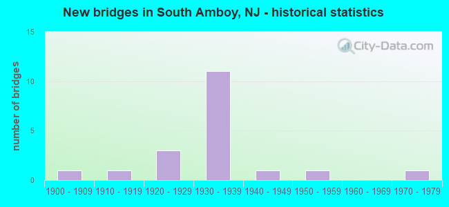
- New bridges - historical statistics
- 11900-1909
- 11910-1919
- 31920-1929
- 111930-1939
- 11940-1949
- 11950-1959
- 11970-1979
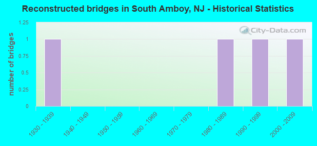
- Reconstructed bridges - Historical Statistics
- 11930-1939
- 01940-1949
- 01950-1959
- 01960-1969
- 01970-1979
- 11980-1989
- 11990-1999
- 12000-2009
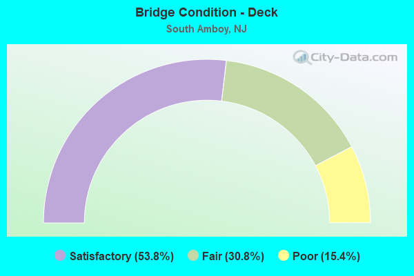
- Bridge Condition - Deck
- 53.8%Satisfactory
- 30.8%Fair
- 15.4%Poor
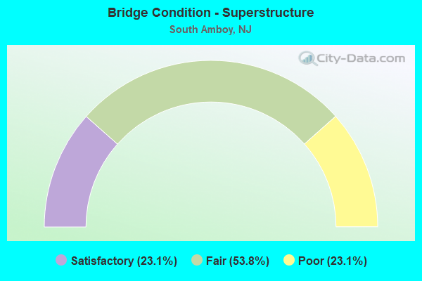
- Bridge Condition - Superstructure
- 23.1%Satisfactory
- 53.8%Fair
- 23.1%Poor
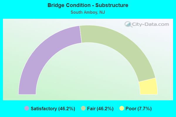
- Bridge Condition - Substructure
- 46.2%Satisfactory
- 46.2%Fair
- 7.7%Poor
Find on map >> Show street view
Structure Number: 1207151, Location: 150 FT NORTH OF RT 9 ENTR (Lat: 40.478431, Lng: -74.290239), Route carried "on" structure: County highway 684, Year Built: 1909, Year Reconstructed: 1930, Status: Open, Structure Length: 1.01m (3.31ft), Average Daily Traffic: 8,200 (year 2020), Truck Traffic: 4%, Average Future Daily Traffic: 10,010 (year 2040), Design Load: HS 20, Features Intersected: CONRAIL(ABANDONED)
Minimum Vertical Clearance: 30+ m (98+ ft), Kilometerpoint: 0.080, Lanes on structure: 2, Owner: State Highway Agency, Approaching Roadway Width: 15.2m (49.9ft), Material/Design: Steel, Design/Construction: Stringer/Multi-beam, Number Of Spans In Main Unit: 1, Length of Maximum Span: 9.1m (29.9ft), Curb or Sidewalk Widths: Left: 3.2m (10.5ft), Right: 1.9m (6.2ft), Curb-To-Curb Width: 15.2m (49.9ft), Out-to-Out Width: 21.0m (68.9ft)
Condition: Deck: Poor, Superstructure: Fair, Substructure: Poor, Operating Rating: 62.6 metric tons, Method Used To Determine Operating Rating: Load Factor (LF), Inventory Rating: 37.2 metric tons, Method Used To Determine Inventory Rating: Load Factor (LF), Structural Evaluation: Meets minimum limits, Deck Geometry: Superior to present desirable criteria, Approach Roadway Alignment: Equal to present desirable criteria, Length Of Structure Improvement: 1.01m (3.31ft), Designated Inspection Frequency: Every 24 months, Inspection Date: September 2020, Bridge Improvement Cost: $912,000, Roadway Improvement Cost: $50,000, Total Project Cost: $1,351,000 ( Estimate for 2020), Deck Structure Type: Concrete Cast-file-Place, Wearing Surface/Protective System: Wearing Surface: Bituminous
Find on map >> Show street view
Structure Number: 1208151, Location: 1 MILE NORTH OF 9-35 JCT. (Lat: 40.478731, Lng: -74.291681), Route carried "on" structure: US 9, Year Built: 1936, Status: Open, Structure Length: 1.74m (5.71ft), Average Daily Traffic: 97,237 (year 2021), Truck Traffic: 4%, Average Future Daily Traffic: 116,684 (year 2041), Features Intersected: WASHINGTON AVE (CR 670)
Minimum Vertical Clearance: 30+ m (98+ ft), Kilometerpoint: 209.295, Lanes on structure: 4, Lanes under structure: 2, Base Highway Network: Yes, Owner: State Highway Agency, Approaching Roadway Width: 16.5m (54.1ft), Skew: 30 degrees, Material/Design: Steel, Design/Construction: Stringer/Multi-beam, Number Of Spans In Main Unit: 1, Length of Maximum Span: 16.2m (53.1ft), Curb or Sidewalk Widths: Left: 1.9m (6.2ft), Right: 1.9m (6.2ft), Curb-To-Curb Width: 15.6m (51.2ft), Out-to-Out Width: 21.0m (68.9ft)
Condition: Deck: Fair, Superstructure: Fair, Substructure: Fair, Operating Rating: 64.4 metric tons, Method Used To Determine Operating Rating: Load Factor (LF), Inventory Rating: 39.0 metric tons, Method Used To Determine Inventory Rating: Load Factor (LF), Structural Evaluation: Somewhat better than minimum adequacy, Deck Geometry: Meets minimum limits, Underclear: High priority of corrective action, Approach Roadway Alignment: Equal to present desirable criteria, Length Of Structure Improvement: 1.74m (5.71ft), Designated Inspection Frequency: Every 24 months, Inspection Date: July 2021, Bridge Improvement Cost: $2,874,000, Roadway Improvement Cost: $325,000, Total Project Cost: $4,991,000 ( Estimate for 2021), Deck Structure Type: Concrete Cast-file-Place, Wearing Surface/Protective System: Wearing Surface: Bituminous, Membrane: Other
Find on map >> Show street view
Structure Number: 1208152, Location: 316 ft N of CR 670 (Lat: 40.479311, Lng: -74.292450), Route carried "on" structure: US 9, Year Built: 1936, Status: Open, Structure Length: 4.66m (15.29ft), Average Daily Traffic: 79,580 (year 2021), Truck Traffic: 4%, Average Future Daily Traffic: 95,495 (year 2041), Features Intersected: CONRAIL (ABANDONED)
Minimum Vertical Clearance: 30+ m (98+ ft), Kilometerpoint: 209.392, Lanes on structure: 4, Base Highway Network: Yes, Owner: State Highway Agency, Approaching Roadway Width: 15.5m (50.9ft), Skew: 33 degrees, Material/Design: Steel, Design/Construction: Stringer/Multi-beam, Number Of Spans In Main Unit: 3, Length of Maximum Span: 14.6m (47.9ft), Curb or Sidewalk Widths: Left: 1.4m (4.6ft), Right: 1.4m (4.6ft), Curb-To-Curb Width: 15.5m (50.9ft), Out-to-Out Width: 20.8m (68.2ft)
Condition: Deck: Satisfactory, Superstructure: Fair, Substructure: Fair, Operating Rating: 50.8 metric tons, Method Used To Determine Operating Rating: Load Factor (LF), Inventory Rating: 30.8 metric tons, Method Used To Determine Inventory Rating: Load Factor (LF), Structural Evaluation: Somewhat better than minimum adequacy, Deck Geometry: Meets minimum limits, Approach Roadway Alignment: Equal to present desirable criteria, Designated Inspection Frequency: Every 24 months, Inspection Date: July 2021, Deck Structure Type: Concrete Cast-file-Place, Wearing Surface/Protective System: Wearing Surface: Bituminous, Membrane: Other
Find on map >> Show street view
Structure Number: 1208153, Location: .3 MI NO OF RT 9 & 35 JCT (Lat: 40.480000, Lng: -74.295000), Route carried "on" structure: US 9, Year Built: 1937, Status: Open, Structure Length: 5.67m (18.60ft), Average Daily Traffic: 79,580 (year 2021), Truck Traffic: 4%, Average Future Daily Traffic: 95,495 (year 2041), Features Intersected: CONRAIL (AMBOY BRANCH)
Minimum Vertical Clearance: 30+ m (98+ ft), Kilometerpoint: 209.585, Lanes on structure: 4, Base Highway Network: Yes, Owner: State Highway Agency, Approaching Roadway Width: 15.5m (50.9ft), Skew: 31 degrees, Material/Design: Steel continuous, Design/Construction: Stringer/Multi-beam, Number Of Spans In Main Unit: 3, Length of Maximum Span: 19.2m (63.0ft), Curb or Sidewalk Widths: Left: 1.9m (6.2ft), Right: 1.9m (6.2ft), Curb-To-Curb Width: 15.6m (51.2ft), Out-to-Out Width: 20.9m (68.6ft)
Condition: Deck: Fair, Superstructure: Fair, Substructure: Fair, Operating Rating: 78.0 metric tons, Method Used To Determine Operating Rating: Load Factor (LF), Inventory Rating: 46.3 metric tons, Method Used To Determine Inventory Rating: Load Factor (LF), Structural Evaluation: Somewhat better than minimum adequacy, Deck Geometry: Meets minimum limits, Underclear: Superior to present desirable criteria, Approach Roadway Alignment: Equal to present minimum criteria, Designated Inspection Frequency: Every 24 months, Inspection Date: September 2021, Deck Structure Type: Concrete Cast-file-Place, Wearing Surface/Protective System: Wearing Surface: Bituminous, Membrane: Other
Find on map >> Show street view
Structure Number: 1208154, Location: 3.52 MI NORTH OF RT 34 (Lat: 40.481989, Lng: -74.296069), Route carried "on" structure: US 9, Year Built: 1937, Status: Open, Structure Length: 4.05m (13.29ft), Average Daily Traffic: 93,128 (year 2021), Truck Traffic: 4%, Average Future Daily Traffic: 111,754 (year 2041), Design Load: HS 20, Features Intersected: CONRAIL(ABANDONED)
Minimum Vertical Clearance: 30+ m (98+ ft), Kilometerpoint: 209.778, Lanes on structure: 4, Base Highway Network: Yes, Owner: State Highway Agency, Approaching Roadway Width: 15.8m (51.8ft), Skew: 33 degrees, Material/Design: Steel, Design/Construction: Stringer/Multi-beam, Number Of Spans In Main Unit: 3, Length of Maximum Span: 12.8m (42.0ft), Curb or Sidewalk Widths: Left: 1.2m (3.9ft), Right: 1.2m (3.9ft), Curb-To-Curb Width: 15.7m (51.5ft), Out-to-Out Width: 20.9m (68.6ft)
Condition: Deck: Satisfactory, Superstructure: Fair, Substructure: Satisfactory, Operating Rating: 64.4 metric tons, Method Used To Determine Operating Rating: Load Factor (LF), Inventory Rating: 38.1 metric tons, Method Used To Determine Inventory Rating: Load Factor (LF), Structural Evaluation: Somewhat better than minimum adequacy, Deck Geometry: Meets minimum limits, Approach Roadway Alignment: Better than present minimum criteria, Designated Inspection Frequency: Every 24 months, Inspection Date: August 2021, Deck Structure Type: Concrete Cast-file-Place, Wearing Surface/Protective System: Wearing Surface: Bituminous, Membrane: Other
Find on map >> Show street view
Structure Number: 1208155, Location: 3.62 MI NORTH OF RT 34 (Lat: 40.481669, Lng: -74.296669), Route carried "on" structure: US 9, Year Built: 1937, Status: Open, Structure Length: 2.68m (8.79ft), Average Daily Traffic: 103,868 (year 2020), Truck Traffic: 4%, Average Future Daily Traffic: 124,641 (year 2040), Features Intersected: RARITAN STREET
Minimum Vertical Clearance: 30+ m (98+ ft), Kilometerpoint: 209.955, Lanes on structure: 4, Lanes under structure: 2, Base Highway Network: Yes, Owner: State Highway Agency, Approaching Roadway Width: 15.5m (50.9ft), Skew: 35 degrees, Material/Design: Steel, Design/Construction: Stringer/Multi-beam, Number Of Spans In Main Unit: 3, Number Of Approach Spans: 2, Length of Maximum Span: 18.6m (61.0ft), Curb or Sidewalk Widths: Left: 2.0m (6.6ft), Right: 1.9m (6.2ft), Curb-To-Curb Width: 15.7m (51.5ft), Out-to-Out Width: 20.9m (68.6ft)
Condition: Deck: Satisfactory, Superstructure: Satisfactory, Substructure: Fair, Operating Rating: 56.2 metric tons, Method Used To Determine Operating Rating: Load Factor (LF), Inventory Rating: 33.6 metric tons, Method Used To Determine Inventory Rating: Load Factor (LF), Structural Evaluation: Somewhat better than minimum adequacy, Deck Geometry: Meets minimum limits, Underclear: High priority of corrective action, Approach Roadway Alignment: Equal to present minimum criteria, Designated Inspection Frequency: Every 24 months, Inspection Date: March 2020, Deck Structure Type: Concrete Cast-file-Place, Wearing Surface/Protective System: Wearing Surface: Bituminous, Membrane: Other
Find on map >> Show street view
Structure Number: 122215, Location: .25 MI SO OF NY&LB RR (Lat: 40.462119, Lng: -74.257239), Route carried "on" structure: State highway 35, Year Built: 1942, Year Reconstructed: 2012, Status: Open, Structure Length: 21.70m (71.19ft), Average Daily Traffic: 33,330 (year 2020), Truck Traffic: 4%, Average Future Daily Traffic: 40,665 (year 2040), Design Load: HS 20, Features Intersected: CHEESEQUAKE CREEK & RAMP
Minimum Vertical Clearance: 30+ m (98+ ft), Kilometerpoint: 76.074, Lanes on structure: 4, Lanes under structure: 4, Base Highway Network: Yes, Owner: State Highway Agency, Approaching Roadway Width: 20.1m (65.9ft), Skew: 30 degrees, Navigation Control: Yes ( Vertical Clearance: 7.6m (24.9ft), Horizontal Clearance: 15.2m (49.9ft)), Material/Design: Steel, Design/Construction: Movable - Bascule, Number Of Spans In Main Unit: 1, Number Of Approach Spans: 8, Length of Maximum Span: 22.6m (74.1ft), Curb or Sidewalk Widths: Left: 1.8m (5.9ft), Right: 1.8m (5.9ft), Curb-To-Curb Width: 19.5m (64.0ft), Out-to-Out Width: 25.3m (83.0ft)
Condition: Deck: Fair, Superstructure: Satisfactory, Substructure: Satisfactory, Channel: Good, Operating Rating: 44.5 metric tons, Method Used To Determine Operating Rating: Load Factor (LF), Inventory Rating: 27.2 metric tons, Method Used To Determine Inventory Rating: Load Factor (LF), Structural Evaluation: Equal to present minimum criteria, Deck Geometry: Better than present minimum criteria, Underclear: Meets minimum limits, Waterway Adequacy: Superior to present desirable criteria, Approach Roadway Alignment: Equal to present desirable criteria, Designated Inspection Frequency: Every 24 months, Critical Feature Inspection Frequency: Every 24 months, Underwater Inspection Frequency: Every 48 months, Inspection Date: June 2020, Critical Feature Inspection Date: June 2020, Underwater Inspection Date: October 2020, Deck Structure Type: Concrete Cast-file-Place, Wearing Surface/Protective System: Wearing Surface: Monolithic Concrete, Deck Protection: Epoxy Coated Reinforcing
Find on map >> Show street view
Structure Number: 1222154, Location: 0.26 MI S OF 35-9 JCT (Lat: 40.474381, Lng: -74.286900), Route carried "on" structure: State highway 35, Year Built: 1936, Status: Open, Structure Length: 2.56m (8.40ft), Average Daily Traffic: 30,683 (year 2020), Truck Traffic: 4%, Average Future Daily Traffic: 36,819 (year 2040), Features Intersected: BORDENTOWN AVENUE
Minimum Vertical Clearance: 30+ m (98+ ft), Kilometerpoint: 79.051, Lanes on structure: 4, Lanes under structure: 2, Base Highway Network: Yes, Owner: State Highway Agency, Approaching Roadway Width: 15.8m (51.8ft), Skew: 21 degrees, Material/Design: Steel, Design/Construction: Stringer/Multi-beam, Number Of Spans In Main Unit: 2, Length of Maximum Span: 11.9m (39.0ft), Curb or Sidewalk Widths: Left: 1.8m (5.9ft), Right: 1.8m (5.9ft), Curb-To-Curb Width: 15.8m (51.8ft), Out-to-Out Width: 20.9m (68.6ft)
Condition: Deck: Satisfactory, Superstructure: Fair, Substructure: Satisfactory, Operating Rating: 57.2 metric tons, Method Used To Determine Operating Rating: Load Factor (LF), Inventory Rating: 33.6 metric tons, Method Used To Determine Inventory Rating: Load Factor (LF), Structural Evaluation: Somewhat better than minimum adequacy, Deck Geometry: Meets minimum limits, Underclear: High priority of corrective action, Approach Roadway Alignment: Equal to present desirable criteria, Length Of Structure Improvement: 30.48m (100.00ft), Designated Inspection Frequency: Every 24 months, Inspection Date: August 2020, Bridge Improvement Cost: $1,000, Roadway Improvement Cost: $675,000, Total Project Cost: $778,000 ( Estimate for 2020), Deck Structure Type: Concrete Cast-file-Place, Wearing Surface/Protective System: Wearing Surface: Bituminous, Membrane: Other
Find on map >> Show street view
Structure Number: 125116, Location: 1.78 mi South of NJ 18 (Lat: 40.443531, Lng: -74.392581), Route carried "on" structure: County highway 527, Year Built: 1920, Status: Posted for load, Structure Length: 2.32m (7.61ft), Average Daily Traffic: 15,630 (year 2020), Truck Traffic: 4%, Average Future Daily Traffic: 19,070 (year 2040), Features Intersected: SAYREVILLE SECONDARY, Facility Carried by Structure: OLD BRIDGE TPKE
Minimum Vertical Clearance: 30+ m (98+ ft), Kilometerpoint: 66.208, Lanes on structure: 2, Maintenance Responsibility: State Highway Agency, Approaching Roadway Width: 9.1m (29.9ft), Skew: 4 degrees, Material/Design: Steel, Design/Construction: Stringer/Multi-beam, Number Of Spans In Main Unit: 3, Length of Maximum Span: 7.0m (23.0ft), Curb or Sidewalk Widths: Left: 1.3m (4.3ft), Right: 1.3m (4.3ft), Curb-To-Curb Width: 9.2m (30.2ft), Out-to-Out Width: 12.9m (42.3ft)
Condition: Deck: Satisfactory, Superstructure: Poor, Substructure: Satisfactory, Operating Rating: 21.8 metric tons, Method Used To Determine Operating Rating: Load Factor (LF), Inventory Rating: 12.7 metric tons, Method Used To Determine Inventory Rating: Load Factor (LF), Structural Evaluation: High priority of replacement, Deck Geometry: High priority of corrective action, Underclear: High priority of replacement, Approach Roadway Alignment: Equal to present desirable criteria, Bridge Posting: Required (Relationship of Operating Rating to Maximum Legal Load: 20.0 - 29.9% below), Length Of Structure Improvement: 3.14m (10.30ft), Designated Inspection Frequency: Every 24 months, Other Special Inspection Frequency: Every 12 months, Inspection Date: October 2020, Other Special Inspection Date: October 2021, Bridge Improvement Cost: $1,506,000, Roadway Improvement Cost: $113,000, Total Project Cost: $2,832,000 ( Estimate for 2020), Deck Structure Type: Concrete Cast-file-Place, Wearing Surface/Protective System: Wearing Surface: Bituminous
Find on map >> Show street view
Structure Number: 1251162, Location: 0.1 mi West of US 9 (Lat: 40.481431, Lng: -74.297350), Route carried "on" structure: City street , Year Built: 1972, Status: Open, Structure Length: 4.66m (15.29ft), Average Daily Traffic: 28,410 (year 2020), Truck Traffic: 4%, Average Future Daily Traffic: 34,670 (year 2040), Design Load: HS 20, Features Intersected: SAYREVILLE SEC (ABAN), Facility Carried by Structure: RARITAN STREET
Minimum Vertical Clearance: 30+ m (98+ ft), Kilometerpoint: 0.000, Lanes on structure: 2, Maintenance Responsibility: State Highway Agency, Approaching Roadway Width: 10.7m (35.1ft), Skew: 3 degrees, Material/Design: Prestressed concrete, Design/Construction: Box Beam or Girders - Multiple, Number Of Spans In Main Unit: 3, Length of Maximum Span: 18.0m (59.1ft), Curb or Sidewalk Widths: Left: 1.8m (5.9ft), Right: 1.5m (4.9ft), Curb-To-Curb Width: 10.7m (35.1ft), Out-to-Out Width: 15.0m (49.2ft)
Condition: Deck: Satisfactory, Superstructure: Satisfactory, Substructure: Satisfactory, Operating Rating: 54.4 metric tons, Method Used To Determine Operating Rating: Field evaluation and documented engineering judgment, Inventory Rating: 32.7 metric tons, Method Used To Determine Inventory Rating: Field evaluation and documented engineering judgment, Structural Evaluation: Equal to present minimum criteria, Deck Geometry: Meets minimum limits, Approach Roadway Alignment: Better than present minimum criteria, Designated Inspection Frequency: Every 24 months, Inspection Date: November 2020, Deck Structure Type: Concrete Cast-file-Place, Wearing Surface/Protective System: Wearing Surface: Bituminous
Find on map >> Show street view
Structure Number: 1251163, Location: .04 MILES E.OF US9 (Lat: 40.478900, Lng: -74.291400), Route carried "on" structure: County highway 684, Year Built: 1914, Year Reconstructed: 1996, Status: Posted for load, Structure Length: 2.80m (9.19ft), Average Daily Traffic: 8,050 (year 2020), Truck Traffic: 4%, Average Future Daily Traffic: 9,820 (year 2040), Features Intersected: SAYREVILLE SEC (ABAN), Facility Carried by Structure: WASHINGTON AVE.
Minimum Vertical Clearance: 30+ m (98+ ft), Kilometerpoint: 0.048, Lanes on structure: 2, Base Highway Network: Yes, Maintenance Responsibility: State Highway Agency, Approaching Roadway Width: 10.1m (33.1ft), Material/Design: Steel, Design/Construction: Stringer/Multi-beam, Number Of Spans In Main Unit: 3, Length of Maximum Span: 9.4m (30.8ft), Curb or Sidewalk Widths: Left: 1.3m (4.3ft), Right: 1.1m (3.6ft), Curb-To-Curb Width: 10.1m (33.1ft), Out-to-Out Width: 13.4m (44.0ft)
Condition: Deck: Satisfactory, Superstructure: Fair, Substructure: Satisfactory, Operating Rating: 45.4 metric tons, Method Used To Determine Operating Rating: Load Factor (LF), Inventory Rating: 27.2 metric tons, Method Used To Determine Inventory Rating: Load Factor (LF), Structural Evaluation: Somewhat better than minimum adequacy, Deck Geometry: Meets minimum limits, Approach Roadway Alignment: Equal to present desirable criteria, Length Of Structure Improvement: 2.80m (9.19ft), Designated Inspection Frequency: Every 24 months, Inspection Date: November 2020, Bridge Improvement Cost: $1,214,000, Roadway Improvement Cost: $100,000, Total Project Cost: $1,946,000 ( Estimate for 2016), Deck Structure Type: Concrete Cast-file-Place, Wearing Surface/Protective System: Wearing Surface: Bituminous
Find on map >> Show street view
Structure Number: 1262152, Location: 1 MILE SE OF RTE 9 & 35 (Lat: 40.489061, Lng: -74.283969), Route carried "on" structure: Other road , Year Built: 1929, Year Reconstructed: 1987, Status: Posted for load-capacity, Structure Length: 6.46m (21.19ft), Average Daily Traffic: 1 (year 2021), Average Future Daily Traffic: 1 (year 2041), Features Intersected: NJ TRANSIT & MAIN ST., Facility Carried by Structure: E.H. WERNER GEN ST
Minimum Vertical Clearance: 30+ m (98+ ft), Kilometerpoint: 1.432, Lanes on structure: 1, Lanes under structure: 4, Owner: City or Municipal Highway Agency, Approaching Roadway Width: 5.2m (17.1ft), Material/Design: Prestressed concrete, Design/Construction: Box Beam or Girders - Multiple, Number Of Spans In Main Unit: 3, Length of Maximum Span: 26.2m (86.0ft), Curb-To-Curb Width: 5.1m (16.7ft), Out-to-Out Width: 6.1m (20.0ft)
Condition: Deck: Poor, Superstructure: Poor, Substructure: Fair, Operating Rating: 28.1 metric tons, Method Used To Determine Operating Rating: Field evaluation and documented engineering judgment, Inventory Rating: 16.3 metric tons, Method Used To Determine Inventory Rating: Field evaluation and documented engineering judgment, Structural Evaluation: Meets minimum limits, Deck Geometry: High priority of corrective action, Underclear: Meets minimum limits, Approach Roadway Alignment: Equal to present minimum criteria, Length Of Structure Improvement: 6.46m (21.19ft), Designated Inspection Frequency: Every 24 months, Inspection Date: March 2021, Bridge Improvement Cost: $2,043,000, Roadway Improvement Cost: $118,000, Total Project Cost: $2,703,000 ( Estimate for 2021), Deck Structure Type: Concrete Precast Panels, Wearing Surface/Protective System: Wearing Surface: Bituminous
Find on map >> Show street view
Structure Number: 1262157, Location: 0.7 MILES EAST OF NJ 35 (Lat: 40.481069, Lng: -74.277469), Route carried "on" structure: City street , Year Built: 1953, Status: Open, Structure Length: 3.02m (9.91ft), Average Daily Traffic: 5,253 (year 2020), Truck Traffic: 1%, Average Future Daily Traffic: 6,304 (year 2040), Design Load: H 20, Features Intersected: NORTH JERSEY COAST LINE, Facility Carried by Structure: BORDENTOWN AVENUE
Minimum Vertical Clearance: 30+ m (98+ ft), Kilometerpoint: 0.048, Lanes on structure: 2, Owner: State Agenciy, Approaching Roadway Width: 11.3m (37.1ft), Material/Design: Steel, Design/Construction: Stringer/Multi-beam, Number Of Spans In Main Unit: 3, Length of Maximum Span: 18.9m (62.0ft), Curb or Sidewalk Widths: Left: 2.4m (7.9ft), Right: 2.4m (7.9ft), Curb-To-Curb Width: 9.1m (29.9ft), Out-to-Out Width: 14.9m (48.9ft)
Condition: Deck: Fair, Superstructure: Poor, Substructure: Fair, Operating Rating: 58.1 metric tons, Method Used To Determine Operating Rating: Load Factor (LF), Inventory Rating: 34.5 metric tons, Method Used To Determine Inventory Rating: Load Factor (LF), Structural Evaluation: Meets minimum limits, Deck Geometry: High priority of corrective action, Underclear: High priority of replacement, Approach Roadway Alignment: Somewhat better than minimum adequacy, Length Of Structure Improvement: 3.87m (12.70ft), Designated Inspection Frequency: Every 24 months, Inspection Date: September 2020, Bridge Improvement Cost: $3,571,000, Roadway Improvement Cost: $4,878,000, Total Project Cost: $6,349,000 ( Estimate for 2020), Deck Structure Type: Concrete Cast-file-Place, Wearing Surface/Protective System: Wearing Surface: Monolithic Concrete
Find on map >> Show street view
Structure Number: 120815, Location: At MP 129.82 of US 9 (Lat: 40.477819, Lng: -74.290539), Route carried "under" structure: US 9, Year Built: 1936, Structure Length: 0. m, Average Daily Traffic: 46,445 (year 2021), Truck Traffic: 4%, Features Intersected: US9 NB & Main St
Minimum Vertical Clearance: 4.42m (14.50ft), Kilometerpoint: 209.086, Lanes on structure: 4, Lanes under structure: 2, Material/Design: Steel, Design/Construction: Stringer/Multi-beam, Length of Maximum Span: 12.2m (40.0ft)
Find on map >> Show street view
Structure Number: 120815, Location: At MP 129.82 of US 9 (Lat: 40.477819, Lng: -74.290539), Route carried "under" structure: Business City street , Year Built: 1936, Structure Length: 0. m, Average Daily Traffic: 3,505 (year 2021), Truck Traffic: 1%, Features Intersected: US9 NB & Main St, Facility Carried by Structure: US 9 NB and NJ 35
Minimum Vertical Clearance: 4.44m (14.57ft), Kilometerpoint: 0.000, Lanes on structure: 4, Lanes under structure: 1, Material/Design: Steel, Design/Construction: Stringer/Multi-beam, Length of Maximum Span: 12.2m (40.0ft)
Find on map >> Show street view
Structure Number: 1208151, Location: 1 MILE NORTH OF 9-35 JCT. (Lat: 40.478731, Lng: -74.291681), Route carried "under" structure: County highway 670, Year Built: 1936, Structure Length: 0. m, Average Daily Traffic: 12,296 (year 2021), Truck Traffic: 4%, Features Intersected: WASHINGTON AVE (CR 670), Facility Carried by Structure: US 9 & NJ 35
Minimum Vertical Clearance: 4.19m (13.75ft), Kilometerpoint: 7.644, Lanes on structure: 4, Lanes under structure: 2, Material/Design: Steel, Design/Construction: Stringer/Multi-beam, Length of Maximum Span: 16.2m (53.1ft)
Find on map >> Show street view
Structure Number: 1208155, Location: 3.62 MI NORTH OF RT 34 (Lat: 40.481669, Lng: -74.296669), Route carried "under" structure: City street , Year Built: 1937, Structure Length: 0. m, Average Daily Traffic: 10,600 (year 2020), Features Intersected: RARITAN STREET, Facility Carried by Structure: US 9 AND NJ 35
Minimum Vertical Clearance: 4.29m (14.07ft), Kilometerpoint: 0.000, Lanes on structure: 4, Lanes under structure: 2, Material/Design: Steel, Design/Construction: Stringer/Multi-beam, Length of Maximum Span: 18.6m (61.0ft)
Find on map >> Show street view
Structure Number: 1222154, Location: 0.26 MI S OF 35-9 JCT (Lat: 40.474381, Lng: -74.286900), Route carried "under" structure: County highway 615, Year Built: 1936, Structure Length: 0. m, Average Daily Traffic: 19,279 (year 2020), Truck Traffic: 4%, Features Intersected: BORDENTOWN AVENUE, Facility Carried by Structure: NJ 35
Minimum Vertical Clearance: 4.24m (13.91ft), Kilometerpoint: 37.289, Lanes on structure: 4, Lanes under structure: 2, Material/Design: Steel, Design/Construction: Stringer/Multi-beam, Length of Maximum Span: 11.9m (39.0ft)
Find on map >> Show street view
Structure Number: 1262152, Location: 1 MILE SE OF RTE 9 & 35 (Lat: 40.489061, Lng: -74.283969), Route carried "under" structure: County highway 684, Year Built: 1929, Structure Length: 0. m, Average Daily Traffic: 13,060 (year 2017), Truck Traffic: 4%, Features Intersected: NJ TRANSIT & MAIN ST., Facility Carried by Structure: E.H. WERNER GEN ST
Minimum Vertical Clearance: 5.54m (18.18ft), Kilometerpoint: 1.432, Lanes on structure: 1, Lanes under structure: 4, Material/Design: Prestressed concrete, Design/Construction: Box Beam or Girders - Multiple, Length of Maximum Span: 26.2m (86.0ft)