Bridge Statistics for South Beloit, Illinois (IL)
Condition, Traffic, Stress, Structural Evaluation, Project Costs
- National Bridge Inventory (NBI) Statistics
- 12Number of bridges
- 131ft / 40.2mTotal length
- 225,800Total average daily traffic
- 64,745Total average daily truck traffic
- National Bridge Inventory (NBI) Registered Bridges for South Beloit
- No street view available for this location
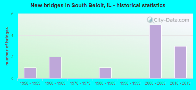
- New bridges - historical statistics
- 11950-1959
- 21960-1969
- 11980-1989
- 52000-2009
- 32010-2019


- Bridge Condition - Deck
- 50.0%Satisfactory
- 50.0%Fair

- Bridge Condition - Superstructure
- 66.7%Very good
- 16.7%Good
- 16.7%Fair

- Bridge Condition - Substructure
- 50.0%Very good
- 33.3%Good
- 16.7%Satisfactory

- Bridge Condition - Channel
- 37.5%Very good
- 12.5%Good
- 37.5%Satisfactory
- 12.5%Fair

- Bridge Condition - Culverts
- 50.0%Good
- 50.0%Satisfactory
Find on map >> Show street view
Structure Number: 1010003, Location: .05 S WISC ST LN (Lat: 42.495472, Lng: -89.036636), Route carried "on" structure: State highway 2, Year Built: 1958, Status: Open, Structure Length: 4.40m (14.44ft), Average Daily Traffic: 11,500 (year 2021), Truck Traffic: 4%, Average Future Daily Traffic: 14,200 (year 2040), Design Load: HS 20, Features Intersected: DRAINAGE DITCH
Minimum Vertical Clearance: 30+ m (98+ ft), Kilometerpoint: 114.292, Lanes on structure: 4, Base Highway Network: Yes, Owner: State Highway Agency, Approaching Roadway Width: 17.1m (56.1ft), Skew: 30 degrees, Material/Design: Steel continuous, Design/Construction: Stringer/Multi-beam, Number Of Spans In Main Unit: 2, Length of Maximum Span: 21.5m (70.5ft), Curb or Sidewalk Widths: Left: 1.5m (4.9ft), Right: 1.5m (4.9ft), Curb-To-Curb Width: 16.5m (54.1ft), Out-to-Out Width: 21.3m (69.9ft)
Condition: Deck: Satisfactory, Superstructure: Fair, Substructure: Satisfactory, Channel: Satisfactory, Operating Rating: 56.7 metric tons, Method Used To Determine Operating Rating: Load Factor (LF) rating reported by rating factor (RF) method using MS18 loading, Inventory Rating: 34.0 metric tons, Method Used To Determine Inventory Rating: Load Factor (LF) rating reported by rating factor (RF) method using MS18 loading, Structural Evaluation: Somewhat better than minimum adequacy, Deck Geometry: Meets minimum limits, Waterway Adequacy: Equal to present desirable criteria, Approach Roadway Alignment: Equal to present desirable criteria, Designated Inspection Frequency: Every 24 months, Other Special Inspection Frequency: Every 24 months, Inspection Date: August 2021, Other Special Inspection Date: August 2021, Deck Structure Type: Concrete Cast-file-Place, Wearing Surface/Protective System: Wearing Surface: Other
Find on map >> Show street view
Structure Number: 1010169, Location: 2 MI S WISCONSIN LN (Lat: 42.471419, Lng: -88.995231), Route carried "on" structure: Other road , Year Built: 2000, Status: Open, Structure Length: 6.07m (19.91ft), Average Daily Traffic: 1,950 (year 2017), Truck Traffic: 25%, Average Future Daily Traffic: 2,200 (year 2040), Design Load: HS 20, Features Intersected: I-90, Facility Carried by Structure: PRAIRIE HILL RD
Minimum Vertical Clearance: 30+ m (98+ ft), Kilometerpoint: 6.148, Lanes on structure: 2, Lanes under structure: 4, Owner: State Highway Agency, Approaching Roadway Width: 9.1m (29.9ft), Material/Design: Prestressed concrete continuous, Design/Construction: Stringer/Multi-beam, Number Of Spans In Main Unit: 2, Length of Maximum Span: 30.4m (99.7ft), Curb-To-Curb Width: 8.4m (27.6ft), Out-to-Out Width: 9.4m (30.8ft)
Condition: Deck: Satisfactory, Superstructure: Very good, Substructure: Very good, Operating Rating: 87.8 metric tons, Method Used To Determine Operating Rating: Load Factor (LF) rating reported by rating factor (RF) method using MS18 loading, Inventory Rating: 48.3 metric tons, Method Used To Determine Inventory Rating: Load Factor (LF) rating reported by rating factor (RF) method using MS18 loading, Structural Evaluation: Equal to present desirable criteria, Deck Geometry: Meets minimum limits, Underclear: Equal to present minimum criteria, Approach Roadway Alignment: Equal to present desirable criteria, Designated Inspection Frequency: Every 24 months, Inspection Date: September 2021, Deck Structure Type: Concrete Cast-file-Place, Wearing Surface/Protective System: Deck Protection: Epoxy Coated Reinforcing
Find on map >> Show street view
Structure Number: 101017, Location: E. EDGE SOUTH BELOIT (Lat: 42.491514, Lng: -88.994697), Route carried "on" structure: US 51, Year Built: 2000, Status: Open, Structure Length: 6.67m (21.88ft), Average Daily Traffic: 9,300 (year 2021), Truck Traffic: 23%, Average Future Daily Traffic: 26,200 (year 2040), Design Load: HS 20+Mod, Features Intersected: I-90
Minimum Vertical Clearance: 30+ m (98+ ft), Kilometerpoint: 658.638, Lanes on structure: 5, Lanes under structure: 4, Base Highway Network: Yes, Owner: State Highway Agency, Approaching Roadway Width: 30.2m (99.1ft), Skew: 30 degrees, Material/Design: Prestressed concrete continuous, Design/Construction: Stringer/Multi-beam, Number Of Spans In Main Unit: 2, Length of Maximum Span: 35.9m (117.8ft), Curb-To-Curb Width: 28.4m (93.2ft), Out-to-Out Width: 30.9m (101.4ft)
Condition: Deck: Fair, Superstructure: Very good, Substructure: Good, Operating Rating: 89.1 metric tons, Method Used To Determine Operating Rating: Load Factor (LF) rating reported by rating factor (RF) method using MS18 loading, Inventory Rating: 47.6 metric tons, Method Used To Determine Inventory Rating: Load Factor (LF) rating reported by rating factor (RF) method using MS18 loading, Structural Evaluation: Better than present minimum criteria, Deck Geometry: Superior to present desirable criteria, Underclear: Equal to present minimum criteria, Approach Roadway Alignment: Equal to present desirable criteria, Designated Inspection Frequency: Every 24 months, Inspection Date: April 2021, Deck Structure Type: Concrete Cast-file-Place, Wearing Surface/Protective System: Deck Protection: Epoxy Coated Reinforcing
Find on map >> Show street view
Structure Number: 1010193, Location: 1.0 MI SOUTH RT 75 (Lat: 42.474311, Lng: -88.995236), Route carried "on" structure: Interstate 39, Year Built: 2012, Status: Open, Structure Length: 4.67m (15.32ft), Average Daily Traffic: 28,150 (year 2021), Truck Traffic: 31%, Average Future Daily Traffic: 26,500 (year 2040), Design Load: HS 25 or greater, Features Intersected: DRY CREEK, Facility Carried by Structure: FAI 90 S B
Minimum Vertical Clearance: 30+ m (98+ ft), Kilometerpoint: 223.162, Lanes on structure: 2, Base Highway Network: Yes, Owner: State Highway Agency, Approaching Roadway Width: 20.3m (66.6ft), Skew: 1 degrees, Material/Design: Steel continuous, Design/Construction: Stringer/Multi-beam, Number Of Spans In Main Unit: 3, Length of Maximum Span: 21.3m (69.9ft), Curb-To-Curb Width: 20.0m (65.6ft), Out-to-Out Width: 21.4m (70.2ft)
Condition: Deck: Fair, Superstructure: Very good, Substructure: Very good, Channel: Very good, Operating Rating: 77.1 metric tons, Method Used To Determine Operating Rating: Load and Resistance Factor Rating (LRFR) rating reported by rating factor(RF) method using HL-93 loadings, Inventory Rating: 59.3 metric tons, Method Used To Determine Inventory Rating: Load and Resistance Factor Rating (LRFR) rating reported by rating factor(RF) method using HL-93 loadings, Structural Evaluation: Equal to present desirable criteria, Deck Geometry: Superior to present desirable criteria, Waterway Adequacy: Equal to present desirable criteria, Approach Roadway Alignment: Equal to present desirable criteria, Designated Inspection Frequency: Every 24 months, Inspection Date: November 2021, Deck Structure Type: Concrete Cast-file-Place, Wearing Surface/Protective System: Deck Protection: Epoxy Coated Reinforcing
Find on map >> Show street view
Structure Number: 1010194, Location: 1.0 MI SOUTH RT 75 (Lat: 42.474225, Lng: -88.995236), Route carried "on" structure: Interstate 39, Year Built: 2012, Status: Open, Structure Length: 4.67m (15.32ft), Average Daily Traffic: 28,150 (year 2021), Truck Traffic: 31%, Average Future Daily Traffic: 26,500 (year 2040), Design Load: HS 25 or greater, Features Intersected: DRY CREEK, Facility Carried by Structure: FAI 90 NB
Minimum Vertical Clearance: 30+ m (98+ ft), Kilometerpoint: 223.146, Lanes on structure: 2, Base Highway Network: Yes, Owner: State Highway Agency, Approaching Roadway Width: 18.3m (60.0ft), Skew: 1 degrees, Material/Design: Steel continuous, Design/Construction: Stringer/Multi-beam, Number Of Spans In Main Unit: 3, Length of Maximum Span: 21.3m (69.9ft), Curb-To-Curb Width: 18.1m (59.4ft), Out-to-Out Width: 19.1m (62.7ft)
Condition: Deck: Fair, Superstructure: Very good, Substructure: Very good, Channel: Very good, Operating Rating: 86.8 metric tons, Method Used To Determine Operating Rating: Load Factor (LF) rating reported by rating factor (RF) method using MS18 loading, Inventory Rating: 52.2 metric tons, Method Used To Determine Inventory Rating: Load Factor (LF) rating reported by rating factor (RF) method using MS18 loading, Structural Evaluation: Equal to present desirable criteria, Deck Geometry: Superior to present desirable criteria, Waterway Adequacy: Equal to present desirable criteria, Approach Roadway Alignment: Equal to present desirable criteria, Designated Inspection Frequency: Every 24 months, Inspection Date: November 2021, Deck Structure Type: Concrete Cast-file-Place, Wearing Surface/Protective System: Deck Protection: Epoxy Coated Reinforcing
Find on map >> Show street view
Structure Number: 1011095, Location: .13MI S PRAIRIE RD (Lat: 42.469506, Lng: -88.995225), Route carried "on" structure: Interstate 39, Year Built: 2012, Status: Open, Structure Length: 0.69m (2.26ft), Average Daily Traffic: 28,150 (year 2021), Truck Traffic: 31%, Average Future Daily Traffic: 53,000 (year 2040), Design Load: HS 20+Mod, Features Intersected: DRAINAGE, Facility Carried by Structure: I-90
Minimum Vertical Clearance: 30+ m (98+ ft), Kilometerpoint: 222.421, Lanes on structure: 4, Base Highway Network: Yes, Owner: State Highway Agency, Approaching Roadway Width: 36.3m (119.1ft), Skew: 3 degrees, Material/Design: Concrete, Design/Construction: Culvert, Number Of Spans In Main Unit: 2, Length of Maximum Span: 3.1m (10.2ft)
Condition: Channel: Very good, Culverts: Good, Operating Rating: 54.1 metric tons, Method Used To Determine Operating Rating: Assigned rating based on Load Factor Design (LFD) reported by rating factor (RF) using MS18 loading, Inventory Rating: 32.4 metric tons, Method Used To Determine Inventory Rating: Assigned rating based on Load Factor Design (LFD) reported by rating factor (RF) using MS18 loading, Structural Evaluation: Better than present minimum criteria, Waterway Adequacy: Equal to present desirable criteria, Approach Roadway Alignment: Equal to present desirable criteria, Designated Inspection Frequency: Every 24 months, Inspection Date: November 2020
Find on map >> Show street view
Structure Number: 1015047, Location: 0.7 M E MANCHESTR RD (Lat: 42.486119, Lng: -88.980461), Route carried "on" structure: County highway , Year Built: 1965, Status: Posted for load, Structure Length: 2.39m (7.84ft), Average Daily Traffic: 300 (year 2017), Truck Traffic: 2%, Average Future Daily Traffic: 550 (year 2040), Design Load: HS 15, Features Intersected: DRY RUN CREEK, Facility Carried by Structure: MIDDLE ROAD
Minimum Vertical Clearance: 30+ m (98+ ft), Kilometerpoint: 0.193, Lanes on structure: 2, Owner: Town or Township Highway Agency, Approaching Roadway Width: 9.1m (29.9ft), Skew: 4 degrees, Material/Design: Concrete, Design/Construction: Culvert, Number Of Spans In Main Unit: 4, Length of Maximum Span: 4.3m (14.1ft)
Condition: Channel: Fair, Culverts: Satisfactory, Operating Rating: 30.1 metric tons, Method Used To Determine Operating Rating: Load Factor (LF) rating reported by rating factor (RF) method using MS18 loading, Inventory Rating: 18.1 metric tons, Method Used To Determine Inventory Rating: Load Factor (LF) rating reported by rating factor (RF) method using MS18 loading, Structural Evaluation: Somewhat better than minimum adequacy, Waterway Adequacy: Better than present minimum criteria, Approach Roadway Alignment: Equal to present desirable criteria, Bridge Posting: Required (Relationship of Operating Rating to Maximum Legal Load: > 39.9% below), Designated Inspection Frequency: Every 24 months, Inspection Date: June 2020
Find on map >> Show street view
Structure Number: 1015049, Location: 1 MI E WILLOWBROOK (Lat: 42.478611, Lng: -88.986989), Route carried "on" structure: County highway , Year Built: 1960, Status: Open, Structure Length: 1.66m (5.45ft), Average Daily Traffic: 900 (year 2017), Truck Traffic: 1%, Average Future Daily Traffic: 1,400 (year 2040), Design Load: HS 15, Features Intersected: DRY RUN CREEK, Facility Carried by Structure: MANCHESTER ROAD
Minimum Vertical Clearance: 30+ m (98+ ft), Kilometerpoint: 0.306, Lanes on structure: 2, Owner: Town or Township Highway Agency, Approaching Roadway Width: 11.0m (36.1ft), Skew: 1 degrees, Material/Design: Concrete continuous, Design/Construction: Culvert, Number Of Spans In Main Unit: 4, Length of Maximum Span: 4.1m (13.5ft)
Condition: Channel: Satisfactory, Culverts: Satisfactory, Operating Rating: 32.4 metric tons, Method Used To Determine Operating Rating: Field evaluation and documented engineering judgment, Inventory Rating: 17.5 metric tons, Method Used To Determine Inventory Rating: Field evaluation and documented engineering judgment, Structural Evaluation: Meets minimum limits, Waterway Adequacy: Better than present minimum criteria, Approach Roadway Alignment: Equal to present desirable criteria, Designated Inspection Frequency: Every 24 months, Inspection Date: July 2021
Find on map >> Show street view
Structure Number: 1015155, Location: INTER WILLOWBRK & (Lat: 42.471328, Lng: -89.000625), Route carried "on" structure: Other road , Year Built: 2007, Status: Open, Structure Length: 4.15m (13.62ft), Average Daily Traffic: 3,200 (year 2017), Truck Traffic: 14%, Average Future Daily Traffic: 8,000 (year 2040), Design Load: HS 20+Mod, Features Intersected: DRY CREEK RUN, Facility Carried by Structure: PRAIRIE HIL/WILOWB
Minimum Vertical Clearance: 30+ m (98+ ft), Kilometerpoint: 5.729, Lanes on structure: 3, Base Highway Network: Yes, Owner: County Highway Agency, Approaching Roadway Width: 16.5m (54.1ft), Material/Design: Concrete, Design/Construction: Culvert, Number Of Spans In Main Unit: 7, Length of Maximum Span: 4.0m (13.1ft)
Condition: Channel: Satisfactory, Culverts: Good, Operating Rating: 77.8 metric tons, Method Used To Determine Operating Rating: Load Factor (LF) rating reported by rating factor (RF) method using MS18 loading, Inventory Rating: 46.7 metric tons, Method Used To Determine Inventory Rating: Load Factor (LF) rating reported by rating factor (RF) method using MS18 loading, Structural Evaluation: Better than present minimum criteria, Waterway Adequacy: Better than present minimum criteria, Approach Roadway Alignment: Equal to present desirable criteria, Designated Inspection Frequency: Every 48 months, Inspection Date: July 2021
Find on map >> Show street view
Structure Number: 1016302, Location: SOUTH BELOIT (Lat: 42.496072, Lng: -89.026919), Route carried "on" structure: Other road , Year Built: 1988, Status: Open, Structure Length: 4.87m (15.98ft), Average Daily Traffic: 1,600 (year 2017), Truck Traffic: 7%, Average Future Daily Traffic: 14,000 (year 2040), Design Load: HS 20, Features Intersected: TURTLE CREEK, Facility Carried by Structure: PARK AVE
Minimum Vertical Clearance: 30+ m (98+ ft), Kilometerpoint: 0.016, Lanes on structure: 2, Base Highway Network: Yes, Owner: City or Municipal Highway Agency, Approaching Roadway Width: 15.8m (51.8ft), Material/Design: Prestressed concrete, Design/Construction: Stringer/Multi-beam, Number Of Spans In Main Unit: 3, Length of Maximum Span: 16.2m (53.1ft), Curb or Sidewalk Widths: Left: 1.5m (4.9ft), Right: 1.5m (4.9ft), Curb-To-Curb Width: 15.8m (51.8ft), Out-to-Out Width: 19.5m (64.0ft)
Condition: Deck: Satisfactory, Superstructure: Good, Substructure: Good, Channel: Good, Operating Rating: 44.4 metric tons, Method Used To Determine Operating Rating: Assigned rating based on Load Factor Design (LFD) reported by rating factor (RF) using MS18 loading, Inventory Rating: 32.4 metric tons, Method Used To Determine Inventory Rating: Assigned rating based on Load Factor Design (LFD) reported by rating factor (RF) using MS18 loading, Structural Evaluation: Better than present minimum criteria, Deck Geometry: Superior to present desirable criteria, Waterway Adequacy: Superior to present desirable criteria, Approach Roadway Alignment: Better than present minimum criteria, Designated Inspection Frequency: Every 48 months, Inspection Date: May 2020, Deck Structure Type: Concrete Cast-file-Place, Wearing Surface/Protective System: Deck Protection: Epoxy Coated Reinforcing
Find on map >> Show street view
Structure Number: 1010169, Location: 2 MI S WISCONSIN LN (Lat: 42.471419, Lng: -88.995231), Route carried "under" structure: Interstate 39, Year Built: 2000, Structure Length: 0. m, Average Daily Traffic: 56,300 (year 2021), Truck Traffic: 31%, Features Intersected: I-90, Facility Carried by Structure: PRAIRIE HILL RD
Minimum Vertical Clearance: 5.11m (16.77ft), Kilometerpoint: 222.631, Lanes on structure: 2, Lanes under structure: 4, Material/Design: Prestressed concrete continuous, Design/Construction: Stringer/Multi-beam, Length of Maximum Span: 30.4m (99.7ft)
Find on map >> Show street view
Structure Number: 101017, Location: E. EDGE SOUTH BELOIT (Lat: 42.491406, Lng: -88.994411), Route carried "under" structure: Interstate 39, Year Built: 2000, Structure Length: 0. m, Average Daily Traffic: 56,300 (year 2021), Truck Traffic: 31%, Features Intersected: I-90, Facility Carried by Structure: US 51 & IL 75
Minimum Vertical Clearance: 5.28m (17.32ft), Kilometerpoint: 224.884, Lanes on structure: 5, Lanes under structure: 4, Material/Design: Prestressed concrete continuous, Design/Construction: Stringer/Multi-beam, Length of Maximum Span: 35.9m (117.8ft)