Bridge Statistics for South Greenfield, Missouri (MO)
Condition, Traffic, Stress, Structural Evaluation, Project Costs
- National Bridge Inventory (NBI) Statistics
- 17Number of bridges
- 161ft / 49.5mTotal length
- $555,000Total costs
- 7,374Total average daily traffic
- 1,039Total average daily truck traffic
- 9,857Total future (year 2039) average daily traffic
- National Bridge Inventory (NBI) Registered Bridges for South Greenfield
- No street view available for this location
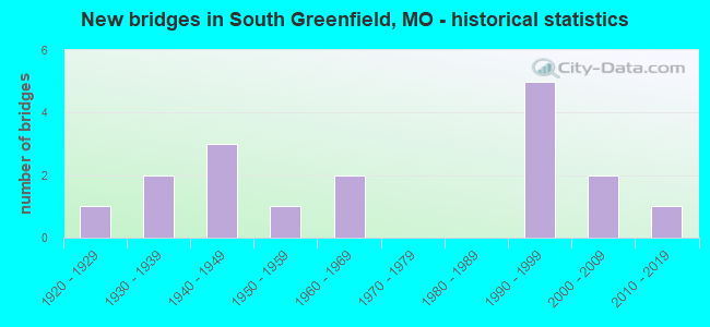
- New bridges - historical statistics
- 11920-1929
- 21930-1939
- 31940-1949
- 11950-1959
- 21960-1969
- 51990-1999
- 22000-2009
- 12010-2019

- Reconstructed bridges - Historical Statistics
- 11980-1989
- 01990-1999
- 22000-2009

- Bridge Condition - Deck
- 13.3%Very good
- 40.0%Good
- 33.3%Satisfactory
- 13.3%Fair

- Bridge Condition - Superstructure
- 20.0%Excellent
- 6.7%Very good
- 46.7%Good
- 20.0%Satisfactory
- 6.7%Fair

- Bridge Condition - Substructure
- 13.3%Excellent
- 20.0%Very good
- 13.3%Good
- 40.0%Satisfactory
- 13.3%Fair

- Bridge Condition - Channel
- 6.3%Very good
- 12.5%Good
- 50.0%Satisfactory
- 25.0%Fair
- 6.3%Poor
Find on map >> Show street view
Structure Number: 19988, Location: S 32 T 31 N R 26 W (Lat: 37.384778, Lng: -93.819544), Route carried "on" structure: County highway 243, Year Built: 1935, Status: Posted for load, Structure Length: 1.16m (3.81ft), Average Daily Traffic: 30 (year 2019), Truck Traffic: 10%, Average Future Daily Traffic: 35 (year 2039), Design Load: H 10, Features Intersected: LIMESTONE CR, Facility Carried by Structure: COUNTY RD 143
Minimum Vertical Clearance: 30+ m (98+ ft), Kilometerpoint: 0.483, Lanes on structure: 1, Owner: County Highway Agency, Approaching Roadway Width: 4.9m (16.1ft), Material/Design: Steel, Design/Construction: Stringer/Multi-beam, Number Of Spans In Main Unit: 1, Length of Maximum Span: 11.3m (37.1ft), Curb-To-Curb Width: 4.2m (13.8ft), Out-to-Out Width: 4.3m (14.1ft)
Condition: Deck: Satisfactory, Superstructure: Satisfactory, Substructure: Satisfactory, Channel: Poor, Operating Rating: 9.9 metric tons, Method Used To Determine Operating Rating: Allowable Stress (AS), Inventory Rating: 7.2 metric tons, Method Used To Determine Inventory Rating: Allowable Stress (AS), Structural Evaluation: High priority of replacement, Deck Geometry: Somewhat better than minimum adequacy, Waterway Adequacy: Somewhat better than minimum adequacy, Approach Roadway Alignment: High priority of corrective action, Bridge Posting: Required (Relationship of Operating Rating to Maximum Legal Load: > 39.9% below), Length Of Structure Improvement: 0.18m (0.59ft), Designated Inspection Frequency: Every 24 months, Inspection Date: January 2020, Bridge Improvement Cost: $131,000, Roadway Improvement Cost: $13,000, Total Project Cost: $196,000 ( Estimate for 2022), Deck Structure Type: Concrete Cast-file-Place, Wearing Surface/Protective System: Wearing Surface: Monolithic Concrete
Find on map >> Show street view
Structure Number: 22241, Location: S 31 T 31 N R 26 W (Lat: 37.377769, Lng: -93.836728), Route carried "on" structure: County highway 347, Year Built: 1991, Status: Open, Structure Length: 2.26m (7.41ft), Average Daily Traffic: 30 (year 2019), Truck Traffic: 10%, Average Future Daily Traffic: 35 (year 2039), Design Load: H 15, Features Intersected: LIMESTONE CR, Facility Carried by Structure: COUNTY RD 138
Minimum Vertical Clearance: 30+ m (98+ ft), Kilometerpoint: 0.644, Lanes on structure: 2, Owner: County Highway Agency, Approaching Roadway Width: 4.6m (15.1ft), Material/Design: Steel, Design/Construction: Stringer/Multi-beam, Number Of Spans In Main Unit: 1, Length of Maximum Span: 21.3m (69.9ft), Curb-To-Curb Width: 6.2m (20.3ft), Out-to-Out Width: 6.2m (20.3ft)
Condition: Deck: Good, Superstructure: Good, Substructure: Good, Channel: Satisfactory, Operating Rating: 50.4 metric tons, Method Used To Determine Operating Rating: Allowable Stress (AS), Inventory Rating: 24.3 metric tons, Method Used To Determine Inventory Rating: Allowable Stress (AS), Structural Evaluation: Equal to present minimum criteria, Deck Geometry: Somewhat better than minimum adequacy, Waterway Adequacy: Somewhat better than minimum adequacy, Approach Roadway Alignment: Equal to present minimum criteria, Designated Inspection Frequency: Every 24 months, Inspection Date: January 2020, Deck Structure Type: Concrete Cast-file-Place, Wearing Surface/Protective System: Wearing Surface: Monolithic Concrete
Find on map >> Show street view
Structure Number: 23315, Location: S 11 T 30 N R 27 W (Lat: 37.353814, Lng: -93.871236), Route carried "on" structure: County highway 403, Year Built: 1948, Status: Posted for load, Structure Length: 0.94m (3.08ft), Average Daily Traffic: 25 (year 2019), Truck Traffic: 10%, Average Future Daily Traffic: 29 (year 2039), Design Load: H 10, Features Intersected: W LIMESTONE CR, Facility Carried by Structure: COUNTY RD 115
Minimum Vertical Clearance: 30+ m (98+ ft), Kilometerpoint: 0.644, Lanes on structure: 1, Owner: County Highway Agency, Approaching Roadway Width: 4.9m (16.1ft), Material/Design: Steel, Design/Construction: Stringer/Multi-beam, Number Of Spans In Main Unit: 1, Length of Maximum Span: 8.5m (27.9ft), Curb-To-Curb Width: 4.5m (14.8ft), Out-to-Out Width: 4.8m (15.7ft)
Condition: Deck: Satisfactory, Superstructure: Good, Substructure: Satisfactory, Channel: Satisfactory, Operating Rating: 14.4 metric tons, Method Used To Determine Operating Rating: Allowable Stress (AS), Inventory Rating: 9.0 metric tons, Method Used To Determine Inventory Rating: Allowable Stress (AS), Structural Evaluation: High priority of replacement, Deck Geometry: Equal to present minimum criteria, Waterway Adequacy: Equal to present minimum criteria, Approach Roadway Alignment: Equal to present minimum criteria, Bridge Posting: Required (Relationship of Operating Rating to Maximum Legal Load: > 39.9% below), Length Of Structure Improvement: 0.16m (0.52ft), Designated Inspection Frequency: Every 24 months, Inspection Date: January 2020, Bridge Improvement Cost: $115,000, Roadway Improvement Cost: $12,000, Total Project Cost: $173,000 ( Estimate for 2022), Deck Structure Type: Concrete Cast-file-Place, Wearing Surface/Protective System: Wearing Surface: Monolithic Concrete
Find on map >> Show street view
Structure Number: 2332, Location: S 11 T 30 N R 27 W (Lat: 37.348378, Lng: -93.871992), Route carried "on" structure: County highway 403, Year Built: 1948, Status: Posted for load, Structure Length: 1.07m (3.51ft), Average Daily Traffic: 25 (year 2019), Truck Traffic: 10%, Average Future Daily Traffic: 29 (year 2039), Design Load: H 10, Features Intersected: W LIMESTONE CR, Facility Carried by Structure: COUNTY RD 115
Minimum Vertical Clearance: 30+ m (98+ ft), Kilometerpoint: 1.287, Lanes on structure: 1, Owner: County Highway Agency, Approaching Roadway Width: 4.9m (16.1ft), Material/Design: Steel, Design/Construction: Stringer/Multi-beam, Number Of Spans In Main Unit: 1, Length of Maximum Span: 10.4m (34.1ft), Curb-To-Curb Width: 4.4m (14.4ft), Out-to-Out Width: 4.9m (16.1ft)
Condition: Deck: Fair, Superstructure: Good, Substructure: Satisfactory, Channel: Fair, Operating Rating: 9.0 metric tons, Method Used To Determine Operating Rating: Allowable Stress (AS), Inventory Rating: 5.4 metric tons, Method Used To Determine Inventory Rating: Allowable Stress (AS), Structural Evaluation: High priority of replacement, Deck Geometry: Equal to present minimum criteria, Waterway Adequacy: Equal to present minimum criteria, Approach Roadway Alignment: Equal to present minimum criteria, Bridge Posting: Required (Relationship of Operating Rating to Maximum Legal Load: > 39.9% below), Length Of Structure Improvement: 0.17m (0.56ft), Designated Inspection Frequency: Every 24 months, Inspection Date: January 2020, Bridge Improvement Cost: $124,000, Roadway Improvement Cost: $12,000, Total Project Cost: $186,000 ( Estimate for 2022), Deck Structure Type: Concrete Cast-file-Place, Wearing Surface/Protective System: Wearing Surface: Monolithic Concrete
Find on map >> Show street view
Structure Number: 23375, Location: S 12 T 30 N R 27 W (Lat: 37.352006, Lng: -93.855289), Route carried "on" structure: County highway 406, Year Built: 1945, Status: Open, Structure Length: 1.49m (4.89ft), Average Daily Traffic: 25 (year 2019), Truck Traffic: 10%, Average Future Daily Traffic: 29 (year 2039), Design Load: H 10, Features Intersected: W LIMESTONE CR, Facility Carried by Structure: COUNTY RD 125
Minimum Vertical Clearance: 30+ m (98+ ft), Kilometerpoint: 3.058, Lanes on structure: 1, Owner: County Highway Agency, Approaching Roadway Width: 4.9m (16.1ft), Material/Design: Concrete, Design/Construction: Tee Beam, Number Of Spans In Main Unit: 1, Length of Maximum Span: 14.3m (46.9ft), Curb-To-Curb Width: 3.9m (12.8ft), Out-to-Out Width: 4.3m (14.1ft)
Condition: Deck: Satisfactory, Superstructure: Satisfactory, Substructure: Fair, Channel: Fair, Operating Rating: 49.5 metric tons, Method Used To Determine Operating Rating: Allowable Stress (AS), Inventory Rating: 22.5 metric tons, Method Used To Determine Inventory Rating: Allowable Stress (AS), Structural Evaluation: Somewhat better than minimum adequacy, Deck Geometry: Meets minimum limits, Waterway Adequacy: Somewhat better than minimum adequacy, Approach Roadway Alignment: Equal to present minimum criteria, Designated Inspection Frequency: Every 24 months, Inspection Date: January 2020, Deck Structure Type: Concrete Cast-file-Place, Wearing Surface/Protective System: Wearing Surface: Monolithic Concrete
Find on map >> Show street view
Structure Number: 23467, Location: S 7 T 30 N R 26 W (Lat: 37.354114, Lng: -93.829808), Route carried "on" structure: County highway 408, Year Built: 1934, Year Reconstructed: 1992, Status: Open, Structure Length: 0.85m (2.79ft), Average Daily Traffic: 15 (year 2019), Truck Traffic: 10%, Average Future Daily Traffic: 17 (year 2039), Design Load: H 15, Features Intersected: LIMESTONE CR BR, Facility Carried by Structure: COUNTY RD 135
Minimum Vertical Clearance: 30+ m (98+ ft), Kilometerpoint: 2.575, Lanes on structure: 2, Owner: County Highway Agency, Approaching Roadway Width: 5.5m (18.0ft), Material/Design: Steel, Design/Construction: Stringer/Multi-beam, Number Of Spans In Main Unit: 1, Length of Maximum Span: 8.2m (26.9ft), Curb-To-Curb Width: 6.2m (20.3ft), Out-to-Out Width: 6.2m (20.3ft)
Condition: Deck: Satisfactory, Superstructure: Good, Substructure: Satisfactory, Channel: Fair, Operating Rating: 45.0 metric tons, Method Used To Determine Operating Rating: Field evaluation and documented engineering judgment, Inventory Rating: 30.6 metric tons, Method Used To Determine Inventory Rating: Field evaluation and documented engineering judgment, Structural Evaluation: Equal to present minimum criteria, Deck Geometry: Somewhat better than minimum adequacy, Waterway Adequacy: Equal to present minimum criteria, Approach Roadway Alignment: Equal to present minimum criteria, Designated Inspection Frequency: Every 24 months, Inspection Date: January 2020, Deck Structure Type: Concrete Cast-file-Place, Wearing Surface/Protective System: Wearing Surface: Monolithic Concrete
Find on map >> Show street view
Structure Number: 23519, Location: S 17 T 30 N R 26 W (Lat: 37.337267, Lng: -93.825778), Route carried "on" structure: County highway 412, Year Built: 2000, Status: Open, Structure Length: 1.01m (3.31ft), Average Daily Traffic: 30 (year 2019), Truck Traffic: 10%, Average Future Daily Traffic: 35 (year 2039), Features Intersected: LIMESTONE CR BR, Facility Carried by Structure: COUNTY RD 141
Minimum Vertical Clearance: 30+ m (98+ ft), Kilometerpoint: 0.805, Lanes on structure: 2, Owner: County Highway Agency, Approaching Roadway Width: 4.6m (15.1ft), Skew: 3 degrees, Material/Design: Concrete, Design/Construction: Slab, Number Of Spans In Main Unit: 1, Length of Maximum Span: 9.1m (29.9ft), Curb-To-Curb Width: 6.9m (22.6ft), Out-to-Out Width: 7.3m (24.0ft)
Condition: Deck: Good, Superstructure: Good, Substructure: Very good, Channel: Good, Operating Rating: 40.5 metric tons, Method Used To Determine Operating Rating: Load Factor (LF), Inventory Rating: 24.3 metric tons, Method Used To Determine Inventory Rating: Load Factor (LF), Structural Evaluation: Equal to present minimum criteria, Deck Geometry: Somewhat better than minimum adequacy, Waterway Adequacy: Better than present minimum criteria, Approach Roadway Alignment: Equal to present desirable criteria, Designated Inspection Frequency: Every 24 months, Inspection Date: January 2020, Deck Structure Type: Concrete Cast-file-Place, Wearing Surface/Protective System: Wearing Surface: Monolithic Concrete
Find on map >> Show street view
Structure Number: 24655, Location: S 6 T 30 N R 26 W (Lat: 37.368906, Lng: -93.841992), Route carried "on" structure: County highway 39, Year Built: 1924, Status: Open, Structure Length: 1.98m (6.50ft), Average Daily Traffic: 50 (year 2019), Truck Traffic: 10%, Average Future Daily Traffic: 58 (year 2039), Design Load: H 15, Features Intersected: BUFFALO CR, Facility Carried by Structure: S. DADE 144
Minimum Vertical Clearance: 30+ m (98+ ft), Kilometerpoint: 21.517, Lanes on structure: 2, Owner: County Highway Agency, Approaching Roadway Width: 6.4m (21.0ft), Material/Design: Concrete, Design/Construction: Tee Beam, Number Of Spans In Main Unit: 2, Length of Maximum Span: 9.1m (29.9ft), Curb-To-Curb Width: 6.1m (20.0ft), Out-to-Out Width: 7.1m (23.3ft)
Condition: Deck: Fair, Superstructure: Fair, Substructure: Fair, Channel: Satisfactory, Operating Rating: 42.3 metric tons, Method Used To Determine Operating Rating: Allowable Stress (AS), Inventory Rating: 18.0 metric tons, Method Used To Determine Inventory Rating: Allowable Stress (AS), Structural Evaluation: Somewhat better than minimum adequacy, Deck Geometry: Somewhat better than minimum adequacy, Waterway Adequacy: Better than present minimum criteria, Approach Roadway Alignment: Equal to present desirable criteria, Designated Inspection Frequency: Every 24 months, Inspection Date: January 2020, Deck Structure Type: Concrete Cast-file-Place, Wearing Surface/Protective System: Wearing Surface: Bituminous, Membrane: Built-up
Find on map >> Show street view
Structure Number: 31446, Location: S 6 T 30 N R 26 W (Lat: 37.371200, Lng: -93.838325), Route carried "on" structure: County highway 408, Year Built: 2004, Status: Open, Structure Length: 3.40m (11.15ft), Average Daily Traffic: 30 (year 2019), Truck Traffic: 5%, Average Future Daily Traffic: 35 (year 2039), Design Load: HS 20, Features Intersected: LIMESTONE CR, Facility Carried by Structure: COUNTY RD 135
Minimum Vertical Clearance: 30+ m (98+ ft), Kilometerpoint: 0.322, Lanes on structure: 2, Owner: County Highway Agency, Approaching Roadway Width: 5.5m (18.0ft), Skew: 2 degrees, Material/Design: Steel, Design/Construction: Stringer/Multi-beam, Number Of Spans In Main Unit: 1, Number Of Approach Spans: 1, Length of Maximum Span: 21.3m (69.9ft), Curb-To-Curb Width: 7.3m (24.0ft), Out-to-Out Width: 7.5m (24.6ft)
Condition: Deck: Very good, Superstructure: Very good, Substructure: Good, Channel: Satisfactory, Operating Rating: 49.5 metric tons, Method Used To Determine Operating Rating: Load Factor (LF), Inventory Rating: 29.7 metric tons, Method Used To Determine Inventory Rating: Load Factor (LF), Structural Evaluation: Better than present minimum criteria, Deck Geometry: Equal to present minimum criteria, Waterway Adequacy: Equal to present minimum criteria, Approach Roadway Alignment: Equal to present minimum criteria, Designated Inspection Frequency: Every 24 months, Inspection Date: January 2020, Deck Structure Type: Concrete Cast-file-Place, Wearing Surface/Protective System: Wearing Surface: Monolithic Concrete
Find on map >> Show street view
Structure Number: 35087, Location: S 33 T 31 N R 26 W (Lat: 37.383889, Lng: -93.798861), Route carried "on" structure: County highway 348, Year Built: 2015, Status: Open, Structure Length: 5.33m (17.49ft), Average Daily Traffic: 30 (year 2019), Truck Traffic: 10%, Average Future Daily Traffic: 35 (year 2039), Design Load: HS 20, Features Intersected: TURNBACK CR, Facility Carried by Structure: COUNTY RD 138
Minimum Vertical Clearance: 30+ m (98+ ft), Kilometerpoint: 0.483, Lanes on structure: 2, Owner: County Highway Agency, Approaching Roadway Width: 6.1m (20.0ft), Skew: 1 degrees, Material/Design: Prestressed concrete, Design/Construction: Box Beam or Girders - Multiple, Number Of Spans In Main Unit: 3, Length of Maximum Span: 21.3m (69.9ft), Curb-To-Curb Width: 6.1m (20.0ft), Out-to-Out Width: 6.2m (20.3ft)
Condition: Deck: Very good, Superstructure: Excellent, Substructure: Very good, Channel: Very good, Operating Rating: 64.8 metric tons, Method Used To Determine Operating Rating: Load and Resistance Factor (LRFR), Inventory Rating: 38.7 metric tons, Method Used To Determine Inventory Rating: Load and Resistance Factor (LRFR), Structural Evaluation: Equal to present desirable criteria, Deck Geometry: Somewhat better than minimum adequacy, Waterway Adequacy: Somewhat better than minimum adequacy, Approach Roadway Alignment: Equal to present minimum criteria, Designated Inspection Frequency: Every 24 months, Inspection Date: January 2020, Deck Structure Type: Concrete Cast-file-Place, Wearing Surface/Protective System: Wearing Surface: Monolithic Concrete
Find on map >> Show street view
Structure Number: 4018, Location: S 19 T 30 N R 36 W (Lat: 37.321081, Lng: -93.835378), Route carried "on" structure: State highway 39, Year Built: 1990, Status: Open, Structure Length: 1.05m (3.44ft), Average Daily Traffic: 1,475 (year 2021), Truck Traffic: 16%, Average Future Daily Traffic: 1,991 (year 2041), Design Load: HS 20, Features Intersected: HONEY CR
Minimum Vertical Clearance: 30+ m (98+ ft), Kilometerpoint: 71.434, Lanes on structure: 2, Base Highway Network: Yes, Owner: State Highway Agency, Approaching Roadway Width: 11.0m (36.1ft), Material/Design: Concrete continuous, Design/Construction: Culvert, Number Of Spans In Main Unit: 3, Length of Maximum Span: 3.4m (11.2ft)
Condition: Channel: Satisfactory, Culverts: Satisfactory, Operating Rating: 98.1 metric tons, Method Used To Determine Operating Rating: Load Factor (LF), Inventory Rating: 58.5 metric tons, Method Used To Determine Inventory Rating: Load Factor (LF), Structural Evaluation: Equal to present minimum criteria, Waterway Adequacy: Equal to present desirable criteria, Approach Roadway Alignment: Equal to present desirable criteria, Designated Inspection Frequency: Every 24 months, Inspection Date: November 2020
Find on map >> Show street view
Structure Number: 4157, Location: S 1 T 30 N R 27 W (Lat: 37.372000, Lng: -93.847028), Route carried "on" structure: State highway 39, Year Built: 1995, Status: Open, Structure Length: 4.33m (14.21ft), Average Daily Traffic: 1,583 (year 2021), Truck Traffic: 14%, Average Future Daily Traffic: 2,137 (year 2041), Design Load: HS 20, Features Intersected: BNSF RR
Minimum Vertical Clearance: 4.65m (15.26ft), Kilometerpoint: 65.185, Lanes on structure: 2, Base Highway Network: Yes, Owner: State Highway Agency, Approaching Roadway Width: 12.2m (40.0ft), Skew: 1 degrees, Material/Design: Prestressed concrete continuous, Design/Construction: Stringer/Multi-beam, Number Of Spans In Main Unit: 3, Length of Maximum Span: 17.4m (57.1ft), Curb or Sidewalk Widths: Left: 0.2m (0.7ft), Right: 0.2m (0.7ft), Curb-To-Curb Width: 11.8m (38.7ft), Out-to-Out Width: 12.6m (41.3ft)
Condition: Deck: Good, Superstructure: Excellent, Substructure: Excellent, Operating Rating: 67.5 metric tons, Method Used To Determine Operating Rating: Load Factor (LF), Inventory Rating: 32.4 metric tons, Method Used To Determine Inventory Rating: Load Factor (LF), Structural Evaluation: Equal to present desirable criteria, Deck Geometry: Equal to present minimum criteria, Underclear: Equal to present minimum criteria, Approach Roadway Alignment: Equal to present desirable criteria, Designated Inspection Frequency: Every 24 months, Inspection Date: November 2020, Deck Structure Type: Concrete Cast-file-Place, Wearing Surface/Protective System: Wearing Surface: Monolithic Concrete, Deck Protection: Epoxy Coated Reinforcing
Find on map >> Show street view
Structure Number: 4158, Location: S 1 T 30 N R 27 W (Lat: 37.370722, Lng: -93.846875), Route carried "on" structure: State highway 39, Year Built: 1995, Status: Open, Structure Length: 7.96m (26.12ft), Average Daily Traffic: 1,583 (year 2021), Truck Traffic: 14%, Average Future Daily Traffic: 2,137 (year 2041), Design Load: HS 20, Features Intersected: BUFFALO CR
Minimum Vertical Clearance: 30+ m (98+ ft), Kilometerpoint: 65.311, Lanes on structure: 2, Base Highway Network: Yes, Owner: State Highway Agency, Approaching Roadway Width: 12.2m (40.0ft), Skew: 1 degrees, Material/Design: Prestressed concrete continuous, Design/Construction: Stringer/Multi-beam, Number Of Spans In Main Unit: 3, Length of Maximum Span: 26.6m (87.3ft), Curb or Sidewalk Widths: Left: 0.2m (0.7ft), Right: 0.2m (0.7ft), Curb-To-Curb Width: 11.8m (38.7ft), Out-to-Out Width: 12.6m (41.3ft)
Condition: Deck: Good, Superstructure: Excellent, Substructure: Very good, Channel: Good, Operating Rating: 82.8 metric tons, Method Used To Determine Operating Rating: Load Factor (LF), Inventory Rating: 40.5 metric tons, Method Used To Determine Inventory Rating: Load Factor (LF), Structural Evaluation: Equal to present desirable criteria, Deck Geometry: Equal to present minimum criteria, Waterway Adequacy: Equal to present desirable criteria, Approach Roadway Alignment: Equal to present desirable criteria, Designated Inspection Frequency: Every 24 months, Inspection Date: November 2020, Deck Structure Type: Concrete Cast-file-Place, Wearing Surface/Protective System: Wearing Surface: Monolithic Concrete, Deck Protection: Epoxy Coated Reinforcing
Find on map >> Show street view
Structure Number: 4159, Location: S 6 T 30 N R 26 W (Lat: 37.366186, Lng: -93.841775), Route carried "on" structure: State highway 39, Year Built: 1995, Status: Open, Structure Length: 8.81m (28.90ft), Average Daily Traffic: 1,583 (year 2021), Truck Traffic: 14%, Average Future Daily Traffic: 2,137 (year 2041), Design Load: HS 20, Features Intersected: LIMESTONE CR
Minimum Vertical Clearance: 30+ m (98+ ft), Kilometerpoint: 65.998, Lanes on structure: 2, Base Highway Network: Yes, Owner: State Highway Agency, Approaching Roadway Width: 12.2m (40.0ft), Skew: 1 degrees, Material/Design: Prestressed concrete, Design/Construction: Stringer/Multi-beam, Number Of Spans In Main Unit: 5, Length of Maximum Span: 18.9m (62.0ft), Curb or Sidewalk Widths: Left: 0.2m (0.7ft), Right: 0.2m (0.7ft), Curb-To-Curb Width: 11.8m (38.7ft), Out-to-Out Width: 12.6m (41.3ft)
Condition: Deck: Good, Superstructure: Good, Substructure: Excellent, Channel: Satisfactory, Operating Rating: 70.2 metric tons, Method Used To Determine Operating Rating: Load Factor (LF), Inventory Rating: 40.5 metric tons, Method Used To Determine Inventory Rating: Load Factor (LF), Structural Evaluation: Better than present minimum criteria, Deck Geometry: Equal to present minimum criteria, Waterway Adequacy: Equal to present desirable criteria, Approach Roadway Alignment: Equal to present desirable criteria, Designated Inspection Frequency: Every 24 months, Inspection Date: November 2020, Deck Structure Type: Concrete Cast-file-Place, Wearing Surface/Protective System: Wearing Surface: Monolithic Concrete, Deck Protection: Epoxy Coated Reinforcing
Find on map >> Show street view
Structure Number: 6946, Location: S 17 T 30 N R 26 W (Lat: 37.329875, Lng: -93.825103), Route carried "on" structure: State highway K, Year Built: 1957, Status: Open, Structure Length: 1.05m (3.44ft), Average Daily Traffic: 368 (year 2021), Truck Traffic: 13%, Average Future Daily Traffic: 478 (year 2041), Design Load: H 10, Features Intersected: HONEY CR
Minimum Vertical Clearance: 30+ m (98+ ft), Kilometerpoint: 0.731, Lanes on structure: 2, Owner: State Highway Agency, Approaching Roadway Width: 7.3m (24.0ft), Material/Design: Concrete continuous, Design/Construction: Culvert, Number Of Spans In Main Unit: 3, Length of Maximum Span: 3.4m (11.2ft), Curb-To-Curb Width: 7.6m (24.9ft), Out-to-Out Width: 8.2m (26.9ft)
Condition: Channel: Fair, Culverts: Satisfactory, Operating Rating: 47.7 metric tons, Method Used To Determine Operating Rating: Load Factor (LF), Inventory Rating: 28.8 metric tons, Method Used To Determine Inventory Rating: Load Factor (LF), Structural Evaluation: Equal to present minimum criteria, Deck Geometry: Somewhat better than minimum adequacy, Waterway Adequacy: Equal to present desirable criteria, Approach Roadway Alignment: Equal to present desirable criteria, Designated Inspection Frequency: Every 24 months, Inspection Date: November 2020
Find on map >> Show street view
Structure Number: 8244, Location: S 22 T 30 N R 27 W (Lat: 37.329047, Lng: -93.881500), Route carried "on" structure: State highway Z, Year Built: 1962, Year Reconstructed: 2009, Status: Open, Structure Length: 3.57m (11.71ft), Average Daily Traffic: 246 (year 2021), Truck Traffic: 14%, Average Future Daily Traffic: 320 (year 2041), Design Load: H 15, Features Intersected: GLASS HOLLOW BR
Minimum Vertical Clearance: 30+ m (98+ ft), Kilometerpoint: 7.327, Lanes on structure: 2, Owner: State Highway Agency, Approaching Roadway Width: 7.3m (24.0ft), Skew: 2 degrees, Material/Design: Prestressed concrete, Design/Construction: Box Beam or Girders - Multiple, Number Of Spans In Main Unit: 3, Length of Maximum Span: 14.2m (46.6ft), Curb-To-Curb Width: 7.3m (24.0ft), Out-to-Out Width: 7.4m (24.3ft)
Condition: Deck: Good, Superstructure: Good, Substructure: Satisfactory, Channel: Satisfactory, Operating Rating: 61.2 metric tons, Method Used To Determine Operating Rating: Load Factor (LF), Inventory Rating: 36.9 metric tons, Method Used To Determine Inventory Rating: Load Factor (LF), Structural Evaluation: Equal to present minimum criteria, Deck Geometry: Somewhat better than minimum adequacy, Waterway Adequacy: Equal to present desirable criteria, Approach Roadway Alignment: Equal to present minimum criteria, Designated Inspection Frequency: Every 24 months, Inspection Date: November 2020, Deck Structure Type: Concrete Precast Panels, Wearing Surface/Protective System: Wearing Surface: Bituminous, Membrane: Preformed Fabric
Find on map >> Show street view
Structure Number: 8245, Location: S 24 T 30 N R 27 W (Lat: 37.326892, Lng: -93.859956), Route carried "on" structure: State highway Z, Year Built: 1962, Year Reconstructed: 2009, Status: Open, Structure Length: 3.20m (10.50ft), Average Daily Traffic: 246 (year 2021), Truck Traffic: 14%, Average Future Daily Traffic: 320 (year 2041), Design Load: H 15, Features Intersected: LIMESTONE CR
Minimum Vertical Clearance: 30+ m (98+ ft), Kilometerpoint: 9.498, Lanes on structure: 2, Owner: State Highway Agency, Approaching Roadway Width: 7.3m (24.0ft), Skew: 2 degrees, Material/Design: Prestressed concrete, Design/Construction: Box Beam or Girders - Multiple, Number Of Spans In Main Unit: 3, Length of Maximum Span: 10.8m (35.4ft), Curb-To-Curb Width: 7.3m (24.0ft), Out-to-Out Width: 7.3m (24.0ft)
Condition: Deck: Satisfactory, Superstructure: Satisfactory, Substructure: Satisfactory, Channel: Satisfactory, Operating Rating: 64.8 metric tons, Method Used To Determine Operating Rating: Load Factor (LF), Inventory Rating: 38.7 metric tons, Method Used To Determine Inventory Rating: Load Factor (LF), Structural Evaluation: Equal to present minimum criteria, Deck Geometry: Somewhat better than minimum adequacy, Waterway Adequacy: Equal to present minimum criteria, Approach Roadway Alignment: Equal to present desirable criteria, Designated Inspection Frequency: Every 24 months, Inspection Date: November 2020, Deck Structure Type: Concrete Precast Panels, Wearing Surface/Protective System: Wearing Surface: Bituminous, Membrane: Preformed Fabric, Deck Protection: Epoxy Coated Reinforcing